
-
 5649 Hits
-
 0% Score
-
 0 Votes
|
|
Route |
|---|---|
|
|
38.50230°N / 109.2061°W |
|
|
Hike ~ Little scramble |
|
|
Half a day |
|
|
Walk-up |
|
|
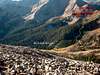
Approach
See getting there - Beaver Basin
Route Description
Beaver Basin – Via Jackass Pass
3.0 miles one way
2,350’ of elevation gain
Start at Beaver Basin and follow the jeep trail up through a few switchbacks. Long wheel base vehicles will have trouble negotiating these turns so the hiking will start here. Follow the road and slight trail heading southwest. Gain the ridgeline to you left or southeast, after gaining the ridgeline it is a short distance to Jackass Pass (0.8 miles). From here start contouring southeast around the southwest side of Dry Peak to the saddle between Dry Peak and Manns. Continue up to Manns and descend the other side, contour around the southwest side of another small peak along the ridgeline. This should drop you to the saddle at the base of Tomasaki (2.4 miles). From here is only another 0.6 miles and 600 feet of elevation to the peak. It becomes steeper than most of the route to this point, but a good use trail will help you to reach the peak.
If wanting a little change for the return, stay right before reaching Manns and cross (sidehill) to the small saddle located northeast of Manns. See map for approximate routing.
 |  |  |
Essential Gear
Snow - Crampons
Miscellaneous Info
If you have information about this route that doesn't pertain to any of the other sections, please add it here.