
|
|
Route |
|---|---|
|
|
38.73370°N / 106.4161°W |
|
|
Loop Hike with some Scrambling |
|
|
Most of a day |
|
|
Class 3 |
|
|
Approach
Please refer to the "Getting There" section of the main page for directions to the junction of Forest Service Roads 344 and 344A.Route Description
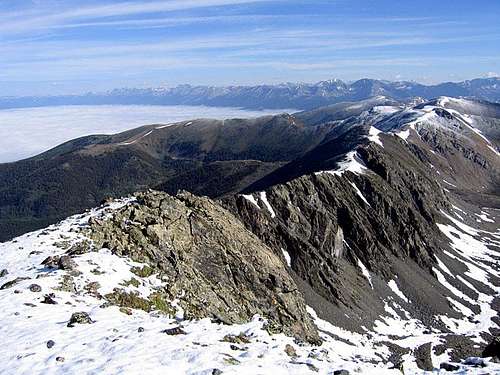 Emma Burr Mountain's north ridge
RT Distance: 11 miles
Elevation Gain: 4170'
The Emma Burr Grand Slam gives you a lot of bang for your buck. Four ranked thirteeners – Emma Burr Mountain, Mount Kreutzer, Chalk Rock Mountain, and Jones Mountain – are the reward for a beautiful day spent deep in the Sawatch Range. Considering that many Sawatch peaks require over 4000' of elevation gain to gain just one summit, this route is a real treat. Plus, the only time you'll retrace a step is while going up and down Jones Mountain. This route can be run in either direction, or it can be broken up into segments.
From the junction of Forest Service Roads 344 and 344A, hike west on FS-344, which soon leaves South Cottonwood Creek for Mineral Creek. Follow this road to its end below Emma Burr's east ridge. The road actually goes further than the Cumberland Pass quadrangle indicates. The quad says the road ends at a mine, but it continues almost all the way to the east ridge. Hike up a short, easy class 2 gully to reach the saddle between Emma Burr and UN 12,900 (for those who want a longer day, UN 12,900 is a straightforward 2-mile round-trip ridge walk from this saddle, requiring about 330' of additional elevation gain). Hike up Emma Burr's east ridge to the summit. With some minimal routefinding, you can keep the difficulty at class 2, but there is some light scrambling available as well.
Now it's time to hike 3.5 miles on the Continental Divide! Leave the summit and descend Emma Burr's north ridge. Take the time to enjoy some special views looking down this ridge's east face, however, you may not want to stay on the ridge crest the entire way because it goes slower than staying more on the west side of the ridge. Despite this ridge's rugged looks, the crest offers only a paltry bit of scrambling from time to time. After descending from Point 13,055, you'll finally be at the saddle between Emma Burr and Mount Kreutzer. Kreutzer is an easy quarter-mile and 350' talus climb from here.
The segment from Kreutzer to Chalk Rock Mountain is gentler than the section you've just completed. A rolling grassy ridge is all that separates you from your next goal, and you'll move a lot more quickly than you have been. The easy climb to the summit of Chalk Rock brings you to the crux of the day, the descent of Chalk Rock's east ridge.
Chalk Rock's east ridge begins innocuously enough, but as you climb lower, the difficulty increases to third-class scrambling. Keep your eyes open for the ramp on the ridge's south side that lets you bypass the toughest section. Near the end of the ramp, you can either regain the crest for some more scrambling, or you can continue to the Chalk Rock/Jones Mountain saddle directly.
From the Chalk Rock/Jones saddle, hike southeast for about a half-mile and 600 vertical feet to the summit of Jones Mountain. Follow your ascent route back to the saddle. From the saddle, there's a loose, rubble-filled gully that runs south toward the unnamed lake in Mineral Basin. Hike down this gully (class 2), and look for a game trail that will help you stay on stabler terrain. From the lake, hike southeast until you find FS-344A, which will take you all the way back to your vehicle.
Essential Gear
I only recommend this route for summer and early autumn. It's just too long of a day for any other time because of the lengthy approach from Cottonwood Lake. In dry conditions, all you'll need is a sturdy pair of boots.One important point to note is that there isn't a great escape route while you're in between Emma Burr Mountain and Mount Kreutzer. Frankly the east face of Emma Burr's north ridge is for the most part impassable. A descent down the west side of the ridge is doable, but you'd be on the wrong side of the Continental Divide from your vehicle. So let me be clear, make sure the weather is on your side before you start a traverse from Emma Burr to Kreutzer!