

-
 8597 Hits
-
 72.23% Score
-
 3 Votes
|
|
Route |
|---|---|
|
|
40.60000°N / 111.5577°W |
|
|
Mountaineering, Scrambling |
|
|
Most of a day |
|
|
Class 3+ |
|
|
Approach
Mill B THTake the 6200 S exit off Interstate 215 and follow the signs east for the Brighton/Solitude ski resorts up Big Cottonwood Canyon. The trailhead is located 4.5 miles up Big Cottonwood Canyon from the intersection of Wasatch Blvd at the mouth of the canyon. There is a parking lot on the righthand side of the road for the trailhead, as well as the trailhead for the Broad's Fork approach to Twin Peaks, Sunrise, & Dromedary peaks. The trail is located just past the restrooms on the east side of the lot and follows a paved trail for 1/4 of a mile.
Broads Fork TH
This trailhead is located at the same parking lot as the Mill B Trailhead, but it begins on the west side of the parking lot.
Stats
via Lake BlancheDistance: 4.45 mi (1-way)
Elevation Gain: 5,072'
Slope: 1,140 ft/mi
via Broads Fork
Distance: 4.5 mi (1-way)
Elevation Gain: 5,130'
Slope: 1,140 ft/mi
TH Elevation: 6,200 ft
via Lake Blanche
While on the paved portion a tributary comes in from the south and a trail breaks off from the pavement here. Follow the trail through nice meadows and beautiful views of Mill B Canyon.(Note: At one point one will see an enomrous smooth slab that is extruded up above the trees on the west side of the canyon. This slab provides many variations of some low 5th class climbing. Be sure to bring your microstoppers!
Eventually Lake Blanche is reached. Follow the trail along the north side of the lake. The trail becomes more faint, but be sure to continue following along the north side of Lake Florence and Lake Lillian. Cross the dam at Lake Lillian, cross the gulley, and head up the subtle ridge. From here just follow the series of rock slabs, initially heading south but gradually turning farther west. If one is careful with routefinding, the bushwacking is almost non-existent. For those who aren't, better bring long pants!
At ca. 9,300 ft, drop to the north of the ridge and head up a large bowl. The ridge can be reached by scrambling along an angled wall of rock along the right-most side of the bowl (cl. 2-3) . Follow the ridge to the base of Dromedary Pk. From here one can take either the Northeast Face or the North Ridge.
via Broads Fork
Follow the maintained trail as it cuts west and then winds its way into the Broads Fork drainage, making one switchback along the way. After hiking about a mile through spruce and fir forests, the trail crosses the stream on a sturdy bridge and continues its steep climb up the canyon, passing through stands of shady trees and sunny meadows. There are several times when the steepness eases up, but only temporarily.Finally the lower meadow is reached at 8,240 feet (good campsite, but somewhat popular). From here the trail fades away, but keep to the use-trails that fork left to a stream crossing on improvised bridges. Follow the path as it climbs more rugged terrain (cl. 2) to the upper meadow, where one is surrounded by the towering masses of Mt Dromedary, Sunrise Pk, and the Broads Fork Twin Peaks. Head toward the notch between Sunrise Pk and Mt Dromedary as if you're climbing them this way. Then cut east across the bowl below the north face of Dromedary peak and scramble up a talus slope (cl. 2, loose rock) to reach the base of the North Ridge.
Route Description
Northeast FaceCircle around the eastern flanks of the peak until one comes across the faint hikers trail leading to the top. Follow this trail as it winds its way through the series of cliffs on the eastern slope to the summit (cl. 2-3).
Once above the saddle north of the peak, take care not to stray too far climber's left as there are some dangerous slabs further out on the face. I haven't done the route in a long while, but runbyu1's trip report below reminds me of my experiences on where to go and not to go on this face!
 Route Up Dromedary From Lake Blanche (in red) Route Up Dromedary From Lake Blanche (in red) |
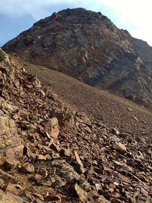 Click and zoom to view the red line at runbyu1's attempt at representing the easier route Click and zoom to view the red line at runbyu1's attempt at representing the easier route |
North Ridge
Continue heading more or less directly toward the NE corner of Mt Dromedary. If care is taken, a nice (but loose!) class 3+ route can be taken along this corner all the way to the summit. It begins by traversing a series of sloping fields heading towards the N Face, with short segments of chimneys and ledges in between. About midway up the mountain the route angles back to the eastern flanks.
I came across this route when I got fed up trying to navigate the cliffs on the eastern slopes from above (having not ascended that way), and I headed straight down this line. This route is more exposed than the NE Face, but is solid enough if you are experienced at class 3-4 scrambling.
Essential Gear
Summer10 Essentials, possibly a helmet depending on the route taken.
Winter
Snowshoes or skis. Ice Axe and possibly crampons. Avalanche probe, beacon, shovel, and training.
runbyu1 - Sep 23, 2012 12:57 pm - Voted 8/10
NE Face Route?I tried the NE face route and got cliffed out several times...ended up climbing for 45 minutes in places I had no business being without ropes. Not sure if the trail is gone now or what---I never did find the "faint hikers trail" mentioned. Do you have to make it all the way to the Cottonwood ridge before finding it? If so, a note should be made to stay low and below the rocks slabs and cliff bands. It would not be the logical way but would keep people out of the very dangerous position I was in.
PellucidWombat - Sep 23, 2012 2:41 pm - Hasn't voted
Re: NE Face Route?I haven't done the route since maybe 2003, but at the time I remember a faint trail. I can't recall if there were any cairns, but I do recall that it wasn't a clearly worn path - you had to look for signs of a good scrambling route and cleaner rock, and sometimes signs of traveled rock faded in and out, so it could easily be harder to find now if it hasn't been tracked as much after the winter snows. However, there are places where you wouldn't want to fall even if the terrain is class 2-3, so you could have still been on route and not comfortable without a rope, although the farther climber's right (west) you are, the more likely you would be off route and in 5th class terrain! I've done the route as a descent to Big Cottonwood and have done the Cottonwood Ridge Traverse and I'm positive that you don't go all the way to Cottonwood Ridge for this route. However, the terrain generally was harder to climb closer to the north face, so if in doubt, one should look for ways to climb closer to the Cottonwood Ridge. Although I haven't been there in a good while and so my memory of any potential climbing barriers is not reliable (I recall that area having some tricky routefinding around The Sundial to avoid cliffs and bad bushwacking), I believe you could always traverse to the Cottonwood Ridge as you mentioned if you wanted to . . . it's just a slightly more roundabout way to get to the summit. --- Additional: Actually, after reading your report and looking at your photo from Lake Blanche, I'd say the traversing option only works just before the N Ridge suddenly gets steeper. I had forgotten about those slabs between the N Ridge and the Cottonwood Ridge midway up that side. Those are not the place to be!