
-
 17811 Hits
-
 73.06% Score
-
 3 Votes
|
|
Route |
|---|---|
|
|
40.55170°N / 111.6561°W |
|
|
Alpine Ice/Neve Climb |
|
|
Half a day |
|
|
II AI2, Steep Snow, Class 2-3 |
|
|
Route Overview
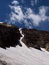
The Pipeline Couloir is a hidden couloir that ascends the north face of the American Fork Twins Peaks, ending just below the higher west summit. While hidden from most views, it is very prominent from Hidden Peak. I assume this couloir is named after a short line of pipe encountered at the top of the couloir.
This couloir, which ascends at about 42°-50° for 1,000 ft, is popular for ski mountaineers in the winter. According to Ice Climbing Utah, by Dave Black, it is also a popular mid to late summer snow climb or alpine ice climb, depending on timing. If you include the bowl below, it ascends for about 1,400 vertical feet.
Some things to note about this couloir - first, it is very narrow and there is a lot of loose rock at the top (mostly in the pebble to foot size), so watch out for moutain goats above, and stay out of the runnel as much as possible (although routefinding will require many crossings). Second, I found that it had formed moats almost continuously along its sides. Some of these were rather deep and all had snow that was much softer than in the rest of the couloir. Finally, the snow in the couloir seems to form cracks across the width of the couloir that require climbing over snow bridges or around the side near the rock. Once again, the snow here is likely to be much softer than the surrounding snow, and the cracks are often too deep to climb through.
Technically the couloirs in Utah don't have the altitude, steepness, and shading needed to retain year-round every year, but snow in these couloirs often last until late summer, when it has settled into harder neve with occasional spatterings of ice. That pretty well describes this route. The Ice Climbing Utah guidebook lists this as an AI 2 route. Personally, when I climbed it it was more like a neve climb - ice screws wouldn't have been very useful, but I often had to use the front points of my campons as steps couldn't be kick very deep.
 |  |
Approach
Park at the Snowbird Mountain Resort parking lot, just before the lodge.
Continue walking toward the lodge and walk across a bridge that forks off the road to the right. Follow the dirt road past two junctures (the second having a paved trail). Take the third juncture, which is marked as the Gad Valley trail.
Follow the trail as it enters the next drainage and meets up with another track. Go left and stay on this track as it switchbacks up the drainage, past a ski lift. Stay on trails, and always take the left option when the trail forks. Eventually you will start to enter a large bowl beneath the American Fork Twin Peaks (on the right) and Hidden Peak (on the left). The route begins here.
 |  |
Route Description
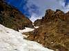
The Gad Valley Trail begins to splinter here. Take a trail that heads west (right) toward another bowl beneath the American Fork Twins. As you head this way, a hidden couloir will slowly come into view. After passing the base of a small ridge, cut across the next bowl toward the base of the couloir. The snow slopes here are about 30°-35°
The couloir is fairly narrow (about 15-20 ft wide) with vertical rocks on the sides. This requires you to constantly cross the runnel in the center as you find the best route up the chute. Once in the chute the angle increases. The snow is supposed to be around 42° in steepness when smooth, but later in the year as it develops depressions, it is mostly headwalls of 45°-50° with regular small easings of the slope.
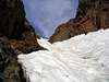
The couloir gets steeper as you climb higher, and several cracks in the snow may form across the couloir, requiring crossing snowbridges. Be mindful of soft snow around these and the moats lining the side of the couloir.
Don't be tempted to leave the couloir when the rock on the left becomes more broken. Stay in the chute all the way to the top, where you will exit either onto steep rock (left) or loose gravel (right) before reaching the very top. From here it is an easy class 2-3 scramble up a 50 ft headwall and then class 1 walking across the final 50 ft slope above to the summit. A snowfield often blocks this final slope for most of the year. This can be avoided by walking around it on class 1 slabs to the west.
 |  |  |
Essential Gear
Crampons, helmet, ice axe (possibly two). Some parties may want to use belays - in this case, pickets and flukes are more likely to be useful than ice screws. I wouldn't recommend making gear anchors on the rock as it is often loose and the couloir seems to form nasty moats along the edges.