
-
 29113 Hits
-
 79.04% Score
-
 10 Votes
|
|
Route |
|---|---|
|
|
48.43860°N / 121.0458°W |
|
|
Alpine traverse |
|
|
Most of a day |
|
|
Class 3, plus glacier |
|
|
Approach
The “Routes” of the Ptarmigan Traverse are the stages of this multi-day trek. Therefore, the approach to Stage 2 is Stage 1. Unless you hike the other direction.
Route Description
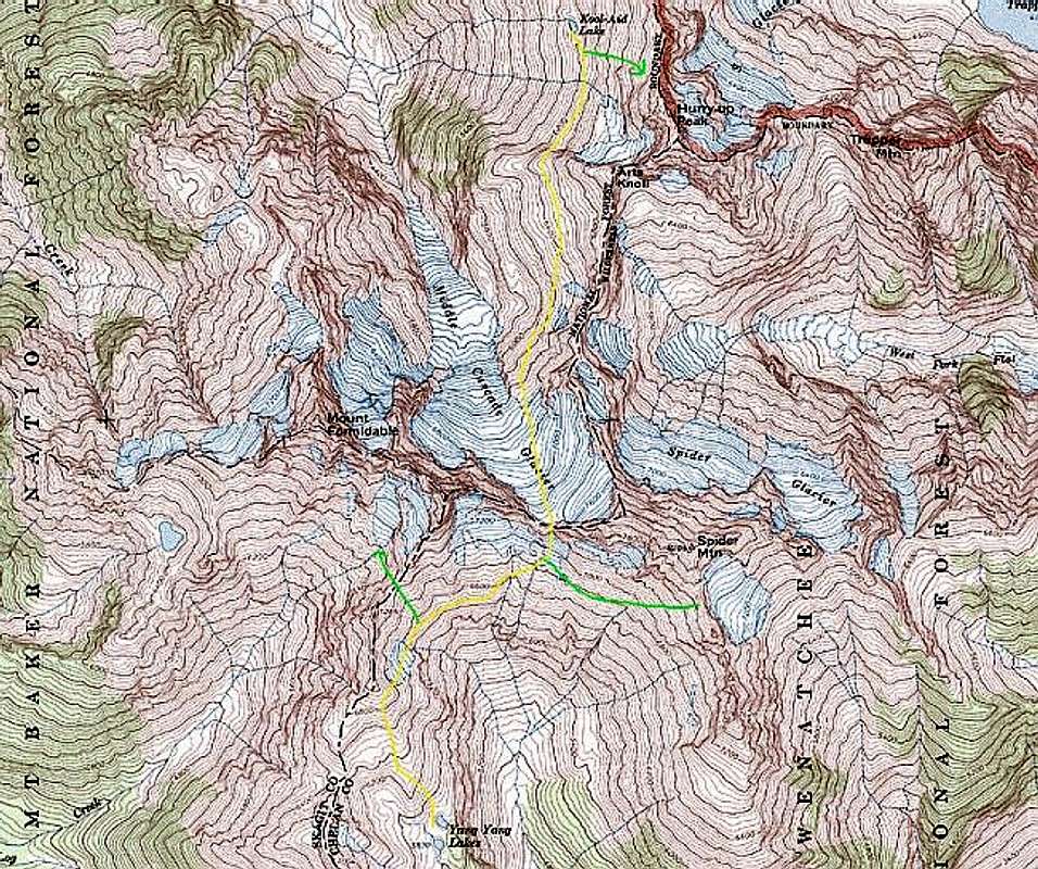 The second stage of the PT sidehills across the head of the Middle Fork Cascade River cirque, climbs glacier to the 7300' col between Spider Mountain and Mount Formidable, then drops into the Flat Creek drainage to traverse that cirque to the curiously-named Yang Yang Lakes. The few trees you encounter at the end are the first since before the Cache Glacier.
From Kool-Aid Lake traverse S (and detour immediately up to climb Hurry-up if you want). A half-mile S of the lake, the slope is blocked by a rock rib running down from Arts Knoll (7200'). Find the appropriately-named Red Ledge at about 6300' (elevation not checked) to pass the rib.
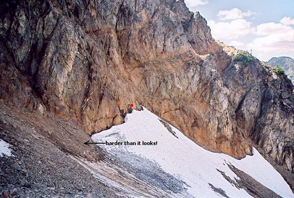
The Red Ledge. Click photo for larger version and more details from Klenke.
After the rib, continue traversing S, gradually dropping to about 5,900' to pass under a minor buttress 0.6 mile S of the Red Ledge.
 Traverse from the Red Ledge toward Middle Cascade Glacier
Stay low for a while, then ascend to reach the side of the Middle Cascade Glacier at about 6,600 feet. Rope up. Cross the upper glacier heading almost due S, climbing to Spider-Formidable Col at about 7,380' (map). These twin notches, dividing Spider Mountain from Mount Formidable, offer a choice. Beckey's guidebook advises passing through the right-hand (W) one. You'll descend bearing rightward to the minor glacier at the head of Flat Creek cirque. Our party was there in 1991, after a heavy-snow winter. We looked over the W notch, then chose the narrower E notch, finding perfect snow to plunge-step straight down to the same glacier.
[2008 addendum: So far, nobody has admitted to using the W notch that Beckey seems to recommend. It appears to have been a typo, corrected in later editions. Take the E notch.]
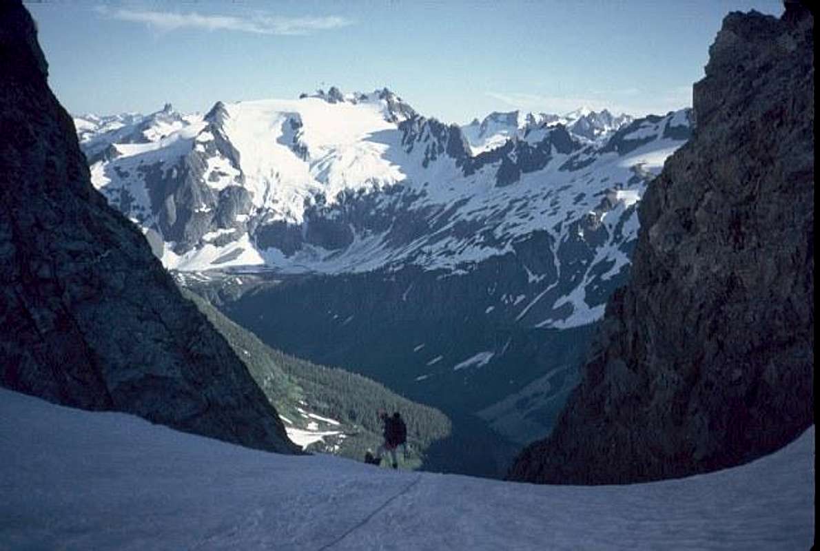
Starting down from E notch of Spider-Formidable Col.
The snow gully to the S was steep enough to give a couple of our party members pause; we had them lead their respective ropes, effectively giving them a top-rope. The slope angle eases at about 7,040'. Here are more choices:
To climb the standard route on Spider, head ESE here, toward the 7,860' saddle in Spider's S ridge.
We found a decent camp for two tents SW of the E notch, on a rock ledge at about 6,800'.
The standard route on Formidable is across the ridge 0.6 mi. W.
Otherwise, contour W and then S around Flat Creek cirque. It's probably easiest if you stay near 6,500' to the little glacier on the NE side of Point 7040+ (map), then climb the glacier diagonally to its upper edge at 6,800'. Traverse around the knob and descend S to the bench holding Yang Yang Lakes. It's been a long time since I was there, but the country is wide-open, so trust your eyes and judgment over my memory.
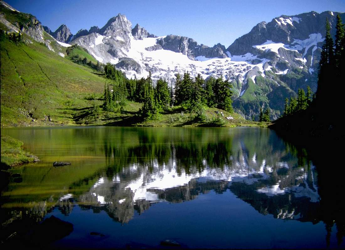
Across Upper Yang Yang Lake to Formidable (left) and Spider (right). The snow finger you descend between them is clearly visible. rfblolton photo.
 |  |
Essential Gear
See Ptarmigan Traverse main page.
Peaks to Tempt You
Hurry-up Peak (S Mountain), Art's Knoll, Spider Mountain, Mount Formidable.
Alternate Exits
Nothing easy. From the top of Formidable you can descend SW. The ridges fork a few times – pay close attention to your map. Follow the ridge crest toward the S Fork of the Cascade River to about 4,700' (in forest – see map). Descend moderately steep slope SSW toward Drop Creek. A trail crosses the creek at about 3,250 feet, 340 feet above the valley floor. Turn right. The trail downstream (N) climbs about 400' at first to avoid a box canyon, finally reaching the river about 1.1 miles (by map) N of Drop Creek.
The trail is not marked on the map, nor featured in any hiking guidebooks, but it's used by some guided groups and by glaciologists to reach the foot of the South Cascade Glacier. The two times I've been on it, it didn't appear to have been brushed out or maintained in any way, except by boots. Though you can tell where the trail goes if you pay attention, you may not see your feet for significant stretches of it, being in brush up to your shoulders. At one point a fallen tree provides a highway for 120 feet or more, 8 feet off the ground, which is invisible below vine maples. If it's raining or dewy, plan on getting drenched.
Bob Bolton - Dec 18, 2005 7:17 pm - Voted 10/10
Route CommentClick on the thumbnail for a Google Earth view of Stage 2, with annotations. Please note that Stage 2 begins at Kool Aid Lake and leads up the Middle Cascade Glacier over Spider-Formidable Col, which is the starting point of this image. See the Google Earth view of Stage 1 for the first part of this stage.

willow - Aug 3, 2006 11:39 pm - Hasn't voted
Spider - Formidable ColConcerning the detail that Beckey says you take the West notch through the Spider-Formidable Col. My friends had an older Beckey guide (I regret that I don't remember the year it was published) and in it he says to take the East notch and go down the snow. The west notch pretty much cliffs out as far as I can tell. I probed it but it was pretty loose, ugle and steep. At the east notch the snow is a little steep but there was a pretty good run out at the bottom when we did it and it felt totally safe (like you we belayed a couple of uncomfortable parnters). I submitted a picture showing the south face of the col, so people can see what the west and east notches look like.
Aaron Dyer - Jun 1, 2009 11:54 pm - Hasn't voted
Re: Spider - Formidable ColI concur. I am looking at the 1977 first edition, and in it, Beckey states: "Then ascend the glacier to Spider-Formidable col (7320+); the correct col is 100 yds E of the most obvious one. Descend snow on S slope, then bear W."