
-
 6263 Hits
-
 0% Score
-
 0 Votes
|
|
Route |
|---|---|
|
|
36.55000°N / 4.927°W |
|
|
Scrambles combined with Technical Rock Climb |
|
|
Most of a day |
|
|
5a (french grade) max. (mostly 3rd grade) |
|
|
Introduction
Due to its distance from La Concha range and its excellent climbing possibilities, this route could be, without any problem, a separate mountain log at itself. Nevertheless, I have decided to include this ridges traverse under La Concha page, as a route, because its relative proximity to this summit and because it shares many of the headings with its neighbouring mountain (like ‘getting there’, ‘cartography’, ‘overview’, etc…). This does not mean that, after have studied all its potential, or at the request of other SP members, it will become in the future a Mountain Log by itself, separated from that one of La Concha.
 |  |  |
General Information
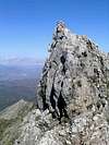
Los Cuchillos range (pronounced [koochiyos]) is an impressive limestone rocky wall, the spine of ‘Sierra Canucha’, a range of peaks rising over the 1.200 metres just four kilometres to the NE of La Concha’s summit. To situate the whole system of sierras you can consult the sketch of the area . It is an area just outside the perimeter of the “Parque Natural Sierra de las Nieves”, but yes included in the Biosphere’s Reservoir area, having the same status as La Concha has.
Despite the extensive network of paths crossing the mountain around it, Los Cuchillos is not a popular area due to the exposed and airy of its peaks. In fact “Los Cuchillos” means ‘knives’ in Spanish. This gives an idea of the difficulty of the terrain, with sharp narrow ridges (like knives…) with drops to both sides. There are many technical passes on its traverse and the rock is not always so stable as it might look like. On the other hand, this network of paths makes the rage easy and quickly to access from the Mountain Hut of Juanar or from the village of Monda, and, therefore, still a comfortable area to reach from the well known Costa del Sol. It becomes, this way, the adventurous alternative to the mass tourism of sun and golf.
 |
Getting there
In order to reach Los Cuchillos range one has to go to the Refugio de Juanar, a hut converted in a three stars hotel. To read about how to reach this hotel, please go to La Concha-Normal Route (NO slopes) and look at “Approach” section.
An ascend from the village of Monda (to the NE) is also possible. This mountain village can be reached following the road A-355, from Marbella to Coín. This approach is much longer than from Refugio de Juanar and I will not explain it here.
In fact, the shortest approach is from the trailhead starting at Km. 4 of the road to Ref. de Juanar (MA-469): Approximately 600 mtrs before the end of the road (which finishes at the Refugio de Juanar) there is a sign to both sides of the road marking the place of the trail. We can park the car there and take the path at the right (direction Ref. de Juanar), which goes, firstly, down the hill. The path that starts here is a well stepped trail, that, after an initial descend, it climbs along the mountain side direction a saddle at 920 m. high.
This path is a circular trail which, eventually, will reach the Ref. de Juanar, passing very close to Sierra de Canucha and Los Cuchillos. Those ones starting at the Ref. de Juanar itself will reach this place too after 3 hours walking.
Approach
Once have reached the saddle at 920 m (“Alto de la Playera” in some maps), the path walks into a small gorge, ascending with the (dry) river bed to the right. We are walking on the green north slopes of a hill and there are many Mediterranean bushes and holm-oaks of all the sizes everywhere. We will reach a fountain (dry?) with a drinking basin for cattle after half hour from the car parking place. Five minutes later we are on a pass (at 1.080 m high). The path is flanked by two big pine-trees. This spot can be easily reached from the Ref. de Juanar as well. In fact, from this path we can see how the path continues traversing the hills direction Juanar hut. At this point we will have to leave the well marked trail to ascend to Los Cuchillos: Looking to the N there will be a big light grey rocky promontory (coming from Juanar hut it will be to our left hand, and coming from the Km 4 at the MA-469 road it will be right of us). We follow a tiny path that ascends towards that rocks. There will be some bushes narrowing the path, but after some minutes we are just in front of the grey rock.
We could start our scramble here and climb directly up to this rock (an easy french 3rd grade) but I advise to leave it and continue on a track that surrounds the rocks, now to our right hand. After five minutes we are on a saddle with views on all the ridge (right hand), and, like a miracle, a hidden “Pinsapo-tree” forest down in the valley.
After have been enjoying these beautiful views, we can focus on the ridge waiting in front of us: two thousand metres of naked rock of which more than the half offer very exposed and delicate passes on the edge of straight down walls.
Route Description
Starting at the saddle, at 1.175 m, a short ‘scrambly’ rocky ridge to the east brings us to the highest point of the ridge: the “Picacho de Castillejos” (1.222 m). A stone’s pile marks this first summit, from where we can study the more difficult terrain ahead. We descend over the easy but what narrower ridge (NE direction) till a grassy saddle.
In front of us rises the first serious difficulty: a seven metres high tower keeps the entrance to the most difficult sections of the ridge. Harness, rope and the rest of the climbing hardware is highly recommended: the tower itself could be a 4th (french) grade. Belaying and self-protection can be tricky. To make things better, the rock can be a little bit decomposed here and there.
After the tower we will be on the top of a rocky ‘knife’, so sharp and narrow that does not leave the option to traverse on it, having to be negotiated on its left side. The edge can be well used like a good hands’ hold.
The rest of the route description will come soon. I still have to go back there, with the right equipment, and try to find out how to continue it. I only can say that, there are, at least, two more knife-sharp stony edges with almost vertical drops to both sides. I have even seen an overhang wall to the E. Here and there, the ridge gives up temporarily with a kind herbaceous saddle, perfect spots for a quiet break.
 |
Essential Gear
Being an scrambling route with many technical rocky passes on a not always stable limestone rock, I advise:
- a single rope of 10,5 mm (40 metres is more than enough).
- harness.
- helmet.
- abseil device.
- 4 express sets (snapper with band) for self-protection.
- two HMS karabiners.
- what bigger friends and nuts.
- 2 band slinges.
- short prusik rope (for abseil back-up).
This route can be best walked on flexible trekking shoes (special climbing shoes are not needed, neither recommended).
Next to that, standard backpack filling (warm clothes, food, compass, map, first-aid kit,...), with special mention to plenty of water, and sun protection (cap, suncream, sunglasses). Los Cuchillos can become quite warm, especially during the hot summer months.
Extra Information
For extra information, like cartography, weather, when to climb, etc..., please check the La Concha Mountain's Main Page.