November 7
Having never been on a Colorado Hut Trip, it seemed like it would be a good adventure for my six year old son Kessler and I. The plan was to snowshoe to and stay in the 10th Mountain Division Hut and climb Shrine Mountain (to the pinnacle) and Point 11977 to the south. The weather forecast was good and we headed off to Vail Pass. The plan was to start in the morning, but things came up and we didn’t start until early afternoon. Three others were to join us at the hut.
With recent snowstorms, the snow is just deep enough to use snowshoes. Finding the route to the cabin was actually quite the adventure because we found the route was not marked for winter use yet and there was light snow, but very low visibility and heavy fog. So much for a good weather forecast. There was a sign at the trailhead that said to follow the blue trail markers. After a few hundred yards we noticed all the blue trail markers leaning up against a tree. Interesting. Apparently the trail markers are removed in the summer so we would have to do without. We lost the trail several times and got caught in some willows and had to bushwhack several times in the willows. Since visibility was so low the map didn’t do us much good and we eventually found ourselves in the middle of a huge sea of willows and soft snow. I pulled out the map and made the decision that we would scrap trying to find the trail and head due north up the steep slopes to the snowmobile track heading to Shrine Pass. It would be a long detour and out of the way but we couldn’t see much and I thought at least we would know where we were at all times if we found the track.
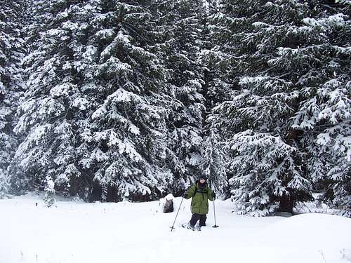
![Trail Breaking]() Trail breaking on Shrine Mountain.
Trail breaking on Shrine Mountain.
Kessler and I grinded up the long steep slopes while route finding through the trees until we found the track. Once on it we headed west and made good time to Shrine Pass. We erroneously took the Shrine Ridge Trail to for a short distance since the Trails Illustrated Map shows Chucks Cabin in the wrong place and shows is several hundred feet too low! It was getting pretty dark, but we returned to Shrine Pass and luckily there is a map posted on a board at Shrine Pass showing the correct location of the cabin. We now knew we should go through the gate to the north to find the cabin. Visibility improved before sunset and we reached the cabin at 11,209 feet just as it was getting dark.
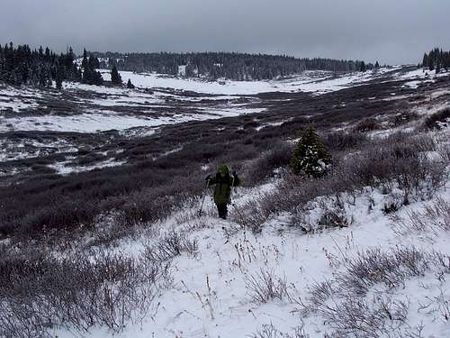
![Getting dark]() Kessler on our route to the Shrine Mountain Cabins, November 7. Weather and visibility improved at sunset, but then we were rushed to find the cabin by dark.
Kessler on our route to the Shrine Mountain Cabins, November 7. Weather and visibility improved at sunset, but then we were rushed to find the cabin by dark.
We both went inside of the comfortable cabin for some nice relaxing time before going to bed. After cooking and eating a good dinner, we talked a long time about all the things on a six year olds mind concerning life. Kessler thanked me for bringing him to the mountains and expressed what a good time he was having. After that, I read and Kessler played with the toy dinosaur he had brought.
We waited and waited for the others until it was time to go to bed. One of the other people who were supposed to be coming told me that she might be having car trouble and might not be able to make it. Where were the other two though? I had just talked to them in the morning and they said they were coming. I hoped they were OK and were just running late. We settled down for a long night’s sleep.
![Chuck s Cabin]() Chuck's Cabin located at 11,209 feet on Shrine Mountain is where we spent the night.
Chuck's Cabin located at 11,209 feet on Shrine Mountain is where we spent the night.November 8
No one else had shown up in the morning. I assumed they just couldn’t make it for some reason or changed their mind about coming. In the morning it was still snowing (it snowed the whole time even thought the weather forecast was good!) and visibility was still very low so we decided to forgo attempting Shine Mountain and surrounding peaks. We decided to hike the peak north of Shrine Pass instead. We headed north and back down to Shrine Pass before heading north to attempt the peak. The clouds momentarily lifted and we got to the summit area but were blocked by fallen timber and returned since visibility dropped really low again. I assume we were very close to the summit of the peak. We headed back to Shrine Pass to head out and for home.
![Shrine Mountain Attempt]() Heading back after our attempt of Shrine Mountain.
Heading back after our attempt of Shrine Mountain.
Instead of following yesterday’s route, we broke another trail back down into the valley. Kessler took his turn and enjoyed breaking the trail in some areas. We actually crossed the frozen creek several times before climbing to and staying high on the north slopes a few hundred above the creek. I had assumed that we would eventually cross yesterday’s trail that we broke up the steep slope. Somehow we missed the trail (the wind must have covered it) but visibility was pretty good and it was no problem finding a good route. We stayed high until dropping down to the valley right when we were near Vail Pass. It was a great trip and we headed for home. Kessler thanked me for taking him on such a great adventure. The only disappointment was that because of low visibility we never did get a good view of all the surrounding mountains.
![Shrine Mountain]() The visibility and weather improved in the morning enough so that we could actually see Shrine Mountain. The visibility didn't last so long though and the mountains soon disappeared. Keep in mind also that the weather forecast was for sunny skies. They really botched this one!
The visibility and weather improved in the morning enough so that we could actually see Shrine Mountain. The visibility didn't last so long though and the mountains soon disappeared. Keep in mind also that the weather forecast was for sunny skies. They really botched this one!![Emerging from Bushwhack]() Kessler is just emerging from the first of our bushwhacks on the return from Shrine Mountain.
Kessler is just emerging from the first of our bushwhacks on the return from Shrine Mountain.
Note: After getting home we had learned that the other two people that we waited for in the cabin did indeed attempt to reach it. They left not too long after we did and they found and followed our trail. After passing through several sections of willows they lost our trail in the big willow patch mentioned above where we headed north for the snowmobile track. They didn’t know we headed north and since our trail appeared to end they thought we must have given up and turned back. They turned back reaching the trailhead after dark and headed for home.


Comments
Post a Comment