
-
 1509 Hits
-
 71.06% Score
-
 1 Votes
|
|
Route |
|---|---|
|
|
42.25724°N / 7.29818°W |
|
|
Download GPX » View Route on Map |
|
|
Less than two hours |
|
|
walk-up |
|
|
Overview
It's the shorter and most popular route (well, the climb by car is shortest but it's a not a hiking route). Map of ski resort
Getting There
See main page.Route Description
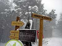 start
start signal
 paint
paint paint
paintThe route changes if the summit is covered with snow or not and if the ski resort is open for skiers.
In summer you walk among the lift area (1,500 m) and you can walk on the grassy slopes ranging shortcutting tracks without any problems. With snow and poor visibility is recommended from the parking back a few meters to enter the track on the left, which indicates start of the route (comenzo do ruteiro). Following marks P.R. (yellow and white) performing multiple loops after passing through the shelter called Roteiro Manzaneda. The tracks is enabled especially for mountain biking. It traverses the slopes and ski lift piers, provided by track, until finally reach the summit plateau and the antennas. Turning left (SE) is the geodesic which is the top. It is supposed to step on the track is prohibited on the opening for skiers, so I guess you can not make the path marked out in that case.