"Sometimes I feel sorry for the river..."
"Sometimes I feel sorry for the river. It works every second
of the ages carving away at the rocks and digging its canyons.
It carries a million tons of silt a day. And again, I feel sorry
for the mountains with the river gnawing at their inside,
but I guess my sympathy doesn't seem very important to either
of them."
- Buzz Holmstrom, legendary Southwest river man (1937)
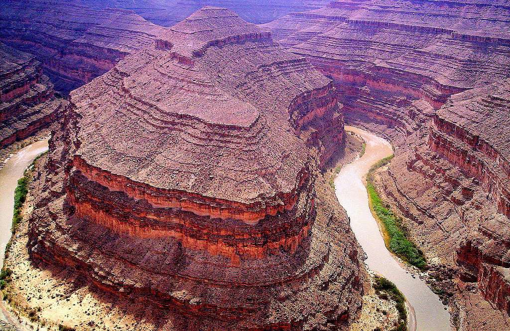
Paradox - The Passing of Time at 'Goosenecks:'
Around the small (it takes a village) of Mexican Hat in
SE Utah, the San Juan River is slow-moving and flows through
a relatively shallow red rock canyon with many wide curves;
more of these convolutions can be seen in the nearby
Goosenecks State Park, reached by a 4-mile paved road
(UT 316) that branches off UT 261 a little way north of town.
The state park, to which entry is free, has just one extended
viewpoint of several HUGE river bends, now flowing (approximately)
1,000 ft (305 m) below ground level in a DEEP canyon with a
series of stepped cliffs & terraces, a feature recognized
as one of the best examples of entrenched meanders
in the world.
At the park, the waters flow through 5 miles of canyon
whilst progressing westwards only one mile. Beyond the
visible meanders, the river continues to twist & turn
as the canyon deepens, before joining Lake Powell after
about 35 miles.
(Yes, a bit like "TWISTED SISTER.")
Geology:
The river originates in the San Juan Mountains of Colorado, and many
millions of years ago flowed gently across a flat landscape, forming
LARGE meanders that frequenty changed position.Uplift associated with
the creation of the Colorado Plateau caused the river (gradually) to
become entrenched, PRESERVING the most recent course in the deep canyons seen today.
The rocks forming the sides of gorge are shale and limestone from the
Paradox Formation and the Honaker Trail Formation, up to 300 million
years old.
Approximate elevations (your readings may vary):
Peak in the foreground: 4,953'
Park's overlook elevation: 4,980'
Elevation of the river: 4,100'
April 26, 2009


Comments
Post a Comment