
-
 4882 Hits
-
 90.48% Score
-
 32 Votes
|
|
Route |
|---|---|
|
|
41.93110°N / 111.6541°W |
|
|
Hiking, Scrambling |
|
|
Spring, Summer, Fall |
|
|
Most of a day |
|
|
Class 2 |
|
|
Overview
This is the shortest route to the summit of Mount Gog. This trail goes over a ridge overlooking the valley. You must climb back up this on the return trip. It is a nice four mile hike to White Pine Lake. The lake is located in a nice setting below the vertical walls between Mount Gog and Mount Magog. The route climbs up the Southwest Ridge of Mount Gog. This is located to the left of the large south face. The summit is located on top of limestone cliffs. There are great views of all of the highest peaks in the range. I recommend climbing Mount Gog if you are in the area near Naomi Peak or White Pine Lake.
Getting There
Drive on I-15 north of Brigham City and take exit 362 (US-91/Logan). Keep driving on US-91 through Sardine Canyon. After 25 miles US-91 will merge into Main Street in Logan. Drive to the intersection of Main Street and 400 North in Logan. Turn east on Hwy 89 into Logan Canyon. Drive for about 18 miles to the exit to Tony Grove. Turn here and follow this paved road for 7 miles to the trailhead and also the parking lot for Tony Grove Lake.
If coming from the east near the cities of Soda Springs or Montpelier. Turn onto Highway 89 and drive south toward Garden City which is on the east side of the range near Bear Lake. Drive up the switchbacks into Logan Canyon. Go over the summit of the canyon and then drive to the road junction to Tony Grove. Drive down this paved road for 7 miles to the trailhead.
Approach
 White Pine Lake
The trail starts near the kiosk by the parking area. Hike up the trail until you get to a junction. The trail on the left goes toward Naomi Peak and the other goes toward White Pine Lake. Take the trail to White Pine Lake. The trail goes through a large meadow below Mount Magog. Then there is an unsigned and faint junction. The trail sign was broken and knocked over when I was there. Just continue on the main trail that goes around the hillside. The route then follows White Pine Creek along the canyon.
The trail climbs up to a small saddle on the ridge ahead. From the top of the ridge, you should get your first view of Mount Gog across the canyon. The trail then loses about 400 feet of elevation down a series of switchbacks as it goes toward White Pine Lake which isn’t visible yet. Mount Magog comes into view above the trail. There are a few stream crossings with some foot bridges before you get to the lake which is set in a cirque below limestone cliffs. White Pine Lake is located at these coordinates: (41° 55' 23" N, 111° 39' 18" W).
Route Description
 Southwest Ridge
 Southwest Ridge
From White Pine Lake start hiking toward the southwest ridge of Mount Gog. This is the tree covered ridge that is located to the west of the south face cliffs. Leave the trail where there are several campsites used by horses and campers. Hike up the mountainside which is rated class 2 but is steep in a few places. Route finding along the ridge is straightforward. There are trees and rock outcroppings that you must climb over. There was a nice game trail higher on the route. Expect some loose rock on this slope.
 South Face
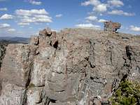 Summit
Depending on how directly you follow the ridge, there will be a large cliff band right below the top. It requires 5th class climbing to climb over the top of it. You can hike around it on either side. I went around the west side and then easily climbed up to the summit ridge. You will have to hike east to get to the actual summit which is located on a long limestone plateau. The highpoint has an interesting square block that sits alone on a flat summit ridge. I found a small cairn sitting on it. Elevation gain from White Pine Lake to the summit of Mount Gog is 1,400 feet.
The summit view includes the highest mountains in the range. Naomi Peak can be seen to the south. Bullen Hole Peak and Cherry Peak are to the southwest. From this angle, Cherry Peak resembles a shark tooth. The most impressive mountain that can be seen from the summit is Mount Magog to the southeast. It looks like a fortress surrounded by steep cliffs above White Pine Lake. Doubletop Mountain can be easily identified to the north with its twin summits. Cache Valley and even Oxford Peak in the Bannock Range can be seen to the west.
Distance from the trailhead to the summit via the Southwest Ridge is 5 miles and Elevation Gain is 2,650 feet
Descent
The descent down the southwest ridge will go back to White Pine Canyon. If you decide to traverse over to Naomi Peak or Mount Magog, the easiest descent is to hike down the Naomi Peak trail. Both trails start from Tony Grove Trailhead so a car shuttle is not needed.
1) The standard descent is back down the southwest ridge. Remember to hike to the west side of the summit ridge before descending. The hike has some elevation gain up to the saddle overlooking White Pine Canyon on the way back.
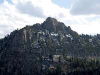 Magog seen from Gog
2) Gog to Naomi Traverse: This route traverses the ridge between the two summits. It can also be done in the opposite direction from Magog to Gog. From the summit of Mount Gog, you will notice the long ridge that is to the west. The ridge is entirely off trail and is rated class 2. You will loose some elevation down climbing the west ridge of Mount Gog. It goes west toward the ridge that is located south of Bullen Hole Peak and then toward Peak 9,350. The ridge will eventually get to the saddle that is north of Naomi Peak which will be a short distance away.
3) Gog to Magog Traverse: The most direct route from Mount Gog to Mount Magog is the lower elevation ridge above the cliffs near White Pine Lake. The ridge itself is short distance with good views. The face below Mount Magog requires some 3rd class scrambling to find the easiest route through the cliff bands on the northwest side of the mountain. The best route up Mount Magog is from the south. Follow the ridge through short rock walls and trees. The summit is located among several large boulders.
Essential Gear
Mount Gog is usually climbed in the spring, summer, and fall season. During this time, you will need the ten essentials and basic day hiking gear. Food and water. Hiking boots for off trail hiking and scrambling. Bring a Topo map for this hike.
Logan Canyon is plowed in winter but the road to Tony Grove is not. Snowmobiles pack down the road to the trailhead. It would be a long distance to climb Mount Gog in winter so this is rarely done.