
-
 7473 Hits
-
 84.15% Score
-
 18 Votes
|
|
Mountain/Rock |
|---|---|
|
|
49.19691°N / 7.87368°E |
|
|
Hiking, Sport Climbing, Scrambling |
|
|
Spring, Summer, Fall |
|
|
1217 ft / 371 m |
|
|
Overview
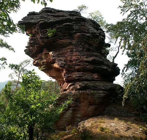
 Spirkelbacher Rauhles with Otto Wendel Turm Spirkelbacher Rauhles with Otto Wendel Turm |
Like neighbouring Wilgartswiser Rauhberg Spirkelbacher Rauhberg (also Kleiner Rauhberg) is a small mountain with three impressive sandstone cliffs. Here the cliffs stand out in three of the compass directions - north, west and south - and are joined right on top of the mountain. The northern cliff is Krappenfels, a small and overhanging rock, very short and about 30m in height. Its summit can be reached via a UIAA I climb which is facilitated by the roots and stemms of the dwarf pines which grow out of its cracks. The southern crag is called (Spirkelbacher) Rauhbergpfeiler. It protrudes out of the Rauhberg slopes by about 100m and reaches a hight of about 40m. Here the easiest route is the stroll along a marked hiking trail onto the summit.
The real show about Spirkelbacher Rauhberg, however, is the central cliff, (called Spirkelbacher Rauhfels) which runs from the summit towards the west. It is a long (several 100m) ridge which drops away to both sides for about 50m. The ridge is broken into several parts, the upper ridge near the Rauhberg summit, a main summit (which is a wide tower and Otto Wendel Turm right at the end of the cliff. The upper ridge can be reached via a ledge from the Rauhberg summit, the main summit is accessible from another ledge which starts between it and the upper ridge and Otto Wendel Turm is a real climbing destination.
As mentioned above, there is a regular marked hiking trail, which runs along Spirkelbacher Rauhfels, always beneath the south face of the main cliff. It runs through a tunnel-like rock window before it turns to meet the Rauhbergpfeiler summit. Later it turns around the main summit to head for Krappenfels in the north. Thus all three cliffs can be easily reached from any of the villages of Hauenstein, Spirkelbach and Wilgartswiesen (which are almost equally far away from the rocks.
|


Climbing Routes on Spirkelbacher Rauhfels
 Krappenfels
The climbing history on Rauhfels starts in 1905, when August Bauer, Karl Petry and Friedrich Jung establish the normal route to the main summit. Today you can find many routes on all three cliffs, the most obviously on central Rauhfels.
The following information is linked from the site of the Vereinigung Pfälzer Kletterer I link to their routes database directly with some summary info. Here is the link to the complete database.
| Region | Routes link | Summary |
| Spirkelbacher Rauhfels | Rauhfels | 46 routes with variations ranging from 1 - 9/ |
| Otto Wendel Turm | Otto Wendel Turm | 3 routes with variations ranging 3 - 6- |
| Spirkelbacher Krappenfels | Krappenfels | 4 routes with a variation ranging from 1 - 4+ |
Getting There
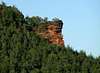
 Spirkelbacher Rauhberg
The cliffs on Spirkelbacher Rauhberg can be reached from the villages Hauenstein, Spirkelbach and Wilgartswiesen. All can be reached from te main highway B10, exit Wilgartswiesen. Follow the signs to the respective villages once you are in the centre of Wilgartswiesen.
The closest airports are at Frankfurt and Stuttgart so the itineraries start there too.
From Frankfurt
There are two possible routes which both take equally long- Via Ludwigshafen
- From Frankfurt take motorway A5 southward to Darmstadt.
- There change to A67 south.
- At Viernheimer Dreieck turn onto A6 west. Leav
- e it at Frankenthaler Kreuz for A61 south.
- At Mutterstädter Kreuz take A65 south until you reach Landau.
- At Landau turn on B10 west.
- Leave B10 at Wilgartswiesen and drive into the village
- Right in the center K54 turns off south in the direction of Spirkelbach, a little later K38 leaves for Hauenstein
- Via Kaiserslautern
- From Frankfurt take motorway A3 west
- At Mönchhofdreieck turn onto A67 south
- At Rüsselsheimer Dreieck take A60 west
- At Kreuz Mainz Süd take A63 south
- At Kreuz Kaiserslautern turn onto A6 west
- At Kreuz Landstuhl turn onto A62 south
- At Pirmasens turn onto B10 east
- At Wilgartswiesen turn off and follow the instructions above
From Stuttgart
- Take motorway A8 to Karlsruhe
- At Karlsruher Dreieck turn north onto A5
- Tke the next exit to head for A65
- At Landau North turn to B10
- Rest as above
|


Red Tape
 Honeycomb erosion structures
Yes, there is red tape and lots of it. The sandstone of Südpfalz forms lots of caves and overhangs. Though this makes it most interesting for climbers, two species of birds of prey compete for this habitat: the peregrine falcons and the eagle owls. Both are endangered and wherever there is a eagle owl pair found nesting in the sandstone the crag will immediately be closed. Generally this closure lasts from the beginning of each year through Aug. 1st. If breeding is not successful the closures will be cancelled even before that date. For a list of closures see the Closure List of PK.
The use of magnesia is not allowed in the whole Südpfalz region. This is rather a directive or an arrangement than an outright law. Thus you probably will get away with using it but do so only when absolutely necessary. Magnesia closes the pores which you find in the sandstone and together they form a smooth surface which will get very slippery in wet conditions. The rule of thumb is to use magnesia in the highest difficulty sections and only extremely sparingly.
A list of guidelines can be found here (in German).
Accommodation
You can find hotels and apartments in Wilgartswiesen or neighbouring Rinnthal and Hauenstein. Have a look at the following links (which are in German, however):- Wilgartswiesen information
- Trifelsland information
- Hauenstein Pfalz information
- Hauenstein information
- Rinnthal information
Weather Conditions
Wilgartswiesen has its own weather forecast at wetter.de, Hauenstein on weather.com:Maps & Books
Maps
As for maps there is a good overview map (1:50000) by Kompass Verlag but the best ones are the official topographic maps by the state government of Rheinland Pfalz, scaled 1:50000, 1:25000 and 1:5000. All official maps can be found on the web page of Landesvermessungsamt Rheinland Pfalz
1:50000
- Naturpark Pfälzer Wald
Kompass Map WK766
ISBN: 3-85491-523-3
- Annweiler am Trifels
LVA RLP Map L6712
ISBN: 3-89637-191-6
1:25000
- Annweiler am Trifels
LVA RLP Map 6713
ISBN: 3-89637-141-X
Books
There are a number of climbing guidebooks on the region of Südpfalz. The best ones, however, have been published privately and are sold only in selected bookshops of the region.
- Hiking
- Pfälzerwald
B. & J.-Th. Titz
Rother Verlag
ISBN: 3-7633-4268-0 - Klettern im Buntsandstein
U. Daigger, H.-J. Cron
Published privately and out of print
- Pfalz ++, Klettern im Buntsandstein
R. Burkard, P. Weinrich
Published privately
- Klettern im Naturpark Pfälzerwald
Naturfreunde Lambrecht
Published privately - Pfalz & Nordvogesen en bloc
A. Wenner, Y. Corby, I. Bald
Panico Verlag
ISBN: 3-936740-19-4
Climbing