
-
 30200 Hits
-
 89.35% Score
-
 29 Votes
|
|
Route |
|---|---|
|
|
43.74110°N / 110.802°W |
|
|
Mountaineering, Ice Climbing, Mixed |
|
|
Spring, Summer, Fall |
|
|
One to two days |
|
|
5.7 (YDS) |
|
|
Mixed rock, snow, and ice |
|
|
6 |
|
|
III |
|
|
Overview
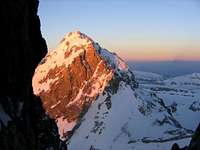 Middle Teton from the Stettner Couloir
 Ice Steps
The Stettner Couloir is one of the less frequently climbed routes on the south aspect of the Grand Teton. The couloir is an enjoyable alternative to the much more popular routes on the mountain, and offers a variety of mixed climbing problems involving rock, snow, and ice. During spring and early summer the route will be largely a snow and ice climb, whereas in later summer and autumn the route will probably involve mostly rock.
The couloir lies between the Petzoldt Ridge on the left and the Underhill Ridge on the right, topping out at a col behind the Underhill Ridge, from which point the upper southeast slopes of the peak can be climbed to the summit.
The first ascent of the Stettner Couloir as a snow route was by Charles Schaeffer, Bob Schaeffer, Mark Fielding, and Curtis Stout, on June 30, 1964, while the first ascent as a rock route was by Leigh Ortenburger and Jennifer Ronsiek, on August 17, 1969.
With a very early start strong hikers may be able to complete the route in one long day, but a more realistic itinerary may be to spread the hike over 2 days, with a camp in Garnet Canyon. This will require a backcountry camping permit, available free of charge at the Jenny Lake Ranger Station. Refer to the Grand Teton camping guide for complete details on camping in the park.
Getting There
From the Lupine Meadows trailhead follow the popular and well used trail for ±3 miles to a trail junction. Here the trail splits, with the right branch continuing on to Amphitheater Lake. Take the left branch and follow the trail as it continues into Garnet Canyon.For those making the climb as a multi-day trip, common camping spots are located at (in order reached) the Meadows, the Caves, the Moraines, and the Lower Saddle. The Meadows area will require the longest summit day, with the other sites involving progressively shorter summit days but correspondingly longer and more strenuous approach days.
Route Description
 Above the "ice steps"
Note on route conditions: This route description is based on a Spring ascent, when the couloir was primarily a snow and ice climb. Expect considerably different conditions if climbing the route later in Summer or Autumn.
I have received several e-mails indicating a considerable amount of rockfall in the couloir during mid and late season. Evaluate conditions carefully if climbing during these periods.
 Upper Couloir
From the Lower Saddle make a long traverse north, then east, following the approximate path shown in this photo, passing under the base of the Lower Exum, and then the Petzoldt Ridge. After passing the base of the Petzoldt Ridge veer left and begin ascending the snow slope as it enters the couloir.
 Looking Down from the "Cave"
The lower portion of the couloir is of moderate steepness, so the decision on where/when to rope up will depend on the comfort level of the party. The couloir gradually steepens then reaches a pitch consisting of a series of short (±6 foot) ice steps.
 Approaching the Col
Above the ice steps is another snow slope of moderate steepness, which may be belayed or free climbed. The angle increases again until an established anchor (2 pitons) is reached near the left side of the couloir. Belay at the anchor and proceed up a narrow section of 5.5 rock on the left, or ice/snow on the right, before opening up on a steep snow apron which leads to an overhanging 'cave'.
 Looking Down the Couloir
In early season a ±30 foot ice column may form up to the left of the cave (which has been climbed as a WI4+ ice climb). From the cave climb up and right on rock for a very short pitch to a large covered ledge, moving the belay up to this ledge to prevent significant rope drag.
 Upper Slopes and Summit
The exit from this ledge to the slopes above is the crux of the couloir, and involves a 6-foot traverse across a sloping slab under a low flaring roof. A #3 Camalot protects this move, which may be complicated by verglass on the slab.
 Approaching the Summit
Above the crux ascend moderate snow for ±100 feet to the col at the top of the couloir, and just behind (north) of the Underhill Ridge. From the col the view opens up to the east, with the Second Tower and East Ridge visible on the right, and the summit of the Grand just visible directly to the north.
Begin ascending the steep southeast slopes towards the summit, which will turn out to be further than it appears. The exact path to follow will vary depending on snow conditions and the amount of snow and/or rock present, as well as the preferences of the climbing party, but there are no real difficulties to speak of.
The seemingly eternal snowfield ends at the base of the summit block, where a short easy scramble up and to the right (east) leads to the summit.
Descent
The most common and easiest descent of the Grand Teton is made by reversing the Owen-Spalding Route. Refer to the Owen-Spalding standard route and the Owen-Spalding chimney variation route descriptions for details on descending from the peak.Essential Gear
For climbs later in the season more rock gear will probably be required, while the ice gear could probably be reduced or eliminated.