
|
|
Mountain/Rock |
|---|---|
|
|
4.06181°S / 137.18529°E |
|
|
Mountaineering |
|
|
Spring, Summer, Fall, Winter |
|
|
15978 ft / 4870 m |
|
|
Overview
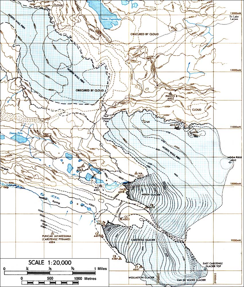
Sumantri (also spelled Soemantri) is a splendid sharp summit approximately 2 kilometers north of Carstensz Pyramid in Papua. The north side of the peak is dominated by tremendous cliffs that wrap around onto both the eastern and western sides of the mountain. Remnants of the once mighty North Wall Firn still cling tenuously to the southern aspects of the peak. It is unlikely that this ice will last for more than the next fifteen years or so...There is considerable variability and confusion in the names associated with the peaks in this region. The peak of this page is currently the highest peak along the North Wall Firn, the largest glacial remnant in the Carstensz area. As such, it is possibly also the peak that is listed as Ngga Pulu on page 47 of Heinrich Harrer's I Come From the Stone Age. Click here for an online copy of this map. Many maps and sources apply this name to the shorter flatter topped summit slightly to the East of Sumantri, a peak also called Puncak Jaya by most of the locals. It is possible that this shorter peak was taller when the summits of these peaks were snow. Currently, the top extent of the glacial ice is now lower than the rock summits, so the ordering of the summits might have changed due to this melting.
 Sumantri (left) from the slopes of Carstensz Pyramid, June, 2010.
Ngga Pulu was first climbed by the Dutch in the 1930s, so it is possible that they made the first ascent of this peak. If they in fact climbed the eastern peak, then the first ascent was made by Harrier, Phil Temple, and Russel Kippax on the same expedition as their Carstensz ascent in 1962.
Climate
Sumantri is located only a few degrees south of the equator. As such, climbs of the peak are made in every month of the year. Due to the movement of the ITC, May and June as well as January are both relative dry seasons while the months around March and September are relative wet seasons. Almost all of the pictures that I have seen include fog and limited visibility. However, when we were there in mid June, most days had a number of hours in the morning of essentially clear weather prior to the arrival of the clouds and we were able to get expansive views.Geology
 Collection of ice cores from Sumantri summit region.
In the summer of 2010, a number of researchers collected ice cores from the summit regions of both Sumatri and Puncak Jaya (the high point of the glaciers.) I have included a picture of the helicopter moving gear during this collection.
Decline of the Glaciers
Below, on the right, are three photos, showing the decline of the glaciers over the years. The 1936 and 1972 Photos are from the USGS. The last one was taken in June of 2010. In 1936 there was ice covering New Zealand Pass and the North Wall Firn is a single mass. By 1972, New Zealand Pass has melted out. The final photo is of a much smaller area, covering only the region directly around the summits of Sumantri and Puncak Jaya, an area that in the previous photos was almost entirely within the middle mass of ice that stands to the right of New Zealand Pass. The glacier to the left of New Zealand Pass has all but disappeared as of this writing (Click here for a 2010 photo), and the ice on East Carstensz no longer reaches that peak's summit as shown in this picture.


Getting There
Reaching the base of the peak is probably the primary challenge for an ascent of Sumantri. As noted in other pages for this range, the first challenge is to reach Papua. As of 2010, there are no direct flights from Los Angeles or New York or anything of the sort. The easiest access to the area served by commercial airline is generally through either the towns of Timika or Nabire. For flight details, see the web pages for Garuda or Merpati Airlines. Routes from Jakarta or Denpasar generally go to Makassar, then on to either Timika or Nabire via the island of Biak.
A second quick option is to access the mountain through the Freeport mine. Although this method is occasionally used, it requires connections with folks in the mine and is not a viable option for the public at large. With both this and the previous option, the possibility of altitude sickness exists due to the rapid ascent to over 4000 meters.

Political Situation

 Freeport Mine
As a result, tensions exists and blood is occasionally shed between Papuans and Indonesians in the region. Furthermore, the areas to the north and the East of Sumantri are inhabited by Dani people, while those to the south are controlled by the Amungme. These two groups also see occasional conflict, tempered to some degree now by their shared solidarity of the OPM.
Red Tape
 East Carstensz from the slopes of Sumantri
Sumantri is located in Lorentz National Park. One of the World's richest mineral deposits is also at its base. Not surprisingly, a permit from the Indonesian government is required to climb in the area. The most expedient way for an outsider to get one of these, is by using a commercial operator such as those mentioned in the external links below. People in these organizations already have a rapport with the necessary officials that might be difficult for outsiders to obtain. Roger has a considerable discussion about this in his discussion of West Papuan mountains.
When hiking in from one of the villages, it is also almost a certainty that you will need to get the approval of the local leaders. On the peak itself, the Amungme people in June of 2010 constructed lines indicating the limit of where they permitted outsiders to wander without their permission. As a result, in order to climb the peak in June of 2010, we obtained not only the government permit, but also permission from both the Dani and Amungme peoples.
To reiterate an earlier statement, obtaining such permissions will be vastly easier working with those who have already fostered relationships in the region.
Climbing

Camping


External Links
A number of different companies offer expeditions to the area. These include:Adventure Indonesia
Indonesia Explorer.com
CarstenszPapua.com
CarstenszExpeditions.com
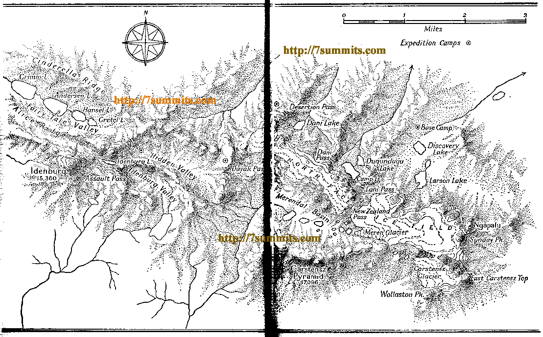
There is a map of the Carstensz area that is significantly out of date in terms of glacial ice extent, but that nicely shows the positions of the peaks. It can be found here.
Weather
Mountain-forecast provides a weather forecast for nearby Carstensz Pyramid (Puncak Jaya). It can be viewed here.Other Activities
 A nice camping spot while waiting for the plane to Igala.
 Snorkeling after the climb.
Here is an enticing picture of Ahe Island.
In the town of Timika, Freeport Mine's company town of Kuala Kencana has a wonderful nature trail through lowland rainforest as well as habitat for a magnificent array of butterflies. Timika had no t-shirts that we could find, although there were about 5 shops that sold masks, carvings and other traditional artifacts.
Parting Image
 Sumantri and Puncak Jaya at Dawn.