Account of Events
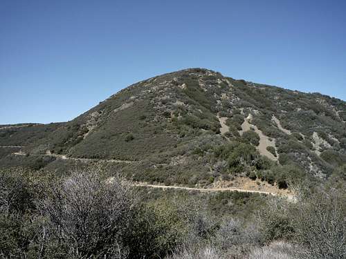
![Holy Jim Trail]() Holy Jim Trail as it traverses the head of the Holy Jim Canyon.
Holy Jim Trail as it traverses the head of the Holy Jim Canyon. The alarm woke me at 5am on a Saturday morning. Sometimes I ask myself why I am doing this. After a hectic week I should relax and regain some energy on the weekend. But for me there is an easy answer. Waking up that early to hike up some mountain on the weekend is my form of relaxation. I may be physically tired but mentally nothing is more invigorating for me. I often cannot sleep at all in anticipation of a beautiful day in the mountains. The plan was to drive to Laguna Hills in Orange County, meet with some other hikers, and climb the highpoints of Orange County, Modjeska Peak and Santiago Peak. Both form the “Saddleback Peak”, what can be seen from many places in Southern California. They lie within the Cleveland National Forest and are part of the Santa Ana Mountains. There are many ways up to these peaks, most on fire roads that crisscross that mountain range. We picked the Holy Jim Trail from Trabuco Canyon and ascend to Modjeska Peak first and bag Santiago Peak on our return route. I arrived at 7 am at the parking lot of the El Toro Mall and welcomed the other 8 hikers of our party. We gathered our stuff into two 4WD vehicles and drove to the trailhead in Trabuco Canyon. It seemed that the last five miles on the rough Trabuco Creek Road took forever. They are currently fixing the road on many places, so there might be some road closures in the future. After about one hour of driving we parked the cars at the trailhead at the entrance of Holy Jim Canyon behind the fire station (1,730’ elevation). We learned that on that day there was the 50 mile Old Goats Endurance Run on the trail and fire roads.
![Modjeska Peak]() Modjeska Peak
Modjeska Peak We started at around 8:30 am going north into Holy Jim Canyon. After about half a mile and passing several private cabins we arrived at the actual Holy Jim Trailhead with a sign and gate. The first 1.5 miles are an easy stroll in the canyon bottom along the creek with plentiful of Poison Oak alongside. We crossed the stream at least six times without any problems. After the turn-off to the Holy Jim Falls the trail now turned west and zigzagged up the western slope of the canyon. On our way we encountered many beautiful wildflowers. After about 3.5 miles and 2,000 feet of elevation gain the trail now turned east and crossed the upper portion of the Holy Jim Canyon. This traverse seemed to have dipped recently probably as the result of a landslide. After another mile we reached the Main Divide Fire Road (~3,950’ elevation) where one of the aid stations for the mountain race was setup. The Lower Holy Jim Trail from our cars to the Main Divide Road was about 4.7 miles with 2,200 feet of elevation gain.
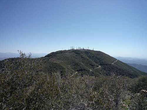
![Santiago Peak]() Santiago Peak
Santiago Peak We took the fire road about half a mile to the east to the turn-off of the Upper Holy Jim Trail (~4,000’ elevation). The trail now significantly steepened and views opened up north and east to the surrounding Santa Ana Mountains, the San Bernardino and San Gabriel Mountains, and San Jacinto Peak in the distance. Beautiful Lake Elsinore was visible to the north as well. After about 0.8 miles and 800 feet of elevation gain we crossed the Main Divide Road again. At that point the road makes a sharp turn to the west towards Santiago Peak. After another mile and 600 feet of elevation gain on the dirt road we reached a small saddle north of Santiago Peak, where the road turns south towards the summit. After a short break we took a use trail from the saddle, which descended about 500 feet in 0.6 miles on the north side of Santiago Peak to the saddle between Santiago and Modjeska Peak. At the saddle the use trail connects again with the fire road, which leads around the southwest slope of Modjeska Peak to the summit. A shorter alternative, which we took, is to take another use trail from the saddle. This partially overgrown trail ascends the south slope of Modjeska Peak and shortcuts to a rough dirt road about 0.5 miles below the summit. We followed the road to the summit at 5,496 feet. To our first peak we now hiked a total of about 9 miles and gained a little bit less than 4,000 feet of elevation. The views from the top were marvelous: the Pacific Ocean with Catalina Island, the snow-capped summits of Mount San Antonio, San Gorgonio, and San Jacinto, and the sprawling area in between. We enjoyed our lunch very much.
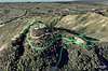
![Santiago and Modjeska Peak - TOPO]() TOPO of our trip
TOPO of our trip About 20 minutes later we were on our way to Santiago Peak. We hiked back to the saddle from where we left the road towards Modjeska Peak. Half a mile on the fire road and we were greeted by angels. Literally, shortly before the towers-capped summit of Santiago Peak was the 36 mile aid post for the Old Goats Race. The young people working there (mostly young women) all worn red costumes with white wings and halos. One even played the harp; really funny in a way but a welcome sight. We chatted a bit and moved up to the true summit where we had another short break. The summit itself is much less picturesque than Modjeska Peak with all the antennas but the views are nonetheless gorgeous. Knowing that we had about 9 more miles to go to get to the cars we kept moving. We had a good pace on our way back and reached the cars less than 3 hours after we left the summit. Tired but having the great feeling of accomplishment we drove the long way out of Trabuco Canyon back to our cars and finished the day with a good burger and some drinks. Overall the hike totaled to about 20 miles with about 5,000 feet of elevation gain. It took us less than 9 hours to complete the trip.
Disclaimer: The track was recorded on a Garmin GPSmap 60CSx with coordinate savings every 30 seconds. Mileage- and elevation readings were calculated after importing the gpx file into National Geographic’s Topo 4.0 software.


Comments
Post a Comment