
|
|
Route |
|---|---|
|
|
45.54630°N / 7.27470°E |
|
|
Hike & Scramble |
|
|
A long day |
|
|
EEA (expert trekkers with gear) |
|
|
Approach
 |
- From France, through the Mont Blanc Tunnel or the Col du Petit Saint Bernard: you can drive on SS.26, following the direction for Aosta and, before arriving in Villeneuve, turn right towards Introd. Alternatively, you can take motorway A5 (at Courmayeur or Morgex) and exit at Aosta Ovest.
- From all other directions: get to the Aosta Ovest exit of motorway A5. Then drive along SS.26 Aosta, direction Courmayeur, and just after Villeneuve turn left towards Introd.
Route Description

Starting point: Eaux Rousses (Valsavarenche) 1666 m
Highest point: unnamed pass at 3245 m (sometimes, but seldom, named "Col Money di Valsavarenche")
End point: Praviou (Valsavarenche) 1836 m
Elevation gain: 1579 m
The difference in elevation and the length of the route, added to the necessity to tackle a steep section with fixed chains at high-altitude (above 3000 m), require good training.
The route is classified EEA (expert trekkers with gear)
Period: middle of July - middle of September. The second half of July may be characterized by residual snowfields in the highest part of the trail and some further difficulties to ford some glacial streams because of their rate of flow.
Note: the starting point (Eaux Rousses) is about 3 Km from the ending point (Praviou). It is therefore advisable to have a second car placed at the end of the route (one can also hitchhike or catch the rare bus).
The route can be followed in both directions, keeping in mind that: ![]()
THE FOLLOWING DESCRIPTION ASSUMES EAUX ROUSSES AS STARTING POINT
Leave the car in the roadside parking, cross the river on a large wooden bridge, then keep the mule-track following the Gran Paradiso National Park signs to Lévionaz and Col Lauson.
Shortly, the path crosses some pastures and follows in the direction of an alluvial cone climbed by some hairpins. One can see, on the opposite side of the valley, the characteristic reddish cliff, whose colour is due to iron salts contained in the water running along the rocky slope. That water gave the name Eaux Rousses to the village.
One can arrive at this point of the route also descending into Vallone di Lévionaz from a panoramic trail starting from Degioz and passing first near Bocconere hut and then, at the Gorges de la Grivola, near the white ancient hunting-emplacement (2573m) built in the second part of the 19th century for Vittorio Emanuele II, the first king of Italy.
![]() At the head of the valley, the path, always good and well marked, crosses the stream on a bridge, passes near the ruins of the Alps of Lévionaz du Milieu (2336 m): then the steepness increases sharply and some hairpins lead to a fork: ignoring the continuation of the trail towards Col Lauson, turn right in the direction of Alps of Lévionaz d'en Haut.
At the head of the valley, the path, always good and well marked, crosses the stream on a bridge, passes near the ruins of the Alps of Lévionaz du Milieu (2336 m): then the steepness increases sharply and some hairpins lead to a fork: ignoring the continuation of the trail towards Col Lauson, turn right in the direction of Alps of Lévionaz d'en Haut.
Because of the considerable altitude (2648 m) and the consequent absence of trees, this old building shows an unusual roof structure entirely made of stones.
(A possible digression leads to another Casa di Caccia (2663 m), at the foot of Punta Leisèr (3155m)
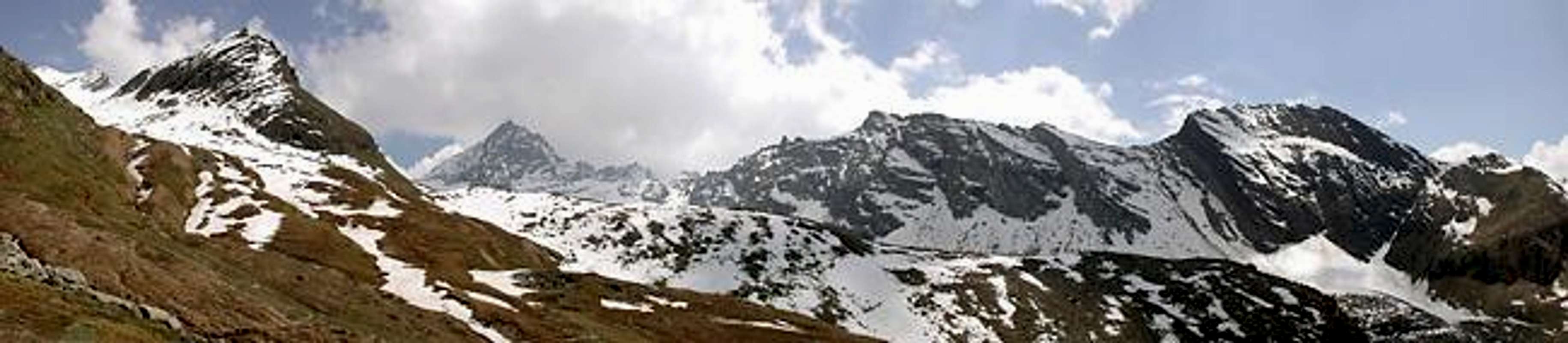
![]() Looking backward one can see a wide sector of the opposite watershed betweeen Valsavarenche and Val di Rhêmes.
Looking backward one can see a wide sector of the opposite watershed betweeen Valsavarenche and Val di Rhêmes.
At this point the scenery changes considerably and a wild high mountain environment, dominated by Herbetet and his glaciers, takes the place of the pastures.![]() Also the path changes and progressively becomes a more and more tiring high mountain route. At its head, Vallone di Levionaz splits into Vallone dell'Inferno (left) and Vallone di Timorion (right).
Also the path changes and progressively becomes a more and more tiring high mountain route. At its head, Vallone di Levionaz splits into Vallone dell'Inferno (left) and Vallone di Timorion (right).
After the ford of a first stream (Vallone dell'Inferno), the trail bypasses a moraine, remnant left by the Timorion Glacier receded since time immemorial, and descends gently towards the bottom of the Vallone di Timorion where, in a flatter area, some other streams coming from the Grand Neyron Glacier must be forded.
Here starts the more tiring part of the route that rises on the steep edge of a long morain, from 2700 m to 3000 m.
![]() A wide detrital area, often snow-covered at the beginning of Summer, leads to the base of the sharp ridge connecting Punta Money to Herbetet.
A wide detrital area, often snow-covered at the beginning of Summer, leads to the base of the sharp ridge connecting Punta Money to Herbetet.
An iron stair and a sequence of chains allow one to overcome easily the rocky steps.
The slope, to negotiate with attention, can be divided in short segments with easy rests.
The narrow unnamed pass opens close on the left of the small Pyiramide du Grand Neyron, not to be confused with the more imposing Tour du Grand Neyron, rising further west in the direction of Punta Money.
The view from the pass towards the glaciers, Becca di Montandaynè, Piccolo and Gran Paradiso is really impressive.
The descent towards vallone di Montandaynè along big boulders is much easier than the ascent; the route firstly goes left, then turns north-west and reaches an old mule-track that descends alongside Punta Money.
Later the track turns south east, crosses pastures and "roches moutonnées", fords some streams and finally goes shortly uphill as far as Costa Savolera, in the vicinity of the Chabod refuge (2750 m).
A very good path connects the Chabod refuge to Praviou, taking back from the glacial environment first to the woods and at the end, after Alpe Lavassey, to the valley bottom (1836 m).
Highest point: unnamed pass at 3245 m (sometimes, but seldom, named "Col Money di Valsavarenche")
End point: Praviou (Valsavarenche) 1836 m
Elevation gain: 1579 m
The difference in elevation and the length of the route, added to the necessity to tackle a steep section with fixed chains at high-altitude (above 3000 m), require good training.
The route is classified EEA (expert trekkers with gear)
Period: middle of July - middle of September. The second half of July may be characterized by residual snowfields in the highest part of the trail and some further difficulties to ford some glacial streams because of their rate of flow.
Note: the starting point (Eaux Rousses) is about 3 Km from the ending point (Praviou). It is therefore advisable to have a second car placed at the end of the route (one can also hitchhike or catch the rare bus).
The route can be followed in both directions, keeping in mind that:
- Direction Praviou - Eaux Rousses: the elevation gain is smaller (1409 m instead of 1579 m), the path is easier as far as the unnamed pass, but the steep technical section has to be downclimbed.
- Direction Eaux Rousses - Praviou: the demanding section of the route is more tiring but it is followed uphill.
The part with chains is, all in all, short and easy, but take into account that it has to be negotiated above the height of 3000m and in tiring conditions.
THE FOLLOWING DESCRIPTION ASSUMES EAUX ROUSSES AS STARTING POINT
Leave the car in the roadside parking, cross the river on a large wooden bridge, then keep the mule-track following the Gran Paradiso National Park signs to Lévionaz and Col Lauson.
Shortly, the path crosses some pastures and follows in the direction of an alluvial cone climbed by some hairpins. One can see, on the opposite side of the valley, the characteristic reddish cliff, whose colour is due to iron salts contained in the water running along the rocky slope. That water gave the name Eaux Rousses to the village.
 |  |  |
The mule-track, always wide and evident, enters the wood and leads in 1h and 30' to the hamlet of Lévionaz d'en Bas 2303 m, including also a tabernacle and a hut of the Gran Paradiso National Park rangers. A picnic table and a small, fresh fountain are set in a very panoramic position.
 |  |  |  |  |  |  |
Beyond the houses, by a short downhill enter the "Vallone (side valley) di Lévionaz", dominated by the Gorges de la Grivola and an old white Casa Reale di Caccia ( royal hunting hut). Along this part of the route, which gently slopes across the valley, it is easy to see many animals: marmots, ibex, and chamois.
 |  |  |  |  |  |
One can arrive at this point of the route also descending into Vallone di Lévionaz from a panoramic trail starting from Degioz and passing first near Bocconere hut and then, at the Gorges de la Grivola, near the white ancient hunting-emplacement (2573m) built in the second part of the 19th century for Vittorio Emanuele II, the first king of Italy.
 |  |
 At the head of the valley, the path, always good and well marked, crosses the stream on a bridge, passes near the ruins of the Alps of Lévionaz du Milieu (2336 m): then the steepness increases sharply and some hairpins lead to a fork: ignoring the continuation of the trail towards Col Lauson, turn right in the direction of Alps of Lévionaz d'en Haut.
Because of the considerable altitude (2648 m) and the consequent absence of trees, this old building shows an unusual roof structure entirely made of stones.
(A possible digression leads to another Casa di Caccia (2663 m), at the foot of Punta Leisèr (3155m)
 |  |  |  |
 Looking backward one can see a wide sector of the opposite watershed betweeen Valsavarenche and Val di Rhêmes.
At this point the scenery changes considerably and a wild high mountain environment, dominated by Herbetet and his glaciers, takes the place of the pastures.
 Also the path changes and progressively becomes a more and more tiring high mountain route. At its head, Vallone di Levionaz splits into Vallone dell'Inferno (left) and Vallone di Timorion (right).
After the ford of a first stream (Vallone dell'Inferno), the trail bypasses a moraine, remnant left by the Timorion Glacier receded since time immemorial, and descends gently towards the bottom of the Vallone di Timorion where, in a flatter area, some other streams coming from the Grand Neyron Glacier must be forded.
Here starts the more tiring part of the route that rises on the steep edge of a long morain, from 2700 m to 3000 m.
 A wide detrital area, often snow-covered at the beginning of Summer, leads to the base of the sharp ridge connecting Punta Money to Herbetet.
An iron stair and a sequence of chains allow one to overcome easily the rocky steps.
The slope, to negotiate with attention, can be divided in short segments with easy rests.
The narrow unnamed pass opens close on the left of the small Pyiramide du Grand Neyron, not to be confused with the more imposing Tour du Grand Neyron, rising further west in the direction of Punta Money.
The view from the pass towards the glaciers, Becca di Montandaynè, Piccolo and Gran Paradiso is really impressive.
 |  |
The descent towards vallone di Montandaynè along big boulders is much easier than the ascent; the route firstly goes left, then turns north-west and reaches an old mule-track that descends alongside Punta Money.
Later the track turns south east, crosses pastures and "roches moutonnées", fords some streams and finally goes shortly uphill as far as Costa Savolera, in the vicinity of the Chabod refuge (2750 m).
 |  |  |  |  |  |
A very good path connects the Chabod refuge to Praviou, taking back from the glacial environment first to the woods and at the end, after Alpe Lavassey, to the valley bottom (1836 m).
| Eaux Rousses (start of the route) | 360262 E | 5047656 N |
| Lévionaz d'en Bas | 361991 E | 5048953 N |
| Lèvionaz d'en Haut | 363628 E | 5048064 N |
| Unnamed pass | 364025 E | 5045600 N |
| Chabod refuge | 362594 E | 5044677 N |
| Praviou (end of the route) | 360524 E | 5045207 N |