Brad's Outdoor Adventures
Humboldt Peak, 14,064 feet
Class 2 bushwhack with snow
Distance (round-trip): abt. 8 miles
Elevation Gain: abt. 5,000 feet
Introduction: Having never hiked in the Sangre de Cristo Mountains, I had been looking forward to seeing the area. Humboldt Peak seemed to me an obvious introduction peak, providing an easy hike and awesome views of some of Colorado's most impressive mountains. I drove my jeep cherokee only partway up the rough-as-promised 4WD South Colony Road, to about the San Isabel National Forest boundary, where I camped out for the night.
Cold and restless, I woke up at 0430 and could not get back to sleep. So, I got ready to hike and by 0535 I was walking uphill on the rough dirt road. The moon was bright, so I didn't bother to use my flashlight.
![]()
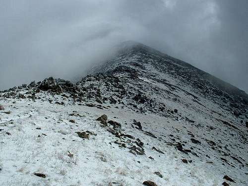
East Ridge above timberline
After about half a mile, I came to the spot where the Rainbow Trail crosses the road. I had decided after some research that I would hike Humboldt's East Ridge instead of the standard West Ridge Route, so I turned right (north) onto Rainbow Trail. The easy-walking trail crossed a bridge at the creek and continued around the ridge. I kept my eyes open for a possible trail leading up the hill, but could find none. Finally, about three quarters of a mile after turning onto Rainbow Trail, I came to an old dirt road. I turned left onto this road and followed it steeply uphill for several hundred yards, until eventually it faded into a trail.
I continued steeply uphill, bushwhacking my way through the timber, assisted by a number of well-defined game trails. Once I reached flatter ground at the top of the ridge, I turned right (west) and continued gaining elevation.
I came to timberline suddenly at 11,500 feet. The sky was mostly clear, but the valley to my south was totally shrouded by snow-filled clouds. I could not see the mighty Crestones, and as I steadily marched uphill, the clouds of snow began to engulf me as well.
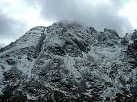
![]()
Looking back up Humboldt Peak's West Ridge
From timberline, the path to take was steep but obvious, all the way up to the first false summit, at about 13,000 feet. This is simply the end of a long ridge leading uphill to Humboldt Peak's summit. Unfortunately, by the time I got there I couldn't see farther than perhaps a hundred yards.
An exact repeat of last week's hike on Huron, I could see nothing but the terrain immediately in front of me as I continued upward. The snow was not very heavy, but it was joined by a thick fog and fierce winds. As I was walking westward, the wind was howling against me the whole way.
Terrain-wise, however, this was actually one of the easiest sections of walking. The long and narrow ridge-line was almost level and easy to walk for a good distance. Eventually it did get a little steeper, with mounds of talus and steep dropoffs to the north edge. Also the snow was deeper near the top, but there was no more than a few inches and it really didn't impede my progress.
At 0923 I stepped onto the summit of Humboldt Peak, at 14,064 feet above sea level. The wind was blowing very hard, so I sat within the circular stone-walled shelter to shield myself as best I could. I had no view, just as last week, but I sat there anyway enjoying the solitude of the 37th highest point in Colorado. I only enjoyed it for about 20 minutes, though, as I was getting chilly and really had no reason to stick around.
I exited via the standard West Ridge Route, which is well marked with cairns and easy to follow. However, this was the toughest part of my hike, as a fresh layer of fine, slippery snow coated all the talus. It was almost like sliding down a bumpy hill made of ice.
Two nice things happened at this time: The snow stopped falling, and the thick fog began to let up at places. However, as I made it down to the saddle, I waited and waited for the fog to clear completely, but it would not. It did roll out of the valley, so I was able to see the South Colony Lakes below and the beginnings of the mighty Crestones behind them, but I could only see maybe a third of the way up the slopes.
So, after about two hours of standing around and unsuccessfully trying to coax the fog into disappearing, I began down the switchbacks to the South Colony Lakes. These are beautiful lakes in an incredible setting, and I stopped often to take pictures as I descended the trail toward the dirt road.
Once on the dirt road again, I continued downhill to the 4WD parking lot, where a jeep and a truck were parked. I had seen some fresh footprints in the snow, but I did not see another human all day. What I did see from here, finally, was a clear view of Crestone Needle. The fog had lifted just for a moment, and I was able to snap some pictures of an incredible mountain. I plan to go back to this area next summer to tackle the Crestones.
From here I had a little more than three miles left to make it back to my jeep. It was all easy downhill walking along the rough South Colony Road. I am sure my jeep could handle all the tough spots on that road, but I don't think I would be able to handle my jeep well enough to avoid damaging it. There are some pretty deep gouges and big and sharp rocks along the way.
As I rounded one of the turns, two deer, a doe and a fawn, ran just a short ways into the timber. I sneaked into the woods and was able to snap a picture of the doe before the deer got too nervous and bounded off into the forest.
I arrived back at my jeep at 1525. The drive out was actually easier than the drive in had been the night before.
Conclusion: I very much enjoyed my first visit to the Sangre de Cristos, and look forward to returning as soon as I can. The weather was unfortunate, but the forecast was questionable and I was prepared for that. Bushwhacking my way up Humboldt Peak's East Ridge was a fun experience, but I can't wait to try some of the more difficult challenges the range has to offer. I'll be back!
Comments
No comments posted yet.