Acclimatization Hike- Iztaccihuatl
Ever since I climbed my first fourteener back in '84 (I think?), Longs Peak, I had been dreaming of climbing bigger mountains. I didn't get the chance until I finished my education at the tender age of 33! Last August I climbed Mount Rainier with RMI, and afterwards felt I would be up to the challenge of bigger mountains (to my family's dismay!).
I had been planning a trip to Mexico since August for a chance to climb something higher than 14k feet that wouldn't require much (or any technical diffuculty) other than cramponing/self arrest skills and good shape. I flew into Puebla on a Friday evening to avoid Mexico City and its traffic after working nights the past week. Puebla also seemed to make sense as it is nearly in between Orizaba and Iztaccihuatl. I rented a small sedan and took out as much supplemental insurance as possible which is important, as American insurance is not necessarily recognized there. I also wanted more freedom of mobility in case my plans changed, and I only had a week to spare. I spent my first evening at the Hotel Colonial near the central zocalo in Puebla which is reasonable ~$54 US and a nice place to stay- they have their own website
www.colonial.com.mx and the front desk staff speaks good English.
After a much needed rest and tasty breakfast of eggs with mole at the hotel resataurant I hit the road to Amecameca near Izta.
![Iztaccihuatl from outskirts of Amecameca]() Iztaccihuatl from outskirts of Amecameca
Iztaccihuatl from outskirts of AmecamecaAmecameca makes sense if you are going to Izta for several reasons: 1) You get a permit for entering the Izta/Popo park ($1 US per day) which you show the military guards at a checkpoint before you get to Paso de Cortes. The office is next to the central church at the town square to the right of the church as you face Izta, it's on the second floor. 2) There are small grocery stores where you can find purified water (I used 10 liter plastic bottles which cost ~$1.50 US) and food- I bought some pre-made ham and cheese sandwiches and tortillas (used with Nutella) for almost nothing. 3) I bought white gas (gasolina blanca) at a Comex store which sells paint for my stove. The store can be found ~1-2 blocks from the central square. That afternoon I drove to La Joya, set up my camp and took a brief hike to ~14k feet and returned for dinner and a nap.
![La Joya]() Parking area, La Joya
Parking area, La Joya
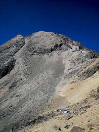
That evening I awoke early to a bull lowing and tramping around my tent about 12:30 so I thought I might as well get up before he takes out my guy lines, fix breakfast and break camp. I guzzled as much water as I could stand the previous evening and during breakfast, and was on my way. The sky was spectacular- I could see shooting stars everywhere, and lights below from the D.F. I had some route-finding difficulties and got-off track a few times, but found the trail at the other side of the Portillo where other hikers were making their way to the Rodillas (knees). I didn't have any altitude trouble- I started taking Diamox 2-3 days before climbing (125mg twice daily), but the scree to the knees was a little painful, especially above the hut just above 15k feet past the Portillo.
![Route to the knees]() Steep scree/talus slope below the knees.
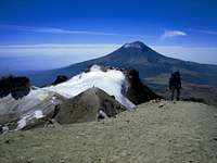
Steep scree/talus slope below the knees. Once I made it to the knees, the trail was much more enjoyable with good trails and great views of Popo which was occasionally smoldering, and even views to Nevado de Toluca and Orizaba in the distance. There were many Mexican climbers who were climbing together via the Ayoloco glacier on the 70th anniversary of their alpine club- some of them even set camps near 17k feet! There was really no snow on the mountain with the exception of the receding Ayoloco, belly and summit (pecho) glaciers. Crampons weren't necessary and crevasses were pretty small, so I used my usual Colorado 14er boots- Asolo Fugitives which worked well. I gained and lost altitude as I passed over a few false summits but I didn't mind as the trail and views were outstanding.
![To the top!]() Ridge trail from the knees to el pecho.
Ridge trail from the knees to el pecho.When I reached el pecho, I had to make a tour of the three small summits which took ~45 leisurely minutes because the old high-point (the breast snowfield) has receded below these points and no one is really sure which of these is the highest, so I did them in a clockwise fashion.
![?True summit of Izta]() Izta summit shot
Izta summit shotFrom the tops I could see my next objective- Orizaba.
I made my way down from the top and arrived at La Joya a little after 4pm and spent the night in a roadside hotel somewhere between Amecameca and Chalco. I spent the next day and a half touring Teotihuacan which was special for me since I had studied it in college. Next I headed for Tlachichuca.
El Pico
Driving into Tlachichuca was special for me- I finally saw in front of me the mountain which was my goal for the last year looming in front of me. And loomed it did- this was the biggest mountain I had ever seen.
![Orizaba from the entrance of Tlachichuca]() First look of Orizaba entering Tlachichuca
First look of Orizaba entering TlachichucaI found my way to the compound of Senor Canchola
cancholashouse@yahoo.com.mx and made myself at home. There was a group of climbers, led by Roberto Flores AKA "Oso" who returned from a sucessful climb of Orizaba. Among them was a 14 year-old! Mrs Canchola cooked me a big meal including milk from the family cow, and I organized my pack for my trip to Piedra Grande the next day.
The next morning Joaquin (Mr Canchola) drove me to the hut- he normally charges $50 US per person, but I paid $100 US since I was the only client that day (he also returned to Piedra Grande early the next day ~12:30 which was really appreciated since I was back at the hut by noon). The trip took about two hours, was very, very dusty and
not suitable for a rental vehicle in my opinion. Piedra Grande was very windy and lonely as I was the only one there for awhile. There was gear from an Italian climber who returned shortly after a failed summit bid- he didn't like the ice ~300 meters below the summit. The hut was also lonely for another reason too- there was a memorial plaque for a young climber, set by his family and friends, who had died a few years ago from AMS. Two US climbers had also joined me in the hut some time later after they decided to come down from a high camp after one of them developed symptoms of AMS. The hut was dirty, but better than sleeping outside in the wind, so I settled down for a not-so-restful nap after eating dinner and pounding as much water as possible. The mice really do come out at night for a snack as you can see here:
![Keeper of the hut]() Keepers of the hut!
Keepers of the hut!
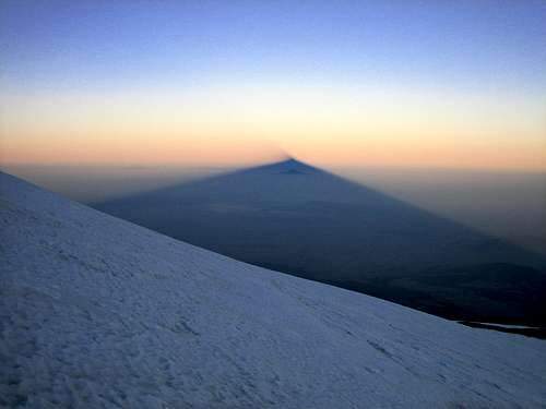
When I got up around 1:30 I was greeted by a windless, clear night, about 32F- just about perfect. At 2:30 I started up the aqueduct toward the labyrinth. Route-finding was actually not a problem. I followed a worn trail, cairns and spray-painted symbols (which resemble "parking verbot" signs if you have traveled in German-speaking countries, which caused me some anxiety at first because I thought they indicated false trails!). I passed a high camp before exiting the labyrinth, passed to the right of a prominent cliff band and exited the labyrinth near the site for the highest potential dry camp which seemed like it might not be the best choice for a restful night (mine seemed to probably not be the best choice either). After a few minutes more I reached the tongue of the Jamapa Glacier and put on my crampons- a good feeling to me. I looked up and could see the rocks a little below the summit. At the Cancholas' I had talked with Oso who told me the last 300 meters or so were quite icy so he recommended the Ruta Espinosa and had placed wands along the route earlier this season. I more-or-less followed a line between the usual Jamapa Route and Ruta Espinosa (closer to the Ruta Espinosa). The hiking was straight forward. Rest-stepping and occasionally pressure-breathing, I thought I wouldn't stop until I reached the summit- until I reached about 17k feet. I didn't get really short of breath, but after 8-10 steps I felt like I needed to stop for a few seconds before continuing. I set the next wand ahead as a goal, and made my way up. Shortly after sunrise the shadow of Orizaba stretched across the horizon just like other mountain shadows I had seen pictures of on SP- really a great feeling to finally see first-hand!
![Obligatory shot of Orizaba s shadow]() Orizaba's shadow
Orizaba's shadowThe last 300 meters did indeed have some icy spots in veins as the slope steepened a bit to around 40 degrees, but this was not problematic. Just before 9:00 I reached the summit rim and received a blast of sunshine (just like Tim Roth when he opened Marcellus Wallace's suitcase in Pulp Fiction!) as I gazed into the crater's maw and saw the Aguja de Hielo (ice needle) in the distance- which was great because I realized I didn't have far to go.
![Orizaba s crater with Aguja de Hielo]() View from the crater rim
View from the crater rimAfter 5 more minutes I passed over a small false summit and reached the summit with its collection of crosses, plaque, metallic junk and prayer-flags- also very familiar from SP Orizaba summit pics! I reached the top at 9:00 and spent about 30 minutes, alone on the top- probably the highest person in North America at the time. It was a great feeling. I could see Izta and Popo off in the distance. The weather was great- 32F and no wind! Unfortunately my view to the east was obscured by clouds- just like my view to the Puget Sound when I climbed Rainier. Oh well- I guess I've always preferred the mountains to the beach anyway!
![Orizaba s summit]() Top of Mexico
Top of Mexico
Some random and (maybe) helpful thoughts:
I found R.J. Secor's book on the Mexican Volcanoes to be very useful as well as SP and SP users who were very helpful to me when planning my trip. In my opinion physical fitness, acclimatization, hydration, good information/planning and weather (read here luck) and Diamox helped me to reach my goals. Although these mountains do not pose many (if any) technical difficulties you may be putting yourself at risk if conditions are not favorable and/or if you don't appropriately plan your trip which includes physical preparation as well. On the other hand, if you do these things and use good judgement you will have a great time on these mounatains whether or not you reach the top. The many Mexicans I met were very pleasant, friendly and helpful despite my poor Spanish skills- this I found to be as enjoyable as the mountains themselves.


Comments
Post a Comment