My Dad and I had always wanted to climb Longs Peak but we felt that there was no way that we would attempt this mountain without a guide from the YMCA, or something like that (what changed; I don’t know). Earlier this year I hiked Pikes Peak (my backyard), and Mount Belford (in a monsoon), and after my fourth fourteener ascent we decided that Longs Peak was worth a try. Apprehensive of what we had heard about the exposure on the keyhole route we decided to try to find an alternate route (my first mistake). After throwing around the three non-technical routes on Longs, we decided to try Keplinger’s Couloir. This was said to be an easy route up Longs south side, but requiring a backpack trip even though it’s only one mile longer then the keyhole route. Not knowing what we were in for, my Dad and I (and two friends) left for Wild Basin.
July 28th 2006:
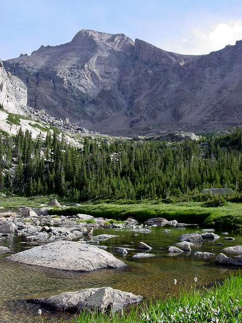
My Dad and I left Colorado Springs at around 6AM and arrived in Estes Park around 8:30. We ate Breakfast at Molly B’s (this is highly recommended because if you’re backpacking a good meal is a necessity because you WILL NOT eat well while camping). After breakfast, we left the Sandbeach lake trailhead around 9:30 or so. We had reserved a camp site at Sandbeach. We were going to set up camp and try to reach the base of the couloir (so we knew what we were in for), before Christin and her Dad arrived.
![Sandbeach Lake]()
The walk to Sandbeach Lake is very nice on a maintained trail. We arrived at the Lake around 12:00 and set up camp. We ate lunch and decided to try and find a way to the base of the couloir. We hiked northwest from the lake at a heading of 305 (Which one report said to do. This made more sense to us then heading north for a while and then northwest at 340 which is what Roach says in his 14ers guide book.), soon we wound up in a very large boulder field. Slowly and carefully we climbed over and around the boulders, thinking that this section couldn’t last very long because no report had mentioned it.
Over an hour later we reached what we thought was the end of the boulders, only to find a cliff that lead to Hunters Creek a couple of hundred feet below. Frustrated, tired, and morally defeated we sat on a rock and realized that we had traveled .2 miles in an hour and a half. Coming to the realization that we probably would not even get to couloir the next day, we made our way back to camp.
It was getting late when we accidentally stumbled across a climbers trail (north side of the lake), while on our way to get water. We followed it for a while and decided that in the morning we would use it.
July 29th 2006:
I got up at 5:30, which didn’t come soon enough. Camp sleep is like no sleep. I ate a cliff bar and walked down to the lake to snap some pictures while the rest of my party got ready. At around 6:15 we left Sandbeach and started up what we thought was a trail to the Longs, Pagoda, and Meeker basin. What we didn’t know was that a mile back down the Sandbeach trail was the correct turn off. No one mentioned this in any report. The way I found out about it was by reading a guide book to Rocky Mountain National Park (The Complete Guide to Rocky Mountain National Park). I have personally not taken this trail, but it can’t be worse then what we tried. If you can’t find this trail (near Hunter’s Creek) you can always do what we did. The trail we took was very steep and slippery at some points. After about 15 to 30 minutes of hiking we came out of the trees on the north ridge of Mount Orton.
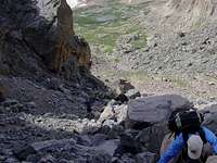
For the first time we were able to see Kelplinger’s Couloir. It is the largest and longest couloir and is easily spotted. Thankful to be able to see where we were going and be above the rocky mess in the ‘canyon’ below us, we stayed low on the ridge as long as we could until we reached a bowl. At this point we had two choices; climb higher on the ridge to
![Wild Basin]()
avoid the bowl and descend before we reached Chiefs Head and Pagoda on the other side, or descend into the basin. Worried about the time, it was already 8:00, we decided to descend to the basin. This soon proved to be more challenging than expected. The grassy slope soon became very, very steep. Slowly we descended until our progress was stopped by some pesky cliff bands. Not wanting to climb back up the steep slope we started down-climbing the obstacle. I don’t remember how long we were stuck out there, but it felt like forever. Some of my party above me knocked down some loose rock and I watched it crash in to the basin. This was the first out of what became a normal occurrence on this trip.
![Mount Orton]()
Finally all four members of my party reached the basin (one of the most pristine area in RMNP). Thankful to be able to walk on stable ground again we tried to find the unnamed lake, mentioned in all route descriptions. We could hear the running water from Hunters Creek, so we followed our ears. After a few minutes of walking we found ourselves boulder hoping (again!!!). This time the boulders weren’t nearly as bad. A pond appeared abruptly in what seemed like the middle of the boulders. We thought that this was the unnamed lake, but guess what…!?! We were wrong again (see a theme). The unnamed lake is an actual lake and was still further ahead.
When we reached the real lake, we decided to skirt around it on the left to avoid the messy marsh created by the rivers on the right (now would be a good time to mention that I would recommend Gortex boots). After sloshing around for a while we climbed though some trees into the high basin at the foot of Long’s. Avoid the temptation to cross the streams too early. I tried this and crossed the river about EIGHT times, almost ending up waist deep water every time. Meanwhile Christin’s dad stayed left of the stream and ended up a dry, somewhat happy, man because he only had to cross the river once!
![Longs South Side]()
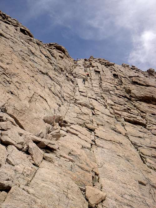
If you can avoid the river all you have to do is make your way to the foot of the couloir. Unfortunately that is not as easy as it sounds, especially if you don’t take the time to look around and find the path of least resistance. Finally, after a grueling three and half hours of bushwhacking, we made it to the foot of the couloir. Keplinger’s Couloir is 1600 feet of loose, wet, rock that plops you just below the Notch. Named after the man who scouted out the route for John Wesley Powell, (who made the first recorded ascent of Longs in 1865, via Keplinger’s Couloir) this route is difficult and dangerous in the summer.
We stopped to rest, trying to only look behind us to see how far we had come. Unfortunately Longs Peak loomed behind us. Making all of us wonder how and why were going to do this. Pulling ourselves together we finally started climbing the friendly car-sized-boulders. At this point I threw all doubt away thinking, “this is easy, we got this in the bag”.
How quickly things can change. Before we knew it we were 400ft. into the couloir, the rock had changed to scree, the angle of ascent went through the roof, and we were stuck on a mountain. To scarred to go up, and to smart to go down.
Climbing up felt like the only option. We would stop every several hundred feet or so to wait for the group to catch up. As we waited I tried to save face and keep a positive attitude, but the whole time I was thinking “How are we going to get off this dumb mountain? I’m not going down this rock/scree/dirt mess they call a couloir! And I still know nothing about the mystery 300ft. after Keplinger’s and before the homestretch!”
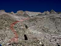
Up until about 13000ft. the couloir was dangerous, but straight forward. At this point though, we were faced with a choice of left or right, because a wall of rock splits the couloir down the middle. There are no cairns here for two reasons I suppose. One, no one in there right mind would climb this during the summer, and two, it’s so steep the cairns would just fall down the couloir, so you’re left to fend for yourself. I was told keep the palisades (the spectacular cliffs on Long’s south side) on the right. I figured I would heed this advice and keep the cliffs as far to the right as I could, so Christin and I went left. Our dads however, went to the right. I honestly don’t know which choice is better.
Going left, Christin and I soon ran into ridiculously loose rock. This wonderful climbing was ruined only by a stream flowing down the rocks. As we climbed this section the exposure became an increasing factor. At one point I remember testing a hand-hold and a foot-hold, then thinking that they were safe. Suddenly my foot-hold gave way and I was hanging by my hands for an instant. I started swimming up the mountain in panic, kicking and pulling whatever was in my way sending a spray of rock down the couloir. This turned out to be ok because our dads were already on the other side and there was no one else below us. After a panicked few minutes of climbing we reached the end of the rock rib that splits the couloir.
While I was waiting there I thought about the rocks I kicked down. I don’t think that any one could avoid this (none of us did). It’s just a danger that this route, during the summer, entails. When my dad reached where we were he explained that the right side was less loose, but required a move where you had to wedge your arm in-between two rocks and pull yourself over the exposed ledge. His story was later affirmed by Christin’s dad.
![Steep & Loose]()
We were only a hundred feet or so from the end of the couloir, but we still couldn’t see how we were suppose to transition to the homestretch. At this moment we heard a helicopter overhead and started pray he was coming to save us, not thinking about what was actually happening. The last hundred feet of climbing were relatively easy. I couldn’t tell exactly where we were supposed to get off, none of it looked easy. About 200ft. from the notch I decided to exit the couloir. This move offered little in the way of handholds and you just hoped you later enough had momentum to scramble up the rock.
From there you could see the 300ft. of exposed ledges that led to the homestretch. The ledges were large stable rocks (thank goodness) that just had a small amount of loose rock covering the top. This section passed quickly and I soon saw a person on the keyhole route (this was a big deal, let me tell you). The ‘bullseyes’ were a God send, and the friendliest things I have ever seen. As I waited for the rest of my group I talked to a few people about the keyhole route and decided that would defiantly be the safest way to descend.
It was late (1pm) and I was eager to get to the summit, but I was in heaven on the stable rock, I didn’t care much about the steepness or smoothness of rocks on the homestretch. I had also heard a lot about the exposure on this part of the mountain and felt, at that moment, that it was over-rated. This section took longer then I thought it would and was glad when the flat summit appeared (no false summit!!!). This was by no means a walk up and you can’t just skip to the summit (like someone thought). The best advice is to stay in the cracks.
On top we decided to descend the keyhole route. By the time we started down in was almost 2 (praise God we had good weather). I was a little worried about down climbing the homestretch, because of the smooth slabs. Quickly I learned the rule of down climbing difficult stretches, the butt scoot and bar dip method, just swallow your pride and get on your butt. After the homestretch I saw the narrows for the first time.
It looked bad, but once on it, it was like walking along a narrow sidewalk and the exposure wasn’t a factor.
Once in the trough we learned of the accidents that had happened an hour and a half earlier. Apparently one man fell 70 ft. while down climbing the trough. Then another man went to help him and fell as well.
The first man was air lifted out before we got there (the helicopter we heard earlier) and now a rescue team was working on getting the second victim.
The view from the top of the trough was amazing. We could see Glacier Basin, the Spearhead, and many other landmarks, including Black Lake. Early in the year Christin and I had hiked around RMNP and knew that there was a trail from Black Lake to the Glacier Basin Trailhead. It looked pretty close and we also knew that there was a shuttle from the trailhead to other areas of the park, and since our cars were at Wild Basin we figured that we would just climb down the trough all the way and catch the shuttle out (another mistake).
At this point we had already gone through our 7 Nalgene bottles and were becoming very de-hydrated. Luckily we brought along a water purifier and we found a steam trickling from a snow bank halfway down the trough. After filling up the water bottles and ourselves, we took off down the rest of the couloir.
The second rescue was still underway, a rescue party of about 12, which was now above us, started moving the victim towards the keyhole. They were trying to carry the litter across the narrow section and despite their best efforts, they started knocking huge boulders and other rocks down on top of us. Christin’s dad got brushed on the leg by a rock and several others crashed close by over the next few minutes, but thankfully none of us got plunked. We soon saw another helicopter fly over the keyboard of the winds and land somewhere on the other side of the keyhole.
The rest of the trip down the trough was uneventful, but didn’t pass quickly enough. What we thought was a relatively quick way down, ended up being much longer than we thought. By this point my arms and legs were sick and tired of crab-walking down the mountain and the rock was a lot different at the bottom of the trough then at the top. Smooth slabs from the water erosion replaced the nice, fairly large boulders at the top. We finally reach the bottom of the trough, but had one more obstacle to overcome…a cliff. I just sat on a rock and wanted to give up, “Fly me of the mountain I don’t care anymore!” It was 5:30 and we were still at least two hours away from the trailhead. We angled along the edge of the trough until we found a relatively safe way down. Where we descended was steep and grassy, but manageable. Afterwards I finally felt like I could walk again, and after a few minutes of wandering around in a marsh at the base of Longs, we found the cairns that led to Black Lake.
![Descent from the Trough]()
Around 8pm or so we finally arrived at the Glacier Basin Trailhead, only to find out that the shuttle had stopped running for the night. Eventually we found two nice people that offered to take us to the YMCA, where the rest of Christin’s family was staying. I don’t know what we would have done if it wasn’t for the generosity of those people.
My dad and I rented a room for the night at the YMCA and got up the next morning to hike back up to Sandbeach Lake and pack out our stuff along with Christin and her dads stuff (Christin had become sick from being so de-hydrated and couldn’t go with us). On the way back from Sandbeach, it started raining on us, the perfect way to end the perfect hike.
With all the bad things I have said about this adventure, I wouldn’t have changed a thing, but I definitely wouldn’t do it again. This route could be a great winter route, when the snow covers the loose rock and other obstacles, but I DON’T RECOMMEND CLIMBING THIS IN THE SUMMER!!!
Afterword (Please Read)
Several years later I look back on this adventure and I praise the Lord that things turned out the way they did. One miss step or small uncontrollable event and things could have ended very differently. We were inexperienced and not ready or worthy to be on this route. After hearing about terrible tragedies, like what happened on Humbolt Peak in May of 2007, I can see we made wrong decisions, just like many less fortunate than us.
When I initially wrote this story, I wanted to give beta to those that were thinking about following in our footsteps and I believe that it still accomplishes that goal (and this route may not be as dangerous to an experienced climber). But now I see this report as a great lesson about decision making in the mountains. Read this account, learn from our mistakes, understand what we did wrong so that you (experienced or inexperienced) don’t make similar miscalculated decisions. Here are four (not all) mistakes we made.
First we committed a cardinal sin of mountaineering; we started climbing the actual mountain WAY too late. We may have started early enough if we could have gone straight to the base of the mountain (although I would still recommend starting A LOT earlier…you never know what is going to happen), however we didn’t know where we were going! By the time we reached the base of Keplingers we should have turned around. Second, WEAR A BRAIN BUCKET!!!! The little plastic dome can save your life (that’s a helmet if you don’t understand)! Third, when you pick a route, know the beta! Don’t just fly by the seat of your pants, unless you want to climb “old school”, then make sure you are prepared for the situations and you understand what you are getting into. Fourth (and this is one I have made up, I haven’t heard anyone else say this), either go down the same route you came up or go down the route you originally planned. Lots of people get themselves in trouble because they do exactly what we did, “oh this couloir/face/gully/whatever looks nice, short, and easy. Let’s take it!” WRONG!!! You never know what cliff, loose boulders, or other obstacle is waiting for you just out of sight.
This was an epic that was created by bad decisions and an epic we survived in spite of those bad decisions. I have encountered other epics in the mountains since then, but
good decisions make them fond memories and great stories to tell. I am in no way an experience climber, there are many with knowledge far superior to mine, but I enjoy spending time in the mountains and experience comes with time. Just remember these words by Ed Viesturs “
[the] summit is optional, but getting down is mandatory!"


Comments
Post a Comment