Part two: Lagginhorn and some relaxing Mont Blanc research
What had happened before ...
The most important telephone number in my mobile phone memory during my mountaineering experiences is the service hotline of Swiss meteophone.
It’s not a cheap service and the client will pay some Swiss Francs, but you are connected to a meteorologist, can ask personal questions and will get a detailed proposal even for a single mountain area. That is much better than those recordings other hotlines offer.
I called meteophone on Sunday, 02.09.07 before noon after we returned to Mischabel hut from our Nadelhorn ascent. What they would tell me was relevant for my plans the next days, so I was full of tension. The weather forecast was good and stable weather, continuing with strong winds in higher altitude but only for about 24 hours until Monday about noon.
In the afternoon of Monday an arctic polar front should hit the whole Alps coming from north leading to heavy snowfall down to 1500 meters altitude. Winds should reach 160 km/h in higher altitude from Tuesday on and even it was supposed to clear up on Wednesday again it will definitely stay very windy and really cold.
That proposal buried my plan for soloing Zinalrothorn, because I’d need at least two days of stable weather. With fresh snowfall a degree 3-4 rock climb over 4000 meters wouldn’t be a relaxing experience for a solo alpinist.
I focussed what I could see clearly on the other side of the valley and what I negotiated in my many visits to Saas Fee so far: on the other side of the valley Lagginhorn is located as the second highest mountain of the Wießmies group right in the middle between Weißmies and Fletschhorn.
The normal route is an easy rock climb with a maximum degree of 2+ with some 45 degree ice fields at the last 200 meters underneath the summit.
From Weißmies hut the altitude distance to Lagginhorn summit is something over 1300 meters.
Since the weather developed really well on that Sunday I couldn’t believe this should turn to opposite the next day. I was thinking: “why can’t the bad weather wait for one more day? I would like to enjoy the sun, make my way down to Saas Fee, eat some Pizza and drink a beer and think about new plans the next day…”, but the end of the good weather period was terminated and there was no time to lose.
We checked out and the old hut keeper seamed to change his character to the end of our stay. After I paid he asked, if everything was ok and I really didn’t expect such a question from “Mr. Unfriendly”. I didn’t answer anything and just smiled at him because I didn’t want to adopt his non polite habits.
Sebastian, Katrin and me started our decent from the hut and it was not as nice as going up. In the beginning I gave myself the motivation from doing it fast, so I jumped from rock to rock and tried to move myself into a rhythm, but after the first 400 meters of steep climbing down over rocks I got tired and searched for my IPOD. We reached the Hannig station after 2 hours from Mischabel hut completing more than 2000 meters of altitude going down that day from the summit of Nadelhorn.
Sebastian had the idea of going down the last 450 meters of altitude using Trottinette bikes from the gondola station. Those bikes are rent by the gondola operator as a fun thing for tourists.
We rent a bike each and the operator was so kind to send our backpacks down inside the gondola, so we could ride without them.
I haven’t been riding a Trottinette before, but after my first experience I can tell everybody, that I prefer a mountain bike. A mountain bike can be a “pain in the ass”, if you know what I mean. Those Trottinettes have no seat, and you have to stand in an angle on them. That prevents a “pain in the ass” but leads to “pain in the back”, because the back is not straight. I can tell everyone, that I prefer a “pain in the ass” compared to a “pain in the back”, but tastes are different …
Back at our cars our ways separated, because Sebastian and Katrin had to drive back to Germany, while I just drove some kilometers changing parking position of my car from Saas Fee to Saas Grund.
I left almost all security equipment in my car - no ice screws, no express chains - and only packed my harness and some carabines into my backpack. When soloing I always wear a harness, to be able to assist someone else that might need help in an emergency situation.
At the counter of the gondola that covers the distance to Kreuzboden I met a German couple, that was on the same schedule.
They had been doing the Nadelhorn also this day and after I told them about the weather forecast in front of Mischabel hut they developed the same idea I had: make it up to the other side of the valley and rush the Lagginhorn in the remaining good weather hours of the next day.
We took the gondola together and had an easy hiking ascent from Kreuzboden to Weißmies hut needed less than an hour for the 350 meters of altitude.
I enjoyed arriving at Weißmies hut. The couple that takes care of the hut is really friendly and kind, they cook delicious and around the hut there are many places to sit or couch yourself down and enjoy the panorama of the Mischabel range. It was a warm afternoon and the sun was shining strong.
After a great dinner course I went to bed early and woke up early the next day again. This night was a lot better than the one at Mischabel hut, because the blankets at Weißmies hut are of good quality and they don’t safe the money for heating at Weißmies hut.
![The poor remainings ...]()
I left the hut about 5:00 on Monday, 03.09.07 and could see from the headlights in the dark, that there was already one party ahead of me. The route to Lagginhorn first follows the regular path to Hohsaas hut, but at a certain corner you have to leave that path to the left to make your way up to Lagginhorn. Since I studied my print of the Swiss Top 25 map the evening before, I had the feeling I’ve followed the path already too long, but those two headlights in front of me didn’t turn left as well. I followed the path for another 5 minutes and then decided, I was wrong, because I could see the Lagginhorn and the valleys entrance gap to the lower glacier far left now. I quit following the path and went across the rocks just listening to my intuition. After 15 minutes I was on the right path on top of the moraine. I met two other parties that also didn’t find the right way, but could see my headlights on the moraine. When I returned later that day within bright daylight I could witness, why nobody went the right way: the valley underneath Lagginhorn functions as a comercial skiarea in winter and the ski track crosses the path. Ski tracks preparation with heavy caterpillars even in summer have the bigger weight, so there was no path existing any more. It was replaced by a 250m wide ski track, so nobody could find it anymore.
Once on the right path it didn’t take long to enter the small glacier basin. The glacier is not really worth its name anymore and it’s a sad proof of global warming. I was thinking about crossing it without crampons, but I watched another team taking on the crampons. The temperatures were way below 0 degrees and the ice was frozen well, so I did the same. I regret my decision 30 minutes later, because after crossing the glacier the route lead into a huge field of big stone blocks and I took of the crampons again. Crossing the glacier would have been safely possible without crampons. At that time the sun came up and I had a spectacular view. The first sunlight touched the icy flanks of Monte Rosa eastface and shortly after the whole snow capped Mischabel range appeared in glooming colours, while the valley was still under a sea of clouds. I stayed for a while taking pictures and then searched for a way up the ridge.
![Monte Rosa eastface with fist sunlight]()
![Sunrise over Mischabel]()
![Lagginhorn normal route]()
![Lagginhorn summit]()
Lagginhorn normal route is not of good rock quality, that’s for sure. Loose rocks everywhere, the whole mountain seems to be a big collection of frozen together stones. Finding the route was not very difficult, because you can see the summit most of the time and just follow the ridge avoiding difficulties by heading to the right once in a while. At some almost horizontal passages there is even a track and stones are piled up as signs here and there.
After 3 ½ hours I reached the icefield that led to the summit on the last 200 meters of altitude. I put on the crampons again and made those last steps. Two passages needed all of my concentration because there was blank ice and an unsecured fall would have led to deadly consequences even at this relatively easy mountain.
When I reached the summit in about a total time of 4 hours I was alone for a minute. I could see clouds come in from north at very high altitude, so the meteo proposal seemed to be right.
Shortly after my arrival an Italian couple reached the summit. The man was so kind to take a summit picture of me, so I could leave my tripod in the backpack. He was not lucky, because his camera denied to work: it was way to cold for the batteries.
The panorama on top of Lagginhorn was fantastic.
Panorama from Lagginhorn summit |
Going down was one more time not enjoyable. “Those big rocks are a damn knee killer”, I said to myself. Once again I searched for my IPOD to make my going down a little more convenient, but after 15 minutes the batteries denied service.
Shortly before noon I reached the glacier again. What had been frozen hard in the early morning hours was now discovered to be a slippery skating ground. This time without crampons I enjoyed skating down, stabilising myself with my poles once in a while. I checked my altitude watch. Surprisingly I found out, it was possible to make 30 meters of altitude going down per minute by using the “skating” technique.
Following the path back to the hut I met three young mountain goats. They were fed well and looked good in shape, but they will need each kilogram of body mass once the winter will come.
Back at Weißmies hut I ate some ravioli and talked to other climbers. Everybody seamed to think about a relax day on Tuesday because of the weather proposal. The sun was fully covered by clouds at about 14:00 and when I left the hut about 15:00 there were no mountaineers left up there anymore. On my way down to Kreuzboden a couple made the way up, so I asked them if they knew about the weather forecast. The man told me, that he was not so sure about tomorrow, since the cold front could also lose most of its moisture when hitting the northern part of the Alps. He knew it better than the specialists at Swiss meteo.
Back at my car I drove down 25 minutes to Visp and checked in at Visperhof hotel again. A shave and a shower and some fresh clothes made me look like a civilian again and I enjoyed a good dinner at a restaurant in the city centre of Visp. While I was eating it started to rain a bit.
Back in the hotel I checked all weather forecasts with my notebook (Thanks for free WLAN access) and found out that the more I’d head to direction southwest, the better the weather should be. I decided to drive to Courmayeur (Italy) the next day and visit Mont Blanc. The weather forecast for Mont Blanc was cold and very stormy but with a big chance of clear skies.
When I woke up the next morning I checked the Zermatt and Saas Fee webcams to find out that the weather forecast was partly wrong. For sure temperatures had dropped down a lot, but the south eastern Wallis area was almost free from clouds and the sun was shining. Also there definitely have not been 20 cm of fresh snow during the last night. The lonely couple that had made the way up to Weißmies hut yesterday afternoon had the right feeling and maybe a lonely mountaineering experience today, because everybody might be sitting down in the valley in fear of 20 cm of fresh snow.
Tuesday, 04.09.07 continued with another delicious breakfast at Visperhof. After that I drove down the Rhone valley. During driving I could see how this rather rare weather condition developed. The Bernese Alps to the right of the Rhone valley were covered with clouds. I could here from the local radiostation, that police closed down most of the high altitude roads crossing Bernese and Bündner Alps last night, because of heavy snow fall. Those mountains worked as a barrier and keep the south western part of the Alps almost free from clouds.
![Gr. St. Bernard]()
![Aig. de Leisasse ...]()
![German engineering]()
I ignored the tunnel and enjoyed driving over the high col mountain road of Gr. St. Bernard (the famous dogs come from there). I enjoyed every corner inside my car like a little boy in a scooter. Crossing the Swiss/Italian border I took a small break and getting out of the car I surprisingly realised how cold and stormy it was even at a "low" altitude of 2473 meters. Mountaineering the Mont Blanc range in those temperatures and that wind without plastic boots and down jacket? Maybe not a good idea!
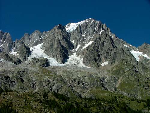
Driving down the Aosta valley I could catch a short look at Dent’d’Herens to the left. Grand Combin was hiding himself under clouds one more time. I was thinking about, what to do when reaching Courmayeur and felt comfortable with the idea just to hike around Val Veny and Val Ferret and take some pictures of Mont Blanc and Grandes Jorasses. The strong wind should be a good precondition for taking pictures with clear colours.
The highway from Aosta to Courmayeur is worth the 4,60 € toll. You drive from tunnel to tunnel and just at once leave another tunnel and there he his: the highest mountain of the Alps, Mont Blanc. I guess those Italian constructors knew the effect that this spontaneous view could have on some drivers, so they provided the highway with a huge solid emergency parking zone there. I parked my car in emergency of getting out and followed the mighty ridges of Mont Blanc southside. First with my eyes and second with my camera.
The impressions of this mountain area were not getting smaller by pure dimension when reaching Courmayeur some 15 minutes later.
A small road goes up Val Ferret in northern direction and offered fantastic views of Grandes Jorasses. I studied the mountains normal route from the valley and programmed my brain with the fixed plan, that climbing Grandes Jorasses will be a must do for my 2008 activities.
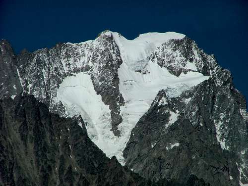
Exploring Val Veny to the south I witnessed a huge ice fall at the Mont Blanc Brenva face crushing down Aig. Blanche. Deeper inside the valley I had spectacular sights up on Mont Blanc south side with the famous Brouillard, Innominata and Peuterey ridge and the central pillar of Frêney.
At the end of Val Veny I catched a likely view at the not so popular Aiguilles de Trélatéte. "This might be a good goal for ski-mountaineering next winter", I thought.
After exploring both valleys by car and by foot all day long researching Grandes Jorasses and Mont Blanc southside I had a last view at the Jorasses from the upper Val Veny.
Then I used the Mont Blanc tunnel to drive into France and looked for a place to sleep in Chamonix. I checked in to one of the countless midrange hotels and went out for French red wine and some dinner.
The next morning I had breakfast on top of my hotel building and could witness a clear sunrise touching Mont Blanc northface into soft colours. The storm up there must have been extreme. I could see how the wind was pushing up the snow from the ridges some hundred meters high into the sky.
I took the tram to Montenvers – like a real good tourist – and enjoyed the looks at Grandes Jorasses northface, les Drus (with the missing "American direct") and the view at the sharp needles of Aiguille des Grands Charmoz. The Dome and Aiguille de Rochefort were also real eyecatchers.
It was Wednesday, 05.09.07 and I had to be back home again today. A few days of holiday were over now, but I enjoyed many hours.
Climbing around Saas Fee had been a highlight one more time and my research visit to Courmayeur and Chamonix gave the mountaineering experience a nice and relaxing finish.
I left Chamonix and drove through the Mont Blanc tunnel a second time to have a look at those impressive Italian southfaces once more.
Then it was time to say good buy. Not for long, I will be back ...


Comments
Post a Comment