


theronmoon - Dec 24, 2007 8:33 pm - Hasn't voted
Re: Oh YesYou bastard! You made it. I have been looking at the Bonita route for awhile too, especially for Buck. All I can say is I'm jealous, good work!
theronmoon - Dec 24, 2007 8:37 pm - Hasn't voted
Re: Oh YesGreat pictures too!
theronmoon - Dec 24, 2007 10:55 pm - Hasn't voted
Re: Oh YesHa, I just pulled a bloody thorn out of my arm at Christmas dinner. I would only do that ridge again if it burned, which I'm sure it will with all the arsonists around here.
theronmoon - Jan 3, 2008 8:19 pm - Hasn't voted
Re: Oh YesToday is 1-3-07 and my wife just pulled a 1/3 inch long thorn out of my shin 11 days after that hike. Didn't even feel it as she pulled it out. Now I have a even deeper respect for the eastern San Gabriels.
theronmoon - Dec 25, 2007 7:32 pm - Hasn't voted
Re: WTFWe'll I have a low slung corolla and I also have not climbed Sevaine. Sevaine, Buck, and Etiwanda are the only three I don't have in the east. I was actually planning on doing Rattlesnake that morning but i didn't get any sleep the night before. Merry Xmas man.

Travis_ - Jan 1, 2008 11:57 am - Hasn't voted
Re: WTFwhy not hike to San Servaine and Buck Point fron Icehouse Canyon over Etiwanda?
theronmoon - Jan 2, 2008 10:16 pm - Hasn't voted
Re: WTFI have thought of that as a backpack. Maybe this summer. Hey congrats on 100!
Travis_ - Jan 2, 2008 11:21 pm - Hasn't voted
Re: WTFthanks, I am trying to decide if I should set a goal of another hundred for 2008....
Travis_ - Jan 12, 2008 12:44 am - Hasn't voted
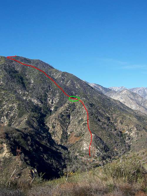
what about this route?Here is the route I am now thinking, it was mentioned in the HPS route page from Buck Point. Trailhead from the north end of Etiwanda Ave. What do you think?
Topo Map - Route from Etiwanda Ave
theronmoon - Jan 13, 2008 10:02 am - Hasn't voted
Re: what about this route?Yes, I have been looking at that route and a couple others on the south slope. From a distance it appears to be less brushy. I haven't been up close enough in awhile to really tell though. Your ridge is a goo middle point between Buck and Sevaine. You should give it a try.
Travis_ - Jan 13, 2008 10:42 am - Hasn't voted
Re: what about this route?I think I will try it out, here is the route in Google Earth, it looks like the firebreak is still there and it is fairly brush free.
GPS Tracks and more info I put together, including elev. profile
Comments
Post a Comment