Bull Of The Woods Trail (I, 2.0)
Trailhead: 2,883m (9,460ft)
Summit: 4,013m (13,167ft)
Vertical Gain: 1,431m (4,695ft)
Distance: 26.1km (16.2mi)
See
www.txmountaineer.com for original trip write-up.
![Looking Down the North Ridge from Point 13,045]() Sangre de Cristo Range
Sangre de Cristo Range2005.12.28 thru 2006.01.03
I love skiing! Skiing is what got me interested in winter mountains in the first place. My only problem is now that I like mountain climbing as well, my hobbies are somewhat at odds with each other; a lot of powder snow is great for skier Daniel, whereas it means increased avalanche danger to climber Daniel.
The St. Bart's Young Adult Ministry (SBYAM) had taken a ski trip, mostly coordinated by yours truly, to Summit/Eagle County Colorado. To make a long story short, we had a wonderful time with the best snow conditions that I have ever encountered! The snow was fresh and deep every morning, making for some great powder skiing, though my cousin who lives in Salt Lake still maintains that it couldn't be better than Wasatch powder. I'll definitely have to perform a "scientific" study at some point! I digress...
2006.01.04
So after a great week with much snow, skier Daniel went to sleep, and climber Daniel woke up in his place. Climber Daniel, who had planned to climb Mt. Elbert, CO, needed only to dig an avalanche test pit on the lower slopes of Colorado's highest to determine that it wouldn't be safe. My intended route was the South Elbert Trail, which has a slope leading up from a clearing at roughly 11,700' to 12,300' that likes to wind-load and is just steep enough to slide. While I was driving up, I could see a fairly consistent snow coverage on the mountain, which indicated that the slope in question would be a risk. A brief jog up the road between the trailhead and the Colorado Trail and a slight foray off toward a similar slope led me to the place where I would dig a test pit. I had to search around a bit for an open space between the trees, but quickly found a good spot. It didn't take long at all to find a layer of ~6" of consolidated slab on top of a "perfect" crust. Puting my shovel on top of the powder and slab, I didn't have to apply much force before it gave way. I ran back down the road and got moving toward my other objective for the trip; this isn't a Mt. Elbert trip report after all!
![Very icy conditions on the...]()
Several hundred miles to the SSE brought me just north of Taos, NM. Not sure what the conditions of the route up Wheeler Peak would be, I used the waning daylight hours to drive up a canyon to Taos Ski Valley where I would take a look at the Bull-Of-The- Woods route. Most people tend to climb from Williams Lake to the summit during the summer, but this time of year, that path crosses several avalanche runouts. I could see the North Ridge of Wheeler above me, and it looked to be windswept clean of most of the snow; I could hear the wind whipping about abouve my head and saw spindrift coming off of the ridge above, though it was only ~ 15 mph at ground level where I was. With just over an hour to burn, I decided to try and make it as close to the BOTW pasture as possible. I ended up making it all the way up, though the trail ranged from several inches of solid water ice, to dry dirt, to 6" deep snow. Based on my quick progress up (45 minutes), I made the decision to try for the summit in one long push the next day; instead of camping in La Cal Basin, as it was an option, I chose to get better and warmer rest in a hotel. Plus, that would allow me to watch the NCAA National Championship!
2006.01.05
Rising early the next morning, I ate a bit of breakfast while watching the news and packed my lunch for the day along with some snacks to keep me going; gaining over 16 miles and almost a vertical mile would likely make for a difficult day! I got to the trailhead just as the sky became bright enough to see without the aid of a headlamp. I pulled on may pack and got moving along the track I had followed the day earlier. I carried quite a bit of equipment as I didn't know if the wind today would be as blustery as the day before, but I was fully prepared just in case. With the heavier load on my back, it took around an hour and fifteen minutes before I made it to the junction with the Wheeler Peak Trail on this occasion. I should also mention that my trekking poles were indespensible on this morning as the colder temperatures had made the water-ice extremely slippery; I almost took a spill more than once!
Once at the snowy saddle, I took a trail leading to climber's right (not the snowmobile track if you're keeping score) and soon was climbing up the deepest snow of the day. The prior day, I had run into two hikers who had gone all the way out to Fraser Mountain. While they thought I was crazy to be considering a winter climb of the north route up Wheeler in a single day, it actually and ironically turned out to be their efforts that allowed me to succeed. The had taken turns breaking trail up the snowy trail below BOTW Mountain, which left a great track for me to follow without the considerable effort that it otherwise would have been.
![Taos Ski Area and Old Mike...]()
I arrived in the sunlight along the ridge to take my first true break of the day. I had been stopping every 15 minutes to rehydrate, but I knew that I neede to stop to refuel at least every two hours. On this occasion, I had an entire Powerade as well as several handfulls of Fritos. I always struggle with my eating & drinking at elevation, but I came up with a pretty good plan on this trip; I actually did stop to rest and eat! After twenty minutes or so, I put on some more sunscreen and loaded up to get moving again. As I climbed above the saddle, the tracks from the other hikers waned before the summit of Fraser mountain, leaving me to wallow in deep, drifted snow for a stretch. This is where I learned to truly appreciate the efforts of the other hikers!
By the time I regained the ridge and the trail, I was definitely panting and sweating from fighting with the snow. Considering this, what a surprise it was, coming to a completely snow-free ridge that had been cleared by the wind! I was able to practically jog up the white trail leading along the ridge with such great conditions. I got into a groove, so after what seemed to be a very brief time, I had walked up to the summit cairn of Fraser Mountain.
From my perch, I was able to see most of the remaining route across La Cal Basin up to Point 13,045'. I also saw a large herd of big horn sheep that had been grazing on the summit before I arrived. I started trying to take pictures of them, but they seemed spooked both by me and by a rumbling noise that started to grow louder and louder. I could almost feel the ground start to shake and for an instant, I thought that I was in an earthquake. Now growing spooked myself, I looked around expecting the mountain to start coming down rock by rock, when I saw a C-130 blaze past me as he tore out from the valley to my west. As the aircraft sped past through the saddle, I was close enough to see the pilot practically at my eye-level! I was so shocked at the whole situation, that I didn't initially think to take any pictures, though reason soon returned. I held it up quickly enough to capture an amusing picture of some of the sheep running away from the loud noise, with the C-130 in the frame off in the distance. This is definitely one of my favorite photos to date! Dazed and confused from one of my Lockheed Martin products in action, I started walking again toward the ultimate day's goal.
![Bighorn Herd near La Cal Basin]() Peaceful & Serene
Peaceful & Serene![C-130 & Sheepish Residents of La Cal Basin]() Stampede!
Stampede!
I quickly gave up much of the elevation that I had gained as I descended toward La Cal Basin; instead of taking the standard trail, which was buried in snow by this point, I simply followed the path of least resistance, while at the same time being careful not to trample the alpine vegetation. Some small trees began to appear as I found what I though to be the standard route through this area. Around the trees, the snow had drifted quite deeply, so my progress slowed considerably as I began swimming again through the wintry conditions. I grew tired rapidly and also became frustrated at my lack of forward movement.
Eventually, I came to a point where a poorly defined rib of boulders ran up toward the ridge. Since the snow was not covering the tops of the rocks, I realized that I could probably move faster up this way and avoid expending any more energy than necessary. I was right! Progress was much faster up along the right side of a frozen creekbed. I quickly gained back some of my elevation before finding the logical place to cross the basin near a small hill composed of boulders. Here, I took another break for some lunch (a cold small cheesburger from Mickey D's and another blue Powerade) and much needed rest. While I feasted, the sound of a nearby pack of wolves brought some discomfort; maybe they had a taste for cheeseburgers as well! I didn't stop for as long during this break and soon began climbing up out of the basin toward Point 13,045' at its head.
![Point 13,045 at the head of...]() La Cal Basin
La Cal Basin
I climbed almost directly up the icy slope on the south side of the basin, as I aimed for the nearest switchback of the normal trail. By this point, the day was starting to catch up with me and my pace had slowed down noticeably. Upon gaining the trail, the slope made for easier going, but the wind-scoured hard pack was much slipperier than on the other portions of the route. I kept up a steady rate of ascent and slowly picked my way up to the top of the ridge.
![Icy conditions below Mt....]() Mt. Walter
Mt. Walter
The main part of the ridge was completely devoid of snow since its aspect saw the Sun virtually all day long, though up toward Point 13,045', there was a shining steep slope of obvious ice. I hiked closer to the slope before stopping to put on my crampons and pull out my axe; this was the only "technical" portion of the day's long climb. The snow was to hard to use French technique with much comfort, so front-pointing was the order of the day for a 200 vertical foot stretch. Enjoying the adrenaline of actually getting to use my crampons and getting thoughroughly baked by the light reflecting off the ice, I made quick work of the fun, albeit hot section.
![The Sangres unfold from the...]() Above 13,000'!
Above 13,000'!![Baldy Peak & Mt. Phillips (my...]() Philmont Scout Ranch
Philmont Scout Ranch
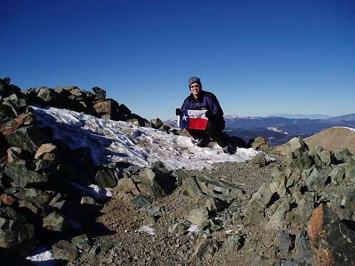
Once at the top of Point 13,045', the remaining route to the summit was majestically in view, backlit by the brilliant Sun. Although it looked like a hop, skip and a jump to the summit, it actually took around 35 more minutes because of some slick, icy sections along the ridge; the exposure was never too bad, but I still wouldn't have wanted to take a ride on the slide down the east side! I made it to the summit of New Mexico in just over six hours from the trailhead.
Jacko finally emerged from the slight warmth of my pack, and we spent a good amount of time enjoying the enchanting view from the top of the Land of Enchantment. I munched on several more handfulls of Fritos and another cheeseburger as it was again time for a nutritional break. I spent 40 minutes relaxing on the summit, but after the Lone Star had flown over this cold peak, the urge to beat the sunset kicked in. I resolved to not stop for pictures on the way back down, but if you know me at all, you can probably guess how well that worked...
The descent was terribly unremarkable, though I continued to push fluids to keep my energy up and prevent cramping from the long day I'd already had. The climb back up Frazer Mountain was demoralizing, but it did not take as long as I was expecting. After making it up the last uphill stretch of the route, I plodded down toward the trailhead as quickly as my legs wanted to go.
I finally reached BOTW pasture, where I started to see people again. After a day of complete solitude, it was odd to encounter almost a dozen hikers so close to sunset. Carefully walking down, I finally bit it on the ice, though I arrived no worse for the wear at my car 10:30 after starting the day. My timing was perfect as I didn't have to use the headlamp at all. From dawn till dusk this was definitely the strongest, longest day I've had hiking in the hills.
![Au sommet du Wheeler! - 05...]() Where's Jacko?
Where's Jacko?


Comments
Post a Comment