Overview and Stats
18 miles / 11 hours RT, approx. 4500 ft elevation gain, "terra incognita" terrain in the area of Hells Kitchen which hardly ever sees people even in summer.
Hells Kitchen Peak (11,056)
![Misty morning on Smith and Morehouse Reservoir]() First glimpse of Hill 10,348
First glimpse of Hill 10,348![Open woods on the slopes above Broad Canyon]() Skinning up through the open woods above Broad Canyon
Skinning up through the open woods above Broad Canyon
Our
reconnaissance tour last week stopped less than a mile short of the 11K+ highpoint of Hells Kitchen Ridge. The high country ahead looked irresistible, and we planned to return to explore the ridges ahead. But this time, we ought to take a shorter route up here, kind of along the line of our last week's descent track.
We park near Weber Riber bridge on SM Road. The road to the reservoir dam is dusted with soft overnigh snow, and skiing is fast. No snowmachines here yet, they are late birds a usually. Half-way across the frozen lake, our goal comes into view, a tall timbered ridge with twin white glades near Hill 10,348. Time to head straight up there!
![Smith-Morehouse Reservoir, 2,000 ft below]() Smith-Morehouse Reservoir, 2,000 ft below
Smith-Morehouse Reservoir, 2,000 ft below![Hells Kitchen in sight!]() Hells Kitchen underfoot, with North Long Mtn closing the view
Hells Kitchen underfoot, with North Long Mtn closing the view
In a few minutes, we cross Broad stream and our downtrack from last week's, and continue ascending to the South-East. An hour and a half later, the forest appreciably tins, and we can glimpse the reservoir behind, a couple thousand feet below. The ridge must be near!
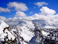
And soon, a wide panorama opens to the South, with Erickson Basin across the deep gash of SM Gorge, and Hells Kitchen to the SE. The ridgetop is the usual jumble of drifts, and a good portion of our track skirts them on the North side, but we return to the rim again and again to soak in the ever-improving views. From Hill 10,348, the North-side bowl we used for descent last time comes into view. We aim for our old track now, but first, it is time to use the moment of fleeting sunshine & to stop for a snack.
![View East from Hill 10,348]() Hill 10,348, the first highpoint of the day
Hill 10,348, the first highpoint of the day![First glimpse of distant Hayden Peak]() Cliffy Hayden Peak to the East
Cliffy Hayden Peak to the East![Passing Hill 10,770 on Hells Kitchen Ridge]() Cone Peak to the South
Cone Peak to the South
Countouring the timber country bowl at 10,400, for a few minutes I have this nostalgic home-country backwoods feeling. It is just the trees and little meadows and no mountains in sight. Then, just as abruptly, we switchback up Hill 10,770, and the whole range opens up around us, from Hayden Peak in the East to the distant Wasatch Range in the West. This is where we turned around last Sunday. Today we reached the same spot 3 hours earlier ... time for the ambitions to play :)
![Hells Kitchen Ridge and distant Watson (11,521)]() Hells Kitchen Ridge, and Watson Mountain beyond
Hells Kitchen Ridge, and Watson Mountain beyond![Gentle section of Hells Kitchen Ridge South of Hill 10,867]() Hells Kitchen Ridge past Hill 10,867
Hells Kitchen Ridge past Hill 10,867![View South across Hells Kitchen Basin]() Hells Kitchen Basin
Hells Kitchen Basin
We are less than a mile from Point 11,056 now, and the ridge gently rolls, and the altitudes stay in 10,800s range ... until we get to a little rocky know at 10,890 elevation. Suddenly the route does not look so mellow anymore...
![Watson (11,521) and North Long (11,380) Mountains]() Watson (11,521) and North Long (11,380) Mountains
Watson (11,521) and North Long (11,380) Mountains![Final section of North Hells Kitchen Ridge]() Final quarter mile of the ridge leading to Hells Kitchen Peak
Final quarter mile of the ridge leading to Hells Kitchen Peak![Hells Kitchen Pass and North Long Mtn (11,380)]() Hells Kitchen Pass and North Long Mtn
Hells Kitchen Pass and North Long Mtn![Bypassing Gendarme 10,890 on the way to Hells Kitchen Peak]() Bypassing rocky knob at 10,890
Bypassing rocky knob at 10,890
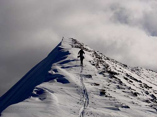
I try to boot the cliffy knife edge on the South side of this little gendarme, but it feels way iffy, and after some deliberation, we decide to traverse on the East side instead. Whew! Now the ridge starts gaining altitude at last. Another, much eaisier, 11,000-footer knob is easily bypassed on the left too, and minutes before 2pm, we ski to the top of Hells Kitchen Peak!
![Hells Kitchen Peak (11,056)]() Hells Kitchen Peak!
Hells Kitchen Peak!![Beginning of traverse of East slopes off Peak 11,056]() Start of descent to Hells Kitchen Pass
Start of descent to Hells Kitchen Pass
Two tiers of reddish cliffs block our way down to Hells Kitchen Pass, but the East slopes are less steep here, and we ponder the relative advantages of dropping to the East base of the pass (with a 200 ft loss) vs. a high traverse. The snow is wind-crusted here and it feels just a tad precarious, but the high treverse is definitely a possibility. In a couple minutes, it is back to soft snow and balmy sunshine at the pass. Time for another break, and to chart our course for the remaining hour or two before we must start descending.
![ZeeJay traversing underneath the cliff tower of Hells Kitchen Peak]() Traverse under the cliffs towards Hells Kitchen Pass
Traverse under the cliffs towards Hells Kitchen PassNorth Long Mountain (11,380)
![Hells Kitchen Pass (10,800) and South Ridge]() Hells Kitchen Pass - time for lunch break :)
Hells Kitchen Pass - time for lunch break :)![Hells Kitchen Peak (11,056)]() Looking back at Hells Kitchen Peak
Looking back at Hells Kitchen Peak
We have to choose between descending from the pass into Hells Kitchen basin, or taking the wide West Ridge of North Long, which closes the basin on the far South side. Gotta make up our mind in the neighborhood of Point 11,286, once we see the upper portion of the ridge.
We start from Hells Kitchen Pass on wind-crusted slopes, with the new snow bonding only tenuously in place. In fact I choose to boot a short steeper section with sticking out rocks. But very soon the snow becomes softer, and it is smooth sailing all the way to 11,286
![South Hells Kitchen Ridge]() Breaking trail at South Hells Kitchen Ridge
Breaking trail at South Hells Kitchen Ridge![Long (11,342) and North Long (11,380)]() Long and North Long Mountains
Long and North Long Mountains![Long Mountain (11,342)]() Rob on the highest point of South Hells Kitchen Ridge (11,286)
Rob on the highest point of South Hells Kitchen Ridge (11,286)![Mid Fork Weber River Basin]() Basin of Middle Fork Weber River
Basin of Middle Fork Weber River
A cairn greets us at this high point, which probably does not deserve to be called a mountain since there is very little drop separating it from North Long further to the South. The ridge ahead reminds me of my and Rob's ascent to nearby Long Peak two years back. Same cornice to the East, sticking out rocks to the West.
![ZeeJay with the cairn of South Hells Kitchen (11,268)]() ZeeJay with the cairn of South Hells Kitchen (11,268)
ZeeJay with the cairn of South Hells Kitchen (11,268)![Hells Kitchen and Jean Lake]() Hells Kitchen and Jean Lake
Hells Kitchen and Jean Lake
But this time the snow isn't as stiff and the angle not as steep either. Very soon we skin to the twin high points of this tall and long mountain. Too my surprise, Judy's GPS shows that the peak is still one sixth of a mile ahead, though! Of course this waypoint is at the cross mark at the junction of East and West ridges, marked at 11,342 elevation. The true high point turns out to be higher! (At least 11,380 according to our GPSs).
This makes it actually taller than the "main" Long Mountain, and the highest point we've ever skied to in this part of the Uintas. And it is definitely the highest elevation for me since the broken-ankle accident in July. Just last Wednesday, we had plans to climb even higher on Timp, but bailed in zero visibility and gale off the Glacier Saddle, somewhere in the 11,350 neighborhood.
![Ascending North Ridge of North Long (11,380)]() Approaching North Long Mountain
Approaching North Long Mountain![Skinning up North Ridge of N Long (11,380)]() Skintrack up North Ridge of North Long Mountain
Skintrack up North Ridge of North Long Mountain![Looking back from North Long s North Ridge]() Looking back from North Ridge of North Long Mountain
Looking back from North Ridge of North Long MountainDescent to SM Creek
![Upper West Ridge on North Long]() Upper West Ridge
Upper West Ridge![NW Slopes of North Long (11,380)]() North-West aspect of North Long
North-West aspect of North Long
The views from North Long are breathtaking, but the time is almost 4 pm and we are in a hurry to get out, to find a route down the steep sides of Smith Morehouse gorge & to locate the trail there before dark.
We take off skins at a little notch just North of Point 11,342. West Ridge is wide and fairly mellow, although the snow is wind-scoured in many places. But it quickly turns into great powder between the trees below.
![Looking back at the West Ridge of North Long]() Mid-section of West Ridge, looking back at the peak
Mid-section of West Ridge, looking back at the peak![Lower West Ridge of North Long]() Glades of Lower West Ridge
Glades of Lower West Ridge
At about 10,500 level, the ridge becomes almost flat for a while. We ski directly into the low afternoon Sun, and we even have a few moments of sticking snow. Then the ridge starts dropping again. Smith-Morehouse Creek is very, very deep below on the left, but, fingers crossed, this ridge could get as almost there. A few fun glades below 10,000 contour, and then the woods start closing around us.
![Entering the gully of South Hells Kichen stream]() Map session at the start of a tricky descent into SM Creek
Map session at the start of a tricky descent into SM Creek![Tall roadbanks near SM turnoff]() Road from the trailhead ... Sierra-quality snowbanks!
Road from the trailhead ... Sierra-quality snowbanks!We pick a kind of least-resistance, open-trees course around the drainage. The map suggests that it less steep on the left, but that's where the thicket of trees is the least inviting. A few minutes later, I reach the top of the cliff just above 9,200 contour. But it is clear that we can bypass it on either side. Whew!
A switchback to the right crosses sun-softened snow with rollerballs, then we drop into the shadow of the valley and traverse an open crusted section - and voila, here comes SM Creek, open trees, 3 or 4 inches of light powder on crust, just perfect. I couldn't find the trail though, but we know that we'll spot it at meadow's edge below Erickson Creek - and we do. It is still twilight when we cross the creek bridge and roll into Ledgefork campground.
We stop at reservoir shore to finish the last cap of my now lukewarm Red Brook tea. The stars come up, one after another, then all the uncounted myriads of winter stars. No Moon until much later tonight, but it is all smooth glide to our car now.
The highest-altitude Western Uintas traverse is done! And we are double lucky when Judy's Subie starts just fine, despite an interior light left shining :) Now it is just one more photo-op with the 8-footer snowdrifts of the trailhead road, and we are on the way home.
GPS track of the route
By ZeeJay


Comments
Post a Comment