Setting the Stage
I guess I knew that it would be an adventure when I signed up for it. What trip with
Bob Burd hasn’t been? There are probably quite a few SPers out there that have experienced an adventure while on a Bob “sponsored” trip. In fairness to Bob, he gathers the “ingredients” but makes you responsible for doing your own “cooking”. The mountain we were chasing is commonly known as Mt Carl Heller, a remote 13,200’ peak on the High Sierra crest just north of Mt Whitney. The approach was up
George Creek, “a difficult cross-country route – one of the classic bushwhacks of the High Sierra”, as quoted from R.J. Secor’s “
The High Sierra – Peaks, Passes, and Trails”. The route up to the summit was via the East Ridge, a mixed class 3/4 climb with promises of snow and a steep snow coulior at the very end. Yup, all of the ingredients were there for the first real Sierra challenge of the year.
Five Adventurers
Five of us left the town of Independence shortly after 3AM – Bob,
Matthew Holliman,
Glenn Gookin,
Ryan Spaulding, and I. Four of us had been up George Creek before so only Ryan didn’t know what he was in for. This weekend would be crowded as far as George Creek goes – confirmed two parties of backpackers and 2 more day hikers hoping to get
Mt Williamson,
Mt Trojan, or
Mt Barnard. Since the George Creek approach is only open for a month during the spring as it lies within the
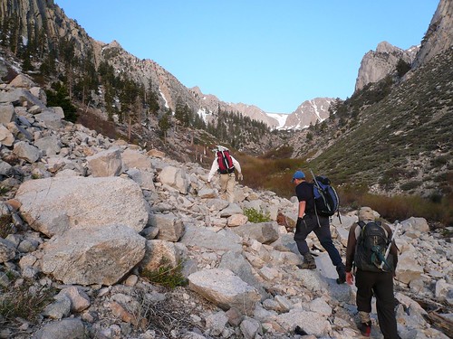
Bighorn Sheep Zoological Area, everyone hiking this weekend was trying to summit mountains that usually take days to hike into. After a grueling drive up the 8 mile dirt road, we finally reached the end of the line. Donning our day packs, we began the adventure.
Then There was Four
We moved out rather quickly around 4:30AM, the five of us joined by two fellow day hikers. The first ¼ mile is actually quite pleasant after the initial 30’ of dense forest you force your way through. The use trail peters out as we look for a log to cross the fast moving stream for the first time. Four more crossings, a bit of bushwhacking, and the sun rises as we leave the narrow canyon and begin climbing up the south side of the broad valley. The steep snow tongue that leads to the common plateau between Mt Barnard and Mt Trojan comes into view as we drop back to the bottom of the valley at the junction with a side canyon. We had lost Matthew sometime back as he struggled with a particular crossing but Matthew always catches up. As we started back up the south side of the valley, I see Ryan has somewhat fallen back but I wasn’t too worried as he’s a regular ultra marathoner – he’d catch up. The problem with George Creek is that there’s no set trail – there are use trails here and there but often they’ll peter out or you’ll find yourself in the middle of brush. Three of us reached the camp (our term for a nice flat are in trees that’s the first habitable spot in the canyon) followed 10 minutes later by Matthew. We wait for 30 minutes but no Ryan and we decide to push on.
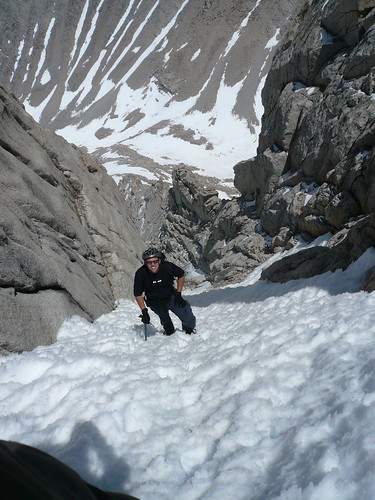
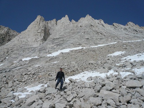
Now It’s Only Three
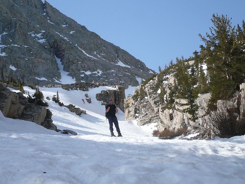
Our route now takes us away from the main valley and up a side valley that is anchored by Mt Carl Heller. The hike starts out narrow and brushy but we escape by climbing a series of ledges on the north wall. The brush thins as we descend back down and put on our crampons for snowy remainder of the hike up. We march steadily up on top of the snow covered creek, up some more granite slabs, and then around Lake 3400 to the base of Carl Heller. Bob is way ahead of us, Glenn and I are keeping roughly the same pace, and Matthew is uncharacteristically lagging behind. By now, both Glenn and I are panting a bit and sporting some pretty good headaches but the East Ridge beckons on. This is Bob’s third try for the mountain – each preceding attempt dissuaded by the steepness of the coulior and the possibility of too much snow on the exposed ledges. We climb the initial 50’ class 4 headwall and join Bob for another break. Time ticks away as we finally spot Matthew moving back down the canyon, evidently deciding today wasn’t the day to attempt the mountain.
“It’s Dicey”
I had previewed Bob Rockwell’s
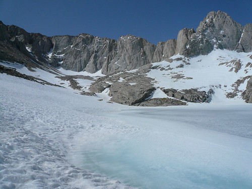
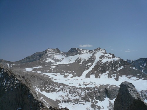
pictures of his successful climb six years back and knew that we were in for a lot of fun climbing. And so we were with sustained and highly exposed class 3 slab and crack climbing with class 4 moves thrown in here and there. At one point, I took pause at a particular exposed class 4 move with nothing but big air below a rather tenuous foot placement. We continue to move upward and hit the final ridge gendarme before the snow couloir. Bob probes the north facing snowy, slanted ledge that falls to over 1000’ of nothingness and finds it acceptable (his method of shaking the snow off his shoes over thin air badly spooks both Glenn and I). He pushes on, promising to call back with the news of the route further up. This he does but throws in the word “dicey” sending Glenn (the best climber among us) and I looking for an alternate path on the southern flank. After exploring a class 4/low grade class 5 route, we are finally stymied and find ourselves 30 minutes later back looking at the snowy ledge again. Bob pops his head out from the summit only about 500’ above us and we now learn that the snow coulior was actually easy compared to the rest of the climb.
Triumph for Two
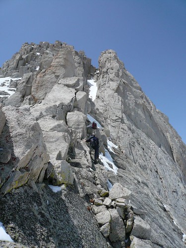
We cross the snowy ledge with ease (the snow is deep and secure) and get to a narrow foot wide section with more snow. Glenn goes first and effortlessly crosses the ledge to a more secure platform. I get into position and waver at the shallow left hand finger hold and my now wet boots on a somewhat slick rock surface. I’m one move away from a secure handhold and relatively decent foothold but the exposure is simultaneously exhilarating and frightening. A five minute period of indecision and I ask Glenn to belay me – the risk isn’t worth it. It takes him about 10 minutes to set up the anchor and toss the rope to me. With tension on, I have no trouble crossing over and grabbing the handhold. I keep moving up while Glenn puts the equipment away. We hit the coulior, put the crampons on, and pop out at the top of the couloir fairly quickly. A bit of route finding up the final 100’ of ridge line and we find ourselves on top of the world. Bob has left us a message over an hour earlier – “going down now”. We have a long way to go to return but for the moment we relish in our triumph climbing a difficult peak using a difficult route.
Pain and Suffering
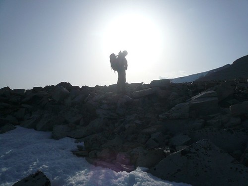
The good news is the descent route is off a snow free, west facing class three chute. The bad news is that it’s on the wrong side of the Sierra crest so we know we’re in for a lot of pain on the return trip. The descent is fun over blocky granite but with the adrenalin wearing off, both Glenn and I are beginning to feel the fatigue, the altitude, and the dehydration. We slowly make our way down, navigating through the granite escarpments that protect the west face, to the snowy gentle slope rising from Wallace lake. I begin guiding us north toward Vacation Pass, visible as a steep, scree covered chute rising almost as high as the peak we just descended. I talk Glenn into descending all of the way to the lake (it’s only 50’ further down!”) to rest and rehydrate. Using the ice ax, I break the ice from the surface and fill our water bottles. 10 minutes later we’re on our way with Glenn leading the way … 20’ at a time. By 6:30PM, we stand on top of Vacation Pass with only 6 miles and all of George Creek ahead of us.
The True Meaning of George Creek
Snow on this side of the pass allows us to make quick time, plunge stepping 2 miles and almost 3500’ in 90 minutes. A quick break at the camp after a nice conversation with the current occupants and we continue on our way. Head lamps on now, we work our way through brush and trace trail to the side valley where I last saw Ryan. We continue on, somehow never stumbling upon the trace trail we used coming up. A cairn marks a spot that looks like our morning crossing but darkness shields the key terrain features that would solidify our find. An hour and a half of brutal thrashing through thick willow and aspen groves gets us to the true crossing point and we pick up the trail. It is now 10:30PM and we are already talking about a bivvy – we’re exhausted and stumbling has become routine for me. We look for the next crossing and lose the trail, easy enough to do in the daylight at this spot. We force a crossing and fight through more willows into nasty, thorny brush – the trail must be here but it isn’t! We force back across stream and I recognize enough features to know that it isn’t on this side either. It is now midnight and we call it – daylight is needed to find our way home. It’s very discouraging since we know that the car is less than two miles from our position. We settle in for what we know will be an uncomfortable night.
Epilogue
As unplanned bivouacs go, it was probably the best of a bad situation. Although we didn’t get much sleep, the ground was reasonably flat, it was a windless night, and the 7000’ elevation was only mildy cold. Dawn came soon enough and we headed back across stream, only to find the use trail 10’ above the thorny brush we avoided only 6 hours earlier. 45 minutes later find us at the car and a note from Ryan and Bob. At 7:30PM they had started walking down the road and the note told us to pick them up on the way down. They were fortunate that some casual explorers who had been at the trailhead picked them up on the remote dirt road – 8 miles of walking to the highway is a long ways after doing George Creek. We meet them back at the motel, beg off on the remaining part of the trip, and head home to L.A. after welcome showers and a hot breakfast. And I don’t feel too bad about not climbing a peak on Sunday. After all, the
2008 Sierra Challenge is just around the corner with plenty of new opportunities to adventure with Bob.
More pictures


Comments
Post a Comment