Preamble
Mounts
Gardiner and
Cotter are two of the three
Sierra Peak Section or SPS triumvirate peaks that overlook Gardiner Basin,
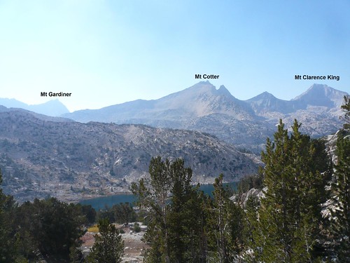
Clarence King being the third. Named after three members of the
1864 California State Geographic Survey team, none of the peaks break the 13K mark but all three have craggy, imposing features. I had been interested in climbing Gardiner for several years after reading about the knife edged north ridge that one must master before reaching the true summit. Having perused
Bob Burd’s trip report on his recent solo day hike of the peak from the west (Road’s End), I enlisted a friend to give it a try and debated whether I should approach from the east or west. The east approach, although slightly longer, had the benefits of a shorter drive (important when leaving work in LA) and starting higher (but requiring travel over Kearsarge Pass). The clincher for approaching from the east was the possibility of adding Mt Cotter in as a second goal – a feat previously accomplished by
Matthew Holliman from the west. My hiking partner dropped out but I decided to complete the trip as a solo hike.
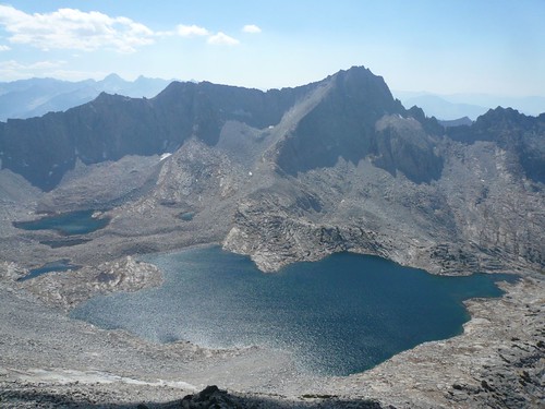
Mt Gardiner from Mt Cotter (Sep 08)
The Approach
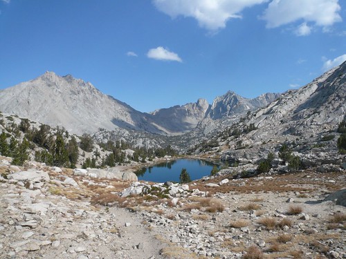
I awoke in Onion Valley after driving up the night before and began hiking at 3:15AM. I quickly made my way up the dark but very familiar Kearsarge Pass trail pausing briefly at the pass before dropping down to Charlotte Lake. By the time I reached the lake, the first hint of daylight had illuminated the mountains. Quickly skirting the lake, I came to the end of the maintained trail and descended via the abandoned Gardiner Pass trail. I quickly lost the trail in the poor light but travel was easy in the forested slopes of Gardiner’s lengthy East Ridge. Good terrain and animal trails made the traverse to the SE spur straight forward, without the expense of losing more altitude. I dropped into the wide, sandy chute just east of the spur ridge and began hiking up. Other reports had posted warnings of this chute but I found it quite easy with many stable rocks allowing quick elevation gain. I shot left for a notch in the ridge and climbed out of the chute. Just before I got to the notch, the noise of a rock slide behind me caused me to turn around. I glimpsed three bighorn sheep loping across the ridge next door, the first sheep I’ve ever encountered in the High Sierra.
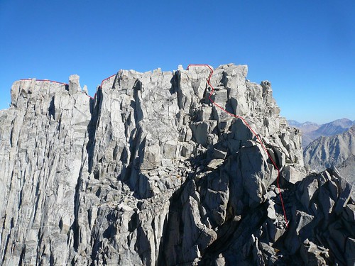
Mt Gardiner’s North Ridge (Sep 08)
Mt Gardiner
My hope had been to cross the SE ridge and traverse / climb the next bowl to the East Ridge gaining the important lower South Summit, the gateway to the summit. Cliffs blocked the traverse and forced me to climb the SE ridge to near the top of the Gardiner’s “east peak”. The crest line between this peak and the South Summit looked easy in photos shot from the South Summit. However, these pictures miss the deep, vertical notches along the crestline. The traverse just below the ridge to what looks like a gap is surprisingly easy – good rock and gentle slopes. I bypass the notches from below just missing the glaciated cliffs that almost reach to the top of the ridge. In minutes I’m at the South Summit looking over the final notch to the 300’ L-shaped knife edge ridgeline that leads to the true summit. The task looks daunting but an
excellent drawing in an old Sierra Club report had prepared me well. After some Class 3 and 4 scrambling, I found myself at the top although not without briefly pausing at a couple of highly exposed spots. The views were spectacular and I studied my second goal, Mt Cotter, on the other side of the basin with Clarence King just north of it. The return to the lower South Summit took minutes from where I climbed down to the top of Gardiner’s East Chute.
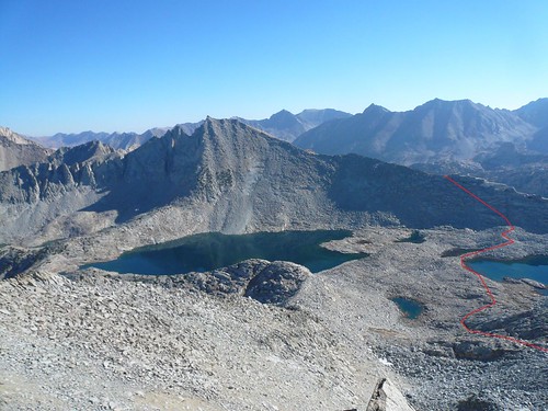
Mt Cotter (Sep 08)
Mt Cotter
The top 2/3s of the East Chute is perfect for a boot ski descent as it’s composed of sandy scree but I’m slowed down by a moraine near the bottom. Soon I’m seated at the highest of the Gardiner Basin Lakes and enjoy a quick lunch while surveying the route up Mt Cotter’s South Ridge. Although the climb was interesting and easy, I got my second surprise for the day. The ridge that I expected to be an easy slog to the top is composed of a mix of large and very large blocks. Seems like I’ll get more scrambling in today than expected which is just fine. Weaving on and off the ridge, I soon found myself just below the summit pillars. Supposedly there’s a class 3 approach to the top but it wasn’t obvious to me so I attacked the summit block directly in what turned out to be a Class 4 line. Once again the views are astounding as I looked back at Mt Gardiner and over Cotter’s lower north peak at Clarence King. Looking southeast, I survey both Rae Col and in the distance, Glen Pass, two of the three obstacles I still needed to overcome. I’d been hiking for 11 hours by now and still had a long ways to get back to the car.
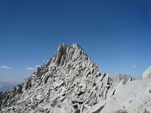
Mt Cotter’s summit (Sep 08)
The Return
Once again, the descent is better than I hoped for (I did find the class 3 summit route), composed of mostly sandy scree on the upper half and granite ledges on the lower half. I dropped into the 60 Lakes Basin and aimed for a group of tents that I guessed are near the trail. Striking up a short conversation with a couple of backpackers, I obtained the necessary directions to find the trail. They’re surprised that I’m day hiking as it typically takes a couple of backpacking days to get into the basin. It’s almost 15 miles back to the car but all on good trail. The first two miles up to Rae Col was relatively easy and I obtained glimpses of Fin Dome just north of the Col. Just briefly I’m tempted to climb the several hundred extra feet to bag this “peak” but fortunately common sense interrupted my thoughts. The vibrant colors of Dragon Tooth and Dragon Peak dominate the east skyline of what is one of the prettiest areas in the High Sierra. I descended the remaining mile or so to the Rae Lakes Basin, meeting the John Muir Trail by the largest of the lakes. Turning south on the JMT, I began the long climb up to Glen Pass almost 1500 feet above me. The sun is near setting when I topped out on the pass and dropped down the south side. One more pass to go.
Black Mtn, Dragon Tooth, and Dragon Peak (Sep 08)
Postscript
The final struggle up Kearsarge Pass was long and tiring as was the descent to the car. The east side of the pass is very pretty with the numerous lakes dotting the canyon but on this trip I saw none of it since both the ascent and descent were done by headlamp. By the time I stumbled back into the parking lot, I was totally spent having been out for almost 19 hours, clocking in something like 29 miles and well over 10,000’ of elevation gain (and loss). But all worth it to visit one of the most stunning regions of the High Sierra.
More Pictures
Looking back from Rae Col (Sep 08)


Comments
Post a Comment