DISCLAIMER
This trip report has A LOT of pictures and may load a little slowly. Please have patience. I think...
hope...that some of the pictures are worth the wait.
Day 1 - Zion Bygones (also Prologue)
Any day of the year if you were to give me five days to spend in Utah you would find me jumping for joy. And yet, as I departed Las Vegas up I-15 towards St. George I was never more down. After hitting up Humphreys on St. Patty’s day I met up with over twenty kids who had flown infrom Boston to partake in a four day romp of a bachelor party. Sunday I procrastinated in my room while everyone else left, one by one, two by two, four by four, on their flights back home. Part of me wanted to just fly back with them. Checking out of the Trump Tower by myself was one of the most melancholic experiences of my life. Mentally, I was not quite ready to transition from nonstop partying to a week of desert solitude, then the customary long, lonely drive across the barren heart of the country.
While in the planning stages I debated what to do with my week off from work post-Vegas. Initially I planned to hit up the ultraprominents of Southern Arizona, but as my vacation approached I began to lean more and more towards Utah. I had been to Zion and Bryce as a kid, visited Arches and Island in the Sky between 14ers three years before, but it was two years ago, driving back from Baker, Nevada on I-70 at 80 mph through a San Rafael Swell bathed in the glow of a brilliant sunset that I truly fell in love with the place. I had not returned since, and while the Southern Arizona plan appealed to my head and my sense of ambition, Utah appealed to my heart, to my soul.
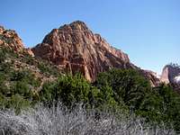
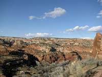
Still, I was an unhappy camper as I got up groggily Monday morning in Mesquite, Nevada. I had not slept much the past four days, and now for today I had planned for myself a 15 mile hike, albeit with only 1000 feet of elevation gain. I arrived late at the trailhead in the Kolob Canyon section of Zion around 12:30, concerned about making it back to the parking lot before dark. I fast walked through the sparse desert ridge that marks the beginning of the La Verkin Creek Trail. As the path descended towards the creek itself several openings in the trees provided glorious views of the magnificent walls of the Kolob Canyon.
More downhill. If I could walk any faster I’d be jogging. The trees were denser now, as the trail wound its way around Timber Creek, crossing it countless times. The sun was out, the air was dry, mellow, and perfect, but the scenery was getting monotonous. I was impatient as one creek crossing begat another. Less than halfway on the way to Kolob Arch, three miles to be precise, the trail was supposed to make a 90 degree turn to the left, while entering the La Verkin Creek drainage. Was I there yet? Was I there yet?
Soon I was. The trail pivoted eastward, and out opened up a completely new face of the intricate Kolobs, a view, I presume, not visible from the park road. Was this a sign of progress, I hope? Would I complete the hike before dark? Was this real wilderness yet? Would I rather be sitting poolside, sipping a Pina Colada? All worthy questions as I raced towards a break in the canyons ahead.
The trail was traversed mostly flat and open land. La Verkin Creek roared loudly to my right. I entered the canyons. Despite the rush I took time to notice my surroundings, the sheer canyon walls on both sides, how they seemed to change with every step, every angle, every perspective.
![Kolob Arch Sidetrail]() Side Trail Side Trail |
![Kolob Arch Sidetrail]() Side Trail Side Trail |
At last, the side trail for Kolob Arch, now only half a mile away. But I couldn’t find it. Where was it? I followed the side trail as it narrowed along with its accompanying side canyon. At one point it seemed to disappear at a creek crossing. With the canyon narrowing on both sides I struggled for ten minutes or so to find the trail. Finally, the terminus. The arch itself, though the second largest in the world, was hardly impressive from this vantage point. Sitting high above on a cliff face, it seemed remote, aloof, but mostly just blocked by trees. More impressive was the thin white strip to its right, a gorgeous, tenuous, waterfall defying the canyon wall. I tried to capture the drama with my camera. I was unsuccessful.
![Kolob Arch]() Kolob Arch Kolob Arch |
![Kolob Arch and spring waterfall]() Arch and Waterfall Arch and Waterfall |
Now, for the race back. It was a warm day. The trail was mostly snow free, but you could see the snow at higher elevations. Apparently it melt toos. Quick. Every creek crossing I had to undergo on the way back was now completely transformed. Rocks that the water only skimmed over only a few hours ago were now submerged half a foot in the darker, muddier, angrier torrent. I tried the same rock hopping techniques from earlier in the day, but after a few crossings I remembered my boots were waterproof, so I just walked ankle deep through the creeks. As I ascended the ridge back towards the trailhead and the open areas I re-marveled at the Kolob Walls, now tinted pink in the western sun. Whereas the view was glaring and hazy hours ago, it was now illuminated and mercurial; every nook, every cranny, every tree, every shadow seemed to flitter and dance away the last hours of the day.
![La Verkin Creek Trail]() Creek Crossing Creek Crossing |
I made it back to my car with plenty of time to spare. Total hiking time was less than five and a half hours. Considering that 24 hours ago before I was hungover with too much booze and too little sleep...not too shabby.
Day 2 - The Proper Edge of the Sky
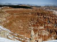
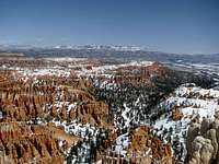
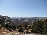
If I was prematurely infused with adrenaline on Monday, the following Tuesday would see Vegas finally catch up to me. Physically exhausted, I was dismayed to find Bryce Canyon covered in snow. I drove out to Rainbow Point and stopped at the overlooks on the way back. Even the simple walks to the overlooks seemed to sap my entire body of energy, and, with a cold wind blowing, I ruled out snapping on the snowshoes for longer hikes down into the canyon. Somewhere around Bryce Point I found myself unable to keep my eyes open. Springsteen playing on my IPod, I pulled into a parking lot and took a half hour nap.
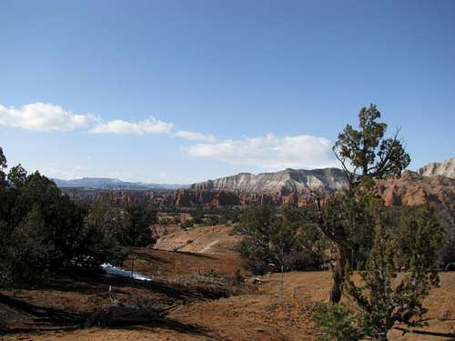
Then, it was back on the road. I came back to life as I followed Utah 12 down into lower elevations. Just ten minutes east of Bryce, and already there were no signs of tourists. I had arrived in the Utah outback. Various tablelands and mesas rose and fell before me, the only constant being the jutting promontory of the Aquarius Plateau in the distance. A sign for Kodachrome Basin State Park. Having heard of this place somehow, somewhere before, I made a rare spontaneous decision to take a peek. I was not disappointed.
Whereas Bryce Canyon, 30 miles away, was a vast amphitheatre, Kodachrome Basin was like a nice, cozy studio. The badlands and rock features felt more intimate, and the colors seemed brighter and more varied. I spent some time taking pictures along the short nature trail and checked out a short hike to Shakespeare Arch as well.
|
|
|
|
|
|
|
|
|
|
![Kodachrome Basin]() Shakespeare Arch Shakespeare Arch |
|
Further down the road. The canyons and mesas were becoming commonplace now, if no less spectacular. Aquarius/Bouldertop still loomed on the horizon. Past the town of Escalante I saw on the opposite horizon the remote Kaiparowits Plateau, and mentally made a note to mark it for future exploration.
![UT-12]() UT 12 UT 12 |
![UT-12]() UT 12 UT 12 |
![UT-12]() UT 12 UT 12 |
![Boulder Mtn/Aquarius Plateau]() Boulder Mtn Boulder Mtn |
![UT-12]() UT 12 UT 12 |
![UT-12]() Kaiparowits Kaiparowits |
As it descended into a veritable maze of tan, rounded canyons I realized that Utah 12 was truly unrivaled by any road I had previously driven. One wonder followed another, and I found myself unable to resist stopping at every corner of the road to attempt to capture it all on camera.
![UT-12]() UT 12 UT 12 |
![UT-12]() UT 12 UT 12 |
![UT-12]() UT 12 UT 12 |
![UT-12]() UT 12 UT 12 |
Onto the gangplank, then the sharp descent into the town of Boulder. Nestled at the base of the Boulder Plateau, it was every bit as beautiful and inaccessible as advertised.
![UT-12]() Boulder, UT Boulder, UT |
The road then climbed up along the edge of the Plateau, the highest in North America (barely beating out Grand Mesa in Colorado by a foot at Bluebell Knoll). Again the sunset worked wonders, as I gazed down below at the red knobs of Capitol Reef, my destination for tomorrow, as a storm dramatically blocked the Henry Mountains from view.
![UT-12]() From Boulder Mtn From Boulder Mtn |
![UT-12]() From Boulder Mtn From Boulder Mtn |
![UT-12]() Cap Reef from Boulder Mtn Cap Reef from Boulder Mtn |
![UT-12]() Cap Reef from Boulder Mtn Cap Reef from Boulder Mtn |
![Boulder Mtn from Torrey]() Boulder Mtn from Torrey Boulder Mtn from Torrey |
My day ended at the town of Torrey, nestled between Boulder Mtn and Thousand Lakes Mountain, another giant 11000 ft+ plateau. As I watched the sun disappear on the other side of Boulder Top all thoughts of Vegas faded from my immediate memory. This was heaven of a different kind. I felt pure bliss and simple, unadorned contentment. I could stay here forever.
Day 3 - Reefer Madness
Wednesday: the best hump day of my life. My first stop in Capitol Reef was Cassidy Arch. The park roads are nice, but the real essence of the place was still hidden and unseen. To transcend the ordinary in this park you must
ascend; take a trail, climb a few hundred feet or so, and a whole different world, a maze of high knobs, buttes, and suspended terraces, will peer out above the immediate cliffs to reveal itself to you, a rich, fulfilling scenery fragrant with color and content. I glimpsed the arch in the distance. A gulf of air separate it and me. The trail swerved right, along the cliffs, and made a U shape, swinging back left and taking me to a unique and precarious view of the arch.
![Cassidy Arch]() Cassidy Arch Cassidy Arch |
![Cassidy Arch]() Cassidy Arch Cassidy Arch |
![Cassidy Arch]() Cassidy Arch Cassidy Arch |
Then, I turned back, arriving at the junction with what is actually the terminus of the Frying Pan Trail. I had already gained the elevation, why lose it and have to regain it again when I was already here? I turned and followed it up with the specific goal of catching the view of the other side of the ridge. The trail was in no hurry though; after gaining gently a hundred feet or so it settled down in a wooded area of small and stunted trees. Ahead was a higher ridge, maybe, and the promise of a glimpse of the other side, or so I hoped.
Those hopes were realized. The place snuck up on me, a small high point on the mesa, and suddenly, a 360 degree view of breathless proportions.
It seems corny to write it now, but at that moment the entire desert, the entire landscape, seemed to stand still just for me. With such a vista I felt like the completely insignificant speck of a person that I was, and through that, I felt as if I was part and parcel of the land and landscape.
Still reeling from this natural high I descended down into the Grand Wash and followed it to the midway point, past the narrows, before turning back.
![Grand Wash]() Grand Wash Grand Wash |
![Grand Wash]() Grand Wash Grand Wash |
![Egyptian Temple]() Egyptian Temple Egyptian Temple |
Spring was the perfect season to visit Capitol Reef. I decided, as I drove east along the main road and the lush pastures surrounding the Fremont River, that this was by far my favorite National Park, one of my favorite places of all time.
|
|
|
![Hickman Bridge]() Hickman Bridge Hickman Bridge |
![Hickman Bridge]() Hickman Bridge Hickman Bridge |
|
|
|
Another hike, this time to the Hickman Natural Bridge. Again, the wonders of the park revealed themselves only after a little bit of elevation gain.
![Freaky Petroglyphs]() Freaky Petroglyphs Freaky Petroglyphs |
After heading back to some of the western overlooks I ended the day hiking the Grand Wash from the other end of the trail, meeting up where I had turned back a few hours ago, thus completing the hike on two separate trips.
![Grand Wash]() Grand Wash Grand Wash |
![Grand Wash]() Grand Wash Grand Wash |
![Grand Wash]() Grand Wash Grand Wash |
![Grand Wash]() Grand Wash Grand Wash |
Hanksville was a ghost town. I gassed up and drove north towards I-70, blasting Lady Gaga and admiring the views of the Henry’s behind me. To my east, the intricate features of the San Rafael Swell seemed within grasp yet out of reach. The sun was setting behind them as I came full circle with the state of Utah.
Day 4 - A Cloudy Confluence
I woke up angry in Moab on Thursday morning. Housekeeping knocked on my door at 9:00 AM, shaking me out of a deep slumber. I would have been even angrier at Best Western if it weren’t for the fact that I was grudgingly thankful for the inadvertent wakeup call.
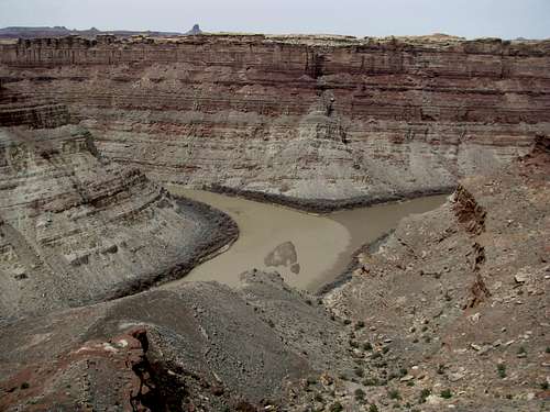
It was sunny in Moab, but the skies were a drab gray by the time I arrived at the Needles section of Canyonlands. The Confluence trail starts out descending a steep, schizophrenic canyon then climbs out.
From then on it traverses open, savannah like plateaus and slippery, confused rock faces five and a half miles. The destination: a rare viewpoint of the Confluence of the Green and Colorado Rivers. The scenery en route is hard to describe: hardly awe-inspiring, but curiously stimulating. In the distance the namesake Needles stood like a silent brigade of sentries, keeping an eye over the land they had been guarding the last thousand years.
|
|
|
![The Needles]() Needles Needles |
![Confluence Trail]() Needles Needles |
|
|
|
|
|
|
|
|
|
|
|
|
|
|
![Cyclone Canyon]() Cyclone Canyon Cyclone Canyon |
|
|
|
|
The Confluence itself was rugged, wild, and primieval. The muddy waters below seemed to juxtapose appropriately with the grey skies above, and immersed as I was then in the landscape, I could hardly imagine how it would look like on a clear, sunny day, nor would I have preferred that, either. Across the river from me was the Maze: one of the most remote areas in the lower 48, seemingly so close.
Day 5 - Snow White and the Seven Arches
My plan was Arches for my last day in Utah, a day to relax in an almost urban-ish park before returning to Boston. There was some light rain showers in the forecast, possibly snow. I should have been worried, but…come on, it’s Arches! How bad could it possibly get?
I had visited the park three years ago and returned in order to tackle two trails I had neglected then: Devils Garden and Delicate Arch. Devils Garden was up first, and I wanted to tackle every mile of every side trail to see every arch in this loop.
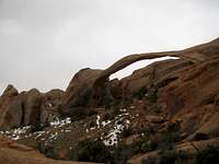
![Landscape Arch]() Landscape Arch Landscape Arch |
The weather held up until Landscape Arch, when it started to drizzle.
![Devils Garden Trail]() Before the storm Before the storm |
![Devils Garden Trail]() Before the storm Before the storm |
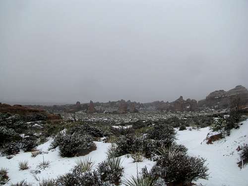
By the time I reached Partition Arch it was full on snow. By the time I reached Double O Arch it was a full on blizzard, a decent wind, and very limited visibility.
![The storm through Navajo Arch]() Navajo Navajo |
![Double O Arch in a blizzard]() Double O Double O |
![Dark Angel in white snow]() Dark Angel Dark Angel |
Shockingly to me, the route finding had been pretty difficult up to this point, involving some very dicey traverses down the slippery smooth sandstone ledges, made much worse by the weather. As I trooped on to the end of the trail at Dark Angel, I thought about returning the way I came, but ultimately decided on taking the “primitive” loop option.
The storm wound down by the time I reached Private Arch, and now it was melting fast. Even before the snow had stopped completely, what normally was the trail became a flooded wash of fast flowing water. I was already miserable; though I wore a goretex jacket, I had also donned work slacks, and my legs were freezing wet. Then came the kicker: the snowmelt formed giant, circular pools along certain lower parts of the sandstone trail. I had been able to circumnavigate some of them, but here was an impassable one. With steep, smooth, wet sandstone walls on both sides, I had no choice but to wade thigh deep through the pond. This obviously added to the discomfort of my legs, and I gasped as I felt the freezing water bursting into my waterproof boots, soaking every inch of my socks and feet.
|
|
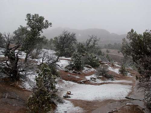
![Devils Garden Trail]() After the storm After the storm |
![After the snow]() After the storm After the storm |
I didn't even bother with dumping the water out, finishing the "primitive" loop and rushing back to the trailhead as fast as I could, water sloshing with every step. I changed into my snowpants back at the parking lot (changed socks as well), but it really didn't matter at this point, since the rain and snow were long gone.
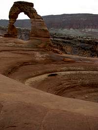
The final hike up to Delicate Arch was uneventful and provided me with the scripted ending to a great week.
Despite the distinct lack of summits bagged I had spent five days hiking over fifty miles in five national parks. The bachelor party seemed ages ago, and home was still a long way down the horizon.
The sun was out by the time I drove out of Arches and back towards I-70. I felt strangely level-headed: not too sad to be leaving Utah, not too eager to be going home. Maybe I was getting a little tired and needed a change of scene. Maybe the last day's weather had torn me down from initial highs of the week, trying to show me that Utah wasn't all just happiness and care bears and strawberries. But maybe, just maybe, I was secure in leaving because I was confident that I would return again, because one day I might even call this place home, because I knew now definitively that five days in Utah is barely time enough. Five lifetimes wouldn't be.
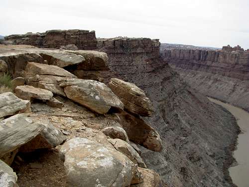
![Kolob Canyons]() To be continued? To be continued? |


Comments
Post a Comment