La montagna chiama i suoi figli, ed essi rispondono fedelmente al suo appello…
Osvaldo Cardellina, Diario alpinistico, 1964-65
Page texts: @ OsvaldoCardellina"Osva", passed away on May 2, 2022. Page owners: Christian Cardellina e Osvaldo Cardellina. Any updates from September 12, 2022: Antonio Giani, page administrator, friend and climbing companion.
Testi della pagina: @ OsvaldoCardellina "Osva", scomparso il 2 maggio 2022. Proprietari pagina:Christian Cardellina e Osvaldo Cardellina. Eventuali aggiornamenti dal 12 settembre 2022: Antonio Giani, amministratore della pagina, amico e compagno di salite.
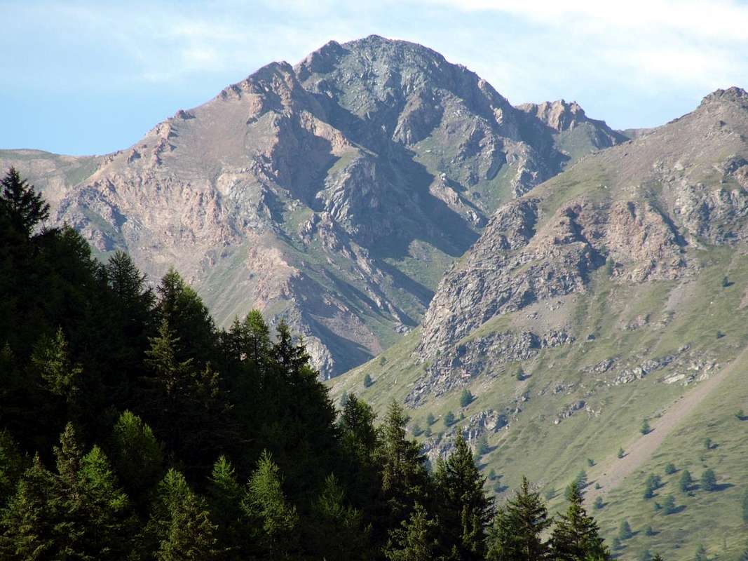
Tsa Sètse/Arpisson Overview Southern
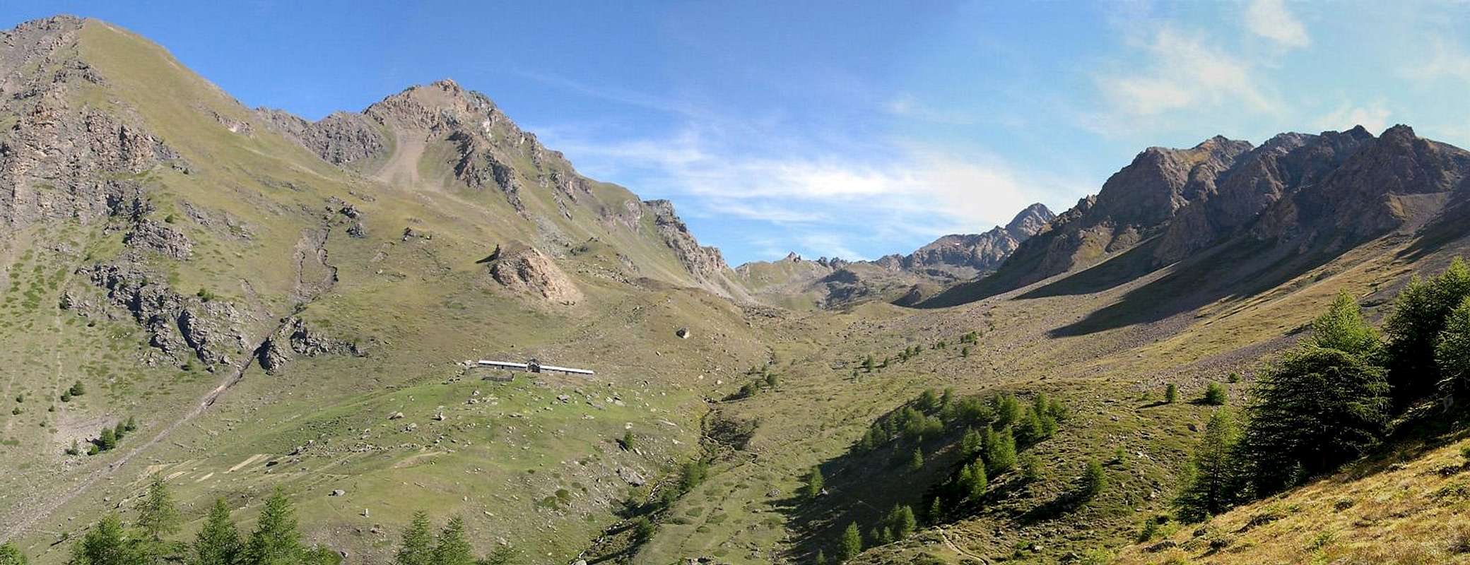
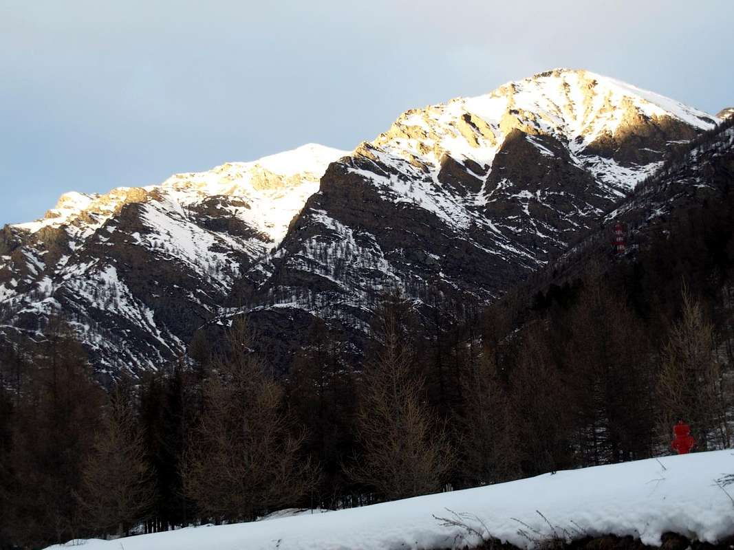
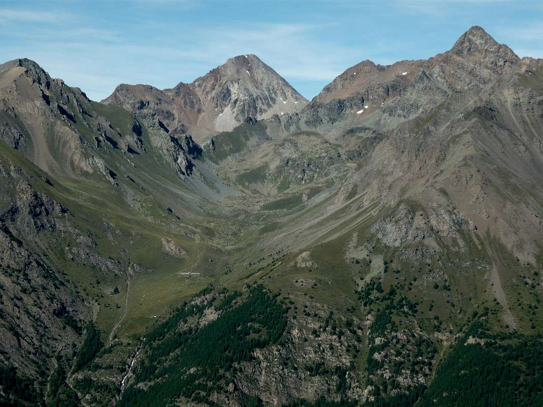
Starting from the Northwest, the entrance of the Valley, and continuing clockwise, after the appendices on the watershed Punta de la Pierre/Pointe du Drinc/Pointe du Couiss or more semply "Il Couiss" (The Blizzard)/Pointe de Monpers/Pointe de Chaz Sèche/Punta Valletta (3.090m) (see Pila Basin), we find the first great valley above the old Village Gimillan. This opens up, like a large canopy tree, sending a first branch in the Northwest into the valley below Arpisson which in turn "gives birth" a smaller one on its edges towards the East Hill of Tsa Sètze (2.815m). The main branch or North up towards the Pian di Bessey, Franco Nebbia Bivouac, Lake Garin and namesake hill below the pyramid Pic Garin (3.451m) forming the Vallon of Arpisson, unique in Aosta facing the South while others decline to the East (Grande Roise/Salé Chain towards St. Marcel Valley), West (Mount Emilius Group above Pollein Municipality) or to the North (Arpy's Basin and Valpelline). This area offers climbing, hiking, walking and two equipped routes. The third branch opens more towards forming the Northeast Vallon of Grauson. To find the third or Vallon Southern Arpisson they should, leaving the Central Valley of Dora Baltea, back in Cogne Valley: above the Hamlet of Gimillan or Dzimillan (1.785m) open two large vallons. The first, more to the East, goes up with the name of Grauson opening at the top, in the form of large leaf, towards the three branches of Doreire-Tessonet (East) and Lussert the opposite with its four and homonyms lakes (Low, Middle, High and Upper) under the immediately overhanging wide Col des Laures (3.035m). The second, to the West, is to Arpisson, which in turn splits "giving birth" even in the West Vallon of the secondary Tsa Setze or Tsa Sètse also Chaz Sèche (possibility of crossing towards Pila-Resort), above the Hamlet of Epinel. These two are among the congealed Buttress South-southwest of Punta Garin East and Tips Tsavanis and Vadaille or Vedaille West. The head of the valley is closed by the watershed, this time from the Southwest to the Northeast, divides the Valley of Cogne from Vallone Arbolle (Charvensod) and by Basin Pila (Gressan and Charvensod Commons). It stretches from Tsa Setze Hill forming the district of Punta Valletta (3.090m), Punta Pian Bessey (3.081 m) towards the Col Garin, immediately above the bivouac Franco Nebbia (2.740m), before rising to Mont Valaisan (3.307m) and still conclude with pyramidal Pic Garin (3.451m). On the opposite side, ie to the West of the Valley of Tsa Setze real, and starting from the tiny Val Lessert one another a series of small, wild valleys which first reach the Comba di Tomba to finally reach the Pointe Vadaille at the border with "Conca" (Basin) de la Pierre, just above Ozein Village in Aymavilles Municipality and nearby Pila Resort.
Partendo da Nordovest, all'ingresso della Valle, e continuando in senso orario,dopo le appendici sullo spartiacque Punta de la Pierre/Punta del Drinc/Punta del Couiss o più semplicemente "Il Couiss" (La Tormenta)/Pointe de Monpers/Pointe de Chaz Sèche/Punta della Valletta (3.090 m) (vedi Pila Basin), troviamo il primo grande vallone sopra il Villaggio di Gimillan. Questo s'apre, a guisa di grande chioma d'albero, inviando un primo ramo a Nordovest verso il Vallone di Arpisson che, a sua volta ne "partorisce" uno più piccolo ai suoi margini Orientali verso il Colle di Tsa Sètze (2.815 m). Il ramo principale o Settentrionale sale verso il Pian di Bessey, Bivacco Franco Nebbia, Lago Garin ed omonimo Colle al di sotto della piramide del Pic Garin (3.451 m), formando il Vallone d'Arpisson, unico in Valle d'Aosta rivolto verso Mezzogiorno poiché i restanti nonché omonimi declinano ad Oriente (Sottogruppo Grande Roise/Becca di Salé in direzione della Valle di St. Marcel), Occidente (Monte Emilius al di sopra di Pollein) oppure verso Settentrione (Conca d'Arpy e Valpelline). Quest'area offre ascensioni, escursioni, passeggiate e due vie attrezzate. Il terzo ramo s'apre maggiormente verso Nordest costituendo quello del vicino Grauson. Per trovare il terzo o Vallone Meridionale di Arpisson si deve, abbandonando la Valle Centrale della Dora Baltea, risalire l'intera Valle di Cogne: sopra la Frazione di Gimillan o Dzimillan (1.785 m) esistono due grandi valloni. Il primo, più ad Oriente, sale con il nome di Grauson aprendosi in alto, a guisa di grande foglia, verso i tre rami di Doreire-Tessonet (Oriente) e Lussert (Occidente), coi suoi quattro laghi subito sottostanti al largheggiante Col des Laures (3.035 m), collocato al confine col Vallone des Laures (Grand Brissogne). Il secondo, verso Occidente, costituisce quello di Arpisson, che a sua volta si sdoppia "partorendo" ancora più ad Ovest il secondario Valloncello di Tsa Setze, sopra la Frazione di Epinel (dal colle omonimo traversata a Pila). Questi due sono rappresi tra il Contrafforte Sud-sudovest della Punta Garin ad Est e dalle Punte di Tsavanis e Vadaille o Vedaille ad Ovest; la testata della vallata é chiusa dallo spartiacque che, questa volta da Sudovest a Nordest, divide la Valle di Cogne dal Vallone di Arbolle (Charvensod) dalla Conca di Pila (Comuni di Charvensod e Gressan). Esso si distende dal Colle Tsa Setze (2.815 m) formando il circondario Punta della Valletta (3.090 m) e Punta di Pian Bessey (3.081 m) fino al Col Garin (2.815 m), appena al di sopra del Bivacco Nebbia (2.740 m), per poi risalire al Mont Valaisan (3.307 m) e terminare con il Pic Garin (3.451 m). Dalla parte opposta, cioé ad Occidente del Vallone di Tsa Setze vero e proprio, ed iniziando dalla minuscola Val Lessert si succedono una serie di piccoli e selvaggi valloni che raggiungono dapprima la Comba di Tomba per infine raggiungere la Pointe Vadaille al confine con la Conca de la Pierre, giusto al di sopra di Ozein nel Comune d'Aymavilles.
Getting There
BY CAR:
From TORINO, MILANO, etc: Motorway A5. Exit at IVREA or Quincinetto (PIEDMONT) AOSTA West/Aymavilles, Cogne Municipalities.
From Aymavilles(646m) towards Cogne Valley: Vieyes (1.132m), Epinel(1.437m)Crétaz(1.494m) Villages, through Regional Road. To Cogne(1.534m), always through Main Road. After in North towards Montroz/Gimillan Villages(1.681m, 1.785m); this last in North-northwest to Franco Nebbia Bivouac (2.740m), with various paths in Arpisson Vallon. All the three last through Regional Roads from Cogne Municipality.
From FRANCE: through the Mont Blanc Tunnel to Entrèves-crossroads to Vény/Ferret Valleys - Mountain Guides of Courmayeur - La Saxe Rock Gym - Courmayeur. By Little Saint Bernard Hill, closed since November until half May to La Thuile Valley - Pré Saint Didier - Courmayeur. It is not necessary to take Motorway A5: you can drive on SS.26, in the direction of AOSTA - IVREA - TURIN.
BY PLANE:
Aeroporto "Corrado Gex" Saint Christophe (Aosta).
Walks Hikes Ascents
1) - Epinel Hamlet, Tavaillon, Pian de Seutse Alps (1.436m, 2.013m, 2.198m): Excursion with path in Northwest to Drinc Hill (2.565m), near Arno Bivouac (EE/F; 3h'00).
2) - Col Tsa Sètze (2.815m): Excursion from Gimillian with path in Northwest before to Arpisson Alp, after in a vallon under P. di Pian Bessey/P. della Valletta (E/F; 3h'00).
3) - Col Tsa Sètze - P. de la Pierre Traverse (2.653m): Excursion by hill on crest (Piatta Grevon-P. Monpers-P. Couìss-P. Drinc) equipped "Via Panorama" (EE/F; 2h'15).
4) -Col Tsa Sètze - P. della Valletta (3.090m): Climbing from hill on Southwest Ridge; since 2003 currently equipped route "Via Ferrata" (EE/A/F+; 1h'15/1h'30).
5) - Bivouac Franco Nebbia (2.740m), Col Garin (2.815m), Lake (2.854m): Excursion Gimillian with path Northwest towards Arpisson Alp, Pian Bessey (E/F; 3h'30).
6) - Nebbia Bivouac, Lake, Mont Valaisan (3.307m), Pic Garin (3.451m): Climbing by various routes, better Norhwest Crest and North Edge (A/F+/PD-; 3h'15/3h'45).
A bit of Toponimy towards Arpisson & Tsa Setze
But what does Arpisson?It sounds simple because the radical Arp is easy to assimilate at Arps, Alps, Alpage, Alpen and so on and so forth. And that suffix "Isson"? Attributable to something larger or which is located in the highest part, type Damon or di Sopra (Upper). From here are the derivations Arpy, Arsy, Ars, Arnouva or Arp Nouva, Lardamon or Arp Damon and Lardamoun ie The Arp Damont. So Arpisson wants to mean a large vallon above. But all the valleys we have above them something and then something does not. Regardless that the Alps are differentiated Le Tramouail, Tramail or Trémail and Tremaille for the intermediate pasture, while the highest, that is the last, is called the La Tsa the word Arpisson may have a different origin and farther then that has been adapted to as I said above. The good Umberto Pelazza in his book "Who knows why they call it so as a walk in the vocabulary of the mountains of Aosta Valley", published by the C.A.I. Aosta in 2011, that the name comes at the root ALP ie "high pasture", this as a result of a migration of peoples Uralo-Altaitici of 3000 BC. In Hungary-Ugric linguistic family anoint this population, coming from Central Asia via Turkey and the Balkans to the North beyond the Engadine Alps and enters in the territories of the Ligurian; these emigrated in France and in Spain (specifically in the Basque Country). It all seems resolved but it is not so, because on page 109, about the Mont Ormelune, speaks of the root OR as a variant of Ar, Arp who along with MEL, ie elevation, then gave "the pasture of the rocks". This mountain is also called Archeboc but could also told Artsabouc scilicet Ar, Tsa and Bouc tying together three words in Alpine style. Others indicate Artse or wooded area but also from Latin Arcta, viz an area with narrow and difficult passage. But still on page 58 Arpisson is connected to Pissevache and Pisonet where to peson, pison and pisonet indicates a stream with small waterfalls see Sorapiss in the Dolomites. The story is not over yet because the Cima d'Entrelor come into play OR and AUR, French variations of Ar and Arp as the underlying Orvieille which was originally Arvieille. In fact, even in the Vallon of Planavalle Pennine Alps we find a Tramail des Ors, while in the adjoining Vertosan just after Col Felita or Fetita (from "feyes" ie sheep) are the Or dei Frà or the Pasture of the Friars. Finally for to conclude, with regard to the Colle dell'Arietta is not a hill quite breezy but Ayette ie small alp between the Valleys of Cogne and Val Soana, while the name Laures (Vallon, Lakes, Hill Punta, Mont) we have the radical Aur as variable of Ar, Arp. This little discussion choose what you like, so you can not please everyone ...
Ma cosa significa Arpisson? Sembra semplice poiché il radicale Arp é facile assimilarlo ad Alpe, Alpeggio, Alpage, Alpen e chi più ne ha più ne metta. E quel suffisso "isson"? Da ricondurre a qualcosa di più grande o che si trova nella parte più elevata, tipo Damon ovvero di Sopra. Da qui abbiamo le derivzioni di Arpy, Arsy, Ars, Arnouva o Arp Nouva, Lardamon o l'Arp Damon e Lardamoun cioé L'Arp Damont. Quindi Arpisson vuole significare un grande vallone soprastante. Ma tutti i valloni sono soprastanti a qualcosa ed allora qualcosa non torna. A prescindere che le Alpi vengono differenziate in Le Tramouail, Tramail o Trémail e Tremaille per quelle posizionate in un settore di pascolo intermedio, mentre quella più elevata, cioé l'ultima, vien chiamata La Tsa, la parola Arpisson potrebbe avere un'origine diversa e più lontana che successivamente é stata adattata a quanto detto sopra. Il bravo Umberto Pelazza nel suo libro "Chissà perché si chiama così a spasso nel vocabolario dei monti valdostani", edito dal C.A.I. di Aosta nel 2011, riconduce il toponimo alla radice ALP cioè "alto pascolo", questo a seguito di una migrazione di popoli Uralo-Altaitici del 3000 avanti Cristo. Di ceppo linguistico ungaro-finnico questa popolazione, arrivando dall'Asia Centrale attraverso la Turchia ed i Balcani, oltrepassa a Settentrione le Alpi Retiche ed entra nei territori dei Liguri; da questi emigra in Francia ed in Spagna (precisamente nei Paesi Baschi). Sembra tutto risolto ma non é così, perché a pagina 109, a proposito del Mont Ormelune, parla della radice OR come variante di Ar, Arp che insieme a MEL, cioè elevazione, davano quindi "l'Alpeggio delle rocce". Questo monte é chiamato anche Archeboc ma potrebbe anche detto Artsabouc cioè Ar, Tsa e Bouc legando insieme tre vocaboli prettamente di stile alpino. Altri invece indicano in Artse ovvero zona boschiva, ma anche dalla derivazione latina di Arcta, cioé una zona dal passaggio stretto nonché alquanto difficoltoso. Ma ancora a pagina 58 Arpisson viene collegato a Pissevache e Pisonet dove per peson, pison e pisonet s'indica un corso d'acqua con piccole cascate: vedi il Sorapiss in Dolomiti. La storia non é ancora finita perché per la Cima di Entrelor entrano in gioco OR e AUR, varianti francesi di Ar ed Arp come nella sottostante Orvieille che in origine era Arvieille. In effetti anche nel Vallone di Planavalle nelle Alpi Pennine riscontriamo un Tramail des Ors, mentre in quello adiacente di Vertosan subito dopo il Col Felita o Fetita (da "feyes" cioé pecore) troviamo l'Or dei Frà ovvero l'Alpe dei Frati. Infine e per concludere, per quanto concerne il Colle dell'Arietta non si tratta di un passo alquanto ventilato bensì Ayette ossia piccola alpe tra la Valle di Cogne e la Val Soana, mentre per il toponimo Laures (Vallone, tre Laghi, Colle, Mont e Punta) abbiamo il radicale Aur come variabile di Ar ed Arp. Di questa piccola disamina scegliete ciò che preferite ...
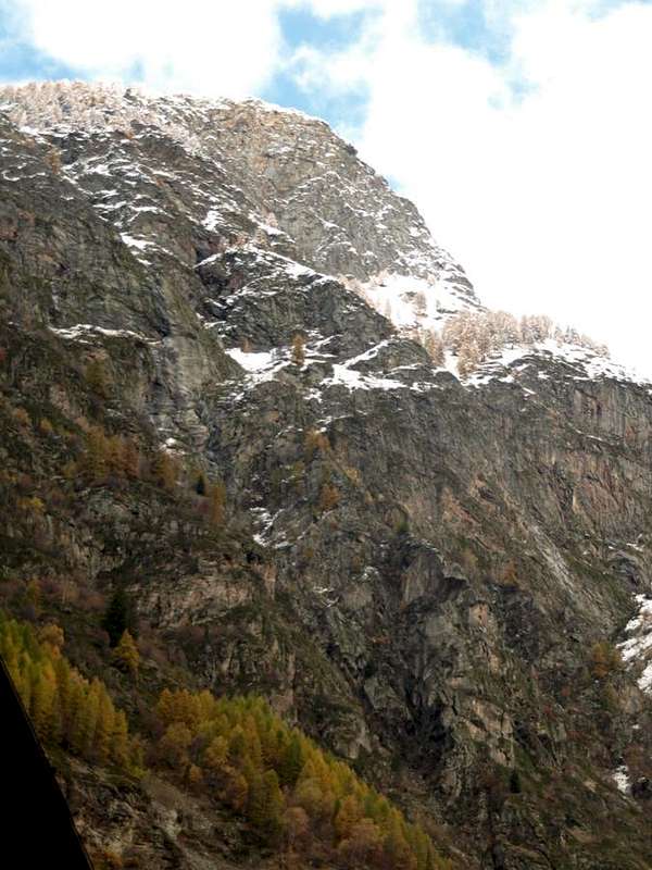
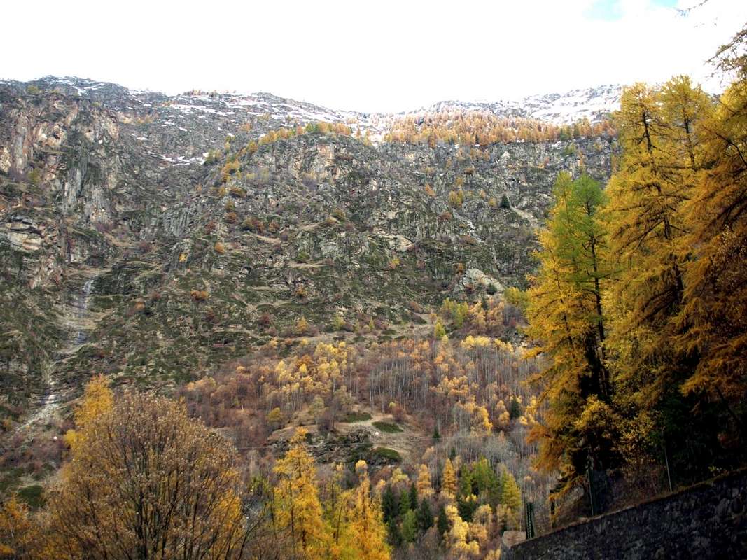
How many ways are there to go from the wide Pila Basin to Cogne Resort and vice versa? About seven. These are the routes that connect these two places through the Valley of Dora Baltea with that of Torrent Grand'Eyvia and then to that of "tying" the City of Aosta with Cogne Commune. A journey that is lost in the mists of time and made by various procedures and steps quite diversified, especially given the point of departure or the arrival date. There at that place, over the long ridge from Punta de la Pierre, known by all as "La Pera" (2.653m), at the West and above Ozein of Aymavilles reachs Col Tsa Setze or Chaz Sèche (2.815m), there is the Valley Cogne and the Gran Paradiso. In ancient times it was the "Iseran", namely the large area of mountains that were heading for the valleys of Orco and Isère. Then the watershed gets up to one "Spallone" (Great Shoulder) reaching the Tip of Valletta (3.007m, 3.090m), the culmination of this tiny subgroup that ends at Colle Garin, once called "Bassa di Garin" (Low Garin, always 2.815m) before heading to the Group of Mount Emilius. I never knew, despite the researchs done, nothing more than about the name Garin, while Tsa Setze means alp very high, perhaps the last and certainly lack of waters, ie dry. Most likely in the old days, when it was also exploited the last blade of grass, there had to be on the Northern Slope over the Plan de l'Eyve or Eyvie (more water into the tableland) or on the Southern or Arpisson the last pastures, real outposts before reaching the Col Tsa Sétze. In fact, while on the side of Pila Basin are still a trace of the rushing water from under the hill that joins the tiny emissary from a pond (2.525m) at the Western foot of Mont Belleface Punta Valletta (2.970m, 3.090m) forming the Torrent de Plan de l'Eyvie, on the opposite side of Cogne we find nothing. Only two gutters or Torrent de Chasèche and parallel Torrent de Piscicail run through, but from under the Tip Tsavanis and above Epinel, this South side; then to track the water must go down in the center of the more large Vallon of Arpisson, where, at the Plan Bessey, the junction 2.525 meters for Col Garin find a spring gushing from a rock. Or down at the Torrent Arpisson nearby homonymous pasture. Here reappears the name Tsa Sètze becoming Chasèche, which then determines that of the hill above the apex of this small and desolate valley.
Quanti modi ci sono per andare da Pila a Cogne e viceversa? Sono all'incirca sette. Questi sono gli itinerari che collegano queste due località passando dalla Valle della Dora Baltea a quella della Grand'Eyvia e quindi "legando" la Città di Aosta al Comprensorio di Cogne. Un viaggio che si perde nella notte dei tempi e compiuto tramite diverse modalità e passaggi alquanto diversificati, soprattutto in considerazione del punto di partenza o di quello di arrivo. Là, oltre quella lunga cresta che dalla Punta de la Pierre, conosciuta da tutti come "La Pera" (2.653m), all'estremità Occidentale e sopra il Villaggetto d'Ozein di Aymavilles raggiunge il Colle Tsa Sètze o Chaz Sèche (2.815 m), esistono la Valle di Cogne ed il Gran Paradiso. Nei tempi antichi miticamente era considerato il lontano "Iseran", ovvero quella grande area di montagne che declinavano verso le Valli dell'Orco e d'Isère in Francia. Poi lo spartiacque si rialza ad uno Spallone raggiungendo la Punta della Valletta (3.007 m, 3.090 m), il culmine di questo minuscolo sottogruppo che si conclude al Colle Garin, una volta chiamata "Bassa di Garin" (sempre 2.815 m) prima di dirigersi verso il Gruppo dell'Emilius. Non ho mai saputo, nonostante le ricerche effettuate, nulla di più del toponimo Garin, mentre Tsa Sètze stà a significare un'alpe molto alta e forse l'ultima e certamente scarsa e povera in acque, cioé piuttosto secca e forse pur arida. Molto probabilmente nei tempi andati, quando veniva sfruttato sin l'ultimo fil d'erba, dovevano esistere sia sul Versante Settentrionale sopra il Plan de l'Eyve od Eyvie (sempre dell'acqua) oppure sul Meridionale o d'Arpisson degli ultimi alpeggi, veri avamposti prima di raggiungere il Col Tsa Sètze. In effetti mentre sul lato Pila troviamo ancora una traccia dello scorrer dell'acque da sotto il colle che si unisce al minuscolo emissario proveniente da uno stagno (2.525 m) alle pendici Occidentali di Mont Bellefaçe e Punta Valletta(2.970 m, 3.090 m) formando il Torrent de Plan de l'Eyvie, su quello opposto o di Cogne non troviamo nulla. Solo due rigagnoli o Torrent de Chaseche e Torrent de Piscicail percorrono, ma da sotto la Punta Tsavanis e sopra Epinel, questo versante Meridionale; quindi per rintracciare l'acqua bisogna scendere nel centro del Vallone d'Arpisson, dove, presso il Plan Bessey, al bivio pel Col Garin ritroviamo una sorgente sgorgante da un masso (2.525m). Oppure scendendo al Torrent di Arpisson nelle vicinanze dell'omonima alpe. E qui riappare il toponimo Tsa Sètze trasformato in Chaseche, che poi determina quello del soprastante colle all'apice di questo valloncello desolato.
And for the inhabitants of Cogne? Much the same thing. But that ridge forced their to a long tour Aymavilles to gain access to the Dora Valley and Augusta. Where he spent the ancient "Via delle Alpi" connecting Amsterdam to Venices and bypassing the Colli dell'Arietta, Scaletta (Small Ladder) and Acque Rosse with a large business that tied all of Europe down through the entire Valley of Cogne reaching Aymavilles and Villeneuve and then cross the Gran San Bernardo, after scoring four in the European Fairs in Thora or Thouraz, destroyed by a huge landslide at dawn on 6 July 1564. Moreover with half on "Salassian Route" towards Gignod and then with the Via Francigena passing through Gignod, Etroubles, St. Oyen and St. Rhémy always towards the Great in the directive that linked Canterbury to Rome. So the "Cogneins" were accustomed to these transits linking the ancient Conia also with transporting ore by the Romans to the Piedmont and the passage of all these "intruders" towards the Valley of the Dora Baltea. But when they decided to go to St. Marcel, Brissogne, Charvensod, Gressan and Jovençan the speech was different; preferred, the most experienced and knowledgeable of the area, climb the ridges passing in high hills. By that of St. Marcel in the East than the Drink to the West; so for the Pila Basin, which then existed only with ups and seeds isolated pastures. In fact we not find passing notes until 1870, when Monsieur P.-L. Guignard in "Echo des Alpes" in 1877 with the title "Corespondance", pages 71/2 said that to travel from Aosta to Cogne it is passed from a hill at the Tip of the Valletta (3.090m). A report so chaotic that demonstrates how confused, but did not find guides and information on the spot, as the route between the two major centers was not as widely known by everyone. The unusual move from Charvensod Hamlet towards Cogne Common was through "un col 9,000 pieds, dont je ne pus savoir le nom et gravis la cime la plus rapprochée qui, d'après le barométre accusait 9,900 p. environ ...". Surely the Hill of the Valletta (3.000 meters), with a choice of itinerary so reckless as tiring ignoring neighbors Hills "Bassa de Garin" Tsa Sètze (both 2.815m) but for him misleading, since the first addressed by Arbolle Eastward and according by Chamolé toward South-southwest. But the ideas were very clear to the villagers, who passed for the same always, also with the their cattle. A serie of transits usual to cross by one valley to another, moving the same or simply to get to a TSA or a hill to graze the herd.
E per gli abitanti di Cogne? Più o men lo stesso. Quella cresta costringeva ad un lungo giro fino ad Aymavilles per poter accedere alla Valle della Dora ed Augusta. Dove passava l'antica "Via delle Alpi" collegando Amsterdam alle Venezie e scavalcando i Colli dell'Arietta, Scaletta ed Acque Rosse con un grande commercio che legava tutta l'Europa scendendo l'intera Valle di Cogne sino ad Aymavilles e Villeneuve per poi attraversare il Gran San Bernardo, dopo aver realizzato quattro Fiere Europee a Thora o Thouraz, distrutta da enorme frana all'alba del 6 Luglio 1564. Oppure per metà sulla Via dei Salassi fino a Gignod e quindi con quella Francigena transitando per Gignod, Etroubles, St. Oyen e St. Rhémy in direzione sempre del Grande nella direttiva che univa Canterbury a Roma. Quindi i "Cogneins" erano abituati a questi transiti che collegavano anche Conia col trasporto del minerale da parte dei Romani verso il Piemonte ed al passaggio di tutti questi "intrusi" verso la Valle della Dora Baltea. Ma quando decidevano di andare a St. Marcel, Brissogne, Charvensod, Gressan e Jovençan il discorso era ben diverso; preferivano, valligiani i più esperti e conoscitori del territorio, scavalcare le creste passando in alto sui colli. Da quello di St. Marcel ad Oriente a quello del Drink a Ponente; così anche per Conca di Pila, che allora non esisteva se non con alti e semi isolati alpeggi. Infatti non troviamo note di passaggio fino al 1870, quando Monsieur P.-L. Guignard in "Echo des Alpes" 1877 col titolo "Corespondance", pagine 71/2 narra che per recarsi da Aosta a Cogne sia transitato da un colle presso la Punta della Valletta (3.090 m). Una relazione tanto caotica quanto confusa che dimostra, non avendo trovato guide ed informazioni in loco, come l'itinerario tra i due importanti centri non fosse così diffusamente da tutti conosciuto. L'inusuale passaggio da Charvensod a Cogne avveniva tramite: "un col 9,000 pieds, dont je ne pus savoir le nom et gravis la cime la plus rapprochée qui, d'après le barométre accusait 9,900 p. environ ...". Sicuramente il Colle della Valletta (3.000 metri circa), con scelta d'itinerario tanto scriteriata quanto faticosa ignorando i vicini Colli di Garin e di Tsa Sètze (entrambi 2.815 m) ma per lui ingannevoli, poiché il primo rivolto da Arbolle ad Est ed il secondo da Chamolé a Sud-sudovest. Ma le idee erano ben chiare ai valligiani, che passavano per i medesimi da sempre, anche col loro bestiame. Transito usuale per traversare da una valle all'altra spostando il medesimo o più semplicemente per arrivare ad una TSA od a un colle per pascolarne la mandria.
Mountain Condition
You can get weather forecasts at the official site of the Regione Valle d'Aosta:
Parents refers to a larger category under which an object falls. For example, theAconcagua mountain page has the 'Aconcagua Group' and the 'Seven Summits' asparents and is a parent itself to many routes, photos, and Trip Reports.


 2465 Hits
 79.04% Score
 10 Votes