
|
|
Route |
|---|---|
|
|
42.63006°N / 0.42918°E |
|
|
Mountaineering |
|
|
Spring |
|
|
One to two days |
|
|
Class 4 |
|
|
PD / II+ (UIAA) |
|
|
II |
|
|
Page optimized for a screen resolution of 1280 x 1024 pixels
Overview
This is not an usual route; more, it could be original or, at least, I have not found any reference about, in books nor the Internet. The Peak of Turets itself is a forgotten summit; a modest prominence that was left in the shade by the extrem proximity of a couple of threethousanders (10 minutes to go until Point South-east of Forqueta).Turets stands at the junction of three ridges: those that go to the needles of Forcau, Tuca of Llantia and peaks of Forqueta. Two of these ridges, sharp but relatively easy, along with the solitary and fascinating Valley of Forcau, are the main ingredients of this route. I have climbed Turets twice, by diferent routes, and I can say that is a surprising viewpoint on the south-western part of Massif of Posets and its ascent routes (at least those that I know) are beautiful and entertaining.
It is possible to reach the summit of the group of Forqueta from the Peak of Turets in less than half an hour. I think that it is more logical to directly descent by the eastern ridge when reaching Turets, without the “go and return” to Forqueta. However, as many people are irresistibly atracted by threethousanders, I have include the option of visiting Forqueta in the route description.
 On the summit, with a casual mate
Technical details:
* Elevation gain: Approximately 1,900 meters.
* Minimum / Maximum Height: 1,118 ms / 2,962 ms
* Time: about 8h30, altogether, not counting stops (start and end in Eriste).
* Difficulty: PD. More than one hour of narrow ridges with continuous little difficulties. Two short passages of II+, one of them exposed, are the maximum degree. Snow slopes up to 50º.
* Done for the last time: June 13, 2008.
Getting There
 Espigantosa waterfall
 Mount Escorvets
The usual way to get to Angel Orús Hut is from Espigantosa Bridge. To reach this place, you must take a narrow road to the left when leaving the village of Eriste (see the Peak of Forqueta page) by the north (there are signs indicating the hut at the intersection). After 2 km, it becomes a dirt road passable by cars, with a little care. After 3 km more, you will arrive at Pleta del Estallo, where there is a small space to park to the left. There are about 250 metres up the bridge, where you can also park, but the road is in such poor condition that it is better to go on foot, even having a 4x4.
The dirt road finishes in front of Espigantosa waterfall, as an esplanade at the end of wich you can see a little footbridge. When crossing it, you will find the trail that, through a true vegetal tunnel, goes up towards Pleta de Riberes, where you can arrive in less than an hour. This is a good place to do vibouac or camp.
To continue to Angel Orús Hut, you must follow the same trail, which now pass by a little dense forest that lets see the surrounding mountains (Escorvets, the two Tucas, Forcau ...). The hut is reached after a further three quarters of an hour (1h45 from the beginning). Leaving Eriste on foot, 3 hours and a quarter are needed to arrive at the refuge, by Tramarius bridge.
 Ángel Orús Hut
Route Description
The route: Refugio Ángel Orús - Valle del Forcau - arista sur del Turets - Pico de Turets - Arista del Forcau - collado 2.845 - Ibón de Llardaneta - Refugio Ángel Orús. Map taken from the digital sheet "POSETS" published by Editorial Alpina.
1.- The ascent: Valle del Forcau
Leave the Ángel Orús hut towards the mouth of the Valley of Forcau, visible from the back part of the building, beyond the weather station. Go up by a slope alternating grass and rocks. You can go by almost anywhere but time to time, a cairn helps to find the better path. Thus, you will arrive at a landing from where there is a beautiful view on the hut dominated by the mount Escorvets. Valley of Forcau from the hut back
 The hut from the first landing
Continue going upvalley, leaving far to the left a small anonymous lake. The cairns conduce first by the stones of the right side, at the foot of the Needles of Forcau, after by the axis of a wide gully of light inclination.
 Anonymous lake
 Valley of Forcau first landing
At the top of the gully, there is a second landing, next to a small rocky prominence. Follow ahead, turning gradually with the valley to the left (W) and losing some height to cross its axis and take ledge that raises diagonally by the southern slope. At this point, if the atmosphere in this solitary valley is impressive, the panorama to the back (SE) is beautiful, with the mountains of Vallibierna and Cerler in the horizon.
 Valley of Forcau medium section
 Valley of Forcau medium section (from the top)
After the curve of the valley, the Peak of Turets and the headwaters of the valley appear. From the bottom of the circus to the ridge, without snow, the better path is in the right side, towards the first breach under Turets. With snow, you can go up almost anywhere, by slopes that never exceed 50º. When I was, I go up directly by the axis of valley and circus, reaching the ridge near the point 2,902 (see the map), and I found the maximum inclination in the final meters with about 45º.
 Peak of Forqueta over Valley of Forcau
 Point 2,902 on top of the circus
When reaching the ridge, follow it to the right. The first part of this crest, until the breach previous to the summit pyramid of Turets, is an aerial and funny succession of granite blocks without significant difficulties (I).
 Ridge from point 2,902 to summit
 Point 2,902 from the top
That breach is narrow and limitated by vertical steps. To leave towards Turets, you have to climb a step of about 5 meters, not dificult (II+) but impressive by the surroundings. This is the more difficult rocky passage of the whole route. It can be surrounded by the left side but it would be more exposed. After the step, follow up the ridge, that is now more tended, using frequently the hands (I) until the summit. When reach it, Posets and Espadas, the highest summits of the massif, appears.
 The 5 ms step (UIAA - II+)
 View to the north: Espadas and Posets
The view fron the summit is beautiful in any direction, as you can see in this 360º interactive panoramic image. If not, below there are some photos of the prettiest views.
 View to the southwest: peaks of Eriste
 View to the northwest: Massif of Tres Sorores (Monte Perdido)
If you want to visit the Peak of Forqueta, follow the ridge to the Northwest until the Point SE of Forqueta, passing the intermediate col. The ridge between both peaks is wide, slightly steep and without dificulty. From there, go down by a ledge in the left side of the ridge, using sometimes the hands (I), mainly in the outset. This ledge leads until the lowest point between the two peaks of Forqueta, where there is to return to the ample ridges edge that leads to the Peak of Forqueta. From this summit you can go down by the Northeast ridge to the Col of Eriste and return to the Angel Orús hut by the normal route. But, if you want to cover also the East ridge of Turets, you need to return to it by the same path. You can go and return in about 45 minutes.
 View to the east: Pico Maldito and Aneto
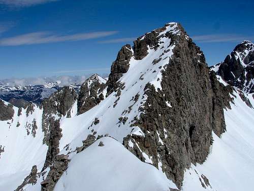 North ridge: Peaks of Forqueta
2.- The descent: Valle de Llardaneta
So, we continue the original route going down from the Peak of Turets by its eastern ridge. It begins ample but soon the ridge narrows in a horizontal section with the typical succession of blocks (I). East ridge from the summit
 East ridge medium (horizontal) section
Soon, the first gendarme (or turet) appears. You can climb it by the right side, by some fissures more exposed than difficult (II). After a breach, the second one is slightly most complicated, with a 4 meters slab, short but very exposed and smooth surfaced (II+). After that, there is a shoulder when the ridge returns to be ample and goes down until a col 2,845, previous to a needle.
 East ridge from the shoulder
 Col 2,845 from the shoulder
Go down by the left side of the ridge, of moderate slope until the col. There you can go down to the right and return to the Valley of Forcau. But, to change the views, it is better go to the left to descend towards the Valley of Llardaneta and its lake. The slope begins in 45º but soon it attenuates and it finishes quite softly (in both photos below, my footprints can be seen).
 East ridge from the pass 2,845
 Summit and east ridge from Llardaneta
Follow the Valley of Llardaneta down and surround the lake (in the photos, a flatter extension in the continuous snow surface) by anyone of its banks (or to cross it if it is frozen) until the footpath that comes from Col of Eriste (or the wide river of prints when there is snow).
 Valley of Llardaneta
 Turets and Forquetas from Lake of Llardaneta
When reaching the northeast border of the lake, where it is its water-drainage, follow the footpath (or prints) through a narrow ravine. This trail is very clearly signed with cairns, paintings and even signs, as a part of GR11, a very popular path through the Pyrenees. It will lead you quietly until the Ángel Orús Hut.
 In the ravine of Llaradaneta
 Valley of Eriste
Essential Gear
Not technical equipment required. A rando rope and some flat tape can be useful in the two II+ passages if some member of the partie has vertigo or little skill in climbing. But in these cases, I advice to take the normal path, much easier than.Carry the adecuate clothes and individual elements (sticks if you want, piolet & crampons in winter, etc.) for high mountain hiking in temperate areas.
External Links
If you don't understand completely the text on this page or you want to practice another languages or simply you are a little eager, you can find the original issue in Spanish in the website Pirineos3000.com(La versión original en español de esta página se encuentra en Pirineos3000.com)