
|
|
Mountain/Rock |
|---|---|
|
|
42.81667°N / 19.21989°E |
|
|
6680 ft / 2036 m |
|
|
Overview
 Veliki Žurim (2036 m) and Mali Žurim (1962 m) from Bare Bojovića (1540 m)
MORAČKE PLANINE range is placed in the central part of Montenegro. This mountain range is structured from few beautiful and impressive mountains as are Kapa Moračka, Lola, Stožac, Tali, Lukanje Čelo, Štit and Žurim. This mountain area is also enriched with two beautifully lakes - Kapetanovo Jezero and Manito Jezero.
But, when you appraoching Moračke Planine and Žurimi peaks from Nikšić town, entering in Bare Bojovića plateau, you can see Žurimi peaks surrounded by breathtaking wide grassy vasty plateau. That scenery is for sure one of the most beautiful mountain landscape in Montenegro.
Žurimi is the name of two peaks - Veliki Žurim (Big Žurim, 2036 m) and Mali Žurim (Small Žurim, 1962 m). Žurimi peaks are placed on the southeast from DURMITOR mountain range. Those two peaks are naturally connected by pass from where is possible to reach the summits of both peaks.
The summit of Žurimi offer incredible northwest view to DURMITOR and its highest peak Bobotov Kuk, but first of all you can enjoy in the beauty of many other peaks of Moračke Planine in the neighbourhood of Žurimi.
Route Info
 Map of Žurimi area
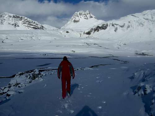 Winter approach to Žurimi
ŽURIMI
Veliki Žurim, 2036 m
Coordinates: 42.816667 N , 19.219889 E
Mali Žurim, 1962 m
Coordinates: 42.826973 N , 19.200861
ROUTE:
Bare Bojovića (1540 m) - Veliki Žurim summit (2036 m) 1.30h - Mali Žurim summit (1962 m) 1.30h - Ilin Vrh summit (2051 m) 1h: 4h
Height difference: 511 m
Lenght: 7.5 km
Duration: 4h
Trail: Unmarked
Access: On the Nikšić-Župa asphalt road via Kutsko Brdo, through the Zagrad and Oblatno villages 22 km to the Konjsko plateau, then along a bad gravel road through Luka Bojovića, 6km to the Bare Bojovića katun and the beginning of this tour.
Then go northeast, through the Zagarački and Piperski katuns towards the passage between the Mali (Little) and Veliki (Big) Žurim. On the southern slopes of Veliki Žurim there are several primarily mountaineering routes. From the pass to the top of Veliki Žurim, climb to the visible stock trail and then continue by a grassy slope westward. At the top descend back to the pass between the Veliki and Mali Žurim, then south ascending up the goat trail of the slanted grassy slopes to the Mali Žurim peak. The part beneath this peak is a bit exposed, therefore caution is recommended, as well as around the smaller peaks. From there go eastward to the summit then south to Ilin peak (2051 m) above the Kapetanovo Jezero lake.
Getting There
 Veliki Žurim (2036 m)
 Mali Žurim (1962 m) from Bare Bojovića (1540 m)
By plane:
The closest airport is the one in Podgorica (70km away).
If you are planning to come via Serbia, you can use the Belgrade (Beograd) Airport in Beograd (Belgrade) city, capital of Serbia and Montenegro.
Information about flights and tickets on JAT Airways web page.
By train:
Beograd - Bar (Bar - Beograd) railway passes through Mojkovac and Kolasin. Then by car or taxi from Kolasin to Podgorica - Nikšić - Nikšićka Župa - Morakovo - Zagrad village - Oblatno village - Bare Bojovića
By Bus:
From Beograd (Belgrade):
Beograd (Belgrade) - Cacak - Uzice - Zlatibor - Nova Varos - Prijepolje - Bijelo Polje - Mojkovac - Kolasin
Then by car or taxi from Kolasin to Podgorica - Nikšić - Nikšićka Župa - Morakovo - Zagrad village - Oblatno village - Bare Bojovića
From Podgorica:
Podgorica - Kolasin
Then by car or taxi from Kolasin to Podgorica - Nikšić - Nikšićka Župa - Morakovo - Zagrad village - Oblatno village - Bare Bojovića
For the bus tickets and informations about but lines see Belgrade Bus Station page.
By car:
From Beograd (Belgrade):
Beograd (Belgrade) - Cacak - Uzice - Zlatibor - Nova Varos - Prijepolje - Bijelo Polje - Mojkovac - Kolasin - Podgorica - Nikšić - Nikšićka Župa - Morakovo - Zagrad village - Oblatno village - Bare Bojovića
From Podgorica:
Podgorica - Kolasin - Gornje Lipovo - Klisura (1189 m)
- Mojkovac - Kolasin road goes from the E side of the Moraca Mountains
- Mojkovac - Djurdjevica Tara road goes from the NE side of the Moraca Mountains
- Djurdjevica Tara - Savnik road start from the NW side of the Moraca Mountains (lower quality of the road)
- Savnik - Kolasin goes on the SW side of the Moraca Mountains
You should drive along the central Montenegrin highway, which connects the seaside to the towns: Cetinje - Podgorica - Kolasin - Mojkovac - Bijelo Polje; and goes on to Serbia (Belgrade city). This road is passable during most part of the year. It is closed only in case of abundant snowing or great rockslides. The landscape along the highway is particularly picturesque in the segment of the Moraca River Canyon between Podgorica and Kolasin. This part of the canyon is called “Platije”. The highway is built along the edge of the narrow canyon. Thus, you can enjoy in observing the beautiful contrast between steep, dark cliffs and light, green river, while round, white peaks of Bjelasica glow in the distance. At moments, this beauty becomes scary!
Camping
 Mali Žurim
 Nice camping place below Žurimi
The most optimal place for camping is beautiful grassy vasty plateau called Bare Bojovića. Here you can freely put your tent and create your base camp. Also, you can choose from many placed inside of Moračke Planine range to create a base camp, for example near Kapetanovo Jezero lake or Manito Jezero lake. Finally, you can use empty shepherd's lodges for stay inside.
Meteo Info
Before you visiting Moračke Planine range and Žurimi peaks, check the Meteo Info for Nikšić town.Red Tape
No extra fees.Usual rules of behaviour for NP's do apply.