La montagna chiama i suoi figli, ed essi rispondono fedelmente al suo appello…
Osvaldo Cardellina, Diario alpinistico, 1964-65
Page texts: @ OsvaldoCardellina"Osva", passed away on May 2, 2022. Page owners: Christian Cardellina e Osvaldo Cardellina. Any updates from September 12, 2022: Antonio Giani, page administrator, friend and climbing companion.
Testi della pagina: @ OsvaldoCardellina "Osva", scomparso il 2 maggio 2022. Proprietari pagina:Christian Cardellina e Osvaldo Cardellina. Eventuali aggiornamenti dal 12 settembre 2022: Antonio Giani, amministratore della pagina, amico e compagno di salite.
Overview
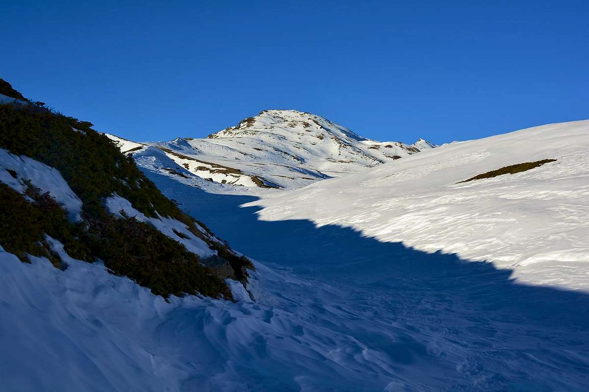
Comba Vertosan or Vertsan? Actually they have the same identical meaning, namely a Valley or Basin completely verdant. Even if the second name is used in the Valpelline below the Col Berlon, while the first is known just into the more Southern Vertosan Vallon or "Comba", later the Saddle of Joux (1.930m) above and the Vens Village (1.750m). In the second case, even that is the name of Leysser, is appropriate for a small secondary small vallon on the top of which there is a small lake of that name (2.418m). On the slopes of Monte Rosso di Vertosan (2.940m) and at the North Slope of Pointe Aouillette. A dispute own place names in an area that gave birth to Jean Baptiste Cerlogne, summit Poet in Val d'Aosta dialect or Franco-Provençal? It can be inside a rich alpine Region with a thousand steeples and 1000 different ideas, also a short drive ...So this area, like a spacious balcony above the Avise Municipalities (762m, 16 km. West by Aosta), St. Nicolas (1.196m; center), St. Pierre (661m; to the East), itcan also be divided in terms of topographical views in two different areas, below the Court de Bard Pointe Aouillette, two small Summit that characterize it at the entrance:
1) - the upper-middle area, that by Vétan Villages (Dessous Dessus, Villette and Granzetta) as well as by Alpages of Thoules and Grandes Arpilles, expands Westward above the St. Nicolas Municipality average hills and on the valley floor to Avise. This plateau, not very steep and below several grassy-detrital couloirs, dates back to the North through several villages and pastures reaching a small hollow where is located the Alpe isolated Chaz Creuse or Tsecreousa (2.398m) at the foot of the Pointe Aouillette or Oilletta (2.616m). From this last, that binds to the Pointe Leissé via an easy dividing crest with the small Vallon of Leysser, down the partition that reaches the Saddle and the small Mont de Joux (1.930m, 1.978m), before of the Vertosan Vallone and above the little Villages of Vens, Cerlogne Charbonnière and Cerellaz (1.750m, 1.580m, 1.263/87m, 1.254m).
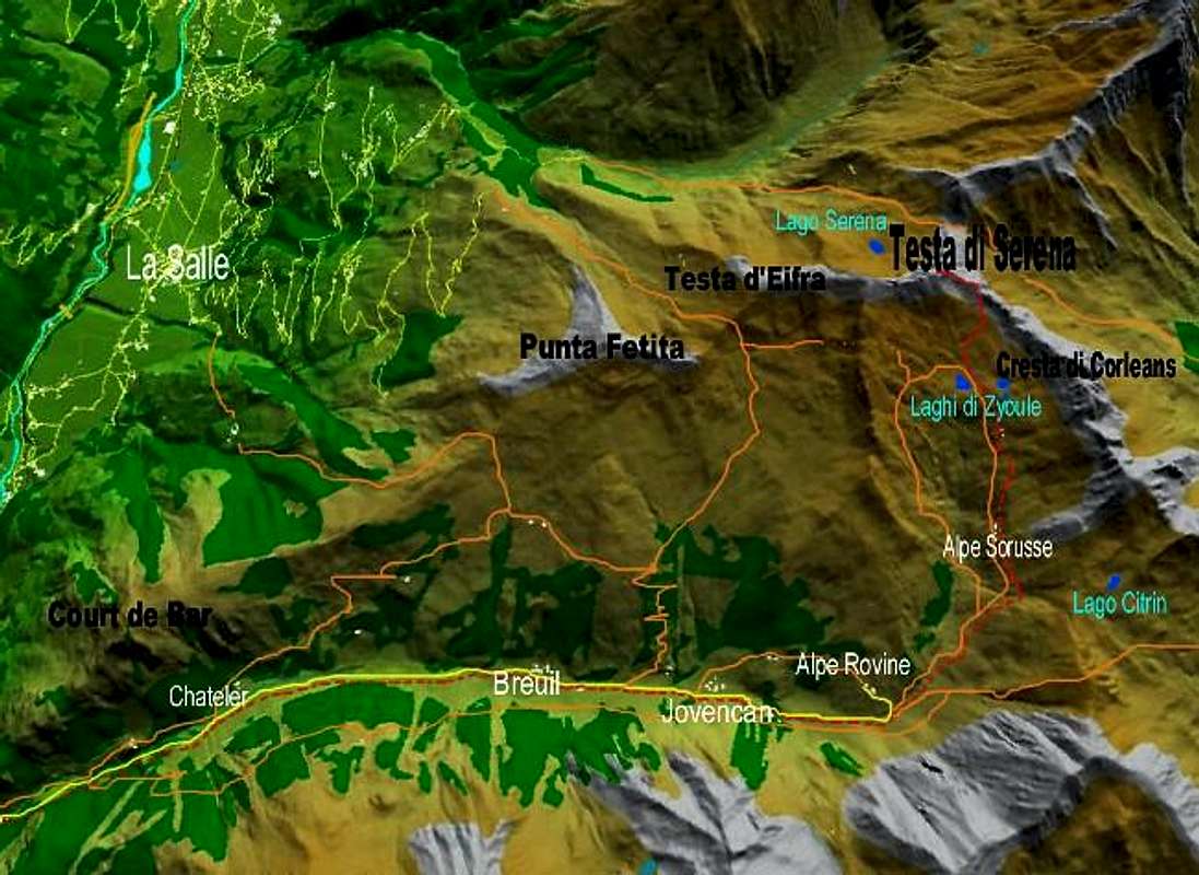
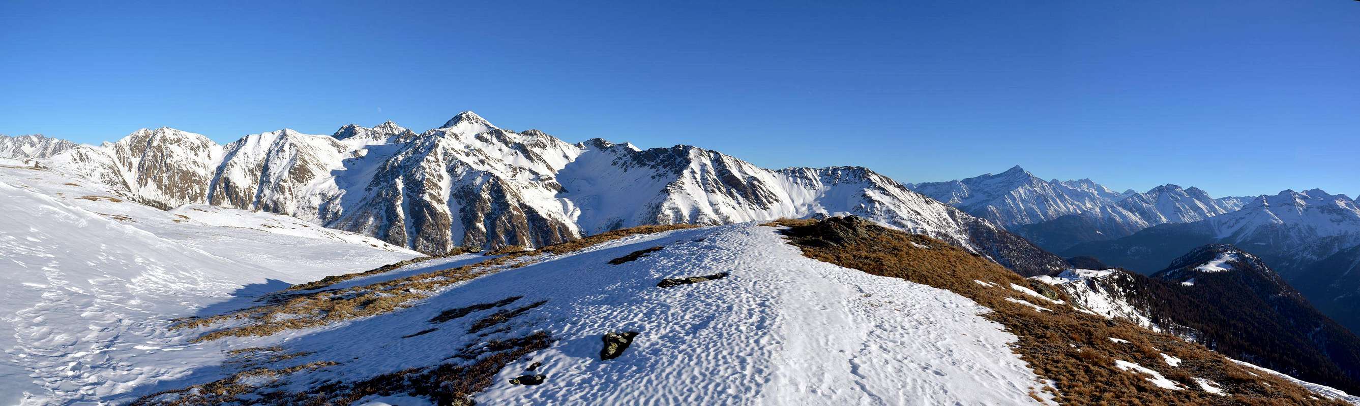
2) - the Western area that on the watershed with the adjacent Vallon of Planaval Vallon dating from the Court de Bard above the Village of Challancin (1.610m) to the North until it reaches, past the omonym hill, Punta Felita, Col Borromein and Testa dei Frà, the Testa (Head) of Serena (2.830m) above to Dziule Lakes, and the nearby Col Citrin (2.625m).
Comba di Vertosan o Vertsan? In realtà hanno lo stesso identico significato, ovvero Bacino o Vallone completamente verdeggiante. Anche se il secondo nome viene utilizzato nella Valpelline per indicare un vallone sotto il Col Berlon, mentre il primo é proprio del più Meridionale Vallone di Vertosan, oltre la Sella di Joux (1.930 m) e sopra il Villaggio di Vens. In questo secondo caso, cioé anche il toponimo di Leysser, viene appropriato ad un un valloncello secondario al sommo del quale esiste un laghetto di tale denominazione (2.418 m). Proprio alle pendici del Monte Rosso di Vertosan (2.940 m) e del Versante Nord della Punta Aouilletta. Una disputa toponomastica proprio in una zona che ha dato i natali a Jean Baptiste Cerlogne, sommo Poeta in dialetto valdostano? Può essere in Regione ricca di mille Campanili e 1000 idee diverse, anche a breve distanza ...
Quest'area, a guisa di gran balcone sopra i Comuni d'Avise (762 m; 16 Km. ad Ovest d'Aosta), St. Nicolas (1.196 m; centro) e St. Pierre (661 m; Est), può essere divisa anche dal punto di vista topografico in due differenti settori, sottostanti alla Court de Bard ed all'Aouilletta, le due piccole Sommità caratterizzantela all'ingresso:
1) - la zona medio-alta che, dai Villaggi di Vétan (Dessous, Dessus, Villette e Granzetta) nonché dagli Alpeggi di Thoules e Grandes Arpilles, si espande verso Occidente al di sopra dei Comuni di St. Nicolas nella media collina e di Avise sul fondovalle. Questo altipiano, non molto ripido e sottostante a diversi canaloni erboso-detritici, risale verso Settentrione attraversando numerosi villaggi ed alpeggi raggiungendo una piccola conca dove é collocata l'Alpe isolata di Chaz Creuse o Tsecreousa (2.398 m) ai piedi della Pointe Aouillette oppure Oilletta (2.616 m). Da quest'ultima, che si lega alla Pointe Leissé tramite facile cresta divisoria col Valloncello di Leysser, scende il divisorio che raggiunge la Sella ed il Mont de Joux (1.930 m, 1.978 m), prima del Vallone di Vertosan e sopra ai Villaggetti di Vens, Cerlogne, Charbonnière e Cerellaz (1.750 m, 1.580 m, 1.263/87 m, 1.254 m).
2) - l'area Occidentale che, partendo dallo spartiacque col Vallone di Planaval risale dalla Court de Bard sopra il Villaggio di Challancin (1.610 m) verso Settentrione fino a raggiungere, oltrepassato l'omonimo colle, Punta Felita, Col Borromein e Testa dei Frà, Testa di Serena (2.830 m), sopra ai Laghi Dziule, ed al viciniore Col de Citrin (2.625 m).
Getting There
BY CAR:
From TORINO, MILANO, etc: Motorway A5. Exit at IVREA or Quincinetto (PIEDMONT).
From IVREA Town: in West towards Pont Saint Martin, Donnas, Bard, Champdepraz,Aymavilles, to Villeneuve, Arvier, Avise Municipalities. From Courmayeur Resort: in East to Pré St. Didier, Morgex, La Salle, Saint Pierre Municipalities.
From Courmayeur or by Aosta Town towards Avise or St. Pierre From Avise (762m) we must go back in high. Here the same changes completely in East-northeast direction reaching the Village Cerellaz (1.254m). Short time you reach in quaint Charbonnière Village (1.263m). Then continue Eastward to the junction 1.278 meters, where the road splits sending a detour Northwest to the Clavel Village (1.480m), Cerlogne(1.480m), before the Col de Mont Joux (1.930m)) as well as the input of below Vertosan Comba. Do not follow this but the branch on the right until you reach the crossroads 1.233 meters just after Fossaz Hamlet (1.242m) and the next Chaillod(1.218m), now in the adjacent Commune of St. Nicolas (1.196m). From Saint Pierre-Pommier(783m), Champretavy, Rumiod, alternative just after Persod(1.351m), Ravoise, Chaillod, Clavel, Cerlogne(1.580m) to Vens small Villages (1.750m), with Regional Road in West-northwest. From this last towards Joux Saddle (1.930m): through short descent with the dirt road to Vertosan Vallon. From Saint Pierre-Chateau Sarrod de la Tour, Rumiod, Petit and Grand Sarriod (1.444/5m), Gerbore, Vetan Dessous (1.670m) and Dessus (1.737m), with Regional Road to Vetan Basin. From this, through dirt road, towards Genevrine Pasture, Chatalanez, Toules, Grand Arpilles Alps to Chaz Creuse Alp (2.398m).
From FRANCE: through the Mont Blanc Tunnel to Entrèves-crossroads to Vény/Ferret Valleys - Mountain Guides of Courmayeur - La Saxe Rock Gym - Courmayeur. By Little Saint Bernard Pass, closed since November until half May to La Thuile Valley - Pré Saint Didier - Courmayeur. It is not necessary to take Motorway A5: you can drive on SS.26, in the direction of AOSTA - IVREA - TURIN.
BY PLANE:
Aeroporto "Corrado Gex" Saint Christophe (Aosta).
Some Hikes even by Snowshoes
Walks
1) - Joux Saddle and Mont de Joux from Vens (1.930m, 1.978m). Diagonal Walk from St. Nicolas Common in Northwest or from Fossaz Hamlet (1.242m) to the North-northwest always with same path-route n° 14A/16/19; even in North, always through a branch of the trail n° 30A from Avise Commune near the Avise's Château to the North, but with start by the above Cerellaz Hamlet (1.254m); T/F; 0h'45 or 0h'30 from Vens or Fossaz Hamlets; 1h'45/2h'00 from Cerellaz, Fraction of Avise Common).
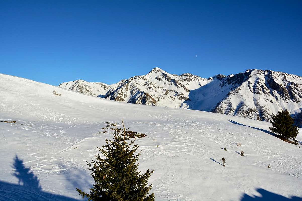
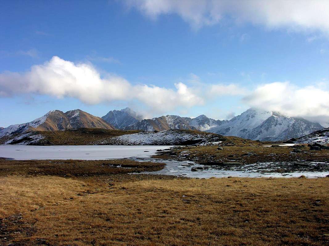
2) - Bettex Alp and Leysser Lake from Col de Joux (2.055m, 2.418m). Linear Walk to the North starting from Joux Saddle through the trail n° 19 concomitant with the upper dirt road until bypassing the two small Basins "Couiller Franche" arriving at the junction 1.996 meters. From this and through a short digression to the Norheast with the path n° 29C reach Alpe Bettex at the Western feet of Pointe Aouillette (2.055m; T/F; 0h'45/1h'30 from saddle). Wanting to transform Walk in a Hike, back on the farm dirt road and with this to continue along the "Ru Leysser" up to the altitude 2.041 meters where it turns exclusively in the small path n° 19 that progressively flexing in the Northeast, reaches Lake Leysser into the homonym basin (2.418m; E/F; 1h'15/1h'30 from alp). Both of these Tours are feasible in Rackets, but while the first is still in safe territory, the second requires good condition on above snowy slopes below Monte Rosso of Vertosan and Col Palettaz (2.940m, 2.707m; in this case EE/F+; from 3 to 4h'00).
3) - Crossing along Comba Vertosan towards the Alps Or de Breuil Jovençan Tronchey (1.845m, 1.866m, 1.954). This Trip can be a nice Walk, even with Snowshoeing, starting from the Col de Joux or a good Hike starting from Villages of Vedun or Cerellaz (1.512m, 1.254m) and then along the entire valley floor above the Municipality of Avise. In the first case you use the basic trail n° 19, which, gradually bending to the Northeast, or via the n° 3/8/20 that, rising gradually to the North, reaches just before Or de Breuil Pasture (1.845m). In short time and taking the valley floor with the concurrent private dirt road at n° 20 will reach the Alps Jovençan and Tronchey or immediately above the last Alpage of Or de Jovençan, just below Pointe de Dzioule (1.866m, 1.954m; E/F; 2h'00/2h'30 from Joux Saddle; 3h'15 from Vedun Village; 4h'30 by Cerellaz Hamlet).
Passeggiate
1) - Sella e Mont de Joux da Vens (1.930 m, 1.978 m). Passeggiata in diagonale dal Comune di St. Nicolas verso Nordovest oppure dal Villaggio di Fossaz (1.242m) a Nord-nordovest sempre con medesimo sentiero n° 14A/16/19; inoltre dal Comune di Avise presso il Château d'Avise verso Settentrione ma con partenza dal soprastante Villaggio di Cerellaz (1.254m) e sentiero n° 30A (T/F; 0h'45/0h'30; dai Villaggi di Vens oppure Fossaz; EF/1h'45/2h'00 dalla Frazione di Cerellaz sopra il Comune di Avise).
2) - Alpe Bettex e Lago Leysser dal Col de Joux (2.055 m, 2.418 m). Passeggiata lineare verso Settentrione partendo dalla Sella di Joux col sentiero n° 19 concomitante alla poderale fino ad oltrepassare le due piccole Combe "Couiller e Franche" arrivando al bivio 1.996 metri. Da questo e con una breve digressione a Nordest con sentiero n° 29C raggiungere l'Alpe Bettex alle pendici Occidentali della Pointe Aouillette (2.055 m; T/F; 0h'45/1h'30 dalla sella). Trasformando la Passeggiata in Escursione, rientrare sulla poderale e con questa continuare lungo il "Ru Leysser" fino alla quota di 2.041 metri dove diventa esclusivamente sentierino n° 19 che, flettendo progressivamente a Nordest, raggiunge il Lago Leysser (2.418 m; E/F; 1h'15/1h'30 dall'alpe). Entrambe le Gite sono fattibili in Racchette ma, mentre la prima é sempre in territorio sicuro, la seconda richiede buona condizione sui soprastanti pendii nevosi sottostanti al Monte Rosso di Vertosan ed al Col Palettaz (2.940 m, 2.707 m; in questo caso EE/F+; dalle 3 alle 4h'00).
3) - Traversata della Comba di Vertosan alle Alpi Or de Breuil Jovençan Tronchey (1.845 m, 1.866 m, 1.954 m). Questa Gita può costituire una bella Passeggiata, anche con Racchette da neve, partendo dal Col de Joux oppure una buona Escursione iniziando dai Villaggi di Vedun o Cerellaz (1.512 m, 1.254 m) e quindi percorrendo lo intero vallone al di sopra del Comune di Avise. Nel primo caso si utilizza il sentiero di base n° 19 che, flettendo progressivamente a Nordest, raggiunge, oppure tramite quello n° 3/8/20 che, salendo progressivamente a Nord, raggiunge il precedente appena prima dell'Alpe Or de Breuil (1.845 m); in breve e percorrendo il fondovalle con poderale concomitante al n° 20 si raggiungono le Alpi di Jovençan, Tronchey ed Or de Jovençan (1.866 m, 1.954 m; E/F; 2h'00/2h'30 dalla Sella; 3h'15 da Vedun; 4h'30 da Cerellaz).
Hikes
4) - Col and Court de Bard from Vens or by Joux Saddle (1.750m, 1.930m). Hike, even with Snowshoeing, departing from Vens Hamlet and passing by Joux Hill and Chatelet and Neuves Alps (1.750m, 1.762m) with trail base n° 2 to the Northwest, then through the following path n° 3/8 before towards West-northwest after West up to the Col de Bard. From here to the South through the wide grassy plateau and zigzaging amongst some small rocks in the final part easily to the Summit (EE/F; 3h'00/3h'30).
5) - Col Citrin from Sella or Col de Joux (2.484 m). Hike along the whole valley up to its extreme top thoroughfare, between Punta Valletta and the Mont Flassin. From Alpe Tronchey continue on farm dirt road in the Northwest to the junction immediately before the Alpe Rovine (2.082m); from this and flexing decisively towards the North to reach the path n° 10/VA to that of Sorace (2.205 m). A diagonal Northwest again leads to the hill (EE/F; 1h'30 from Alps Jovençan-Tronchey; 2h'00/2h'30 from Sella di Joux).
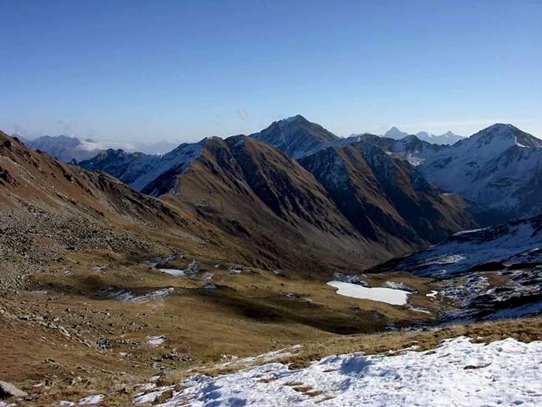
6) - Dziule or Dzioule Lochs by Joux Saddle (2.545m, 2.524m). Long and beautiful Hike through the usual Joux Sella with variable departures (St. Nicolas, Fossaz, Clavel Cerlogne etc.). From the Alps of Tronchey with the previous itinerary, reaching that of Sorace (2.093m); left to right (North) the trail to the Col Citrin instead continues Northwest through the n° 11 reaching the Alpe Berrio Noir (2.289m) below the Punta Valletta. Through in semi-circular ride by the same path, but gradually it becomes smaller, you reach the first of the lakes and almost, through a brief descent, immediately following the next ((E/F; 1h15/1h'30 from Alpe Tronchey; 2h'15/2h'35 from Sella di Joux).
Escursioni
4) - Colle e Court de Bard da Vens e con la Sella di Joux (1.750 m, 1.930 m). Escursione, anche in Racchette da neve, partendo da Vens e scavalcando il Colle o Sella di Joux Hill e gli Alpeggi di Chatelet e Neuves (1.750 m, 1.762 m) con sentiero di base n° 2 verso Ovest-nordovest e poi con il successivo n° 3/8 in direzione dapprima a Ovest-nordovest eppoi Ovest sino al Col de Bard. Indi a Sud per mezzo del largo plateau erboso zigzagando in mezzo a roccette nel tratto finale fino alla Cima (EE/F; 3h'00/3h'30). 5) - Col Citrin dalla Sella di Joux (2.484 m). Escursione lungo l'intero vallone fino al suo vertice estremo transitabile, tra la Punta Valletta ed il Mont Flassin. Dall'Alpe Tronchey continuare con poderale a Nordovest fino al bivio subito antecedente l'Alpe Rovine (2.082 m); da questo e flettendo decisamente verso Settentrione raggiungere con il sentiero n° 10/VA quella di Sorace (2.205 m). Un diagonale nuovamente a Nordovest adduce al colle (EE/F; 1h'30 dall'Alpe Jovençan-Tronchey; 2h'00/2h'30 dalla Sella di Joux).
6) - Laghi di Dziule o Dzioule dalla Sella di Joux (2.545 m, 2.524 m). Lunga e bella Escursione tramite la solita Sella di Joux con possibilità di variare le partenze (St. Nicolas, Fossaz, Clavel Cerlogne ecc.). Dall'Alpe di Trochey, con il precedente itinerario, raggiungere quella di Sorace (2.093 m); abbandonato a destra (Nord) il sentiero per il Col Citrin si continua invece a Nordovest tramite il n° 11 raggiungendo l'Alpe Berrio Noir (2.289 m) al di sotto della Punta Valletta. Con largo giro semicircolare tramite lo stesso sentiero, che però progressivamente si riduce, si raggiunge il primo dei laghi e quasi subito appresso il successivo ((E/F; 1h15/1h'30 dall'Alpe Tronchey; 2h'15/2h'35 dalla Sella di Joux).
Ascents
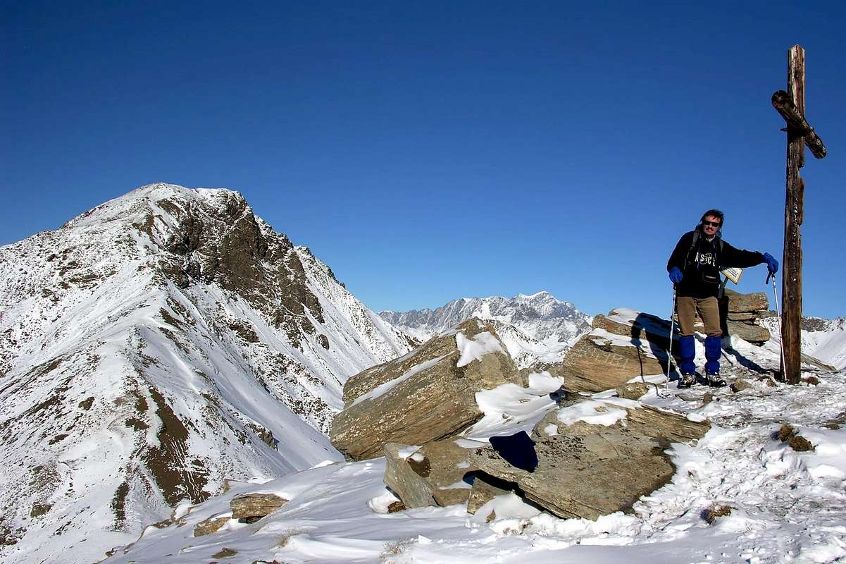
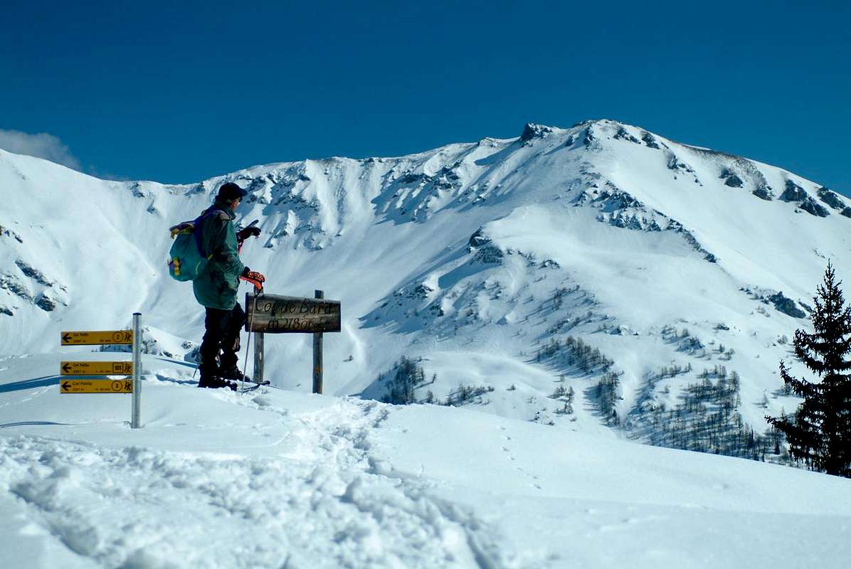
7) - Aouillette by Joux Saddle (1.930m) the artificial pond is surrounded by a wooden fence. The pavement ends here, where the road starts its gentle descent into the pleasant Valley of Vertosan. Park here in the convenient parking lot and hike along the trail to the right of the reservoir. Follow the path n° 29 as it enters the pine forest. There, it is easy to follow the same on Southwest Crest until the Summit (2.616m), where a small statue "under glass" of the Black Madonna is located (E/F: 2h'15/2h'30 by saddle).
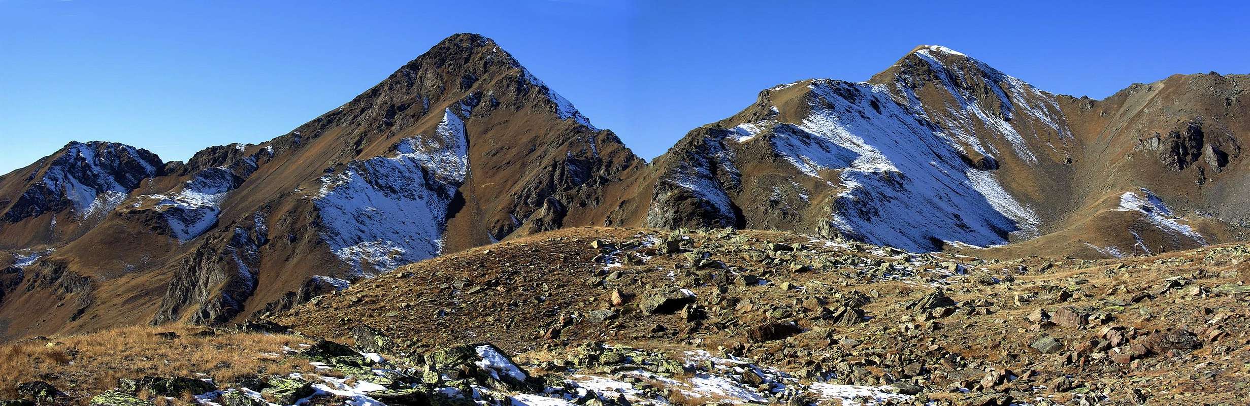
8) - Testa di Serena from first Dziule Lake (2.545m, 2.830m). From the first lake, left to the left the path n° 11, continue West through a moraine reaching a small carving (2.663m) at the beginning of the characteristically indented Corléans Crest (2.807m, 2.782m) to the Northeast towards the Punta Valletta (2.801m). From this where you can enjoy a wonderful panorama on Planaval Vallon with the Grande Rochère (3.326m) and in distance to the Mont Blanc Chain. Tourning left climb the last 150 meters about along the more than easy North-northeast Ridge, but paying attention in case of snow or "verglass" (E/F; 0h45/1h'00 from lake; 5h'00/5h'30 from the trailhead by Joux Saddle).
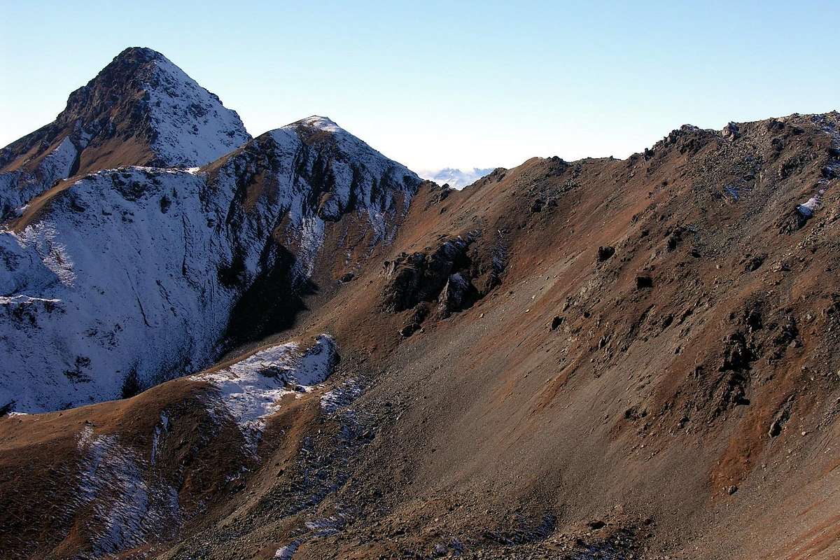
9) - Traverse by Col Citrin towards two Mont Flassin and Vertosan: (2.767m, 2.772m, 2.821/2m). From Vens (1.697/1.750m) reach with dirt road (ban on driving without permission) or through the trail n° 19 to the Northwest or even by Cerlogne (1.580m) with path n° 18/19 always towards Joux Saddle (1.930m), at the entrance on Vertosan Comba. After a short downhill, cross completely the same to the North with the dirt road that progressively bypass Neuves, Maisonnettes, Maison de Plan, Or de Breuil, Breuil, Jovençan Tronchey Pastures or Alps. After a brief digression to the South, reachs the last Alp of Rovine (2.089m), where ends (E/F; 1h'30/2h'00 from Saddle). From the junction on dirt road immediately before the Alpe Rovine and flexing decisively towards the North to reach the path n° 10/VA to that immediately above of Sorace (2.205 m). An enough long diagonal towards the Northwest again leads in short time to the hill ((EE/F; 1h'30 from Alps Jovençan-Tronchey; 2h'00/2h'30 from Sella di Joux). From the Citrin Hill climb on the watershed with Northwest Crest reaching the altitude of 2.611 meters and the Northern Antetop or Northwest Summit (2.767m), from which in a short time, after a small carving on the ridge, with always easy route to the true Summit (EE/F+; 1h'00 from the hill). From this easily go down to the altitudes 2.704m , 2.759m, 2.732m and at the next North Col of Vertosan (2.690m). A short climb on the West-northwest Crest leads to following Mont Vertosan (2.821/2m; EE/F; 1h'00 by Mont Flassin Southeast). The descent can be made available on the same via, or by enough easy through the Crest South-southwest to the South Pass of Vertosan (2.768m) and from there to the West on stony ground to the Comba Meanaz and path n° 20 towards Meanaz (2.325m) and Tronchey Alps (1.954m; EE/F; 1h'20/1h'40 by Mont Vertosan).
Ascensioni
7) - Aouilletta dalla Sella di Joux (1.930 m) con il suo laghetto artificiale circondato da staccionata in legno ove termina la poderale prima che la medesima inizi la sua breve discesa dentro il piacevole e verdeggiante Vallone di Vertosan. Dal comodo parcheggio in terra iniziare la salita lungo il sentiero a destra dello stesso seguendo il sentiero n° 29, che s'addentra nella pineta con cuscini di piante grasse violacee sul percorso. Da qui risulta facile continuare tramite lo stesso sulla Cresta Sudovest oppure appena al di sotto ed incontrando qualche piccolo nevato residuo insino alla Vetta (2.616m), ove é situata una statuetta "sotto vetro" della Madonna Nera (E/F: 2h'15/2h'30 dal Col de Joux).
8) - Testa di Serena dal primo Lago di Dziule (2.545 m, 2.830 m). Dal primo dei laghi di Dziule, abbandonato sulla sinistra (Sud) il sentierino n° 11 verso il secondo, salire ad un piccolo intaglio (2.663 m) dove inizia la frastagliata Cresta di Corléans (2.807 m, 2.782 m) a Nordest verso la Punta Valletta (2.801 m). Da qui salire con bel panorama sul sottostante Vallone di Planaval con la Grande Rochère (3.326 m) ed in distanza sulla Catena del Monte Bianco. Svoltando sulla sinistra risalire gli ultimi 150 metri circa lungo la più che facile Cresta Nord-nordest, ma facendo attenzione qualora in presenza di neve oppure "verglass" (E/F; 0h45/1h'00 dal lago; 5h'00/5h'30 dall'inizio alla Sella di Joux).
9) - Traversata dal Col Citrin ai due Mont Flassin e Mont Vertosan: (2.767 m, 2.772 m, 2.821/2 m). Da Vens (1.697/1.750 m) raggiungere con poderale (divieto di transito senza permesso) o tramite il sentiero n° 19 a Nordovest oppure da Cerlogne (1.580 m) col sentiero n° 18/19 sempre alla Sella di Joux (1.930 m), all'ingresso nel Vallone di Vertosan. Dopo breve discesa, percorrerlo tutto con direzione Nord per mezzo d'una poderale che oltrepassa in progressione le Alpi di Neuves, Maisonnettes, Maison de Plan, Or de Breuil, Breuil, Jovençan, Tronchey e, dopo breve inversione a Sud, raggiunge l'ultima di Rovine (2.082 m), ove termina (E/F; 1h'30/2h'00 dalla Sella di Joux). Dal bivio sulla poderale subito antecedente l'Alpe Rovine e flettendo decisamente verso Nord raggiungere con il sentiero n° 10/VA quella appena superiore di Sorace (2.205 m). Un' abbastanza lungo diagonale nuovamente a Nordovest conduce in non molto tempo al colle ((EE/F; 1h'30 dall'Alpe Jovençan-Tronchey; 2h'00/2h'30 dalla Sella di Joux). Dal colle risalire la Cresta spartiacque o Nordovest raggiungendo la quota 2.611 metri e l'Antecima Nord (2.767 m), dalla quale in breve, dopo un piccolo intaglio sulla cresta, sempre con facile percorso alla vera Cima (EE/F+; 1h'00 dal colle). Da questa scendere facilmente alle quote 2.704 m, 2.759 m, 2.732 m ed al successivo Colle Nord di Vertosan (2.690 m); una breve risalita sulla Cresta Ovest-nordovest conduce al Mont Vertosan (2.821/2 m; EE/F; 1h'00 dal Flassin). La discesa può essere effettuata con stessa via, o tramite la Cresta Sud-sudovest al Colle Sud di Vertosan (2.768 m) e da questo su pietraie ad Ovest verso la Comba Meanaz ed al sentiero n° 20 a Meanaz (2.325 m) e Tronchey.
Campings
Remember that free camping is forbidden (except for emergency reasons, over 2.500m, from darkness until dawn).
Mountain Condition
Meteo: you can find all the needed informations at the official site of the Valle d'Aosta Region:
"Guida dei Monti d'Italia-Alpi Pennine" (Vol. I°) di Gino Buscaini-Club Alpino Italiano/Turing Club Italiano, Luglio 1971.
"80 itinerari di Escursionismo Alpinismo e Sci Alpinismo in Valle d'Aosta", di Osvaldo Cardellina, Ed. Musumeci, Giugno 1977 (in Italian); seconda Ed. Luglio 1981; terza Ed. Luglio 1984; (in French), prima Ed. Febbraio 1978; seconda Ed. Marzo 1980.
"La Vallée d'Aoste dans votre poche" di Giuseppe Lucca Ed. Musumeci 1978.
MAPS:
Kompass "Monte Bianco Valle d'Aosta Sentieri e Rifugi" Carta turistica 1:50.000.
Kompass "Gran Paradiso Valle d'Aosta Sentieri e Rifugi" Carta Turistica 1:50.000.
I.G.C. Istituto Geografico Centrale Torino "Massiccio del Monte Bianco" (n° 4), Torino, 1998 1:50.000.
Studio F.M.B. "Monte Bianco-Mont Blanc", Bologna 1988 1:50.000.
I.G.C. Istituto Geografico Centrale "Carta dei sentieri e dei rifugi" 1:25.000.
Parents refers to a larger category under which an object falls. For example, theAconcagua mountain page has the 'Aconcagua Group' and the 'Seven Summits' asparents and is a parent itself to many routes, photos, and Trip Reports.


 3165 Hits
 79.78% Score
 11 Votes