
|
|
Mountain/Rock |
|---|---|
|
|
44.75930°N / 14.98580°E |
|
|
5498 ft / 1676 m |
|
|
Google Earth
Since Google has blessed us with its magical Google Earth software you can visit any corner of the world from the chair parked in front of your computer. Thankfully Velebit is amazingly clear so you can discover its corners and see for yourself how it looks from the above and where are the places this page is dedicated to.Each geographical point of interest described on this page has coordinates on the top of its section. You can use these coordinates with Google Earth’s fly to search engine. Just copy the coordinates (like it is written, with coma) and paste them into fly to tab and press enter. And, of course, enjoy the flight!
Intro
 Rozanski Kukovi from Krajacev Kuk (1659m): right of the middle is Gromovaca (1676m)
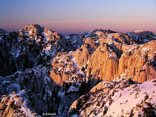
Velebit is kingdom of karst. All the beauties which are epitomized under the word karst were taken to the next level here. Rozanski Kukovi, a boiling sea of white limestone, huge waves raised by imaginable, yet unnoticeable storm we call geological forces, are highlight of Velebit karst. One must wonder what happened here, why was this area of rock so special or different to be formed this way, rarely found on one place in such concentration and grandiosity. If you wonder how Rozanski Kukovi look try to imagine the conglomeration of wild cliffs, towers, domes, obelisks and teethed heads made of white limestone. They are separated by deep holes, chasms and ravines whose bottoms are buried under huge boulders or disappear somewhere deep in bowels of Velebit or are connected with razor sharp ridges, natural passes and doors. It is impossible to find any kind of order in this chaos of cliffs and chasms. This is not just white rocky desert. All is decorated with isolated beech, fir and spruce trees and inevitable dwarf pine which grows on most unbelievable places. Exposure to terrible Bura wind and climate made beeches look like bushes as they are stunted to form beyond recognition. Spruces and firs are taller so they are crippled and don’t have any branches towards the direction from which Bura blows. Rozanski Kukovi, together with nearby Hajducki kukovi, is one of most beautiful and impassable areas on whole Velebit.
 |  |  |  |  |
Overview
 Rozanski Kukovi from Crikvena (1641m): left is Novotnijev Kuk (1620m), right Varnjaca (1634m)
Word kuk in Croatian means hip. It has been accepted on whole area of Dinaric Alps as word which also describes peaks that are made of steep rock or cliffs. Kukovi is plural of the word. In Rozanski Kukovi group there are around 40 hips that exceed 1600m. They are scattered on the area of some 18km2.
In 1969 Rozanski and Hajducki Kukovi were declared strict nature preserve, which is highest form of protection, on area of around 22 km2. Any kind of human work is forbidden here. Other reason why they are so well preserved in their primeval form is because Mother Nature took care of it. They are so impassable that even today there are places where man didn’t set his foot on! Since 1999 Rozanski Kukovi are part of North Velebit National Park but status of strict preserve, inside national park, remained.
First who dared to enter, once feared chaos of Rozanski Kukovi, were mountaineers. Members of Croatian Mountaineering Society build Rossijevo Skloniste refuge in 1929 in the heart of the group and named many cliffs and peaks after deserving pioneer explorers of Velebit. Pasaric (Pasaricev Kuk), Hirc (Hircev Kuk), Rossi (Rossijev Kuk), Novotni (Novotnijev Kuk), Krajac (Krajacev Kuk), Poljak (Poljakov Toranj) and Premuzic (Premuzicev Toranj) got ‘their’ peaks and cliffs.
Thanks to eng. Ante Premuzic, man of great enthusiasm and vision, Rozanski kukovi are not so unapproachable as they use to be. From 1930-1933 he hired workers from the villages at the foot of the Velebit to build a tourist path that will make exploring of Velebit much easier. Legendary Premuziceva staza path, a true masterpiece, since stretches from Zavizan on North Velebit till the end of Mid Velebit on Baske Ostarije. Part which winds through white stormy waves of Rozanski Kukovi and makes it a pleasant walk through this open karst museum, almost without oscillations in altitude, is its most beautiful section.
In 1994, Slavko Tomerlin, well known Velebit enthusiast, path and refuge builder, penetrated deeper than anybody into wilderness of Rozanski Kukovi and marked few beautiful climbing trails. Especially beautiful is the one that leads from Rossijevo Skloniste refuge to Vratarski Kuk (1676m), once most unapproachable cliff. Path uses razor sharp ridges, which rise above wild chasms. Of several other paths it is worth to mention here the one which descends into Varnjaca ravine which is over 100m deep and has eternal snow on its bottom. Path has climbing character, it is secured and only for experienced mountaineers.
Yet, Rozanski Kukovi still hide many secrets, especially underground which is very rich with speleological objects. Year 1993 marked new era in this field of Velebir research. Then, in nearby Hajducki Kukovi group, Lukina Jama hole was discovered. With depth of 1392m it is 9th deepest hole in the world but most perpendicular. In 1995 Slovaks discovered, near the summit of Mali Kuk (1565m) which is placed on SE corner of Rozanski Kukovi, another great/huge object. Later it was named Slovacka Jama or Slovakia after Slovaks who found it. It is 1268m deep and second deepest hole on Velebit. Many surprises are waiting to be discovered in future to come.
Note: Position of the page is that of the Rossijevo Skloniste refuge - 44°45'56.02"N, 14°59'14.95"E (approximately)
 |  |  |  |  |
General Location
 Evening on Krajacev Kuk (1659m), looking towards Veliki Kozjak (1629m)
Rozanski Kukovi group is placed in the central part of North Velebit.
On the W Rozanski Kukovi rise above huge area of forested karst chaos, Cipala & Smrceve Doline area. It separated Rozanski Kukovi from seaboard streak of peaks. Most notable peaks in Rozanski Kukovi which rise above it are Gromovaca (1676m), Hircev Kuk (1636m), Premuzicev Toranj (1620m) and Crikvena (1641m). More about Smrceve Doline can be found below in their own section.
On the E group falls steeply towards Skrbina Draga (side valley of larger Lomska Duliba valley), Lubenovacka Vrata (1474m) pass, which separate or connect them with Hajducki kukovi. South of Lubenovacka Vrata pass is Plancice valley which ends with Veliki Lubenovac field. Vratarski kuk (1676m) dominates on this side of group.
On the N Rozanski Kukovi are connected with Zavizan group by Cepuras (1565m).
On the S is Veliki Lubenovac field and forested valley which separates group from Goli Vrh (1669m). Above Veliki Lubenovac is Mali Kuk (1565m) while most eminent on this edge of Rozanski Kukovi is Krajacev Kuk (1659m).
Most eminent peaks in Rozanski Kukovi are:
Gromovaca (1676m) on the NW
Vratarski kuk (1676m) above Lubenovacka Vrata pass, eastern edge
Krajacev Kuk (1659m) on the S edge of the group
Krajacev Kuk II (1648m)
Crikvena (zapadna = western) (1641m)
Hircev Kuk (1636m)
Crikvena (istocna = eastern) (1635m)
Varnjaca (1634m)
Pasaricev kuk (1630m) above Rossijevo Skloniste refuge
Premuzicev Toranj (1620m)
Novotnijev Kuk (1620m)
nameless peak (1618m), placed north of Gromovaca and south of Cepuras
Rossijev Kuk (1615m)
Vratarski Kuk (1609m)
 |  |  |  |  |
Gromovaca (1676m)
44°46'21.77"N, 14°59'2.44"EGromovaca shares, together with Vratarski Kuk (1676m), the title of being the highest peak in Rozanski Kukovi. It is placed on the NW corner of central (compact) part of Rozanski Kukovi. It is typical white rocky peak, partly overgrown with stunted spruces and beeches with inevitable dwarf pine. Towards W it falls into wide Smrceve Doline area which are placed between Rozanski Kukovi and seaboard streak of peaks. On the N, E and S Gromovaca descends into surrounding chaos of Rozanski Kukovi. All around are deep rocky depressions and funnel shaped holes. Depending of viewing angle Gromovaca has a shape of a steep cone or nicely shaped dome. From anywhere you look it is clear that it is one of if not the highest peak in the group.
Eastern slopes of Gromovaca are traversed by Premuziceva Staza path. From it marked path has reached the summit. Ascent lasts some 15-20mins and is quite steep. At first it leads through stunted beeches till it reaches very steep summit head where use of hands is frequent.
View from the summit of Gromovaca is probably most beautiful among the peaks of Rozanski Kukovi. It is because it has most beautiful sea view which is quite restricted from other peaks since whole group is quite far behind the seaboard streak of peaks which obscures it. Towards other parts of the group and North Velebit it is as good as from other peaks.
 |  |  |  |
Pasaricev Kuk (1630m)
44°45'58.75"N, 14°59'16.62"EPasaricev Kuk is one of most recognizable and photographed peaks in Rozanski Kukovi because Rossijevo Skloniste is almost glued to its beautiful SW white limestone cliffs. It is placed in the heart of the group but on its western edge above Smrceve Doline area. Summit ridge of Pasaricev Kuk stretches in W-E direction. From all but northern side, which is least steep and almost completely overgrown by stunted beech, spruce and dwarf pine, Pasaricev Kuk is steep and well defined. Esthetically most beautiful are SW cliffs above the refuge. On the south, by the refuge, is nice meadow Jerkovic Dolac. Wildest is eastern side which falls almost perpendicularly into deep and wild funnel shaped hole. Premuziceva Staza path is carved into this slope and that is one of its highlights on the way through the chaos of Rozanski Kukovi. On the other side of the hole is Novotnijev Kuk (1620m).
Pasaricev Kuk is not marked since marks would only ruin the beauty of its cliffs. The only logical approach leads through a steep couloir right above the refuge.
 |  |  |
Vratarski Kuk (1676m)
44°45'54.69"N, 15° 0'1.57"EVratarski Kuk is, together with Gromovaca (1676m), joint highest peak of Rozanski Kukovi. Being placed on the western edge of the group, quite isolated and high, Vratarski Kuk is the monarch of whole group. From all but eastern side it rises above the surrounding chaos of holes and chasms. Its eastern side is highest and wildest where it falls steeply towards Lubenovacka Vrata (1474m) pass that separate or where Rozanski Kukovi and Hajducki Kukovi touch. Side is made of torn white limestone cliffs and looks like huge boulder slope. It was named Lubenice (watermelons) by Tatek (more below). On the west is huge chasm which disappears somewhere in the bowels of Velebit. Bottom cannot be seen. On the shoulder which gradually descends towards north is Vratarsko Sedlo pass over which path from Lubenovacka Vrata approaches.
Unlike Gromovaca, the other highest peak in Rozanski Kukovi, Vratarski Kuk was isolated and hardest peak in the group to approach till mid 1990’s. Then came Slavko Tomerlin – Tatek (more about him in overview section) and opened 3 marked paths which lead to Vratarski Kuk. Northern one leads from Rossijevo Skloniste refuge – Skrbina Draga path and climbs very steeply from Fabin Dolac till Vratarsko Sedlo where it joins other two routes. One route leads from Lubenovacka Vrata pass via Lubenice to Vratarsko Sedlo pass. It is quite tough scramble up the wildest side of Vratarski Kuk. Last to mention but most beautiful of 3 is ridge route which leads from Premuziceva Staza path, dozen minutes south of Rossijevo Skloniste and approaches via Rossijev Kuk (1615m) and Novotnijev Kuk (1620m). This is route par excellence in Rozanski Kukovi from which fantastic views spread upon the surrounding chaos. Like every story this one has two sides too. Rozanski Kukovi are strict preserve which means any kind of human work is forbidden here and Tatek broke the law when he opened the new paths in the group. Of course, he wasn’t sanctioned as he is probably most deserving Velebit enthusiast in past 60 years. Honestly speaking the only damage to the nature are cut branches of dwarf pine where it was necessary and drawn marks.
After Tatek opened new routes and first hikers reached the summit of Vratarski Kuk it was declared the king of Velebit views. People were so thrilled by the wide and beautiful views and new, unknown angles. Indeed, Vratarski Kuk is fantastic view point from which you can see most of Velebit. The only thing missing is sea views because North Velebit is very wide here and Vratarski Kuk is far behind the seaboard streak of peaks.
 |  |  |
Varnjaca (1634m)
Triple headed ridge of Varnjaca graces southern central part of Rozanski Kukovi. It is placed between Novotnijev Toranj (1620m) and Varnjaca chasm, on the north, and Crikvena (1641m), on the south. Varnjaca is N-S oriented and has beautiful cliffs on the western and eastern side. Its ridge is around 400m long and on placed only few meters wide with W and E face falling steeply on each side.Varnjaca is one of more picturesque cliffs in Rozanski Kukovi. Its smooth western white limestone cliffs take most of our attention on the way between Rossijevo Skloniste refuge and Crikvena. Posing like a model near the comfortable path it is probably one of most photographed peaks in Rozanski Kukovi.
Tatek marked the route via its panoramic narrow ridge in 1994 after clearing lot of dwarf pine which stood in a way. There are two ways to climb it. Either by turning right on the first junction on the path from Premuziceva Staza to Varnjaca chasm or via its own path which branches little bit further south towards Crikvena. Route over Varnjaca has climbing character and is only for experienced hiker. Walk over ridge is exciting and beautiful. It is quite exposed on places but rock is compact and not slippery.
View from the summit/ridge is beautiful upon surrounding chaos but it also spreads widely. Only fraction of sea is visible from Varnjaca as from most peaks of Rozanski Kukovi.
 |  |  |  |  |
Varnjaca chasm
44°45'46.05"N, 14°59'33.99"E (approximately)Varnjaca is wild, 100m deep chasm (from lowest point around the edge), with smooth walls around. It is placed between Novotnijev Kuk (1620m), on the north, and Varnjaca (1634m), on the south. On the bottom which is at 1350m eternal snow lies. Peaks around rise almost 300m above its bottom. View from its edge into it and towering cliffs around epitomizes all that Rozanski Kukovi are while descent to its bottom tells its own story about the wilderness of Rozanski Kukovi group.
Slavko Tomerlin – Tatek equipped the route with fixed ropes, pegs and ladders in 1994 and made possible for more experienced hikers to enjoy and admire this amazing corner of Rozanski Kukovi.
 |
Crikvena (1641m)
44°45'35.51"N, 14°59'24.70"E (approximately)If Vratarski Kuk is monarch of Rozanski Kukovi, Crikvena is certainly his queen. It is placed in the southern half of the group, on the western edge above Smrceve Doline area. Crikvena has two heads, rocky domes. Western is higher while eastern has 1635m. Between them is narrow saddle. South of saddle is narrow couloir between the smooth cliffs of both heads through which Premuziceva Staza continues towards south. It is surmounted by built steps. West of Crikvena is close Premuzicev Toranj (1620m). On the north is narrow ridge which connects it with central part of the group. Around it are deep and wild holes. On the south and east is undulating area of the group where chasms and holes are mostly under beech and spruce forest.
Being right above the Premuziceva Staza path, Crikvena is, together with Gromovaca, mostly climbed peak in the whole group. From the saddle which separates main summit from eastern one, it takes some 5mins of moderate climbing over the steep cliffs, which have plenty of holding points.
View from the summit is wide and beautiful and it includes some sea and islands which is partially visible behind huge forests of Smrceve Doline area. View is also beautiful towards the surrounding area of Rozanski Kukovi.
 |  |  |  |
Krajacev Kuk (1659m)
44°45'0.24"N, 14°59'47.31"EKrajacev Kuk is southern most of eminent peaks in Rozanski Kukovi. It is massive rounded and isolated peak which dominates the surroundings. North and south sides are very steep while western and eastern are more like rounded ridge. On the north in undulating area of chasms, holes and funnel shaped depressions, that is mostly overgrown by beech and spruce forests. It separates it from central part of the group. On the east it descends towards Plancice valley that is stretching south of Lubenovacka Vrata (1474m) pass and separates Rozanski from Hajducki Kukovi. On the south is forested valley which separates it from Goli Vrh (1670m). On the west is SE corner of Smrceve Doline area.
For a long time Krajacev Kuk was considered to be highest peak of Rozanski Kukovi and second highest of North Velebit. Its altitude was 1690m till new measurements lowered it to 1659m which placed it behind Gromovaca and Vratarski Kuk which have 1676m. Never mind the altitude, Krajacev Kuk still sticks on the south of the group and from anywhere you see it, it appears to be very high, maybe even highest in the group.
Its summit has been approached by marked path which is made of two branches that join below the summit. One branch leads from Premuziceva Staza path and the other from Lubenovac – Premuziceva Staza path. Ascent via both is very steep.
View from the summit is wide and beautiful. It includes some sea while it mostly oriented towards inner North Velebit and continent. View extends far towards south and South Velebit.
 |  |  |  |  |
Smrceve Doline
Smrceve Doline (spruce valleys) is huge area of undulating forested karst chaos. This is predominantly rocky terrain, but also with lot of exposed bare soil, strewn with holes and funnel shaped depressions, all of which is mostly covered with beech and spruce forests. Above the forests some white cliffs and smaller peaks stick. Smrceve Doline are have dimensions of roughly 6km in N-S and 2.5km in W-E direction. Altitude of the area is between 1350-1500m. On the N is Zavizan group or to be exact Balinovac (1601m), Veliki Zavizan (1676m) and Debela Kosa (1637m) peaks. On the S is Alancic-Rozanski Vrh with Rozanski Vrh (1638m), Seravski vrh (1661m) and Goli Vrh (1670m) peaks. Rozanski Kukovi are on the E while on the W are peaks in the seaboard streak like Beli Kuk (1474m), Klanac (1512m) and Lisac (1541m).This is one of the wildest and loneliest areas on whole of Velebit. Only one marked path passes through small part of the area, the one which ascends from Velike Brisnice to Rozanski Kukovi. Stories say that outlaws buried their treasure here. On the rock above the entrance in one small cave there is still a recognizable sign Jerko 1843, probably one of treasure seekers and material around the entrance seams to be excavated. Judging after the name it seams that there was a lot more spruce here in passed times. Beech is now predominant tree in spruce valleys, although there is still lot of spruce and fir.
 |  |
Hike Advices
It is important to emphasize that moving outside of marked paths is dangerous in Rozanski Kukovi and reserved for highly experienced mountaineers with climbing gear. But as soon as one enters this kingdom of chasms, cliffs, stunted vegetation and dwarf pine that realization imposes itself. For anyone except mention group of people this is impassable terrain and just thought of getting lost here makes you bristle as behind each peak or ridge another chasm or hole lurks.Number of possible combinations to visit Rozanski Kukovi is huge. Easiest approach leads from either Zavizan or Alan pass via fabulous Premuziceva Staza path. Both trailheads are accessible by car and route begins on high altitude. From Zavizan this is almost effortless approach with very little ascents or descents which were anyway so gently surmounted. From Alan is little bit tougher but still not difficult. Most usual is passage through Rozanski Kukovi from Zavizan to Alan which lasts 6h. You can sleep over at Alan and return the other day same way to Zavizan.
For those that want to see more of Rozanski Kukovi than Premuziceva Staza has to offer here is more beautiful but more demanding 2 day combination. From Zavizan go to Rossijevo Skloniste. From there go to Vratarski Kuk via Rossijev Kuk and Novotnijev Kuk (ridge route). Descent via Vratarsko Sedlo and Lubenovacka Vrata pass to Veliki Lubenovac where you will sleep over at the hut/refuge. On the second day climb Krajacev Kuk from Lubenovac and continue via Crikvena to Rossijevo Skloniste from where it is same way back to Zavizan.
Those that want to feel real magnitude of Velebit and Rozanski Kukovi should ascent from Adriatic Road above the coast or Velike Brisnice village, one hour above Adriatic Road, from where access to Rossijevo Skloniste refuge lasts around 5h. Possibilities are now numerous but those that come from the coast are certainly strong hikers and won’t find this fantastic combination undoable. From the refuge go to Vratarski Kuk via Rossijev Kuk and Novotnijev Kuk (ridge route). Descent via Vratarsko Sedlo and Lubenovacka Vrata pass to Veliki Lubenovac where you will sleep over at the hut/refuge. On the second day climb Krajacev Kuk from Lubenovac and continue via Crikvena to Rossijevo Skloniste and further to Zavizan where it is best to sleep over. Tomorrow you can do some trips in Zavizan group before returning to Brisnice where your car waits. From Zavizan begin descending to Klada. Around hour below Zavizan turn left towards Alan via seaboard terrace. At Plancice meadow turn right to Brisnice. Of course, if you are strong hiker you can do this descent on the second day after reaching Zavizan but it is very tough.
 |  |  |  |  |
Getting There
There are 4 different starting points to reach Rossijevo Skloniste refuge in the heart of Rozanski Kukovi. How to reach them is described with each route. Center of the region is Senj town bellow Velebit.By Plane
you can reach Zagreb. From Zagreb you have to go to Senj by bus. Info about flights find on Croatia Airlines site.
By Bus
If you are coming by bus from Zagreb you can look for time table towards Senj on the pages of Bus station in Zagreb
From Senj to each starting point you have to catch coastal bus from Rijeka to Zadar (plenty per day).
By Car
There are 3 main directions to come to this area, from Rijeka, Zagreb or Zadar.
From Rijeka:
This route is suitable if you are coming from western Europe, via Trieste (Italy).
Trieste - Rijeka 70 km
Rijeka – Senj 74 km
From Zagreb:
This road is suitable if you are coming from eastern or central Europe via Ljubljana (Slovenia), Maribor (Slovenia) or Budapest (Hungary).
Ljubljana - Zagreb 138 km, Maribor - Zagreb 113 km, Budapest - Zagreb 347 km
Zagreb – Karlovac – Zuta Lokva - Senj 184 km
From Zadar:
Zadar – Senj 155 km
Look for current road conditions in Croatia on the page of Croatian Automobile Club (HAK)
 |
Maps
 |  |  |
When To Climb
 On, or better to say somewhere above, Premuziceva Staza path in winter
Learn more about climate on Velebit main page.
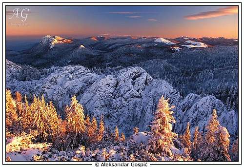
Winter season: lasts from beginning of December till end of April. Because of large amounts of snow Rozanski Kukovi are almost unapproachable in winter!! Premuziceva Staza path, which is on many places cut into perpendicular cliffs, completely disappears under thick layers of snow. All that remains are very steep and icy slopes so on many spots you’ll need to improvise. This is very dangerous since there are many holes and chasms by path. Full winter equipment is necessary and tons of experience. Since almost no one goes into Rozanski Kukovi in winter it is very likely that Rossijevo Skloniste refuge will be buried under snow and you won't be able to enter! Don't even think that you'll be able to dig it out since snow is usually cement hard! You have to be prepared for all options. Beside this most dangerous factor is Bura wind. Rozanski Kukovi are above forest line which means completely exposed to this fierce wind.
Spring season: is very short here. It lasts from end of May till mid June. For those that like greenery this is most beautiful period to visit. In June there is lot of flowers on the meadows and it still is not hot. Forest turns green around May 20th while grass at the beginning of June. If weather is unsettled there is possibility for afternoon thunder storms in June.
Summer season: Lasts from end June to mid September. Weather is generally very good, lot of clear, warm or even hot days. In July and August there is also not much of daily cloud development. If you are starting from the sea level do it as early as possible. Highest temperatures in this (high) region of Velebit rarely get above 23°C in July and August. Bura blows year round but in summer rarely exceeds 100kmh.
Autumn season: If you want to catch autumn colors be sure to be here between September 20th and October 5th. After this date leaves are gone. This is beautiful period to visit. Days are chilly and very clear while mountain is decorated in autumn colors. From my, over a decade long, observations there is more of beautiful weather in October than in September. Snow can fall by the end of August but won’t remain on ground longer than day or two. November is not good month to visit because leafs are gone and there can be no snow, but generally in the other half it should be already on the ground. This changes from year to year.
 |
Mountain Conditions
Conditions on Velebit are very well known thanks to Zavizan meteo station, which is observing weather since 1953. On WeatherOnline & DHMZ (Croatian Meteorological and Hydrological Association) sites you can find current data for Zavizan and recently even forecast for Zavizan on WeatherOnline.Here are the links where you can find out about the current weather on Velebit (Zavizan) and forecast for Croatia:
WeatherOnline:
WeatherOnline home page
Croatia at WeatherOnline,
Zavizan at WeatherOnline
Croatian Meteorological and Hydrological Association (DHMZ):
DHMZ home page
DHMZ Forecast page
DHMZ 7 Day Forecast for Croatian and cities and places World wide, including Zadar and Gospic
Current Weather Conditions in Croatia including Zavizan, Gospic and Senj
Snow Depth's in Croatia
 |
Objects
Rossijevo Skloniste (1580m) refuge was build and opened on August 15th 1929 by Croatian Mountaineering Association. It was named after botanist Ljudevit Rossi (1850-1932), one of famous pioneer explorers of Velebit. It is placed just by white limestone cliffs of Pasaricev Kuk (1630m) in the heart of Rozanski Kukovi group at its western edge. From the small terrace in front of refuge is beautiful view on Smrceve Doline forested valley and over them onto sea and islands. Just bellow is deep basin and Hircev Kuk (1636m) on its other side.Refuge is fantastic base to explore Rozanski Kukovi but is not very popular since it does not offer anything more than refuge. People mostly just pass by on a way from Zavizan to Alan or vice versa or visit as part of daily trips from Zavizan or Alan huts. Inside there is space to accommodate 10 people, a table, wood-stove and water cistern. Water is problem because capacity of cistern is small so during summer droughts water is early spend. Be sure to have enough water. Evenings and sunsets are beautiful from the refuge. Especially beautiful are moonlit nights when surrounding white cliffs glow.
Since opening refuge was renewed in 1955, 1969 and 1991.
Zavizan hut (1594m) (2.30-3h from Rossijevo Skloniste refuge) stands on top of grassy slopes, bellow the Vucjak (1644m) peak in Zavizan group. It is also meteo station so is open year round. It has electricity, water cistern, phone (GSM signal also) and 28 beds. Kitchen is at disposal to prepare your own food. Today hut stands on foundations of old Krajaceva Kuca hut which was build by Croatian Mountaineering Association and opened on August 15th 1927. It was named after dr. Ivan Krajac, one of pioneer explorers of Velebit and those days president of association. During the second world war it was destroyed. In 1952 association build new hut and opened it on July 27th 1953. In 1965 it was renewed and enlarged. Zavizan hut is very popular year round, especially in summer season when is very crowded and has small capacity. It should be desperately enlarged again.
Kuca na Alanu (1340m) hut stands 500m from Veliki Alan (1380m) pass, on the seaboard side. Alan road (macadam) connects the shore with Stirovaca forest on Velebit and Krasno village. Hut is at the edge of the forest bellow Alancic (1611m) peak and meadows around pass. On those meadows are rusty pillars of former cable-car which was used to transport wood to the shore (to Stinica).
It was build in 1960 as foresters house. Forestry service gave 2 rooms to mountaineers to be used as refuge. In 1990’s it was completely handed over to mountaineers. It is open all year and managed in summer season when is partially supplied with drinks. You can prepare your own food in kitchen. It has 45 sleeping places in 4 rooms and water cistern. Hut is fantastic base to explore North and Mid Velebit.
Just few hundred meters from the hut is fantastic view on sea and islands, especially Rab island. Alan is border between North and Mid Velebit and over the pass crosses famous Premuziceva Staza path. Last 2 km’s of road before the hut are presently in bad condition. Lower half of the road is asphalted. From Adriatic road it is 20km to the hut.
Alan hut
Planinarska Kuca Veliki Lubenovac (1315m) hut stands on the southern edge of Veliki Lubenovac field (read more in ‘Location & Geography’ section).
It was build originally as foresters house and in 1994 handed over to mountaineers (Stanko Kempny mountainerring club from Zagreb). It was completely renovated in June 2003 (yes, now). It has 2 rooms and kitchen with 30 sleeping places. By the hut is water cistern. One room is open whole year as refuge while hut is open in summer season (June – October). It is accessible by car from Veliki Alan pass (6-7km) or from Krasno-Stirovaca road.
This is one of most romantic and beautiful spots on entire Velebit. View is beautiful on Lubenovac field and southern edge of Rozanski Kukovi and Hajducki Kukovi groups.
 |  |  |
Camping
Rozanski Kukovi are strict nature preserve inside the national park so camping is forbidden. To stay in the mountain use described objects. There are dozens of camps, apartments and hotels on the coast, bellow the mountain. Here are few links where you can find info about accommodation:Adriatica.net, accommodation on Croatian coast
Senj town page
Karlobag place accommodation
Hotel Ablana, Jablanac
Marijana apartments, Stinica
Otocac town in Lika region (behind Velebit), accommodation list
Lika-Senj county, various info about nature, places, accommodations…
Red Tape
Rozanski Kukovi are in North Velebit National Park. Entrance fee is 30 kuna (4 Euro). The only spot where entrance is charged is Sica, on the road from Oltari to Zavizan hut. If you don't pass by it on your way to Rozanski Kukovi you are required to by a ticket in Alan, Lubenovac or Zavizan huts.Other Velebit pages on SummitPost
~ Velebit massif, main page, general info~ Zavizan area, North Velebit (Mali Rajinac (1699m) highest peak on the page)
~ Alancic / Rozanski Vrh / Seravski Vrh, North Velebit (Goli Vrh (1670m) highest peak on the page)
~ Veliki Kozjak (1629m), North Velebit
~ Satorina (1624m), Mid Velebit (including whole area between it and Alan pass)
~ Stap area, South Velebit, (Debeli Kuk (1269m) highest peak on the page)
~ Visocica (1619m), South Velebit
~ Bojin Kuk (1110m), South Velebit
~ Viserujna (1632m) & Rujno, South Velebit
~ Paklenica area, South Velebit
~ Vaganski vrh (1757m), South Velebit (highest peak of Velebit)
~ Liburnija (1710m), South Velebit
~ Sveto Brdo (1751m), South Velebit
~ Tulove Grede (1120m), SE Velebit
~ Crnopac (1404m), SE Velebit
Note: Text on this and pages above is copyrighted and cannot be used in any kind of publications.