
|
|
Route |
|---|---|
|
|
56.39695°N / 4.81313°W |
|
|
Hiking, Mountaineering, Scrambling |
|
|
Spring, Summer, Fall, Winter |
|
|
Most of a day |
|
|
Moderate |
|
|
Overview
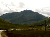 Laoigh from Glen Cononish
Located west of the small town of Tyndrum, Ben Lui (1130m/3703ft), is the most notable peak in the Glen Lochy region. The route via Glen Cononish is undoubtedly the best route of approach for this peak as the views towards the peak are very aesthetic and its this aspect that pulls you along the long track road.
Starting points are available in Tyndrum and also at a small parking place marked Dalrigh on the OS maps (about 2 miles before Tyndrum on the A82 road). Both points have well maintained track roads that eventually merge and lead to the foot of Ben Lui’s great Corrie Gaothaich.
The peak was at the forefront of Scottish winter climbing due to its locality and the draw of Coire Gaothaich holding snow well into the spring and has retained this attraction over the last hundred or so years.
Approx time taken: 6 to 8 hours.
Getting There
 Coire Gaothaich
 Beneath Coire Gaothaich
Car
From Glasgow take the A82 road ,via Loch Lomond, until reaching Crianlarich.
From Perth or Edinburgh take the A84 road on the outskirts of Stirling, via Callander, to Lochearnhead. Continue straight on as the road now becomes the A85 until reaching Crianlarich.
From Crianlarich, follow the A82 towards Tyndrum. Parking is available at Dalrigh(on the left) roughly 2 miles before Tyndrum or park at Tyndrum itself and head south towards the train station to the forestry track road.
Train
Glasgow Queen Street station direct to Tyndrum.
Scotrail info
Bus
A bus service runs daily from Buchanan Street bus station in Glasgow to Fort William, via Tyndrum.
Scottish City Link info
Route Description
Dalrigh to River CononishStarting at the parking bay at Dalrigh (NN344291), head west-south-west along the track passing by some houses on the left until joining the track for the West Highland Way (wooden posts marked in yellow denote this). Follow this, crossing a small bridge, until the marker post indicate a right turn, heading north, for the West Highland Way. At this point continue along the track in a west-south-west heading, passing under a small railway bridge, where the track then heads west towards the River Cononish and joins up with the track from Tyndrum (NNNN316287).
Tyndrum to River Cononish
Starting at the parking outside The Green Welly Stop in Tyndrum (NN329307), head south-east along the main road until reaching a small road just after the Tourist In formation centre. Follow this road all the way along until reaching Tyndrum Lower station. Carefully cross the railway track at the crossing point and follow the forest track road all the way until reaching the River Cononish and the track from Dalrigh.
River Cononish to Gully
Follow the track westwards along the northern banks of the River Cononish until reaching a fork just before the farm buildings, head west-south-west along the left hand track, through the gate and continue along this track until it ends beneath Coire Gaothaich (NNNN281274). Ford the Allt an Rund and follow the path past the old croft ruins. From here the path climbs steeply south-west on the northern side of the Allt Coire Gaothaich until gradually leaving it to reach the bottom of the Central Gully (NN271267).
 Route 8, Gully to ridge of Stob Garbh
 Stob Garbh's ridge
 Stob Garbh's ridge
 Looking down Central Gully
 Croft remains
 Lui over the River Cononish
Gully to ridge of Stob Garbh
There is a path that now heads west that leads to the ridge of Stob Garbh, it is a faint path where it begins and can be easily missed, however the section of the ridge on Stob Garbh is clear to see and you should have no problems regaining the path should you have overlooked it. The route onto the path is very steep and sections of the path are slightly eroded making the climb a bit slippery, although no real problems are encountered as it is nothing more than an easy scramble. Once you attain the ridge, follow the path south-south-west, where it narrows above the gully to your left. Continue onwards and upwards until reaching the summit cairn of the north-west top. From here follow the path south-east, that drops down a bit before climbing up again to reach the summit of Ben Lui. You should take care on this latter section as it is quite exposed to your left above the Central Gully.
Distance travelled - 9 Kilometers
Elevation Gain - 930m
Estimated ascent time - 4 hours
If you are fortunate enough to get views from the top then the rest of the Glen Lochy peaks, the Crainlarich Hills and Cruachan to the south west will be the ones to catch your eye.
Descend via the route taken on ascent.
Fancy seeing some large plane wreckage???
From the gully, make your way south-east onto the southern of Ben Lui’s two ridges, Ston an Tighe Aird. There is no path onto here so just pick the best way you can. Again this can be quite loose and slippery but, is nothing more than an easy scramble. Once onto the ridge (NN272265), a path heads south above Coire an T-Sneachda, then south-west all the way to the plane. Care should be taken when in the region of the plane as it is located in an area where it was deemed to dangerous to remove the wreckage.
Essential Gear
Summer conditions: Backpack, walking boots/trainers, hat, gloves, water, food, waterproofs(your in Scotland you can bet it is going to rain at some point), map, compass, first aid kit, penknife, spare socks and your camera.Winter conditions: All of the above and ice axe, crampons, helmet and rope.
Books & Maps
 Beinn Laoigh. Image reproduced with kind permission of Ordnance Survey and Ordnance Survey of Northern Ireland.
Books
The Southern Highlands by D.J.Bennet.
Scottish Hill and Mountain Names by Peter Drummond
The Munros by Cameron McNeish
The Munro Almanac by Cameron McNeish
Scottish Mountains on Ski by Malcolm Slesser
Southern Highlands (pocket mountains) by Nick Williams.
Maps
Harvey Superwalker Map: Crianlarich
OS Explorer Map sheet :
OS Landranger Map sheet: 50
External Links
Visit ScotlandDiscover Scotland
Undiscovered Scotland
Walk the Highlands
The Scottish Mountaineering Club
Munro Magic
Crianlarich & Tyndrum history
Tyndrum Tourist Info Contact
West Highland Way
Ben Lui Conservation
Buachaille.com