|
|
Route |
|---|---|
|
|
36.38265°N / 50.98960°E |
|
|
Mountaineering |
|
|
Summer |
|
|
A few days |
|
|
Mostly Hike, Some Class III |
|
|
Getting There
From the shelter on the west end of the town of Roodbarak, drive a dirt road to a place called Vandar Bon. You will find another shelter at this spot. The road continues a little more to end at an elevation of 2350 m. Total distance from Roodbarak shelter to the end of the road is 12 Km.Route Description
All distances are per my GPSPlace………..…Elevation (m)…….Distance (Km)
End of Road……2350……………..Zero
Keshti Sang ……2700………………2.6
Rock
Sarchal Shelter….3750………………3.4
Chaloon Pass…….4400……………...4.5
Chaloon Summit….4516……………..1
Total………………………………….11.5 Km
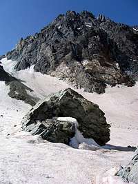
From the end of the road, follow a well-established and well-signed trail to Sarchal Shelter/Alam Kooh (ie follow the left branch and not the right branch which goes to Kaljaran Pass/Kalahoo. Signs are in Farsi and in English). As the trail goes up the slopes, it generally remains about 100 m above the stream at the bottom of the valley. At an elevation of 2700 m, the trail crosses the stream near a huge boulder named Kashti Sang (Ship Rock).
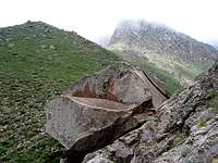 Keshti Sang
At around 3450 m, you will see a huge hill made of dirt and crushed rock. This is probably the terminal moraine of the valley glaciers. Continue up the trail to reach the 3750 m Sarchal Shelter.
From Sarchal Shelter, Alam Kooh (4850 m) and Siah Sang (4604 m) Peaks will be well-visible. Mian-Se-Chal (4348 m) Peak will appear as an inconspicuous point in front of and to the left of Alam Kooh. Two valleys will be seen in front of you to the south. The valley on the left is the one that you want to get into (valley of Alam Chal Glacier).
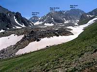 Valley on the left
Head south and follow the trail up a short segment of grassy slopes until the trail reaches the huge glacial debris field that covers the bottom of the valley. Pay attention to cairns and signs on the boulders to identify the trail. Look for a nameless 4450 m high point coming to view to the left (east) of the Siah Sang Peak. The 4400 m Chaloon Pass sits between Siah Sang and Point 4450 m.
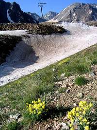 Chaloon Pass
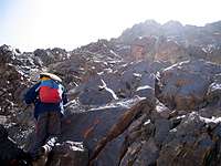
At an elevation of 4000 m, you will reach the eastern base of the Mian-Se-Chal Peak. The valley turns west here and the north wall of Alam Kooh Peak will come into full view on the south side of the Alam Chal Glacier.
 North Wall of Alam Kooh
Do not go west. Continue south toward the base of the Siah Sang Peak. The usual route goes up a steep slope to reach the Chaloon Pass. This slope remains snow bound well into mid summer and can be difficult to climb early in the season. We opted to avoid the snowy slope and do some Class III/IV climbing up the nearby rocky slopes that were snow free until we reached the top of Point 4450 m.