
-
 35824 Hits
-
 91.06% Score
-
 34 Votes
|
|
Mountain/Rock |
|---|---|
|
|
37.84514°N / 107.98421°W |
|
|
13913 ft / 4241 m |
|
|
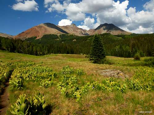
Overview

Sunrise on Gladstone Peak

Gladstone from Wilson Peak

Gladstone and Wilson Peaks

Sunset over the Wilson group

Gladstone Peak from Mt. Wilson

Gladstone Peak E face

Gladstone Peak from Mt. Wilson
Gladstone Peak from Mt. Wilson

Gladstone from Navajo Lake
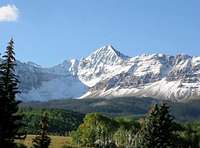
Gladstone Peak is ranked number 67 of the Colorado Centennials and is part of the San Miguel Mountains located in the Lizard Head Wilderness and sits halfway in both Uncompahgre National Forest and San Juan National Forest. It is connected to two fourteeners (Wilson Peak and Mount Wilson) by loose rocky ridges. El Diente is another 14er that is close by.
Gladstone Peak presents an impressive view from the saddle at the head of Silver Pick Basin and is also the dominant feature at the head of the Navajo Basin when approaching from the west. Gladstone Peak is often overlooked and therefore less crowded than the nearby 14ers. The peak itself reaches a height of 13,913 feet so it doesn't quite make the 14,000-foot cut but many will say this is a good thing.
This Peak is not to be taken lightly, as it has been known for its loose rock requiring 3rd class climbing to ascend. To climb this mountain you should have experience in loose terrain. Use the Trails Illustrated Map #141: Telluride-Silverton-Ouray-Lake City and/or one of the USGS Maps including the Mt. Wilson, Dolores Peak, and Little Cone Quads for this area.
  |
 Gladstone Peak Gladstone Peak |
 Gladstone Peak Gladstone Peak |
Getting There
The Rock of Ages trailhead has now become the standard place to start a climb of Gladstone peak, as well as the other nearby 14ers in the Wilson group. First drive to Telluride where the lase services are located.
From Telluride, drive on Colorado 145 heading west from Telluride for 9 miles and turn left (south) at the signed Silver Pick Road and measure from this point. Drive 4 miles south to a junction and turn right up the hill following signs for the Rock of Ages trailhead. Cross to the east side of the creek after 4.3 miles and continue to a fork in the road with a large open area to stage horses at mile 5.6. Stay to the right at this fork following the signs. Do not head left here as this is the private road. Continue up the nice road as it climbs through two switchbacks and reaches the new Rock of Ages trailhead with ample parking at mile 8 with an elevation of 10,380 feet. This is the end of the road.
Another good starting point is the Navajo Lake Trailhead which is lower at 9,340 feet but avoids the up and down of the Rock of Ages saddle. From Lizard Head Pass n CO 145, continue south for 5.4 miles and turn right (west) onto Dunton Road (FS 535). Measure from this point. Begin climbing up through two long switchbacks and stay straight at mile 4.2 and descend slightly to the West Dolores River. The road makes a very hard left turn to the south at mile 7.2 and you reach the well-marked trailhead at mile 7.3 with ample parking. This road is good for passenger cars.
Check the road conditions here.
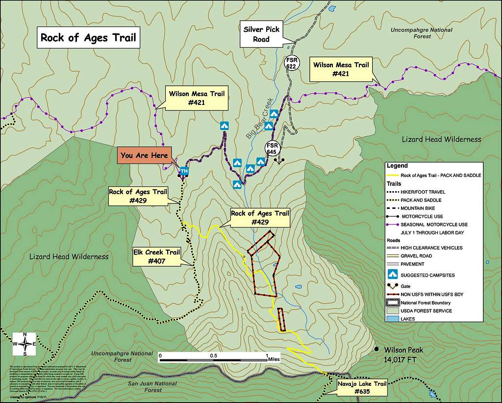
Current Access Map
Below is the map the USFS made to show where the private property is and the Rock of Ages Trail you must take to avoid it.
|
Approaches
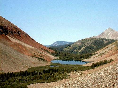
 Gladstone Peak from Navajo Lake in spring
 Gladstone Peak from Upper Navajo basin
 Gladstone Peak at first light
 Sunrise on Gladstone Peak
 Navajo Basin
 Navajo Lake reflection
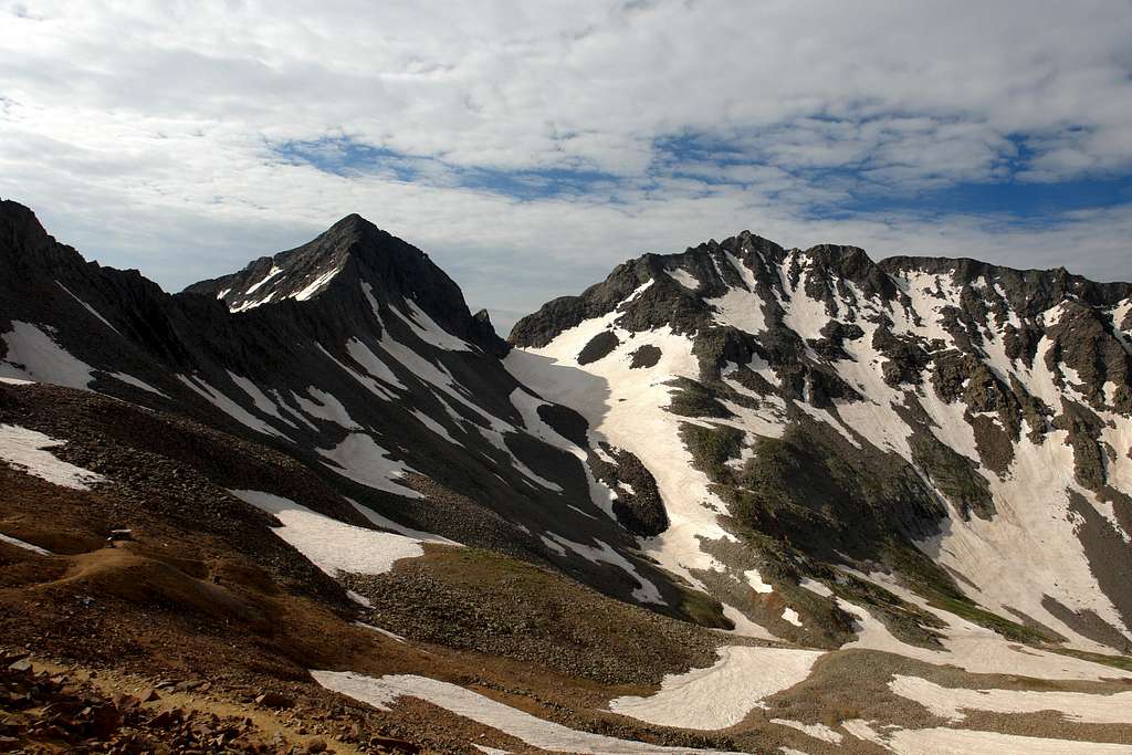
The Rock of Ages trail is the standard approach. From the Rock of Ages trailhead, start hiking south on the Rock of Ages trail #429 and reach a junction after about 0.6 miles. Turn left here to stay on the Rock of Ages Trail (if you go straight you will follow the Elk Creek trail #407). Continue through the forest until you reach the first views in a rocky basin above and east of Elk Creek.
The trail will switchback up the large talus slope to the east on an old road. You may find old cables and other mining junk here. Eventually, you will reach the crest of the ridge separating the Elk Creek basin with the Silver Pick Basin. The trail crosses the ridge then contours above the private property in Silver Pick Basin. Once you are high above treeline in Silver Pick Basin, follow the trail as it switchbacks up to the 13,050 foot Rock of Ages Saddle about 4 miles from the trailhead.
RT Distance from TH - 8 miles
RT Elevation Gain from TH - 3,000 feet
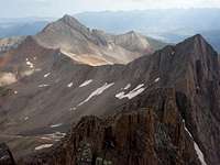
 Point 13,123 from ROA Trail Point 13,123 from ROA Trail |
 Gladstone from ROA Saddle Gladstone from ROA Saddle |
The Navajo Lake approach is longer but generally regarded as a more scenic and enjoyable hike. From the Navajo Lake trailhead, hike the trail following Navajo Creek for 5 miles to 11,150 foot Navajo Lake with great campsites in the trees around the lake. Hike around the north side of the lake for 0.2 miles and continue another mile to the upper Navajo Basin at 12,100 feet where great camping can be found on flat benches. There is usually a small meltwater tarn at around 12,200 where you can get water. This spot lies right at the base of the north face of El Diente Peak. From here another 0.8-mile walk to the east gets you to the base of the final 300 foot climb to the 13,140-foot low saddle on the north ridge of Gladstone Peak.
RT Distance from TH - 14 miles
RT Elevation Gain from TH - 3,500 feet
 El Diente from Navajo Lake trail El Diente from Navajo Lake trail |
 Navajo Lake Navajo Lake |
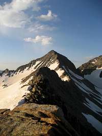
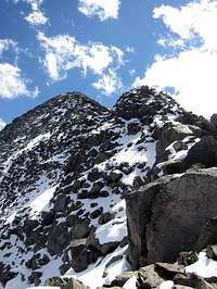
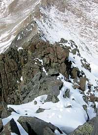
Standard Route - North Ridge Class 3
 Gladstone Peak North Ridge
 Gladstone Peak North Ridge
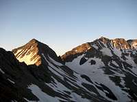 Gladstone Peak and Mt. Wilson
 Gladstone Peak from Mt. Wilson
 Looking down the N ridge
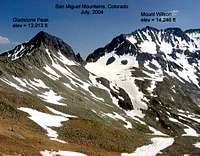 Gladstone Peak Overview
The standard climbing route is the north ridge. If you use the Rock of Ages approach, descend on the trail to a small mining cabin at 12,800 feet that is in need of a serious face-lift. Leave the trail and traverse around the basin on talus at or near the 12,800-foot contour for 0.4 miles. Pass below the low saddle in the ridge and ascend 300 feet up one of several loose gullies to the crest of the north ridge just south of the saddle. These gullies are the worst part of the climb as you'll likely be doing the "take one step slide one step" climbing technique.
If you use the Navajo Lake approach, from the 12,100-foot tarn, continue up the valley in an east, and very slightly north, direction for 0.7 miles and ascend one of the same 300-foot gullies to the north ridge just south of the low saddle.
Once on the north ridge, scramble south for 0.4 miles up and over relatively stable blocks. Drop just off to the left (east) side of the ridge to avoid more difficult blocks. Do not stray too far from the crest however as this will get you into some much looser more dangerous terrain. Upon reaching the summit you command a view of Mount Wilson few people get the chance to see.
 |
 |
 |
Map
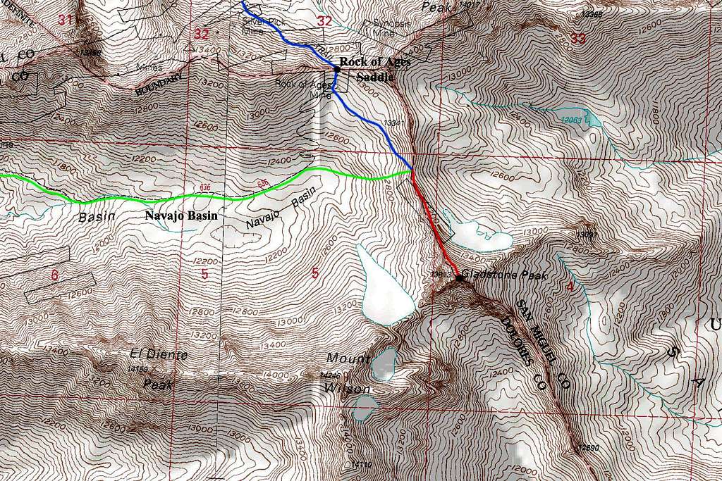
BLUE: Rock of Ages Saddle Approach
GREEN: Navajo Basin Approach
RED: Gladstone Peak North Ridge Route - Class 3
When To Climb
June through September is the best time to make the climb, but the snowfall from the year before determines the accessibility. Snow is possible at any time of year, so be prepared. Winter climbs are possible but only recommended for experienced climbers with the required gear.
Climbing Periods:
October-May: Expect high snow levels and high wind in places. Snow can fall at any time without warning. You shouldn't attempt a mountain at this time if you are not an experienced climber. Even then, you shouldn't attempt the mountain if you are not familiar with the area. Avalanches occur with high frequency in various places and are the single biggest killer in the Colorado winters. Be sure to know where these places are and avoid them if possible. January through March will be the coldest and windiest time with the avalanche dangers peaking in March.
June: This is a transitional period between spring and summer. Snow levels start to fall quickly in June, but in the Rockies, snow levels can still be quite high in June and often are. One of the best reasons to go in June is because it is before the monsoon season in which there is a regular occurrence of lightning storms and this is also the prime time for spring snow climbing. Snow couloirs and slopes have firmed up and allow for fun climbing. Freezing temperatures however still occur regularly at this time.
July-August: This is the peak of the climbing season in Colorado although it occurs at the same time as the monsoons. In a normal year, lightning storms occur regularly at around noon. Do not attempt to climb the peak during a storm. Unfortunately, this time also is the peak fire season and often thick smoke can fog many places in Colorado, obstructing views and making it hard to breathe.
September: This is the other transition period for the mountains where summer transitions into fall/winter. At this time, the aspens change color and the first snows begin to fall. Cold temperatures begin to occur regularly again and by mid-October, snow becomes permanent. This is hands down, the best time to climb a Colorado Peak. The air becomes crisp and clear and the mountains are so colorful. Some of my best and most vivid memories in the mountains come from September in the Colorado Rockies.
This is a frequent avalanche slide area. Check here for an avalanche forecast
Mountain Conditions
 View of Lizard Head
To avoid the regular occurrence of thunderstorms on the mountain you should plan to climb the peak in the morning, getting to the summit around 10:00 AM. After 11:30 the weather can change very quickly. The air is very thin in the mountains and people unaccustomed to high altitude can get altitude sickness. If you begin to feel dizzy, slow down, and relax. If you start getting a serious headache, consider turning around and descending.
Check with Uncompaghre National Forest
Address: USDA Forest Service2250 - Highway 50Delta, CO - 81416
Phone: (970) 874-6600
Check here for information on snow precipitation.
Red Tape
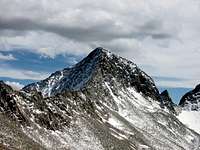
 Wilson Peak
No fees or permits are required. The peak, however, lies in Lizard Head Wilderness. Wilderness areas deserve the utmost care, please respect the environment in the area. All it takes for fees to be instated is for someone to screw up by leaving a bunch of trash on the mountain. In places such as California, it costs $5 dollars just to park in the National Forest.
Please respect the environment, and the rest of us won't have to pay any fees. "Leave No Trace" is the main policy of the wilderness area. The "Leave No Trace" Regulations are as follows: Plan Ahead and Prepare Travel and Camp on Durable Surfaces Dispose of Waste Properly Leave What You Find Minimize Campfire Impacts Respect Wildlife Be Considerate of Other Visitors
External Links
 Gladstone Sunset
Gerry Roach's "Colorado Thirteeners" Book has very detailed descriptions for Gladstone Peak since it is one of the Centennials.
14ers Trip Report for the N Ridge