
-
 36624 Hits
-
 86.11% Score
-
 22 Votes
|
|
Mountain/Rock |
|---|---|
|
|
28.26205°N / 16.66935°W |
|
|
Hiking, Mountaineering |
|
|
Spring, Summer, Fall |
|
|
10282 ft / 3134 m |
|
|
The Islas Canarias
 El Hierro and La Gomera hovering above Pico Viejo El Hierro and La Gomera hovering above Pico Viejo |
Europe or Africa?
The Islas Canarias (or Canary Islands) are group of islands of volcanic origin located to the west of Africa near the Moroccan coast. They belong to Spain and thus are – from a political point of view – a part of Europe. Inhabitants therefore consider themselves European even though on a clear day the African coast can be clearly seen from the highpoints of the eastern islands and geographically they belong to Africa.
There are seven islands, which are politically separated into two regions. The eastern islands, Lanzarote, Gran Canaria and Fuerteventura have their administration in the Gran Canarian Capital of Las Palmas whereas the four western islands Tenerife, La Palma, La Gomera and El Hierro are “ruled” from Santa Cruz de Tenerife.
As for geography and geology there also is a drift from east to west: the oldest islands – with 25 million years of age are the eastern islands of Lanzarote and Fuerteventura. Tenerife and Gran Canaria are about 10 million years old while the small western islands El Hierro, La Gomera and La Palma are the youngest with about 2 – 5 million years of age. All but the two eastern islands are mountainous with mighty Pico Teide (3718m) on Tenerife the highest mountain of all Spain. If you consider that the straits between the islands are among the deepest waterways of the world (with down to 3500m) the whole scope of the Canarian architecture becomes apparent.
|


Overview
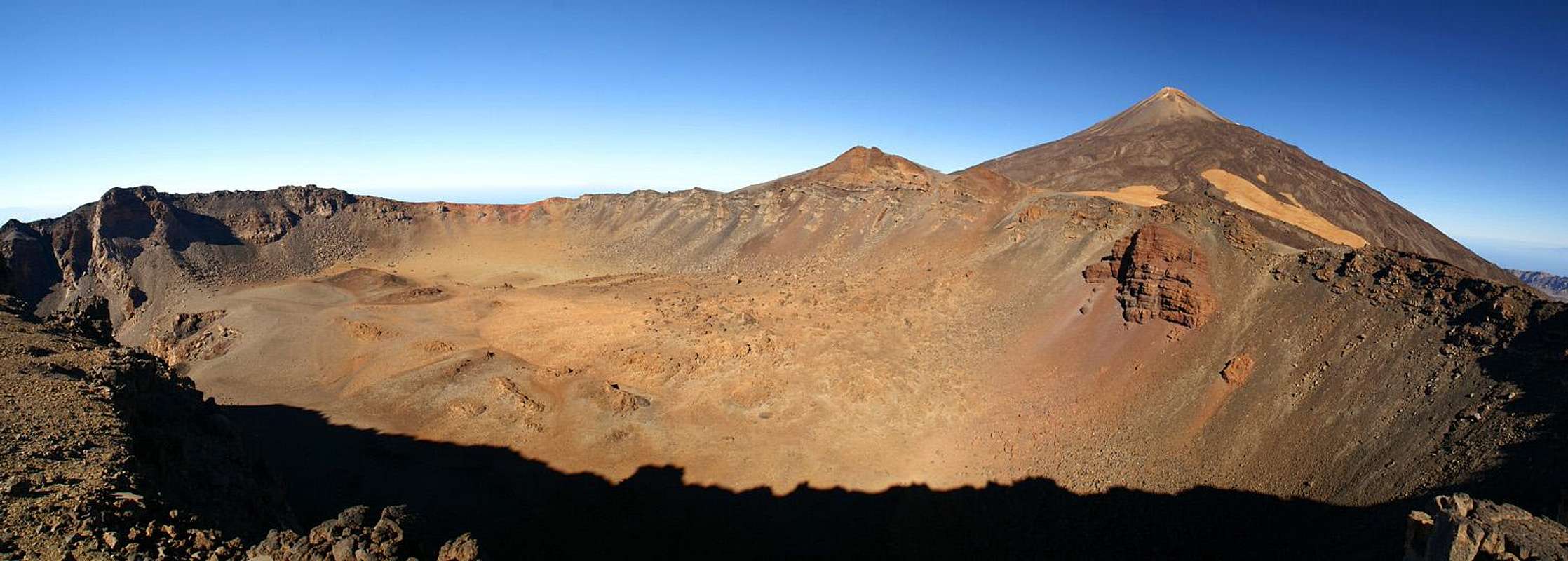  |
Pico Viejo – the old peak – is the second highest mountain of Tenerife and thus of all the Islas Canarias. It would probably not qualify as a separate mountain by UIAA standards since it is “only” an outpost on the mighty bulk of Teide. Still it is an impressive sight and on most listings of Spanish mountain it finds its proper place.
As the name indicates, Pico Viejo is one of the old craters of Teide. You might well say it is (still) the main crater since its enormous size surpasses everything you will find on Tenerife Island. The diameter of the crater is about 1km, while its depth surpasses 250m. Like is true for most of the volcanic craters on the Canarias, Pico Viejo has two summits, the higher eastern one at 3134m and the slightly lower western one at 2995m. The crater colours are incredible: all shades of red with tints of yellow here and there.
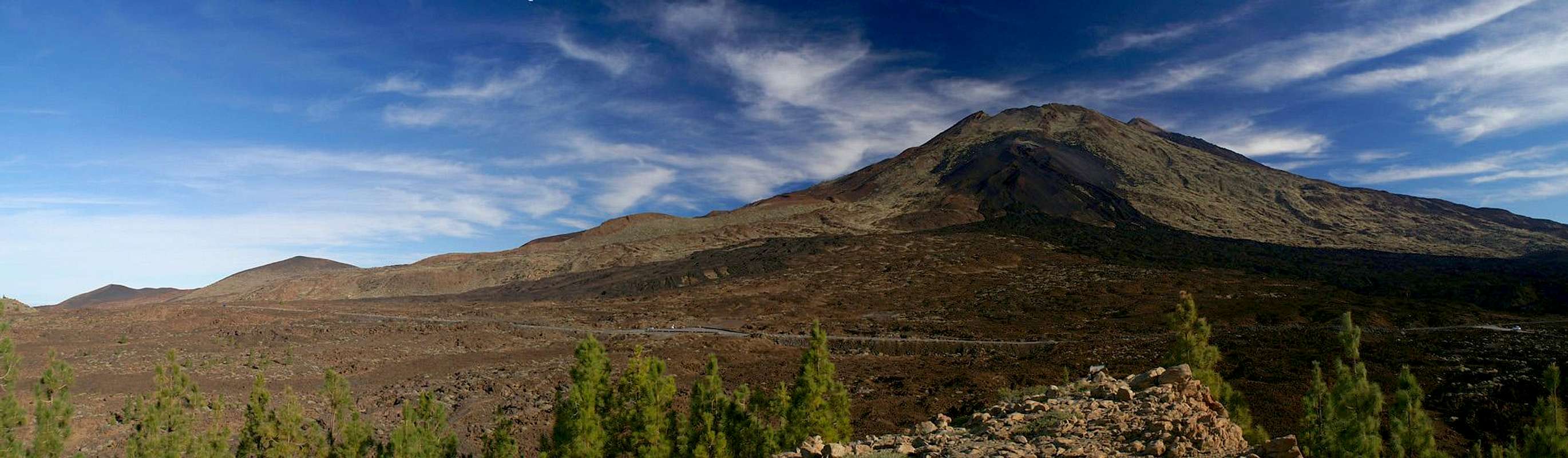
Speaking of craters – the last eruption on Tenerife took place in 1798 on the western flanks of Pico Viejo on the craters of the Narices del Teide (the nostrils of Teide). The Lava flows can still be beautifully seen from Montaña del Cedro to the west of Pico Viejo, which in any case is the best spot to take in Pico Viejo’s impressive bulk. During the 1798 eruption more than 12 million cubic meters of volcanic material were produced out or the Narices del Teide craters.
There are two routes to Pico Viejo, but both are a very strenuous undertaking:
- up to about 2001 the easiest route was to take the cable car to Teide and down hike to Pico Viejo. This option has become a long day tour since the day the cable cars were closed to the public. Now this route means an ascent to Spain’s largest mountain (you need at least get to Rambleta, the 3500m plateau below Teide’s summit Pan de Acuzar) before you can enjoy the scree ride down to Pico Viejo.
- the second route – starting at Bocca Tauce is a 1000m ascent, the half of which climbs the “scree fields from hell” – a steep path less scramble along the sand-like cinder scree of Pico Viejo.
Additionally an elevation of 3000+m on an island in the trade wind zone almost ensures very high winds on the top of the exposed summit. Take into account that the temperature difference will be severe. I have seen reports of travel groups almost being blown from the summit!
Together the lack of easy routes and the weather ensure that Pico Vejo is not what you would call a popular peak. You won’t be lonesome on the summit but there won’t be crowds. On our climb in May 2001 we only met another pair of hikers while on our scree ride down the western slopes of the mountain. The views however are breathtaking: Teide from up close, La Gomera and La Palma across the sea and the best viewpoint for overlooking the Cañadas del Teide, Tenerife’s large erosion crater.
|


Getting There
 |
As one of the major European vacation getaways Tenerife can be reached from all major European airports. From Spain there are regular flights from the rest of Europe you can book lots of charter flights. On Tenerife there are two international airports, one at Santa Cruz in the east, one at Los Abrigos in the south.
You can reach the Cañadas del Teide from all four directions. Just drive as far upwards as you can and you'll be there.
- From the south there is a road from the airport via Villaflor to the Cañadas.
- From the West you must head for Chio either from Playa de las Americas or from Santiago del Teide.
- The northern road starts from Puerto de la Cruz
- The eastern ascent starts from the capital Santa Cruz del Tenerife and crosses the mountain range Cumbre Dorsal.
Alternatively you can take the bus either from Playa de las Americas (Line 342) or from Puerto de la Cruz (Line 348). Both buses depart at about 9:00 a.m., the return buses go around 4:00 p.m.
The reasonable trailhead for Pico Viejo is at Bocca Tauce, the south western corner of the Teide National Park. There is ample parking space and a bus stop.
Red Tape
 |
Pico Viejo is located in the "Parque Nacional del Teide" which is composed of a giant volcanic crater the "Cañadas del Teide" with 48km circumference. In fact the Cañadas were created by two craters which over the time (and due to erosion) blended into each other. The central range of the Roques Garcia formed the boundary between these craters and you can still see how the earth was tormented to form these bizarre rocks. To the south and west the crater walls of the Cañadas del Teide are still standing. They form a number of distinctive summits, the highest of which is Guajara at 2715m. The northern and most of the eastern crater walls have disappeared below the huge Pico Teide and Pico Viejo volcanoes.
Activities in the national park are limited as in every park. You are requested not to leave the trails - and from your own judgement - you shouldn't. The lava sometimes piles up to heights of 5 - 10m and makes orientation VERY difficult. Climbing is only allowed at the base of Guajara at the Piedras Amarillas and at Roques de Garcia.
When To Climb
Climbing is possible all year round on all islands of the Islas Canarias. Usually there are only a few days in which you can expect snow on the Cañadas, mostly on the top of Teide. In February 2005 however the whole upper part of Tenerife was covered with a thick layer of snow, down to Llano de Ucanca at 1900m. Climbing Pico Viejo would have been possible with crampons only at that time. Which - in case you brought them - would have facilated the ascent along the scree fields of hell a lot!If you have a look at the Teide page you will see that Rifugio Altavista, which is located at roughly the same elevation as Pico Viejo was covered in snow up to its roof.
Accommodation
Of course you can find a lot of hotels, fincas and casas on the island which you can book from any travel office. The Cañadas del Teide are a natural park so there is no camping allowed. You might use the Parador Hotel in the park centre which is supposed to be quite expensive, however. Better stay at one of the hotels at sea level and drive up by rental car or bus. Beware of altitude sickness in that case. Do the slow hike!Weather Conditions
There are several sites on the web which give you information on the weather on Tenerife. However, they all show the weather for the coastal regions (Puerto de la Cruz) which significantly differs from the weather in the Cañadas del Teide which are 2000m of elevation higher. The following table shows data for Puerto de la Cruz on the coast.| Month | Jan | Feb | Mar | Apr | May | Jun | Jul | Aug | Sep | Oct | Nov | Dec |
| Avg. day temp.[°C / °F] | 19 / 66 | 19 / 66 | 20 / 68 | 21 / 70 | 22 / 72 | 23 / 73 | 24 / 75 | 26 / 79 | 26 / 79 | 24 / 75 | 22 / 72 | 20 / 68 |
| Avg. night temp.[°C / °F] | 13 / 55 | 13 / 55 | 14 / 57 | 14 / 57 | 16 / 61 | 18 / 64 | 19 / 66 | 20 / 68 | 20 / 68 | 18 / 64 | 17 / 63 | 14 / 57 |
| Water temp.[°C / °F] | 19 / 66 | 19 / 66 | 19 / 66 | 19 / 66 | 20 / 68 | 20 / 68 | 22 / 72 | 23 / 73 | 22 / 72 | 22 / 72 | 21 / 70 | 20 / 68 |
| Rainy days | 10 | 7 | 8 | 4 | 3 | 2 | 1 | 1 | 3 | 5 | 7 | 9 |
The Canarian Islands (as well as Madeira) are located in the trade wind zone. You almost always encounter northeastern winds which carry a lot of humid air. Being forced to climb to higher altitudes this moisture condenses into clouds. This in return means that most of the time the northeastern part of the islands is covered in clouds from altitudes of 1000m through 2000m.
The mountains themselves - being mostly of the same altitude -finally stop the clouds so that on their southeastern slopes the clouds "run out". In the case of Tenerife the Cañadas del Teide are so high that rarely ever do you encounter fog or clouds. This on the other hand means that the whole area is very dry so be sure to bring your own water.
The southern part of Tenrife rarely gets any rain which is why most of the beaches have been established there. The best hikes on the Island are in the Cañadas or in the northwestern (Teno mountains) or eastern (Anaga Mountains) part.
Maps 'n' Books
Out of the Multitude of maps and books I have been using the following:- Maps
- Teneriffa
Kompass Map WK233
Kompass Verlag
ISBN: 3-85491-038-X
Books
- Teneriffa, Tenerife
K.Wolfsperger, C. Ade
Rother Walking Guide
Rother Verlag
English - ISBN: 3-7633-4809-3
German - ISBN: 3-7633-4016-5