
-
 54625 Hits
-
 93.58% Score
-
 43 Votes
|
|
Mountain/Rock |
|---|---|
|
|
39.18570°N / 106.185°W |
|
|
13898 ft / 4236 m |
|
|
Overview
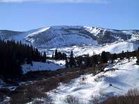
Horseshoe Mountain

Horseshoe Mountain
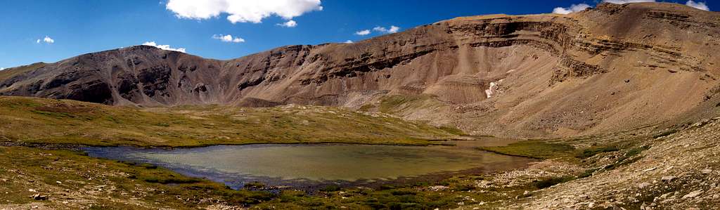
Horseshoe Mountain is one of Colorado's highest peak ranked at number 72 with 758 feet of prominence. For many peak baggers, that's reason enough, and it sees frequent ascents however for those less inclined to play the numbers game, Horseshoe is a worthy goal because of its ease of access, the views it affords, and its magnificent glacial cirque.
Seen from the west, Horseshoe is merely a bump on the ridge that is the Mosquito Range, barely distinguishable from its neighbors. From the east, Horseshoe takes on a new character and becomes the peak by which all of its neighbors are defined. The namesake cirque on Horseshoe's east side is a beacon from much of the South Park area and is most likely the outstanding geographical feature of the Mosquito Range.
Horseshoe is usually climbed from the east side via a series of old mining roads originating from the Leavick site located southwest of Fairplay. Hikers heading up Mount Sherman will be familiar with this trailhead. Other routes are possible on this gentle mountain. A ridge run north from Weston Pass looks to be a sure winner and there are several lines through the cirque itself that are fantastic on spring snow.
  |
Getting There

Fourmile Sunset

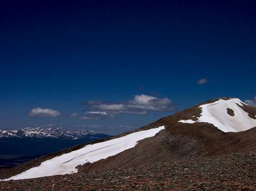
Peerless from Horseshoe

Horseshoe Mountain

Skiing Horseshoe Basin
Gold Basin Trailhead
Horseshoe Mountain, like most of the Mosquito Range peaks can be accessed either from the east or the west. If you approach from the west side you will use the Gold Basin Trailhead. From the center of Leadville on Highway 24 continue south for 7.5 miles to Lake County Road 7 with signs for Weston Pass. If you are coming from Buena Vista this junction is 7.2 miles north of the US 24 and Colorado 82 junction. Turn east onto Lake County 7 towards Weston Pass for 7.5 miles to the trailhead. Park passenger cars on the south side of the road just to the east of a rough side road that heads north into Gold Basin. If you have a high clearance 4WD vehicle you can continue an additional 1.1 miles up this steep road as it switchbacks under power-lines to its end in Gold Basin atop an unnamed mound at 11,660 feet. Another option would be to continue 3.5 more miles east on the Weston Pass Road to the summit of Weston Pass where you can park. Be weary however that passenger car cannot descend the east side of this pass as the road is considerably rougher on this side.
Iowa Gulch Trailhead
Another trailhead you can use for Horseshoe Mountain if approaching from the west is the Iowa Gulch Trailhead which is the same for Mount Sherman. Measuring from the junction of Highway 24 and East Third Street in downtown Leadville, head east onto East Third Street for 0.3 mile to South Toledo Street and turn right (south) onto this road. Continue on this paved road which is also called Lake County Road 2. At mile 4 on this road, pass an active mining operation which also marks the winter closure. Reach the trailhead at mile 6.3 with an elevation of 11,840. This road is passable to any car.
Fourmile Creek Trailhead
This is the standard trailhead for Horseshoe Mountain which approaches from the east side of the range. From the junction of US 285 and Colorado Highway 9 in Fairplay, continue south on US 285 to Park County Road 18 and turn right (west) onto this paved road and measure from this point. Enter the Pike National Forest at mile 4 and pass the Fourmile Campground at mile 8. Continue another 2.5 miles to the Leavick Townsite marked by a few old buildings along the north side of the road. Park passenger cars here however if you have a high clearance 4WD vehicle continue on the rougher road another 0.9 mile to 11,580 feet at the intersection of another old blocked off road.
Route Options
The route you climb is solely dependent on which trailhead you decide to start at. Most routes on Horseshoe Mountain are only Class 2 but there are some nice snow routes up the infamous Horseshoe Basin.
RT Distance - 9.4 miles
RT Elevation Gain - 2,600 feet
This is the standard route on the mountain. From the Fourmile Creek trailhead continue 0.9 mile up the road to the old blocked road. Continue left (south) on this road and reach the crest of the broad east ridge of Peerless Mountain and follow it as it rounds into Horseshoe Basin. The infamous Horseshoe Cirque is easily seen to the southwest. Leave the road near its end at the old Peerless Mine at 13,100 feet. Reach the crest of the Northeast Ridge and follow its easy gentle slopes around the top of Horseshoe Cirque to the summit.
 NE Ridge Winter NE Ridge Winter |
 NE Slopes NE Slopes |
 Near Fourmile TH Near Fourmile TH |
 Mining shed near summit Mining shed near summit |
 Hiking the old road to Horseshoe Mountain
RT Distance - 5.8 miles
RT Elevation Gain - 3,100 feet
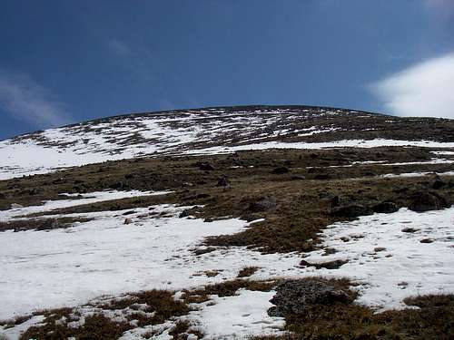
Starting at the Gold Basin Trailhead, hike or drive the 4WD road 1.1 miles to its end. Continue north and descend slightly while going around the private property just to the east. Locate some old tracks and follow them through trees. Upon reaching treeline, climb straight up the west slopes of Horseshoe Mountain on grass and talus for 1 mile and reach the crest of the range just south of the highest point. Walk north a few steps to the summit. Views to the west of the two highest peaks in Colorado are fantastic the whole way up.
 Hiking up the west slopes
South Ridge - Class 2
RT Distance - 9 miles
RT Elevation Gain - 3,200 feet
This route is a fun ridge run with fantastic views in all directions. The entire route is above treeline. Starting from the Weston Pass Trailhead (See Gold Basin Trailhead), walk northeast on the ridge for just over a half mile to an unnamed point just west of Weston Peak, then continue on the gentle ridge crest for an additional 3.5 miles to Horseshoe Peak heading over un-ranked Ptarmigan Peak en-route.
 Hiking the gentle south ridge
Boudoir Couloir - Class 2 Moderate Snow
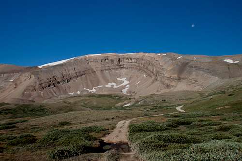
This is likely the best mountaineering route in all the Mosquito Range. Starting from the Fourmile Creek Trailhead, this climb starts out the same as the standard route but just as you round the broad east ridge of Peerless Mountain leave the old mining road and make a beeline for Leavick Tarn which sits right in the middle of the fabulous cirque. Begin climbing up easy snow at first and aim for the northeast facing couloir. This route tends to melt early so be weary. Climb the couloir which is about 40 degrees at the steepest and makes a great beginner snow climb.
 Boudoir Couloir Boudoir Couloir |
 Skiing Boudoir Skiing Boudoir |
 Climbing Boudoir Climbing Boudoir |
 Horseshoe Cirque Horseshoe Cirque |
 Boudoir Couloir Map
When To Climb/Red Tape
Horseshoe Mountain is climbed year-round, but optimal conditions generally occur from late June through September. Be aware that this also the season for afternoon thunderstorms in the Colorado mountains. Hikers should plan to be on the way down by noon. Although the area is pretty gentle, if you venture here in winter, be sure to have avalanche knowledge, a beacon, shovel and a probe. This area would be great for beginning skiers or boarders to get a first taste about backcountry travel. This peak lies within a heavily mined area on National Forest land. In the winter this area is a popular snowmobile area and 4-wheelers roam the area freely in summer. Red tape is as non-existent as it gets here!
Camping
Click here for information on established campgrounds in the South Park Ranger District. The Fourmile and Horseshoe campgrounds are convenient to the Fourmile Creek trailhead. You can also camp at any of the above mentioned trailheads. Leavick Tarn can make a nice overnight camp for a short backpacking trip if you have small children. The entire Horseshoe Bowl surrounds you from here and offers a spectacular place to relax.
 Horseshoe Bowl from Leavick
Maps
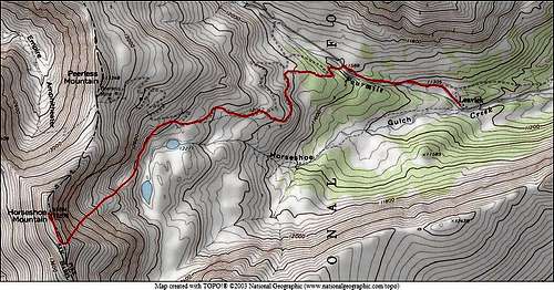
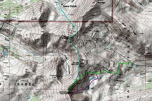
Below are a couple of maps showing the routes on Horseshoe Mountain:
 Horseshoe Mountain North Map Horseshoe Mountain North Map |
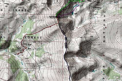 Horseshoe Mountain South Map Horseshoe Mountain South Map |
Geology
So what exactly am I looking at in this area?
The rocks seen in the Mosquito Range, especially from Mount Sherman and southward, are part of the Precambrian basement core that was uplifted during the Laramide Orogeny 65 million years ago. The rock types are mainly gneiss and granite with pegmatite intrusions. Believe it or not, the Sawatch Range and the Mosquito Range were all one big uplift of rock that resembled a massive dome structure. The two mountain ranged are actually the flanks of an enormous anticline. Remnant sedimentary rocks found on the eastern flanks of the Mosquito Range such as the Cambrian aged Sawatch Quartz arenite, the Ordovician aged Manitou Limestone. These two formations mark the first marine depositional environment in the rock record. This means that during the Ordovician period (480 million years ago) the land that Colorado is currently on was under water. Subsequent depositional periods later deposited the Dyer Dolomite and Leadville Limestone. These sedimentary rocks dip slightly to the east, dropping into and below the large, sediment filled South Park valley where Fairplay sits today.
So what happened to the massive dome between the two mountain ranges? Why is there a giant valley there today?
The answer to this has to do with more recent geologic activity. Keep in mind that the oldest rocks in the area surrounding Horseshoe Mountain are the are the Precambrian basement rocks which are overlain by the sedimentary rocks which are easily seen in the cliffs of Horseshoe Cirque. The Laramide Orogeny caused widespread uplift throughout much of the western half of the country, which is what created the Sawatch and Mosquito Mountains. About 30 million years later, around 30-35 million years ago another key event shaped this area. This was the Rio Grande Rift which is the same event responsible for forming the San Luis Valley. The massive dome that should connect the Sawatch and Mosquito Ranges was pulled apart during a rift event similar to the East African Rift happening today. For some reason that isn't yet fully known the western half of North America underwent massive tension despite millions of years of compression prior, which resulted in the crust of the earth to pull apart. This is very evident in Nevada with the hundreds of small mountain ranges with deep valleys between them all. Normal faulting resulted due to the tension and a large valley opened up between the Sawatch flank and the Mosquito flank of the anticline. Over time, the valley began to fill with sediment which washed down from the mountains to the east and west filling in the valley...similar to the was the San Luis Valley has been filled in. Thousands of feet of sediment fill these rift valleys. Today the valley between the two ranges makes a great path for a major river...The Arkansas River. The rifting ceased and the crust became pretty stable in all of the inter-mountain west 20 million years ago but only after a massive volcanism event in the San Juans which deposited some of the youngest rocks in the state however this event had a smaller effect on this area of Colorado.
So why did this area have such a rich mining history?
This is largely for two primary reasons. The main reason that this mountain chain is so rife with mined precious metals is because it sits on the east flank of the Rio Grande Rift and over top of the Colorado Mineral Belt. Interestingly, the Gore Range to the north which formed from nearly identical geologic processes is not as mineralogically rich because it doesn't sit atop the Colorado Mineral Belt, and thus has not received the mining that the Tenmile and Mosquito Ranges did. The Mosquito Fault is a major north-south normal fault that formed during the onset of the Rio Grande Rift and parallels the western flank of the Mosquito Range. Miners usually always dig where faults are located, especially major ones, because they provide great paths for water to flow through the rocks. When water flows through the rock, it alters it and changes the mineral makeup of the rock. It just so happens that some of the more valuable or desired minerals are the byproduct of altered rocks especially if they are concentrated which flowing water has a tendency to do. Certain minerals or elements become dissolved in the water and if a slight change in temperature, pH, or pressure occurs (which always will if the water is flowing), these minerals will drop out of the water all at once and become concentrated and usually be deposited within the faults. Hence why miners dig where faults are located and this area has a whole lot of faults. Also, since much of the basement rocks in the area have trace amounts of gold, silver and other valuable elements already in the rock, when they become concentrated from the process described above, it wasn't that uncommon for lucky strikes to be found. The second primary reason for the rich mining history is likely the accessibility. The Mosquito Range is a long, narrow mountain range that is very gentle. Roads were easy to make and travel on foot was unobstructed. This allowed miners to search every inch of land they desired. This rich mining history has made for very accessible mountaineering and hiking today and also provides a great place for 4-wheel and snowmobile enthusiasts.
Summit Views
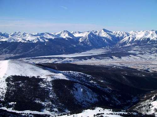 View west towards Sawatch Range View west towards Sawatch Range |
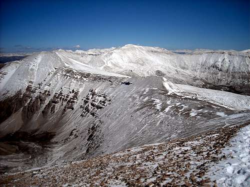 View north towards Mount Sherman View north towards Mount Sherman |