
-
 65924 Hits
-
 95.01% Score
-
 50 Votes
|
|
Area/Range |
|---|---|
|
|
46.64330°N / 12.33120°E |
|
|
10341 ft / 3152 m |
|
|
Feel free to add info
HaunoldHochebenkofelGsellknotenDreifingerspitzeWeißlahnspitzeSchusterplatteLanglahnspitzeMorgenalpenspitzeToblinger KnotenBurgstallPraterTorre PelegriniRotwandElferkofelNeunerArzalpenkopfArzalpenturmHochbrunner SchneidMonte GiralbaCima BagniCima d'AmbataCroda di LigontoPunta AnnaSorapissCroda di Tacco/Cima PadolaAntelaoCroda da CampoCorno CiapelelMonte Aiarnola
 |
 |
 |
 |
When I decided to do the Sexten Dolomites / Dolomiti di Sesto Group Page I didn't know what was awaiting me. A first glance at the Guidebook of the German Alpine Club told me that here a major piece work needed to be done. Therefore this page will be “under construction” for quite some time.
Please feel free to include comments, info, pictures, routes, whatever. This page – similar to the effort we have made on the Pale di San Martino Group – will need a lot of cooperation. Simply the task of subdividing the group in several subgroups will lead to discussions and arguments. I will follow the recommendations by the German Alpine Club as given in their guidebook (see the “Maps ‘n’ Books” Section below) but will deviate in some places.
 |
 |
 |
 |
 |
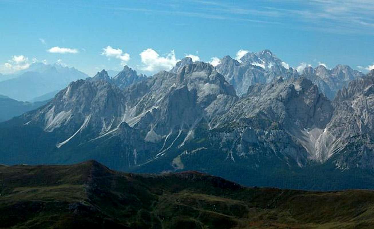
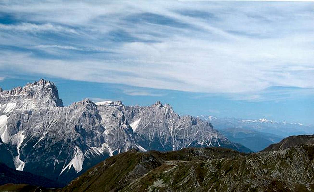
Overview – The Multiple Fascination with Sexten’s Dolomites
Rarely anybody who has been to the region hasn’t come away fascinated by the peaks, pinnacles spires and towers of the Sexten Dolomites. They form a confusing conglomerate of summits that at the same time draw thousands of tourists to Drei Zinnen / Tre Cime who watch climbers on the north faces towering almost 1000m over the plateau while others visit the idyllic valleys Fischleintal / Valle Fiscalina, Rienztal / Valle della Rienza or Innerfeldtal / Val Campo di Dentro. All in all – though in no way the largest Dolomite group – most of us will agree that it is the most beautiful one drawing us back again and again and again…..
When asking yourself about the fascinations of this mountain group you come to identify several:
- Drei Zinnen / Tre Cime di Lavaredo are undoubtedly the major attraction to this area. A road leads to Rifugio Auronzo to the south of the peaks and a panoramic trail circles them so that you can easily get a view from all sides. And they come by the busloads! From afar the broad trail looks like an ant alley…..
- The Sexten Dolomites are a climbing paradise! Literally hundreds of routes of virtually all difficulties (UIAA III through X) run through the walls and faces of all these summits and towers. The Drei Zinnen / Tre Cime alone know some 50 different routes!
- Don’t underestimate the other summits of the group. Paternkofel / Monte Paterno and Zwölfer / Croda dei Toni are already represented here but there are others as worthwhile as any.
- The Sexten Sundial – Sexten is surrounded by high mountains which – as seen from the village – form a perfect sundial. At least from 9 a.m through 1.am. Nowhere does it become clearer than here in Sexten why there are so many Neuner, Zehner, Elfer (9, 10, 11) in the Alps.
- The northern subgroups around Haunold / Rocca dei Baranci and Dreischusterspitze / Cima di Tre Scarperi. Compared to the brouhaha in the southern part of the group these are lonesome areas. Climbers tell stories about the good quality of the rock and the multiple possibilities to establish your own route there. And yes, with 3152m Dreischusterspitze is the highest mountain of the Sexten Dolomites – going almost unnoticed in the shade of Drei Zinnen / Tre Cime.
- A last but rather sad fascination is the history written here in World War I when the border between Italy and Austria ran directly across the Drei Zinnen ridge line. There are multiple stories to be told about the best climbers the world had at that time who were sacrificed for a war which from beginning to end didn’t achieve a thing. Sometime in 1914 Italian troops occupied Kreuzbergpass / Passo Monte Croce Comelico – sometime in 1917 they retreated without having gained nor lost a single meter in the meantime. If interested visit the museum on Monte Piana or the war cemeteries below Nasswand / Croda Bagnata.
The Sexten Dolomites are a mountain Group that – similar to most of the other Dolomite groups is surrounded by deep valleys which all can be accessed by car. The group forms an irregular quadrangle with Pustertal / Val Pusteria in the north, Höhlensteintal / Valle di Landro in the west, Rienztal / Valle della Rienza and Auronzo di Cadore in the south. In the east the Sexten Dolomites are limited by the valley of the Sextnerbach creek running from Kreuzbergpass to Innichen in Pustertal / Val Pusteria and Val Comelico running to the south.
A division of the Sexten Dolomites into subgroups is rather difficult because many of the summits stand for themselves. There are no solid ridgelines rather an up and down, north and south, east and west mixture. My division – as stated above tries to follow the one by the German Alpine Club but deviates in some places. These deviations are due to the fact that I find some of the groupings rather arbitrary and prefer to state additional groups rather than combining mountains that only “sort of” belong together. The several subgroups are:
- 1 – The Haunold / Rocca dei Baranci Group
- 2 – The Dreischuster / Tre Scarperi Group
- 3 – The Drei Zinnen / Tre Cime Group
- 4 – Paternkofel / Monte Paterno
- 5 – Einserkofel / Cima Una
- 6 – Zwölferkofel / Croda dei Toni
- 7 – Elferkofel / Cima Undici - Hochbrunner Schneid / Monte Popera
- 8 – Neuner / Pala di Popèra - Sextener Rotwand / Croda Rossa di Sesto
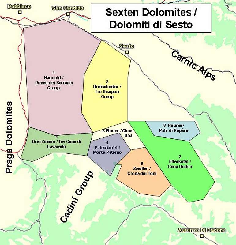
Overview map of the Sexten Dolomites. The eight subgroups are indicated in different colours.
Each of these groups will be described in a section below. Where a SP-page exists only the single summits are listed, elsewhere a short note on the characteristics will be given.
1 – The Haunold / Rocca dei Baranci Group

The Haunold Group is located in the northwest of the Sexten Dolomites. It is limited by Pustertal in the north, Höhlensteintal in the east, Rienztal in the south and Innerfeldtal / Val Campo di Dentro in the west. The Haunold Group is the largest subgroup of the Sexten Dolomites and is formed by three ridges (one a double ridge) which run (on the average) from NW to SE. It is a lonely group, only two hiking trails traverse it from west to east, obviously between the three ridges. The access distances are rather long so that the summits are rarely climbed. Nevertheless they offer quite a number of interesting routes.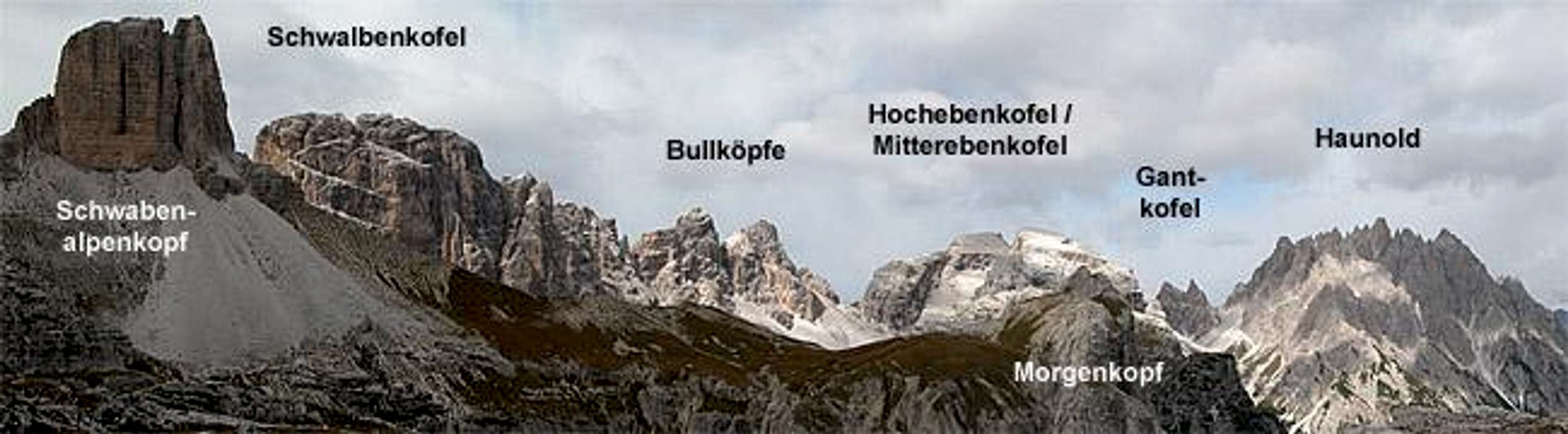
Northern Ridge
- Toblacher Neunerkofel / Cima Nove (2537m)
- Gantkofel / Cima Ganda
Three summits: SE summit(2697m), Central summit (2692m), NW summit (2614m) - Haunold / Rocca dei Baranci
Four summits: East summit (2907m), Main summit (2966m), West summit (2933m), South summit (2860m)
Lesser Central Ridge
- Kleiner Birkenkofel / Piccola Croda dei Baranci (2790m)
- Birkenschartlturm / Prima Torre dei Barranci (2653m)
- Birkenschartlkopf / Seconda Torre dei Barranci (2661m)
- Köhlerbrennturm / Torre del Carbone ( 2838m)
- Kohlalpelspitzen / Cime Pra Brusca ( five towers ~2800m)
- Bergmannturm / Torre Bergmann (2802m)
- Kohlalplkopf ( 2643m)
Major Central Ridge
- Birkenkofel / Croda dei Baranci (2922m)
![Sexten Dolomites photo_id=80559]()
- Hochebenkofel / Cima Piatta Alta (2905m)
![Sexten Dolomites photo_id=9177]()
![Sexten Dolomites photo_id=112718]()
- Mitterebenkofel / Cima Piatta di Mezzo (2870m)
- Unterebenkofel / Cima Piatta Bassa (2581m)
![Sexten Dolomites photo_id=112715]()


Southern Ridge
- Nasswand / Croda Bagnata (2254m)
- Ebenkofel / Dosso Piano (2463m)
- Nördlicher Bullkopf / Cima Bulla Nord (2817m)
- Südlicher Bullkopf / Cima Bulla Sud (2848m)
![Sexten Dolomites photo_id=112717]()
- Schwalbenkofel / Croda dei Rondoi (2873m)
- Rautkofel / Monte Rudo
Four summits: Teston di Rudo (2607m), Western summit (2737m), Central summit (2698m), Grosser Rautkofel / Monte Rudo Grande ( 2826m)
![Sexten Dolomites photo_id=86985]()


2 – Dreischuster / Tre Scaperi Group
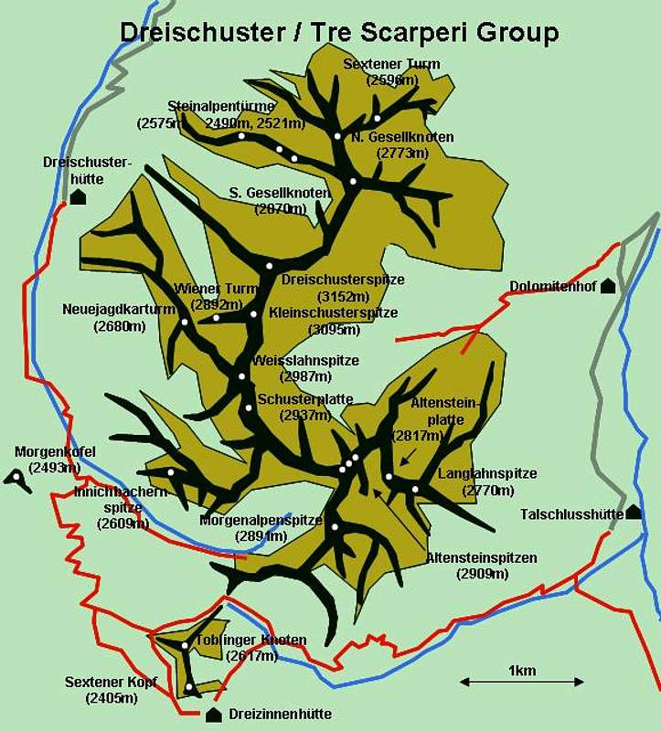
The highest group of the Sexten Dolomites is located centrally. It forms a long s-shaped ridgeline with multiple side ridges. Only at the south the ridge divides into two parts. Additionally three single standing summits are counted to this group, Toblinger Knoten / Torre di Toblin, Schwabenalpenkopf / Torre dei Scarperi and Morgenkopf / Monte Mattina. Geographically the subgroup is located between the lower Sexten Valley in the north, Innerfeldtal / Val Campo di Dentro in the west, Fiscleintal / Valle Fiscalina and Altensteinertal / Val del Sasso Vecchio in the west and the Drei Zinnen / Tre Cime Plateau in the south. Dreischusterspitze / Punta dei Tre Scarperi is the highest summit of the Sexten Dolomites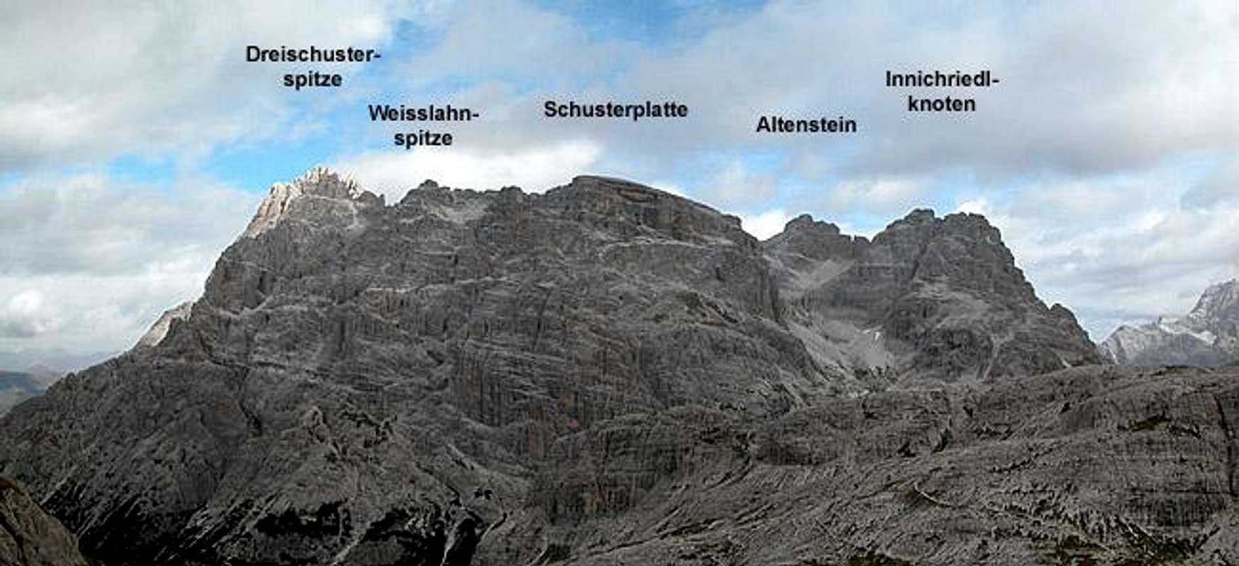
- Sextener Turm / Torre di Sesto (2596m)
- Nördlicher Gesellknoten / Cima di Sesto Nord (2773m)
- Südlicher Gesellknoten / Cima di Sesto Sud (2870m)
- Steinalpentürme / Campanili dei Sassi
Three Towers: Western (2575m), Central (2490m), Eastern (2521m) - Dreischusterspitze / Punta dei Tre Scarperi (3152m)
![Sexten Dolomites photo_id=86986]()
![Sexten Dolomites photo_id=120848]()
![Sexten Dolomites photo_id=120840]()
![Sexten Dolomites photo_id=120844]()
![Sexten Dolomites photo_id=120846]()
![Sexten Dolomites photo_id=120843]()
- Kleinschusterspitze / Punta Piccola Scarperi (3095m)
- Wiener Turm / Torre dei Viennesi (2892m)
- Neuejagdkarturm / Torre della Caccia (2680m)
- Weisslahnspitze / Punta Lavina Bianca ( 2926m)
- Innichbachernspitze / Torre Gioppi (2609m)
- Schusterplatte / Lastron die Scarperi (2937m)
See the Schusterplatte Page for more info.
![Sexten Dolomites photo_id=120764]()
![Sexten Dolomites photo_id=120778]()
![Sexten Dolomites photo_id=120833]()
![Sexten Dolomites photo_id=120834]()
- Altensteinspitzen / Punte Sassovecchio ( 2909m)
- Altensteinplatte / Lastron di Sassovecchio ( 2817m)
- Langlahnspitze / Punta Lavina Lunga (2770m)
- Morgenalpenspitze / Crodon San Candido (2891m)
- Toblinger Knoten / Torre di Toblin (2617m)
![Sexten Dolomites photo_id=9174]()
![Sexten Dolomites photo_id=9325]()
![Sexten Dolomites photo_id=79202]()
![Sexten Dolomites photo_id=60087]()
- Schwabenalpenkof / Torre dei Scarperi (2687m)
![Sexten Dolomites photo_id=77998]()
![Sexten Dolomites photo_id=60993]()
![Sexten Dolomites photo_id=118788]()
![Sexten Dolomites photo_id=118789]()
![Sexten Dolomites photo_id=118787]()
- Morgenkofel / Monte Mattina (2493m)
![Sexten Dolomites photo_id=110710]()
![Sexten Dolomites photo_id=110709]()
![Sexten Dolomites photo_id=112716]()
- Morgenkofelturm / Torre Monte Mattina (2260m)


 |
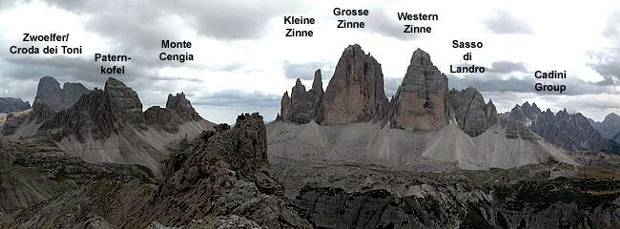
3 – Drei Zinnen / Tre Cime di Lavaredo
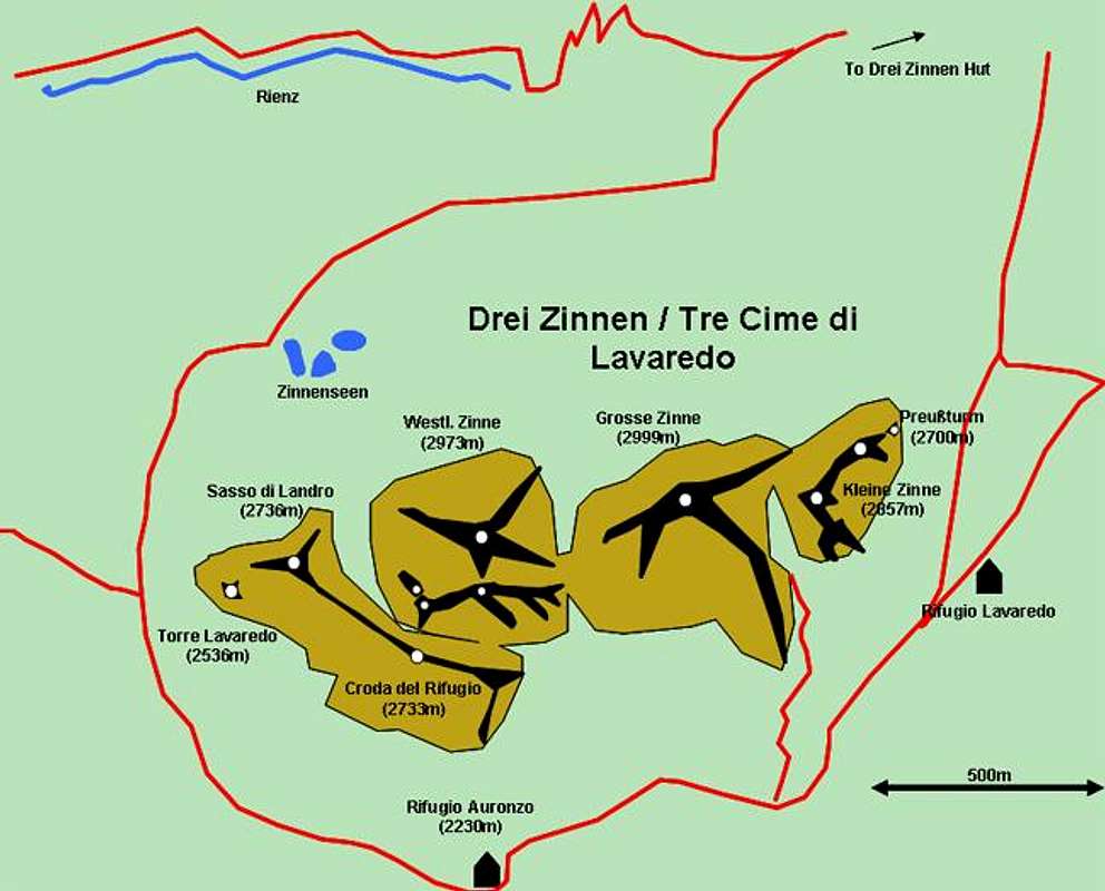
The Group has been described in detail on the respective Drei Zinnen page. Here only a listing of the respective summits is given. Additionally a couple of other summits which otherwise wouldn’t find a home in any subgroup are listed here.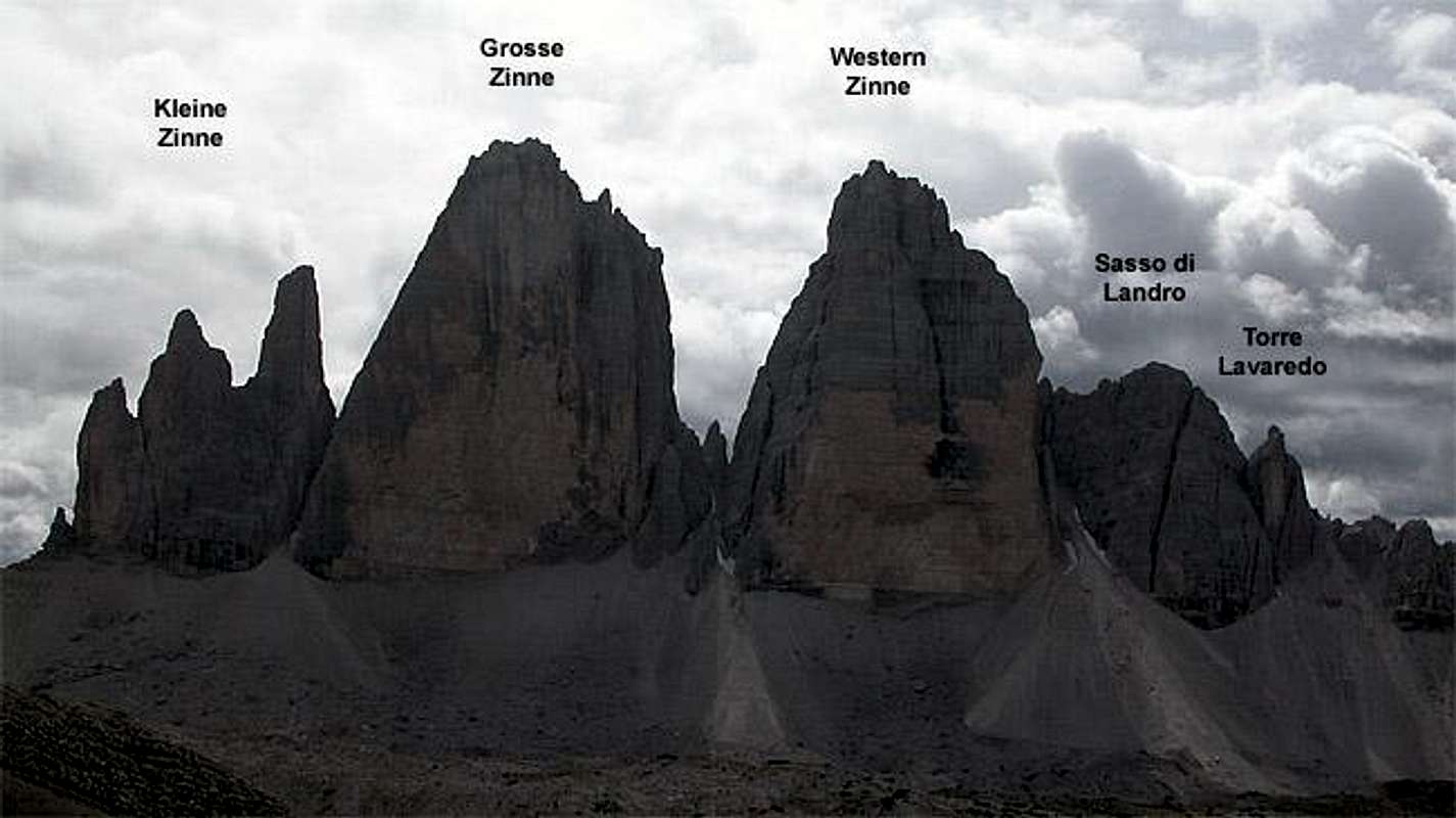
- Monte Piano (N, 2305m) – Monte Piana (S, 2325m)
Two summits which form a plateau along a long ridge. These summits have seen some of the worst fighting in WW I. The Austrians held Monte Piano, the Italians Monte Piana. The summit was strategically important as it looks over the narrow Höhlensteintal / Valle di Landro. Here more than a thousand soldiers lost their life fighting for some obscure hills. At Rifugio Bosi there is a Worlf War I museum. The old fortifications have partly been restored. - Rienzwand / Pianoro Col di Mezzo (2254m)
The Drei Zinnen Group
- Torre Lavaredo ( 2536m)
- Zinnenkopf / Sasso di Landro (2736m)
- Croda di Mezzo (2733m)
- Crode del Rifugio (2730m)
- Il Mulo (2800m)
- Croda degli Alpini (2865m)
- Westliche Zinne / Cima Ovest di Lavaredo (2973m)
![Sexten Dolomites photo_id=75521]()
- Grosse Zinne / Cima Grande di Lavaredo (2998m)
![Sexten Dolomites photo_id=75520]()
- Kleine Zinne / Cima Piccola di Lavaredo (2857m)
![Sexten Dolomites photo_id=75523]()
![Sexten Dolomites photo_id=75522]()
![Sexten Dolomites photo_id=38018]()
- Punta di Frida (2792m)
- Preußturm / Torre Preuß (also Kleinste Zinne / Cima Piccolissima, 2700m)


4 – Paternkofel / Monte Paterno
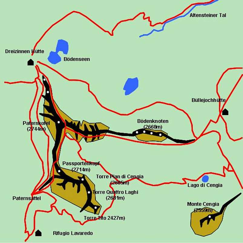
Also described elsewhere – for more information look at the Paternkofel / Monte Paterno Page. Summits from west to east.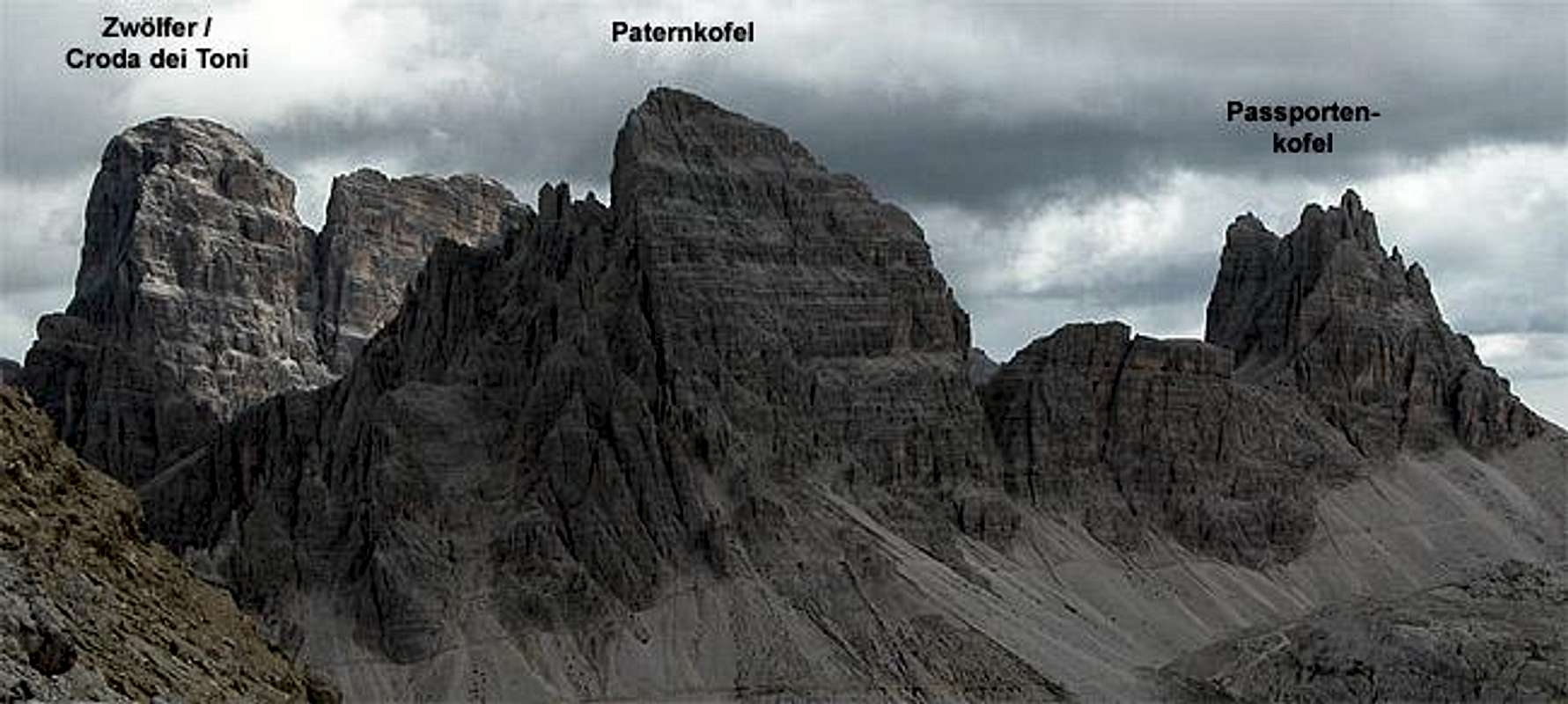
- Paternkofel / Monte Paterno (2744m)
![Sexten Dolomites photo_id=60817]()
![Sexten Dolomites photo_id=83797]()
![Sexten Dolomites photo_id=77783]()
![Sexten Dolomites photo_id=62514]()
- Passportenkopf / Croda Passaporto (2714m)
- Torre Pian di Cengla (2685m)
- Torre Quattro Laghi (2681m)
- Torre Tito (2427m)
- Gamsspitzen / Punte del Camoscetto
Four towers, all around 2700m - Monte Cengia (2599m)


5 – Einserkofel – Cima Una
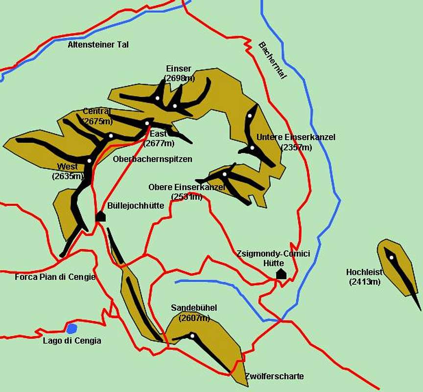
This subgroup in most publications either gets attatched to Paternkofel / Monte Paterno or Zwölfer / Croda dei Toni. It is, however separated from both by a kind of high plateau so that this subdivision seems quite arbitrary to me. Therefore I’ll put it up as a subgroup by itself. Einser – as well as the surrounding peaks – generally show steep (and high) north faces but mellow southern sides. Especially Oberbachernspitzen are quite popular among hikers since they don’t require much climbing knowledge and are easily accessible from two Rifugios: Büllelejochhütte / Rifugio Pian di Cengia and Rifugio Zsigismondy-Comici.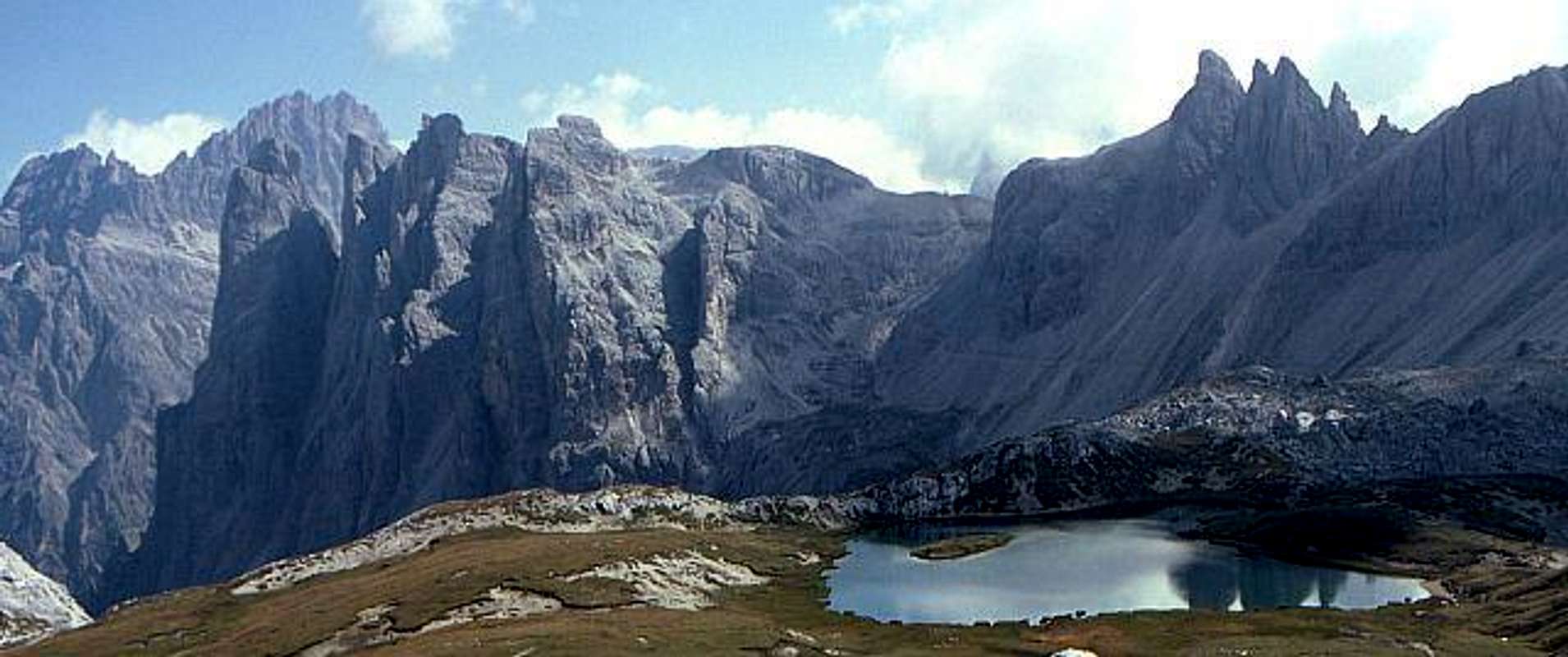
- Western Oberbachernspitze / Croda Fiscalina Ovest (2635m)
- Central Oberbachernspitze / Croda Fiscalina di Mezzo (2675m)
- Eastern Oberbachernspitze / Croda Fiscalina Est (2677m)
- Einserkofel / Cima Una (2698m)
- Obere Einserkanzel / Pulpito Alto (2531m)
- Untere Einserkanzel / Pulpito Basso (2357m)
- Sandebühel / Collrena (2607m)
- Hochleist / Lista (2413m)
6 – Zwölferkofel / Croda dei Toni

Also described elsewhere. Just look up the Croda dei Toni / Zwölferkofel Page. Lots of climbing routes here.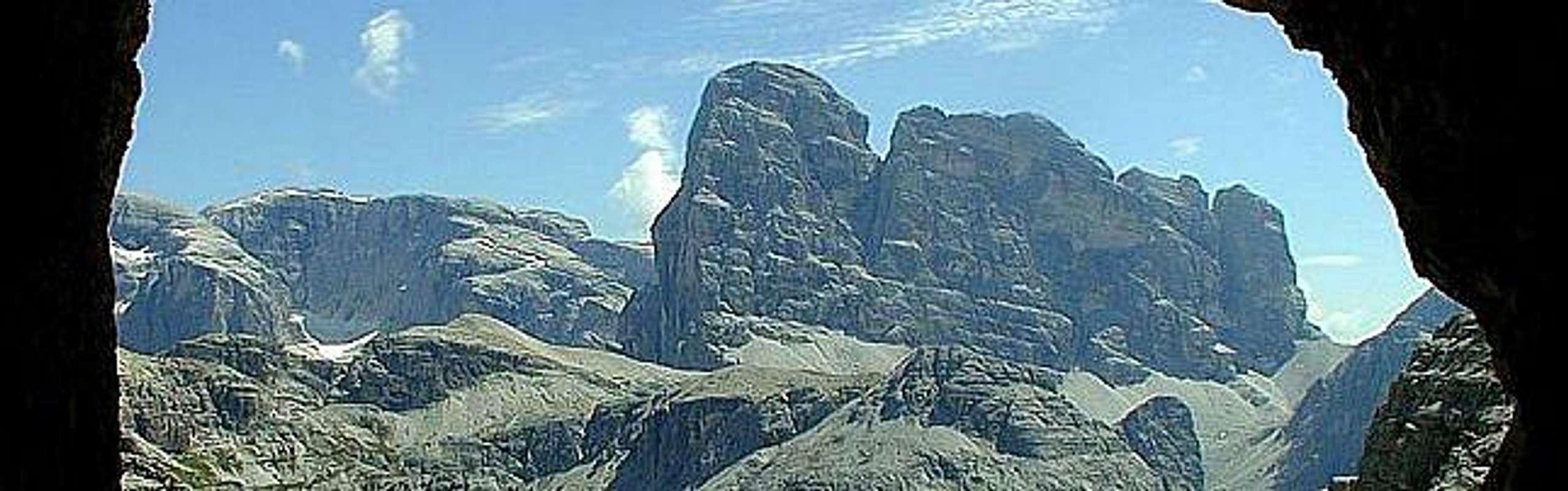
- Hoher Zwölfer / Croda dei Toni, Cima Dodici (3094m)
![Sexten Dolomites photo_id=80382]()
![Sexten Dolomites photo_id=82097]()
![Sexten Dolomites photo_id=80557]()
![Sexten Dolomites photo_id=80387]()
![Sexten Dolomites photo_id=80384]()
- Kleiner Zwölfer / Piccola Croda dei Toni (2917m)
- Zwölfertürme / Dame Vicentine
Three Spires around 2700m - Kleinster Zwölfer / Piccolissima Croda dei Toni (2728m)
![Sexten Dolomites photo_id=85693]()
- Innsbrucker Turm / Torre Sud (2800m)
- Mittlerer Zwölfer / Croda Antonio Berti ( 3029m and 3023m)
- Südlicher Zwölfer / Cima Sud Croda die Toni (2945m)
- Cima d’Auronzo (2914m)
- Torrione Carducci (2785m)
- Punta Maria di Val Giralba (2659m)
- Pala Val die Toni (2490m)
- Punta Grigia (2604m)
- Punta Vitalini (2540m)
- Prima Torre Piatta (2558m)
- Seconda Torre Piatta (2560m)
- Punta dell’Agnello (2736m)
- Campanile della Disgrazia (2511m)
- Torrione Graffer (2523m)
- Pala del Marden (2475m)
- Cime Pezzios (N: 2439m, S: 2445m)
- Croda Gravasecca (2326m)


7 – Elferkofel / Cima Undici - Hochbrunner Schneid / Monte Popèra
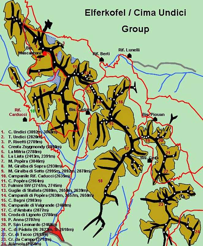
A long ridgeline (the longest in the group) which runs from Elferscharte / Forca Undici in the north to Zsygmondyscharte / Forca Zsygmondy in the south. It contains some of the wildest terrain of the whole Sexten Dolomite Group.Geographically it is wedged between Val Giralba and Bacherntal in the east and Val Comelico to the west. The summits are listed north to south.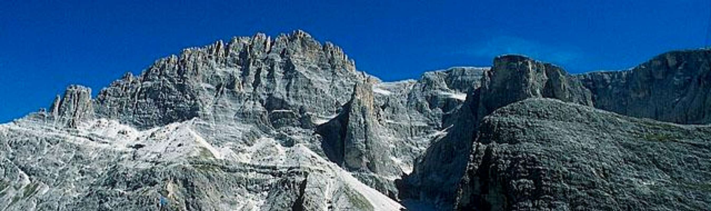
- Elferkofel / Cima Undici (S: 3092m, N: 3068m)
![Sexten Dolomites / Dolomiti di Sesto photo_id=87126]()
![Sexten Dolomites / Dolomiti di Sesto photo_id=86982]()
![Sexten Dolomites / Dolomiti di Sesto photo_id=86983]()
- Elferturm / Torre Undici (2820m)
- Elferkopf / Ounta Rivetti (2709m)
- Zsygmondykopf / Cresta Zsygmondy (2998m)
- Cima Madonna dei Caduti (2580m)
- Torrione Ribul (2740m)
- Torrione Mina (2560m)
- Hochbrunner Schneid / Monte Popèra (3046m)
- Monte Giralba di Sopra (2930m)
- Monte Giralba di Sotto (2995m, 2892m, 2878m)
- Campanile Rifugio Caducci (2635m)
- Pilastro d’Angelo (2620m)
- Cima Popèra (2964m)
- Fulmini SW (2747m)
- Fulmini NE (2745m)
- Guglie di Stallata (2680m, 2650m, 2639m)
- Campanili di Popèra (2630m, 2657m, 2650m)
- Cima Bagni (2983m)
- Campanile di Valgrande (2480m)
- Cima d’Ambata (2877m)
- Croda di Lignoto (2786m)
- Punta Anna (2707m)
- Punta San Leonardo (2468m)
- Cima di Pádola (N: 2623m, S: 2610m)
- Croda di Tacco (2612m)
- Croda da Campo (2712m)
- Torrione Canal (2490m)
- Aiárnola (2456m)


8 – Neuner / Pala di Popèra - Sextener Rotwand / Croda Rossa di Sesto
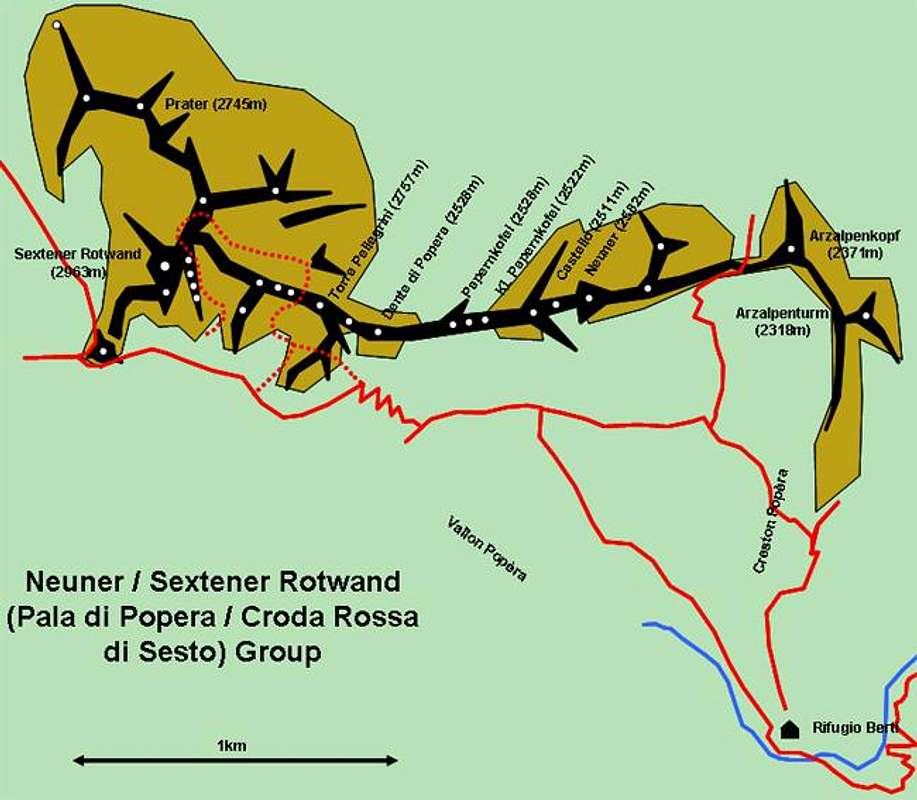
A small ridge on the northeastern side of the Sexten Dolomites just above Kreuzbergpass / Passo Montecroce Comelico. Known for the WW I trails that nowadays are used as ferrate. It is a quite popular destination for all kind of hikers and climbers due to the fact that the pass is so near and that a cableway can take you you up from Sexten to approximately 1900m. The ferrate are rather long though not too demanding so that they give you quite a nice closeup impression of these famous mountains. Nevertheless you’ll ask yourself why anybody had to fight a war in this altitude. The summits are listed southeast to northwest
- Arzalpenturm / Campanile Colesei (2318m)
- Arzalpenkopf / Croda sora i Colesei (2371m)
- Neuner / Pala di Popèra (2582m)
- Castello di Popèra (2511m)
- Kleiner Papernkofel / Gobba Piccola di Popèra (2528m)
- Papernkofel / Gobba Grande di Popèra (2522m)
- Dente di Popèra (2528m)
- Torre Pellegrini (2757m)
- Sasso Fuoco (2592m)
- Sextener Rotwand / Croda Rossa di Sesto (also Zehnerkofel / Cima Dieci, 2963m)
![Sexten Dolomites photo_id=95873]()
![Sexten Dolomites photo_id=97509]()
![Sexten Dolomites photo_id=98146]()
- Prater (2745m)


Getting There
From North
Take A22 Brenner Motorway to exit Brixen / Bressanone and turn off onto SS49 east. At Innichen / S. Candido turn south on SS52 towards Sexten.
From Austria
Take A12 Inntalautobahn to exit Kufstein. There turn onto 178, later 161 south in direction Kitzbühel. At Mittersill 161 turns into 108 which heads through Felbertauern Tunnel. Take 108 until Lienz were you turn right (west) onto E66. At Innichen / S. Candido turn south onto SS42 to Sexten.
From Udine
Take A23 north to exit Carnia. Turn off onto SS52 which leads through several detours to Sexten / Sesto.
From Venezia
Take motorway S27 north towards its end near Belluno. Turn onto SS51 towards Pieve di Cadore where you drive straight on on SS51a towards Auronzo di Cadore. Before you reach Auronzo at Santa Caterina take SP532 to Padola where you reach SS52 which you take in northwestern direction towards Sexten / Sesto.
Red Tape - The Natural Park Dolomiti di Sesto
In 1981 an area of 11650ha has been set aside for the natural Park Dolomiti di Sesto.
For more information you can look at
When to Climb
The best time - as usual within the Dolomites is June through September. October days can be picture perfect but the risk of snowfall is too high. Due to the rugged terrain and compared to the other Dolomite Groups there are only limited possibilities for ski tours.
Hotels and Appartments
For Hotels and appartments have a look at the websites of the towns and villages of the region:
Mountain Huts and Refuges
The following Mountain Huts, Refuges can be found in the Sexten Dolomites Group:
Rifugios:
| Rifugio / Hut | Height | Open | Tel. |
| Angelo Bosi | 2205m | June - Oct | +39 0436 39034 |
| Auronzo | 2330m | June - Oct | +39 0435 39002 |
| Berti / Al Popèra | 1950m | June - Sept | +39 0435 67155 |
| Büllelejochhütte / Pian di Cengia | 1950m | end June - mid Sept | +39 0337 451517 |
| Carducci | 2297m | July - Sept | +39 0435 400485 |
| Città di Carpi | 2110m | mid June - mid Sept / Dec - April | +39 0436 39139 |
| Col de Varda | 2115m | mid June - mid Sept / Dec - April | +39 0436 39041 |
| Dreischuster / Tre Scarperi | 1626m | summer only | +39 0474 966610 |
| Drei Zinnen / Tre Cime | 2405m | summer only | +39 0474 972002 |
| Fonda Savio | 2367m | mid June - mid Sept | +39 0436 39036 |
| Lavaredo | 2344m | June - Sept | +39 0436 39135 |
| Lunelli / Selvapiana | 1568m | June - Sept / Dec - March | +39 0435 67171 |
| Rotwandwiesen / Prati di Croda Rossa | 1924m | June - Oct / Dec - April | +39 0474 710102 |
| Talschlusshütte in Fischleintal / Fondo Valle | 1526m | June - Oct / Dec - April | +39 0474 710606 |
| Zsigmondy-Comici | 2224m | end June - end Sept | +39 0474 710358 |
Bivouacs:
| Bivouac | Height |
| Battaglione-Cadore | 2251m |
| Carlo Gera | 2240m |
| Dei Toni | 2578m |
| Mascabroni | 3092m |
Weather Conditions
For weather conditions look at
- www.meteoalpin.com. For the english text you have to scroll down the right frame.
- www.toblach.it
Webcams are available at:
Maps 'n' Books
Unfortunately I can only comment on the quality of books in German or English so that all of the books below are in these languages.Please feel free to post an addition to this section if you know worthwhile publications.
Books:
Climbing
Sextener Dolomiten extrem - Alpenvereinsführer
R. Goedeke
Rother Verlag
ISBN: 3 7633 1255 2
Classic Dolomite Climbs: 102 High Quality Rock-Climbs Between the Uiaa Grades III and VII (also available on CD)
Anette Kohler, Norbert Memmel
Mountaineers Books
ISBN: 0 8988 6693 6
Vie Ferrate
Klettersteige Dolomiten
H. Höfler, P. Werner
Rother Verlag
ISBN: 3 7633 3096 8
Hülslers Klettersteigführer
E.E.Hülsler
Bruckmann Verlag
ISBN: 3 7654 4161 9
Hiking and Trecking
Höhenwege in den Dolomiten
H. Dumler
Bruckmann Verlag
ISBN: 3 7654 3860 X
Dolomiten 5
F. Hauleitner
Rother Verlag
ISBN: 3 7633 4199 4
Dolomiten
P. Fleischmann
Kompass Verlag
ISBN: 3 8705 1409 4
Maps
I have been using the maps by Kompass Verlag. There are two which differ in scale:
Sextner Dolomiten / Dolomiti di Sesto
Kompass Map WK 625
ISBN: 3 8549 1749 X
Scale: 1:25000
Sextner Dolomiten / Dolomiti di Sesto
Kompass Map WK 58
ISBN: 3 8549 1065 7
Scale: 1:50000
 |
 |
 |
 |
 |
External Links
- Escursioni nelle Dolomiti di Sesto
this is one of the fine pages by Tiziano