
-
 27105 Hits
-
 87.31% Score
-
 24 Votes
|
|
Canyon |
|---|---|
|
|
40.18510°N / 9.49730°E |
|
|
Overview
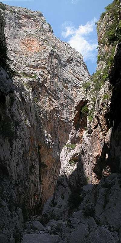 Gola su Gorrupu - never to see direct light Gola su Gorrupu - never to see direct light |
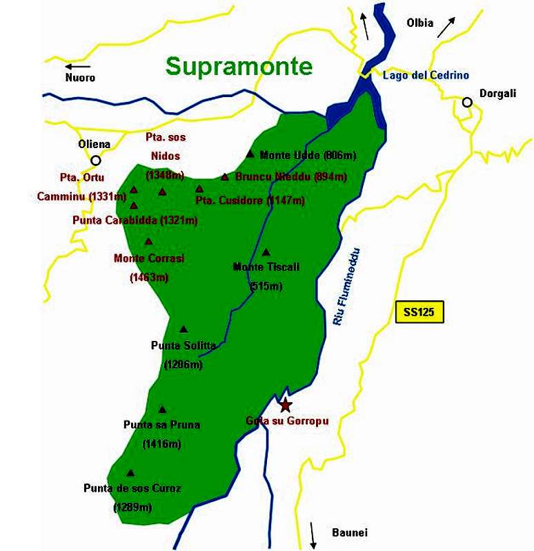
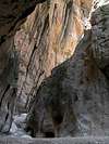
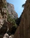
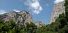
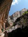
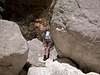
Gola su Gorropu is Europe's most profound gorge; it has been cut deep into the Supramonte karst plateau by Riu Flumineddu. The gorge itself is short, less than 5km long, and seen from above shaped like an inverted "S". It can be reached on foot or by mountain bike and if you have some money to spare you can hire a jeep Taxi to be carried to the entrance of the gorge. From there on it is bouldering over smoothly polished and slippery limestone rocks into a place that rarely sees the light of the sun.
In its narrowest places Gola su Gorropu is only some 5 to 10m wide with 300m high walls! Naturally there is climbing in the gorge - there are supposed to be 3 routes ranging from 6b+ to 8b in difficulty and reaching up to 400m in length. I have been too busy to find my way on the gorge floor to think of looking for bolts and other climbing signs.
The best time to explore the gorge is the early morning - from the trailhead you have to walk quite a way to get to the entrance and the Flumineddu Valley is open to the sun, making it a very hot place indeed. I have been there in late May and don't want to imagine what it might be like in summer.
Another reason for starting early is the popularity of the gorge. Though far away from anything the jeep taxis carry a lot of people to the entrance and the narrow walls throw back echoes all over the place. In some places you'll be able to hear what is whispered 200m away and you can imagine the noise level that an Italian travel group creates. Be fast and go far - the last caverns of the "inverted S" are reached only by real climbers.
As stated above the limestone rocks are very smooth and - when wet - very slippery. Therefore in each location where there is grade II or III bouldering to be done fixed ropes are provided (four places in all). The trail is not marked - and though you might think that it is difficult to lose your way in a narrow gorge - it might still be difficult to find. Take your time and rather turn back to try another approach than to go on.
Much info can be found at www.quarantesimo-parallelo.com, unfortunately in Italian (thanks to livioz for finding that link).
 |  |  |  |  |
Getting There
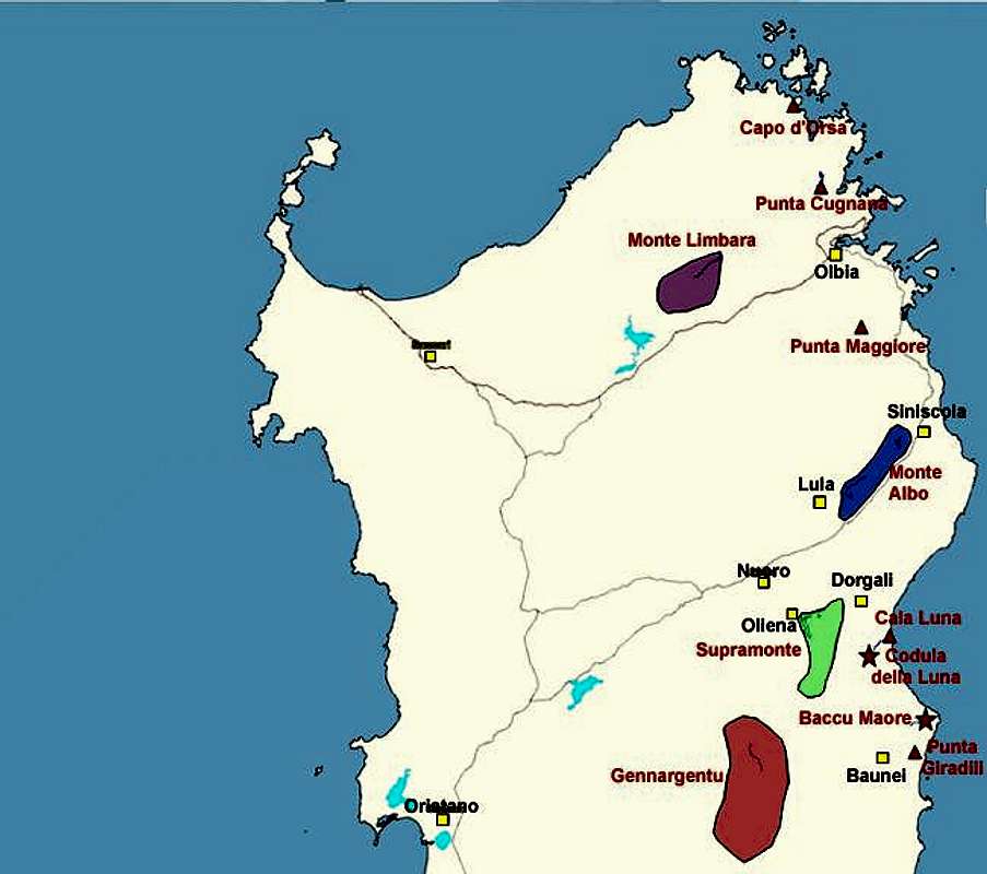
Sardinia can be reached either by plane or by ferry. The main ports are Porto Torres and Olbia in the north and Arbatax and Cagliari in the south. Airports are at Alghero and Olbia in the north as well as (again) Arbatax and Cagliari in the south. For exploring the northeastern part of the island where most of the mountains are the best entry point is Olbia, which is where most flights go anyway.Approaching the mountain from Olbia airport
Get on motorway SS 131 south in the direction of Siniscola / Nuoro. At the exit Lula / Dorgali get off and turn on SP38 south (again direction Dorgali). Shortly before you reach Dorgali, SP38 ends and you switch to SS125 direction Dorgali.
Get through the town (signs Cala Gonone, Baunei) and soon afterwards the road to Cala Gonone turns off through a tunnel to the left. Go straight on and 1km after the intersection take a narrow road to the right. This roads winds down into the Flumineddu Valley (always keep to the left (south)) and there takes you through vineyards and orchards. The asphalt ends after 8km. Go on for another 800m and you'll reach a parking lot near a picnic area on the shore of the river. From this parking lot you can either use a shuttle service or hike all the way to the mouth of the gorge. Hiking will take about 1h 15 min.
 |  |  |  |  |
Red Tape
Again, like in all Sardinia there are no limitations other than that you have to hike or bike the trail to the gorge entrance. The gorge itself belongs to "Parco Nazionale di Gennargentu, Golfo di Orosei", therefore the usual national park restrictions apply. Leave plants and animals in their natural surroundings and take your refuse back with you.The parking lot can be pretty crowded, many people park their cars, where the asphalt ends. Keep in mind that the Flumineddu Valley (not the gorge) is agriculturally used so park your cars in a way that the local farmers can still access their fields and vineyards.
 |  |  |  |
When To Climb
Gola su Gorropu can be climbed all year round. On wet days you might have to limit the exploration to the first couple of hundred meters. The rocks really are slippery. The best seasons should be late spring and summer, autumn already being to wet.Accommodation
Accomodation......is rather easy to find. Since all the interesting mountaineous regions are on the north and east coast - which is where the largest beaches are - you can book hotel rooms and appartments from any tourist office. The region around the town of Dorgali should be the best staying place since it is rather central to most of the interesting locations. Also Cala Golone is an interesting location. Still quite near to the gorge it also offers a variety of good and interesting climbs (chose among 150 different routes !!!! See www.sportextreme.com).
Camping...
... is also easy to find in the vicinity of the beaches. Look for locations, using www.sardegna.com.
Free camping is not allowed between the trailhead and the gorge but there is a "Rifugio Gorropu" in Flumineddu Valley which caters to climbers. They offer guided tours through the complete gorge, starting with the descent from high Supramonte.
Weather Conditions
Go for the following link, which is in Italian but with ALL the information you might want to have on weather on the island:www.sar.sardegna.it.
Head for the "meteo" button and then on the "Bollettino dettagliato" link in the left frame.
Maps 'n' Books
As for Maps I used only a road map scale 1:200000 since the guidebook I used has maps and is really quite good. Don't be fooled by the durations they state, you'll be much faster but the "getting there's" and "route description's" are very good.The book is:
Sardinia (Sardegna / Sardinien)
M. Omidvar
Rother Verlag
ISBN: 3-7633-4800-X (English)
ISBN: 3-7633-4143-9 (Italian)
ISBN: 3-7633-4023-8 (German)