
|
|
Mountain/Rock |
|---|---|
|
|
44.72580°N / 15.04000°E |
|
|
Hiking, Sport Climbing |
|
|
Spring, Summer, Fall, Winter |
|
|
5344 ft / 1629 m |
|
|
Google Earth
Since Google has blessed us with its magical Google Earth software you can visit any corner of the world from the chair parked in front of your computer. Thankfully Velebit is amazingly clear so you can discover its corners and see for yourself how it looks from the above and where are the places this page is dedicated to.Each geographical point of interest described on this page has coordinates on the top of its section. You can use these coordinates with Google Earth’s fly to search engine. Just copy the coordinates (like it is written, with coma) and paste them into fly to tab and press enter. And, of course, enjoy the flight!
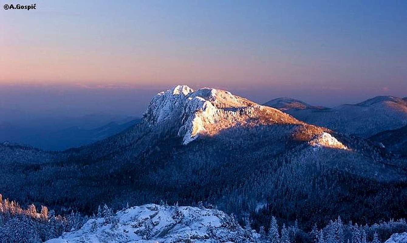
Veliki Kozjak (1629m)
44°43'55.32"N, 15° 2'3.66"EVeliki Kozjak (1629m) from the north, from the Kuk (1649m) in Hajducki Kukovi group
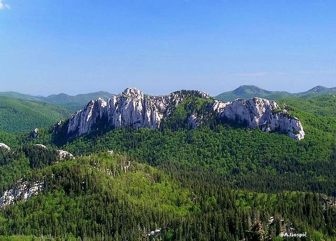 Fantastic harmony of smooth white limestone cliffs and deep beech and spruce forests, above which they rise, make Veliki Kozjak one of the most beautiful and recognizable peaks on entire Velebit. Also its position in one of the most beautiful, and easily accessible, corners of Velebit make Veliki Kozjak very desirable and popular peak. Fantastic harmony of smooth white limestone cliffs and deep beech and spruce forests, above which they rise, make Veliki Kozjak one of the most beautiful and recognizable peaks on entire Velebit. Also its position in one of the most beautiful, and easily accessible, corners of Velebit make Veliki Kozjak very desirable and popular peak.Position. Veliki Kozjak is placed in southern part of North Velebit, close to the border with Mid Velebit which runs in W-E direction. It is often said that it stands on the continental edge of North Velebit. In the other parts of Velebit that would be exact but North Velebit is widest part of Velebit and is very complex. There are many lower peaks and ridges east of Veliki Kozjak, before massif finally descends into the fields of Lika region, in this case Lipovo Polje field. Veliki Kozjak is placed in the heart of Velebit, when looking in W-E (width) direction, almost equally distant from the sea and Lika. Surroundings. Veliki Kozjak is surrounded by valleys from all sides and is stand alone peak. On the north is Kizjanska Draga valley which separates it from parallel but lower Mali Kozjak (1466m). Valley is under deep spruce and beech forests. Mali Kozjak stands between Veliki Kozjak and Hajducki Kukovi group. On the northwest, almost 400m lower, is famous Veliki Lubenovac field (1250-1315m). It is rounded grassy depression surrounded with spruce forests fantastic peaks (more in its own section). Behind Veliki Lubenovac Rozanski Kukovi rise. On the west Veliki Kozjak is separated from Alancic – Seravski Vrh – Golic group by forested pass. This pass is highest point of Vranjkova Draga valley which is south of Veliki Kozjak and separates it from Goljak (1605m) and its group. Valley is also under deep spruce and beech forests with one larger meadow, Vranjkovac. On the east Veliki Kozjak towers high above the end of 15km long Bakovac valley which cuts deep into the massif of Velebit from Kosinjsko Polje field in Lika. Its sides are forested and steep with some cliffs. On the gradually rising bottom there are large meadows and even larger fields, at the beginning. Peak. Veliki Kozjak has long, by beech forested crest above which groups of white fortresses rise. Yes, cliffs of Veliki Kozjak are smooth and high and look like impregnable fortresses. Well, for everyone except climbers who found numerous attractive and demanding routes in the their white limestone towers and faces. Crest of Veliki Kozjak stretches in NW-SE direction. It begins with Obli Kuk (1501m) (Rounded Cliff) on the NW end, right above Veliki Lubenovac. Obli Kuk isn’t really an imposing cliff but just a larger pile of rocks which rises above the forest, barely. Main part of Veliki Kozjak is placed almost kilometer SE of Obli Kuk. Between them is forested crest. Main part begins with western group of cliffs, whose north face is around 200m high. Then comes middle group which contains two similarly high peaks. The eastern one is highest. Between them is deep funnel shaped depression/hole. Highest peak has 80m high western face above the hole. North face of middle group is biggest on Veliki Kozjak and is also 200m high. Just east of main summit is eastern group whose northern cliffs are also up to 200m high. The crest of Veliki Kozjak ends here and east side steeply falls into deep Bakovac valley. Access. Thanks to the greed of forests service which opened macadam forest roads all around, Veliki Kozjak it is superbly accessible peak. In fact it is too easy. From the road in Vranjkova Draga valley it takes only 1.15h to the summit. There is also a path which leads over Obli Kuk and is bit longer. Spot where path to Veliki Kozjak branches from Vranjkova Draga road is accessible from 3 directions. On the north is nearby Veliki Lubenovac hut/refuge, from the west path approaches from Veliki Alan pass and from east path leads through Vranjkova Draga valley on its way from Stirovaca valley. How to get there is described in routes section. Although Cliffs of Veliki Kozjak make it look like fortress main summit has one weak point which was used by marked path so generally climb is easy. Today Veliki Kozjak is very popular and frequently visited, especially in summer. On disposal to hikers are two huts. Veliki Lubenovac hut (1315m) is at the foot, some 1.30-1.45h from the summit. Bit further is Alan hut (1340m), some 2.30h from the summit. If there weren’t roads which access both huts and encircle Veliki Kozjak it would be difficult peak to visit. From the coast it takes over 6h to reach it while from Lika it would be even more on foot. In autumn there is less people, out of weekends generally nobody. When snow covers Velebit roads Veliki Kozjak becomes lonely peak, rarely visited by tour skiers and mountaineers from Alan pass. When will snow disappear from the roads varies from year to year but generally it happens during last part of May. In some years roads in high areas of Velebit, to which Veliki Kozjak and its roads belong, are not passable even in the first third of June. Protection. In 1999 North Velebit National Park was established but although Veliki Kozjak is one of most beautiful peaks of North Velebit and Velebit in general it hasn’t been included in the park. This was quite a shock for all Velebit lovers. At first it was thought it is compromise with Forest Service because they lost Stirovaca valley but it turned out that they had nothing to do with it and couldn’t dictate the borders but those that did didn’t have a clue about Velebit and value of Veliki Kozjak. Hopefully this terrible mistake will be straightened in first revision of the park. In the mean time forest service can cut the trees around Veliki Kozjak. |
Veliki Kozjak (1629m) from the west, from Rozanski Kukovi
-----------------------------------------------------------------------------------------------------------------
 |  |  |  |  |
Climbing on Veliki Kozjak
In mid 90’s of past century beautiful white limestone cliffs of Veliki Kozjak attracted climbers. It is quite strange why it took them so long to discover what was offered on a plate all the time. Although Veliki Kozjak is quite high and remote peak on Velebit it is superbly accessible to climbers because it is completely encircled by macadam forests and one doesn’t have to bother with long approach.There are 3 groups of cliffs which are lined along the long crest which stretches in NW-SE direction: western, middle and eastern. Height of the cliffs varies. Main characteristic of western group are smooth north walls while middle and eastern groups consist of many smooth towers. Cliffs of all groups reach 200m height. So far over 30 routes have been climbed in the cliffs of Veliki Kozjak. Some are quite demanding as they reach grade VII. Below are most important routes with height and difficulty.
-----------------------------------------------------------------------------------------
WESTERN GROUP
NE face of WESTERN group
Skriveni Kamini (Hidden Couloirs): 90m, I-V
Generacijski Sklad (Generational Harmony): 100m, I-V
S face of WESTERN group
Obadov Let (Gad-fly’s Flight): 90m height, I-IV+


-----------------------------------------------------------------------------------------
MAIN GROUP
NE face of MIDDLE group
Karijes (Caries): 200m, II-VI
Caminito Mallorquin: 200m, II-VI
Allegro, Ma Non Troppo (Briskly, But Not too Much): 160m, VII
Allegro Cantabile (Briskly as a Song): 70m, III
Plomba (Tooth Filling): 200m, II-VI
SW face of MAIN SUMMIT
Najvisi Kamin (Highest Couloir): 80m, I-IV
Vilenjakov Greben (Elf’s Crest): 80m, I-III


-----------------------------------------------------------------------------------------
EASTERN GROUP
NE face of EASTERN group
Imbljuni: 200m, II-VI+
Strigin Smjer: 150m, I-VI
Strigica: 120m, I-V+
Kroz Dvoranu Gorskog Kralja (Through the Hall of the Mountain King): 180m, II-VI


Summit View
View from the summit of Veliki Kozjak is wide and very beautiful but it is orientated on inner Velebit and its continental side and further spreads towards Lika region. This means sea is not visible but almost whole of Velebit is, from Zavizan on North Velebit to Crnopac on SE Velebit. Most dominant feature in the view are forests of this part of Velebit, which are on your palm and spread as far as eye can see. Many peaks rise above them. Most beautiful are white cliffs of Rozanski Kukovi and nearby peaks and cliffs of Hajducki Kukovi. On the other side numerous grassy domes stick on Mid Velebit. Of those Satorina is most eminent.N: right below disappearing northern cliffs are forests in Kizjanska Draga valley. Behind it is Mali Kozjak (1466m) with Begovaca valley further behind it. Behind Begovaca is large area of dark undulating peaks of Hajducki Kukovi. Out of forests many white cliffs peak. Unmistakable are Jurekovacki Kuk (1525m) and Begovacki Kuk (1404m) peaks with quite big south faces. Behind Jurekovacki Kuk are two highest peaks of Hajducki Kukovi: Golubic (1650m) and Kuk (1649m). Just right of them, over not visible Lomska Duliba valley, Mali Rajinac (1699m) and Veliki Rajinac (1667m) stick.
E: in this direction there are many parallel ridges, mostly forested, before Lika region. Most important feature of close surroundings is 15km long Bakovac valley which begins below Veliki Kozjak and stretches in ESE direction between lowering forested sides till they melt into Kosinj field. Among the forested fore hills of Velebit, right of Kosinj field, one can notice small part of blue Kruscicko Jezero accumulation lake on Lika river. Further behind is Lika region which is closed by long ridge of Licka Pljesivica mountain, some 65km away.
S: beginning of Bakovac valley is from S closed by large and rounded forested group of Veliki Golic (1550m). Large rounded forested peak on the left side of the group is Veliki Obljak (1501m). Behind the group is large Licko Polje field in Lika and long crest of South Velebit. Further behind Lika, in SE direction, some Bosnian mountains are visible, like Osjecenica (1798m) and Klekovaca (1961m). Right of the Veliki Golic group and behind nearby white fortress of eastern groups of cliffs is huge basin of Stirovaca valley. In the southern direction two eminent peaks stand. Left if forested Laktin Vrh (1504m) while right is huge topless pyramid of Satorina (1624m), highest peak of Mid Velebit. Between these two peaks are white cliffs of Bacic Kuk (1304) and small pyramid of Prikinuto Brdo (1264m), just right of it. Right of Satorina, in SW direction, some of the highest Mid Velebit peaks are lined up: Matijevic Brijeg (1611m), Malovan (1610m) and Ogradjenik (1604m). Streak ends with Zecjak (1622m) and its several smaller heads, on the WSW.
W: in the WSW direction, over Vranjkova Draga valley, stands beautiful grassy cone of Goljak (1605m). In the W direction below the main summit is deep funnel shaped hole and second highest peak of Veliki Kozjak behind it. Further back is grassy Alancic (1611m) and towards right grassy Seravski Vrh (1661m), which sticks behind left side of bulky and forested Goli Vrh (1669m). Right of it is forested pass which separates it from Rozanski Kukovi group, which occupies NW part of panorama. They begin with Krajacev Kuk (1659m), on the left end, and end with Vratarski Kuk (1767m), on the right, at least from this perspective. Right below Vratarski Kuk is Lubenovacka Vrata pass (1474m) that separates Rozanski Kukovi from Hajducki Kukovi.
 |  |  |
Goljak (1605m)
44°43'23.82"N, 15° 0'43.68"EGoljak (1605m) from the Rozano high plateau
 Goljak (1605m) is beautiful and very symmetrical grassy cone placed SW of Veliki Kozjak (1629m). It is highest peak of its own group which is surrounded by valleys and encircled by forest roads. The group itself has many nice grassy domes which rise above nice beech forests that are decorated with scattered spruces. The group stretches from NW to SE and is parallel with nearby Veliki Kozjak but much wider. Vranjkova Draga valley separates Goljak group from Veliki Kozjak on NE (Vranjkova Draga road runs through the valley). On the SE is Mrkviste pass (1276m) that separates the group from Veliki Golic (1550m) group on Mid Velebit (part of Krasno – Stirovaca asphalted road makes border). SW border of Goljak group is also part of the border between North and Mid Velebit. It is quite deep valley which has fantastic series of huge meadows at the bottom: Bilenski, Segotski and Dundovic Padez (Alan pass road runs along the valley). On the NW is valley which separates Goljak from Alancic (1611m) – Seravski Vrh (1661m) group. Half of the valley is forested by beech and spruce while SW half contains huge grassy Tudorevo which is similar to series of Padez meadows (Alan pass – Veliki Lubenovac road runs along the valley). Goljak (1605m) is beautiful and very symmetrical grassy cone placed SW of Veliki Kozjak (1629m). It is highest peak of its own group which is surrounded by valleys and encircled by forest roads. The group itself has many nice grassy domes which rise above nice beech forests that are decorated with scattered spruces. The group stretches from NW to SE and is parallel with nearby Veliki Kozjak but much wider. Vranjkova Draga valley separates Goljak group from Veliki Kozjak on NE (Vranjkova Draga road runs through the valley). On the SE is Mrkviste pass (1276m) that separates the group from Veliki Golic (1550m) group on Mid Velebit (part of Krasno – Stirovaca asphalted road makes border). SW border of Goljak group is also part of the border between North and Mid Velebit. It is quite deep valley which has fantastic series of huge meadows at the bottom: Bilenski, Segotski and Dundovic Padez (Alan pass road runs along the valley). On the NW is valley which separates Goljak from Alancic (1611m) – Seravski Vrh (1661m) group. Half of the valley is forested by beech and spruce while SW half contains huge grassy Tudorevo which is similar to series of Padez meadows (Alan pass – Veliki Lubenovac road runs along the valley).Main characteristic of the group are soft and nice grassy domes. On the NW of the group is large grassy peak Veliki Golic (1570m). Its SE neighbor is Goljak (1605m) while bit farther towards SE if whole group of small grassy domes Mali Golic (1577m). Between the peaks there is lot of funnel shaped holes with rocky or grassy bottoms. View from the summit of Goljak is wide and very beautiful, especially towards Rozanski & Hajducki Kukovi groups and Veliki Kozjak, Bakovac valley and Bilenski Padez. Behind Bilenski Padez are numerous grassy domes and peaks of Mid Velebit. Over the Alan pass even some sea is visible with high Losinj island. Marks reached summit of Goljak from two directions. Southern approach leads from Alan road and Kosica pass (1414m), which is highest point of Alan road. Marks lead over the Goljak’s neighbor Veliki Golic (1570m). This beautiful approach is combination of tame beech forests and open grassy slopes. From the road it takes around an hour to the summit. Northern approach leads from the valley between Goljak group and Alancic / Rozanski Vrh / Seravski Vrh group. Trailhead is on the road which runs through the valley and connects Alan Pass road with Veliki Lubenovac. It takes around an hour to the trailhead both from Alan and Lubenovac huts. Path mostly goes through the forest except the grassy summit slopes. It takes some 40mins to the summit from the road. |
 |  |  |  |  |
Veliki Lubenovac (1265-1315m)
Refuge (burned down, to be rebuild): 44°44'24.59"N, 15° 0'56.09"EBottom: 44°44'43.75"N, 15° 0'49.95"E
Veliki Lubenovac is one of the most beautiful and romantic spots on entire Velebit. It is large, round grassy field or basin, which has diameter of around 1km. It is surrounded by fantastic spruce forests. Lowest point of Veliki Lubenovac is at 1265m while forest edge is at 1315m. Veliki Lubenovac is surrounded by three fantastic groups of peaks and white cliffs, which rise above dark spruce forest. On the NW is Rozanski Kukovi group, on the N Hajducki Kukovi and Veliki Kozjak, on the SE.
On the southern end of the field, at the edge of the forest, Veliki Lubenovac (1315m) hut is placed. Hut is great base for longer stay and daily trips in the closer and farther surroundings.
 |  |  |
Tudorevo (1290-1370m)
44°43'30.82"N, 14°59'13.16"ETudorevo is beautiful grassy, oval shaped, depression in the SW part of the valley which separates Goljak (1605m) and its group from Alancic (1611m) – Seravski Vrh (1661m) group. From all but SW side where Tudorevo touches, over grassy ridge, nearby Mirevo grassy valley, it is surrounded by beech forests, with some spruce. Edge of the forests ends in horizontal line which follows the contour of 1360m. Towards NE and Veliki Lubenovac other forested half of the valley stretches. Peaks well over 1500m rise NW and SE of Tudorevo, in both groups.
As other nearby grassy valleys: Mirevo, 3 Padez’s and Veliki Lubenovac, Tudorevo is very beautiful, idyllic and relaxing place. By its SW edge, where it touches Mirevo, Alan road passes, on the way from Alan to Stirovaca. Also on that spot road branches towards Veliki Kozjak and Veliki Lubenovac. At first it goes over the meadows but most part along Tudorevo road leads through forest, just above the valley. Marks from Alan towards V.Kozjak and V.Lubenovac follow the road.
 |
Hike Advices
Daily trip from coast to Veliki Kozjak and back is only option for strongest hikers. It is best to position yourself for few days on Veliki Lubenovac and do daily trips from the hut. You can get there either on foot from the coast or by car from various directions. From there Veliki Kozjak is 3-4h trip, both ways. If you have only two days at disposal sleep over at the hut and return to coast tomorrow. But once here it would be shame not to visit Rozanski and Hajducki Kukovi groups also. The last one is a half day trip from V.Lubenovac so you can include Hajducki Kukovi and Veliki Kozjak in same day. Rozanski Kukovi can be combined with Zavizan as a daily trip.Here is one beautiful daily combination from V.Lubenovac. From the hut head to Mali Rajinac (1699m), highest peak of North velebit, via Lubenovacka Vrata pass and Lomska Duliba valley. From the summit continue via Jezera, high grassy plateau, to Zavizan hut. From the hut head to Rozanski Kukovi via famous Premuziceva Staza. Once at Rossijevo Skloniste refuge, in the heart of Rozanski Kukovi, you have 3 options to return to V.Lubenovac: via Skrbina Draga, via Vratarski Kuk or via Premuziceva Staza and under Krajacev Kuk. Most beautiful but most demanding is via Vratarski Kuk but after such day there is hardly time left for such undertaking. If you want to climb Vratarski Kuk sleep over in Rossijevo Skloniste and do it tomorrow or return in the same day under Krajacev Kuk because that way you get to see the part of Premuziceva Staza through southern part of Rozanski Kukovi.
Getting There
Wider center of the region is Senj town on Velebit coast. Local centers are Krasno village on North Velebit and Jablanac on the coast below Alan pass. Heart of the area and trailhead to visit Veliki Kozjak is Veliki Lubenovac field. It can be accessed on foot from Jablanac or by car from various directions, including Jablanac and Krasno. Public transportation can be used to access both places while towns and villages in Lika region are too far from this part of Velebit to be accessed on foot.by Plane
Zagreb international airport is air gateway to Croatia. More info about flights find on official site of Croatia Airlines. From Zagreb you have to take a bus towards Senj.
by Bus
There are several bus lines from Zagreb to Senj each day. Also there are lines towards Rab and Pag islands that after Senj continue along the Velebit coast till Jablanac (ferry to Rab) or Prizna (ferry to Pag is after Jablanac so also suitable). Detailed bus timetables from Zagreb find on Zagreb bus station site. Also in Senj you can wait the buses from Rijeka which head towards south.
by Car
This is always best possible option which gives you freedom to do and go wherever you want. There are three main directions to come to this area, from Rijeka, Zagreb or Zadar.
GENERAL ACCESS:
From Rijeka, along the coast
This route is suitable if you are coming from western Europe, via Trieste (Italy).
Trieste – Rijeka: 70km
Rijeka – Senj: 63km
Senj – Jablanac: 38km
From Zagreb
This road is suitable if you are coming from eastern or central Europe via Ljubljana (Slovenia), Maribor (Slovenia) or Budapest (Hungary).
Ljubljana – Zagreb: 138km, Maribor – Zagreb: 113km, Budapest – Zagreb: 347 km
Zagreb – Senj: 156km
Senj – Jablanac: 38km
Zadar – Starigrad Paklenica – Jablanac: 120km
LOCAL ACCESS:
Jablanac – Alan pass – Veliki Lubenovac: 28km
Senj – Sveti Juraj – Krasno – Begovaca – Veliki Lubenovac: 56km
Otocac – Krasno – Begovaca – Veliki Lubenovac: 50km
Look for current road conditions in Croatia on the page of Croatian Automobile Club (HAK)
 |
When To Climb
Learn more about Velebit climate on Velebit mountain main page.Winter: on Veliki Kozjak lasts from mid November till May. In this period Velebit is under deep snow which reaches its peak in February or in March. This changes from year to year. To ascent Veliki Kozjak crampons are necessary because on exposed places snow is usually transformed into white concrete by Bura wind. On the other hand in deep forests around Veliki Kozjak it will usually be soft. Most dangerous factor is Bura wind which often reaches hurricane force. It brings terrible wind chill. Because of snow remains on some years roads around Velki Kozjak are not usable even in first third of June. In mid winter upper part of Alan road is under snow or huge drifts built by Bura wind. This makes Veliki Kozjak tough bite in winter as one has to climb from the coast or somewhere up the road, till the point it is passable. It is best to approach with tour skies.
Spring: snow begins to melt faster as April progresses but still falls frequently. Real spring begins in last third of May when trees turn green. Depending from year to year this can also be delayed till beginning of June. That is fantastic time to visit because forest is fluorescent green. Flowers reach their peak during second half of June.
Summer: lasts between end of June till end of August. July and August are real hell months on the coast with daily temperatures regularly around 35°C. Avoid day time ascent from the coast then because sun kills. On high elevations there is plenty of shade in the forests. Temperatures rarely reach 25°C on Veliki Kozjak. They usually range between 15-21°C. First snow falls many times at the end of August but it doesn’t last long then. But even in summer some warm clothes like jacket and one long sleeve shirt are necessary. After cold front temps can drop to 5°C or lower even in summer. Also if you are spending nights on Veliki Lubenovac temps there drop considerably during the night.
Autumn: in highest area begins in last third of September. On Veliki Kozjak colors are at peak between September 25th and October 5th. This is fantastic period to visit. By the coast colors peak only at the end of October. In the second half of October snow is regular thing so have warm clothes with you.
 |  |
Mountain Conditions
Conditions on Velebit are very well known thanks to Zavizan meteo station, which is observing weather since 1953. On WeatherOnline & DHMZ (Croatian Meteorological and Hydrological Association) sites you can find current data for Zavizan and even forecast for Zavizan on WeatherOnline.Here are the links where you can find out about the current weather on Velebit (Zavizan) and forecast for Croatia:
WeatherOnline:
WeatherOnline home page
Croatia at WeatherOnline,
Zavizan at WeatherOnline
Croatian Meteorological and Hydrological Association (DHMZ):
DHMZ home page
DHMZ Forecast page
DHMZ 7 Day Forecast for Croatian cities and places World wide, including Zadar and Gospic
Current Weather Conditions in Croatia including Zavizan, Gospic and Zadar (from 5-15h and 19-21h, during summer +1hour)
Snow Depth's in Croatia
Objects
Planinarska Kuca Veliki Lubenovac (1315m) hut stands on the southern edge of Veliki Lubenovac field, surrounded by Rozanski Kukovi, Hajducki Kukovi and Veliki Kozjak. This is one of most beautiful corners of Velebit. Hut was build originally as foresters house and in 1994 handed over to mountaineers (Stanko Kempny mountaineering club from Zagreb). It was completely renovated in June of 2003 and 2004. It has 2 rooms and kitchen with 30 sleeping places. By the hut is water cistern. One room is open whole year as refuge while hut is open in summer season (June – October). It is accessible by car.Note: Unfortunately one of the most beautiful objects on Velebit, regarding interior and location, has been set on fire on November 12th 2004 after a fight between members of the mountaineering club who maintained the hut. Nothing but chimneys remained!
Kuca na Alanu (1340m) (Alan hut) stands by the Alan road, 500m from Veliki Alan (1375m) pass, on the seaboard side. Hut is at the edge of the forest below Alancic (1611m) peak and meadows around pass. It was build in 1960 as foresters house. Forestry service gave 2 rooms to mountaineers to be used as refuge. In 1990’s it was completely handed over to mountaineers. It is open all year and managed in summer season when is partially supplied with drinks. You can prepare your own food in kitchen. It has 45 sleeping places in 4 rooms and water cistern.
Visit Alan hut on the web.
Camping & Accommodation
Camping is forbidden on Velebit except on authorized places like camps but none is in the vicinity of this area. To stay on the mountain use huts and refuges. But by the Lubenovac hut there is camping place for several tents. Here are few links to help you find accommodation on the coast and around Velebit.Adriatica.net, accommodation on Croatian coast
Senj town page
Karlobag place accommodation
Hotel Ablana, Jablanac
Marijana apartments, Stinica
Otocac town in Lika region (behind Velebit), accommodation list
Lika-Senj county, various info about nature, places, accommodations…
Red Tape
As I mentioned in Veliki Kozjak/protection section on top of page Veliki Kozjak wasn’t included in newly founded North Velebit NP, which is terrible mistake. If you are going elsewhere on North Velebit you are required to buy a ticket in Veliki Lubenovac or Alan huts. Ticket is 30 kuna or 4 euros.Other Velebit pages on SummitPost
~ Velebit mountain, main page~ Zavizan area, North Velebit (Mali Rajinac (1699m) highest peak on the page)
~ Rozanski Kukovi group, North Velebit (Gromovaca (1676m) & Vratarski Kuk (1676m) highest peaks on the page)
~ Alancic / Rozanski Vrh / Seravski Vrh, North Velebit (Goli Vrh (1670m) highest peak on the page)
~ Satorina (1624m), Mid Velebit (including whole area between it and Alan pass)
~ Stap area, South Velebit, (Debeli Kuk (1269m) highest peak on the page)
~ Visocica (1619m), South Velebit
~ Bojin Kuk (1110m), South Velebit
~ Viserujna (1632m) & Rujno, South Velebit
~ Paklenica area, South Velebit
~ Vaganski vrh (1757m), South Velebit (highest peak of Velebit)
~ Liburnija (1710m), South Velebit
~ Sveto Brdo (1751m), South Velebit
~ Tulove Grede (1120m), SE Velebit
~ Crnopac (1404m), SE Velebit
Note: Text on this and pages above is copyrighted and cannot be used in any kind of publications.