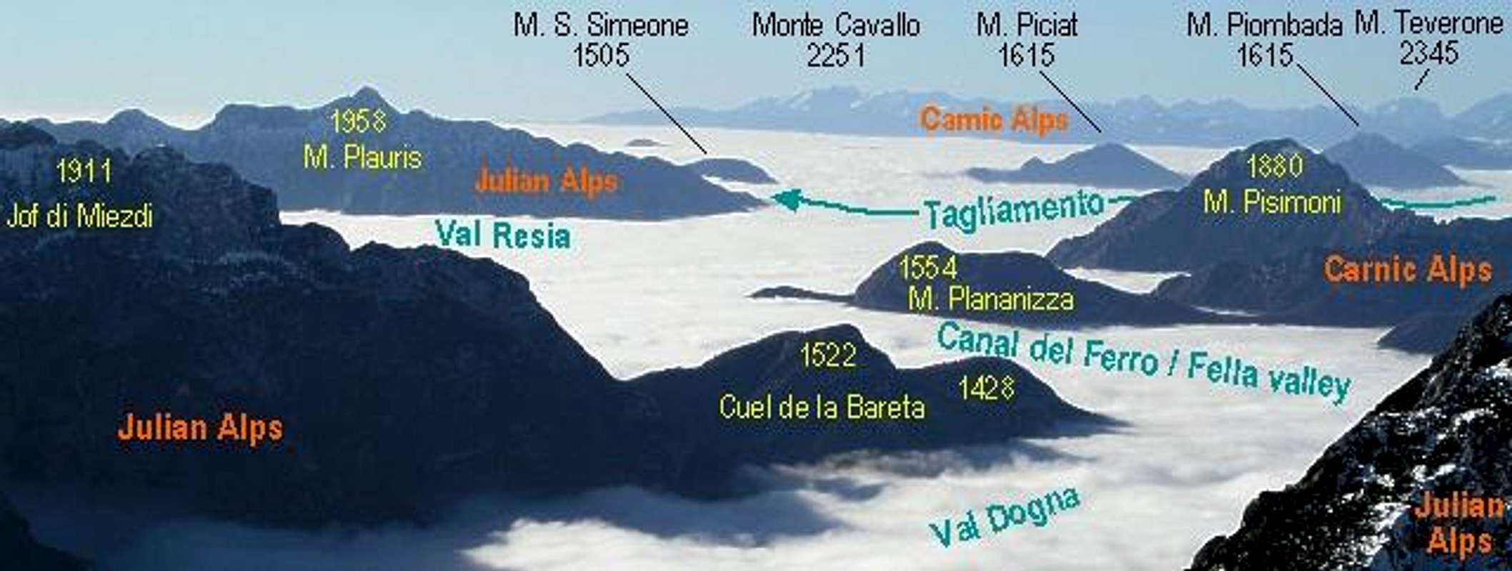
Prealpi Carniche (South)

Prealpi Carniche (South)

Page Type Page Type: Area/Range
Location Lat/Lon: 46.13000°N / 12.47000°E
Additional Information Elevation: 8106 ft / 2471 m
Sign the Climber's Log

Overview

Prealpi Carniche (South) photo_id=118795
View from the western Julian Alps towards the southwest. Monte Cavallo in the southern Prealpi Carniche can be seen in the background. Photo by Vid Pogachnik
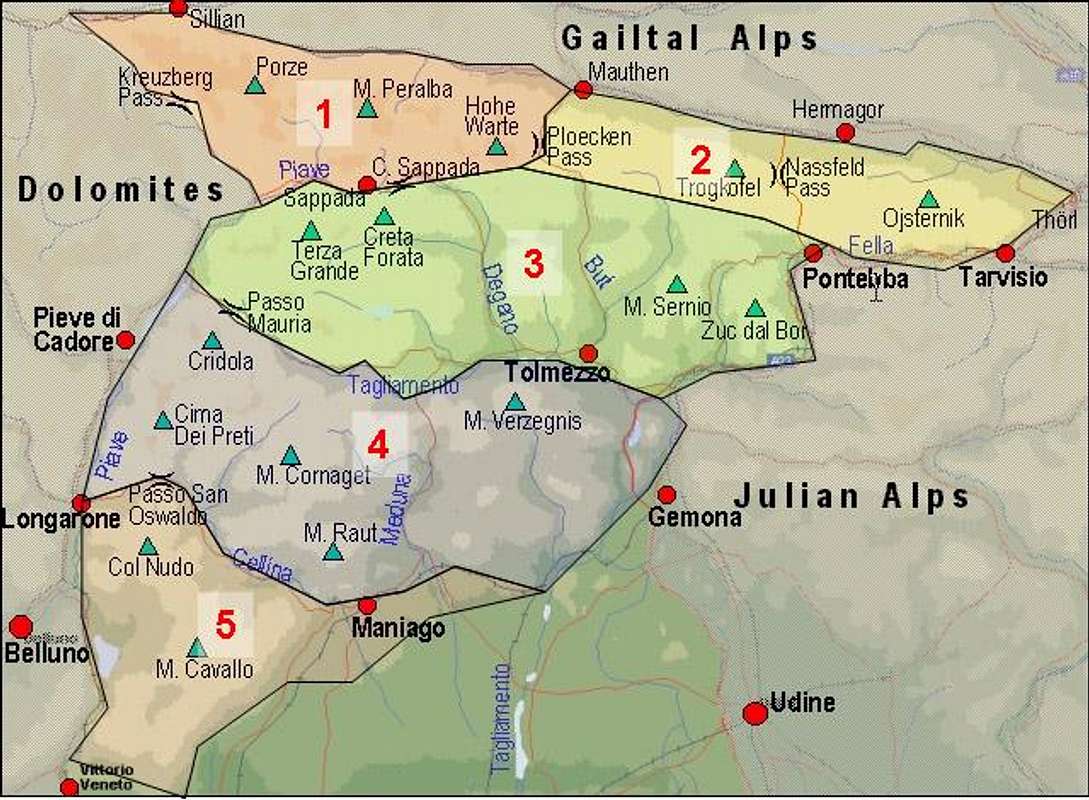
As discussed in a thread in the Europe Forum we divided the Carnic Alps Mountain Range into five subgroups. The Prealpi Carniche (South) is the third group to be posted to SP and is the southernmost subgroup of the whole range.

Carnic Alps Main Ridge (West)Carnic Alps Main Ridge (East)Southern Carnic AlpsPrealpi Carniche (North)Prealpi Carniche (South)
Interactive overview map of the Carnic Alps. The southern part of the Prealpi Carniche can be found to the south in subgroup 5. Subgroups, which have already been posted can be reached by clicking the numbers

The southern part of the Prealpi Carniche is wedged into a triangle between the Piave (W) and Cellina (N, E) Rivers with the southern Julian Alps to the east and the Dolomiti Bellunese to the west. It is located in the regions of Veneto and Friuli Venezia Giulia in nearly equal parts. There are three large lakes in the range, Lago di Santa Croce to the West, Lago del Vaiont to the northwest and Lago di Barcis to the northeast.

The group consists of three distinctive parts
  • A large ridge in its center running north to south but doing an s-shaped bend. Here you find the most important mountains Col Nudo, Monte Messer and Monte Cavallo. For the sake of organisation this ridge has been divided into three subgroups on this page, one for each of the principal summits.
  • A lesser (and lower) ridge to the east with Monte Ciastelat as its most important summit.
  • An assortment of three small but separate grouplets to the north of the range with Monte di Toc, Monte Certen and Monte Frugna as their principal summits.

Prealpi Carniche (South) photo_id=122723

Akira2008 notified me of the Vajont Dam disaster, which in 1963 took the lives of 2000 people. The dam and according reservoir were filled though it was known that Mount Toc had become instable by the intrusion of water. In 1960 a first landslide had occurred but nevertheless the water level in the reservoir was increased. On Oct 6th 1963 268 million cubic meters of materiall slid off Mount Toc, creating a huge, mushroom like tsunami of 50 million cubic metres of water. The tsunami rushed down the Piave valley, incredibly leaving the dam itself unharmed. To read more, see here.

1 - Northern Subgroups

Prealpi Carniche (South) photo_id=122724

In the north of Col Nudo there are three small subgroups which are divided by relative large plains. The mountains themselves don’t reach 2000m but form great ridges just like the rest of the Prealpi Carniche.

Monte di Toc Group (listed west to east)
  • Monte Ranz (1213m)
  • Cresta Vasei (1560m)
  • Col di Gai (1684m)
  • Monte Toc (1921m)
  • Cima Mora (1938m)
  • Becco di Toc (1860)
  • Croda Bianca (1764m)

Monte Certen Group (listed west to east)
  • Monte Certen (1883m)
  • Cima dell’Ardoto (1841m)
  • Monte Cornetto (1792m)
  • Cima di Tola (1752m)
  • Cima il Galinut (1755m)
  • Cima Pozzi (1345m)

Monte Frugna Group (listed west to east)
  • Zucculat (1630m)
  • Monte Frugna (1839m)
  • Pala Giuliana (1385m)
  • La Spia (1349m)
  • Croda Pineta (1202m)

2 - Col Nudo Group

Prealpi Carniche (South) photo_id=122725

Col Nudo is the highest summit among the Prealpi Carniche Sud mountains. It is a massive block composed of four ridges which run to its top. While the two northen ridges are very short and steep, the south-western ridge runs along for approximately 6km and starts at the village of Soccher. The southern Ridge has a bend to the east at Monte Teverone from where it runs into the direction of Crep Nudo. Here the Monte Messer Ridge starts to the south.

Col Nudo Northern Ridge (listed north to south)
  • I Teraz (1501m)
  • Croda de Magor (2128m)
  • Pala dei Ampès (2277m)
  • Anticima Nord (2460m)
  • Col Nudo (2471m)

Col Nudo North-Western Ridge (listed north to south)
  • Cima di Camp (1557m)
  • Cima di Pino Nord (1856m)
  • Cima di Pino Sud (2057m)
  • Cima del Colatoio (2157m)

Col Nudo South-Western Ridge (listed south-west to north-east)
  • Cresta di Campigol (1593m)
  • Cresta di Soccher (1506m)
  • Monte Dolada (1938m)
  • Col Dolomieu (1801m)
  • Col Mat (1981m)
  • Cima della Meda o Ciot (1587m)
  • Cimon delle Basiliche o Cima Degnona (2208m)
  • Cima Sora il Ciot (2318m)
  • Cima Secca (2350m)

Col Nudo Southern Ridge (listed north to south)
  • Cima Lastei (2439m)
  • Cima della Pala di Castello (2195m)
  • Cima Valar (2302m)
  • Monte Teverone (2345m)
  • Cimon del Teveron (2328m)
  • Monte Fagoreit (2094m)
  • Monte Crepon (2107m)

3 - Monte Messer Ridge

Prealpi Carniche (South) photo_id=122726

The central section of the southern Prealpi Carniche is the long Ridge around Monte Messer. It starts in the north at Col Martin and ends at Monte Sestier in the southm where it meets the Monte Cavallo Main Ridge. There is a trekking trail, Alta Via Monti dell’Alpago, which follows the whole ridge. There are no side ridges in this part.

Monte Messer Ridge (listed north to south)
  • Col Martin (968m)
  • Monte Provagna (1696m)
  • Monte Castello (1714m)
  • Palon (1647m)
  • Crep Nudo (2207m)
  • Capel Piccolo (1890m)
  • Capel Grande (2071m)
  • Dente di Venal (1982m)
  • Monte Venal (2212m)
  • Monte Antander (2184m)
  • Monte Messer (2230m)
  • Monte Paster (2067m)
  • Monte i Muri (2049m)
  • Monte Sestier (2084m)

4 - Monte Cavallo Group

Prealpi Carniche (South) photo_id=122727

The Monte Cavallo Group is the southernmost subgroup of the whole Carnic Alps. It is located between the villages of Piancavallo in the east and Tambre in the west. Alta Via Monti dell’Alpago also runs a long part of its main ridge but leves to the west at Cimon di Palantina.

Main Ridge (listed north to south)
  • Zuchel delle Mughele (1254m)
  • Monte Il Piz (1755m)
  • Monte Caulana (2068m)
    Prealpi Carniche South photo_id=122772

  • Cima Val Grande (2007m)
    Prealpi Carniche South photo_id=122797

  • Cima Val Piccola (2133m)
  • Monte Laste (2247m)
  • Cimon del Cavallo (also Cima Manera, 2251m)
    Prealpi Carniche South photo_id=122795Prealpi Carniche South photo_id=122794

  • Cimon di Palantina (2055m)
  • Monte Colombera (2066m)
  • Monte Forcella (1902m)
  • Monte Tremol (2007m)
  • Zuc Torondo (1838m)
  • Col Corner (1767m)
  • Zuc di Valliselle (1632m)
  • Monte Candole (1681m)

Western Side Ridge (turning off at Monte Laste)
  • Monte Cornor (2170m)
  • Monte Castelat (2208m)
    Prealpi Carniche South photo_id=122796

  • Monte Guslon (2195m)
  • Cima delle Vacche (2058m, 2063m)

Eastern Side Ride (turning off at Cimon del Cavallo)
  • Cimon dei Furlani (2183m)

5 - Monte Ciastelat Ridge

Prealpi Carniche (South) photo_id=122729

To the east of Monte Cavallo you find a long but low ridge which stretches from Lago di Bàrcis towards Piancavallo.

Monte Ciastelat Ridge (listed north to south)
  • Croda del Pic (1295m)
  • Monte I Cameroni (1470m)
  • Pala d’Altei (1528m)
  • Monte di Mezzo (1425m)
  • Monte Ciastelat (1641m)
  • Pala Fontana (1637m)
  • Col Spizzat (1472m)
  • Col Ceschet (1394m)
  • Colle delle Lastre (1408m)
  • Monte Caseratte (1264m)

Getting There

The principal towns in the area are Vittorio Veneto in the south, Longarone in the north-west and Maniago in the north-east, all three located at the tips of the "triangle", which the southern Prealpi Carniche form. They can be reached best from the western side of the group so that both the northern as well as the southern itinerary follow the valley of the Piave river. The City of Belluno is located to the west of the group and can also be easily reached.

From the South (Venezia)
From Venezia take motorway A27 direction Belluno. If you want to go to the eastern side of the group turn off at either San Vendemiano or Vittorio Veneto in direction Sacile, where you take SS 422 to Maniago. To get to Longarone in the north-west just follow the motorway to its end and follow SS51 to the town.

From the North (Brenner/Brennero)
Take the Brenner Motorway A22 to Brixen/ Bressanone where you turn east ont SS49 through Pustertal / Val Pusteria. Shortly before you reach the Austrian - Italian Border turn onto SS51 south at Innichen / San Candido. You'll reach Longarone and Vittorio Veneto directly by this road. To reach Maniago in the east turn east onto SS251 at Longarone.

Red Tape

There is a Parco Naturale delle Dolomiti Friulane which includes the northern part of the Prealpi. In the southern region there is a natural reserve controlled by the park called "Riserva naturale della forra del Cellina" which preserves the canyon of the Cellina river, one of the most suggestive italian canyons.

When To Climb

As usual with most of the mountains of the region the climbing and hiking season is June through September. You can be lucky before and after that but this depends on the overall weather. Except for the long main ridge all mountains make for good ski tour destinations.

Accommodation

Look at the following sites for accommodation (hotels and appartments). I'm sure there must be more but so far I haven't been able to find it.


As for mountain huts and refuges, please see the corresponding section on the Carnic Alps Main Page.

Weather Conditions

For up to date weather information follow one the links below.

Maps 'n' Books

Maps
Alpago, Cansiglio, Piancavallo, Valcelina
Tabacco Map 012
1:25000
Editione Tabacco
As for books please look at the corresponding section of the Carnic Alps page (only Italian).

Additions and CorrectionsPost an Addition or Correction

Viewing: 1-2 of 2
Gangolf Haub

Gangolf Haub - Jun 6, 2009 4:35 am - Hasn't voted

Re: Not only in Veneto

Thanks - I added your information and placed a link to a website about the Vajont Dam disaster.

Gangolf Haub

Gangolf Haub - Jun 7, 2009 1:42 am - Hasn't voted

Re: Not only in Veneto

Whatever you want ;-)

Viewing: 1-2 of 2


Children

Children

Children refers to the set of objects that logically fall under a given object. For example, the Aconcagua mountain page is a child of the 'Aconcagua Group' and the 'Seven Summits.' The Aconcagua mountain itself has many routes, photos, and trip reports as children.

Parents 

Parents

Parents refers to a larger category under which an object falls. For example, theAconcagua mountain page has the 'Aconcagua Group' and the 'Seven Summits' asparents and is a parent itself to many routes, photos, and Trip Reports.

Carnic AlpsAreas & Ranges