
-
 10393 Hits
-
 87.31% Score
-
 24 Votes
|
|
Mountain/Rock |
|---|---|
|
|
46.61960°N / 12.88350°E |
|
|
8070 ft / 2460 m |
|
|
Overview
Geographical Classification : Eastern Alps > Carnic Alps > Carnic Alps Main Ridge (West) > Rauchkofel

"It is not always the highest mountain which is the best lookout point."
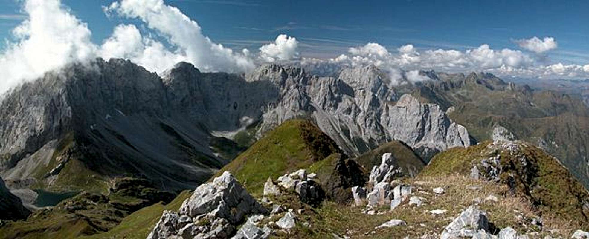
To prove this remark, which must have been posted on SP a hundred times, you just have to consider the mountain you are just about to read the overview section of. Rauchkofel is a relatively minor summit located to the north of the Carnic Alps Main Ridge. From the south it is invisible because it hides behind the giant walls of Hohe Warte / Coglians and Kellerwand (the highest mountains of the Carnic Alps), from the north it can be barely distinguished as a structure in front of these walls. You need to step to the side - like shown on the picture above (taken from Peralba to the west) - to actually see the mountain between its larger neighbours.
Rauchkofel actually is so close to Hohe Warte that only its summit peeps out of the shadow of its southern neighbour. Much of the ascent route(s) - especially the eastern one from Valentin Alm - go through perpetual shadow. This is why you can find the lowest glacier of the whole Alps, Eiskar at 2269m, in the north face of Kellerwand. The proximity also makes Rauchkofel the perfect place to observe the climbers who venture on "Koban-Prunner Weg", the sparsely secured ferrata through the north-face of Hohe Warte. Though in general rated UIAA I (II in a few short sections) the ferrata is very exposed and has but few fixed ropes and cables.
The top of Rauchkofel is split into two summits, the western one at 2436m, the eastern one at 2460m. Both are separated by a small saddle (2400m) located close to the western summit. Both are very small in size (summit area) and given the popularity of Rauchkofel it might be a good idea to head for the lower western summit to enjoy some solitude. All in all, the mountain can be easily climbed. There is a short UIAA I section if you take the route from Valentin Törl Pass and the final scramble from the saddle to either of the summits is exposed. Still most of the ascent routes run along grassy slopes and don't pose any problems.
As said above Rauchkofel is pretty popular among the hikers in the area. The main reason is that at Wolayer See, at the south-western base of the mountain you can find two refuges. One, Wolayer See Hütte, is located on Austrian territory directly beside the lake, while the other, Rifugio Lambertenghi-Romanin can be found across the border on the southern side of the shallow Wolayer Pass. Both refuges and the pass are separated by only 10m of altitude.

The main reason for the popularity, however, is the perfect location of this lookout mountain. While Hohe Warte and Kellerwand can almost be touched the best views are along both sides of the Carnic Alps Main Ridge. You have the bend of Biegengebirge on the western side above and behind which tower the likes of Peralba and Zwölferspitz. To the east you have a close-up on the Mooskofel Group with the beautiful bulk of Gamskofel up front and deep views towards the Gailtal and Carnic Alps behind. To the north you can see the long chain of the Lienz Dolomites with the major glaciated mountains of Hohe Tauern right behind.
Part of the ascent trails run along a so called "Geo-Trail" - you will find explanations about the geology of the area on signs distributed beside the paths. The whole area, but mainly the Rauchkofel - Gamskofel - Mooskofel Group is well known for its geologic complexity. During the build-up of the Alps this region was obviously hit hardest - looking at the rock layers you find in the area you cannot help but being confused. Geologists now believe that the build-up occurred in some sort of tidal waves which swept the region and broke across the Peradriatic Fault, which runs through the Lesachtal and Gailtal Valleys to the north. Thus the whole layering has been "shaken not stirred" with old layers to be found above newer ones.
As a side note - the Peradriatic Fault separates the North-African and European tectonic plates. This makes the inhabitants of Mauthen, the southern part of Kötschach-Mauthen, Africans, while the Kötschach people to the north of the Gail River can be considered Europeans :-)
Last - but not least: Vid found out, that Rauchkofel is rated as one of the finest ski tours in the Carnic Alps. As reference the German book by Manfred Korbaj: "Kaerntner Schitourenfuehrer". You can find its data here.
 |  |  |  |  |
Summit Views
I'm afraid there will be two summit view sections - so many pictures have already been posted to other pages...
 |  |  |  |  |
Getting There
There are two starting points for the ascent of Rauchkofel: Nostra located in the south of Lesachtal Valley and Untere Valentin Alm near the Plöckenpass Road. You can reach them as follows:
From the West (Brenner Motorway A22)
Leave the Brenner Motorway near Brixen / Bressanone and follow SS49 to the east through Pustertal / Val Pusteria. To the east of Innichen / San Candido you cross the Austrian-Italian border and follow the road (now B100) to Tassenbach. Turn right (south-east) here onto B111, which you follow in direction Mötschach-Mauthen. Between Mattling and Birnbaum the road to Nostra turns off right. For the eastern trailhead at Untere Valentin Alm you need to go on to Kötschach Mauthen were you turn south on B110 direction Plöckenpass / Italy. Close to a large bend in the road the side road to Untere Valentin Alm turns off (signs).
From the North
There are two possible roads:
- From Kitzbühel over B108 through the Felbertauern Tunnel to Lienz, then southeast to Oberdrauburg and Kötschach-Mauthen (B110), where you turn on to B111 west into Lesachtal for the Nostra trailhead or go on in direction Plöckenpass / Italy.
- From Salzburg along motorway A10 to Spittal. Turn west on B100 to Oberdrauburg, there south to Kötschach-Mauthen were you turn east on B111 for Nostra or stay on B110 for Untere Valentin Alm.
From the South (Udine)
Take Motorway A23 to the exit Camia Tolmezzo. Follow SS52 north to Tolmezzo where you turn onto SS52 bis. This leads to Plöckenpass, where it crosses the Austrian-Italian border. In Austria the road turns into B110 and shortly after the Pass you'll reach a long bend in the road where the side road to Untere Valentin Alm turns off (signs). For the Nostra trailhead you have to turn east on B111 into Lesachtal Valley at Kötschach-Mauthen.
 |  |  |  |  |
Red Tape
The only place, where I have become aware of red tape in the Carnic Alps is here in the region around Wolayer See (Hohe Warte Group and Biegengebirge). This area is a natural preserve. On the other hand you have to keep in mind that you are on the border between Austria and Italy. Though borders have less and less meaning in Europe today, an ID-card should be in your backpack.
 |  |  |  |  |
When To Climb
The climbing season is May through September. As stated in the overview section the ski tour ascent of Rauchkofel is considered one of the finest tors of the Carnic Alps, though difficult. It runs through the climbing section near Valentin Törl Pass but I suppose that with enough snow cover this section won't be too serious.
 |  |  |
Accommodation
There is no need to camp out near the mountain since there are two refuges in the vicinity, Wolayer See Hütte and Rifugio Lambertenghi e Romanin. Please refer to the relevant section on the Carnic Alps page for more information (opening times, phone numbers).
There are small campgrounds in Lesachtal Valley mostly associated with an inn or hotel. A large campground can be found at Kötschach Mauthen. If you are looking for hotel rooms or apartments follow one of the links below
- Lesachtal official site
- Kötschach/Mauthen official site
- Lesachtal lodging (tiscover.at)
- Hochpustertal lodging (tiscover.at)
Weather Conditions
The Carnic Alps Main ridge is a weather divide in northern or southern wind conditions so it pays to keep informed. Look at one of the links below :
Related Pictures posted to other SP Pages
 |  |  |  |  |
 |  |  |  |  |
 |  |  |  |  |
 |  |  |  |  |
Maps 'n' Books
Maps
I have been using maps by Kompass Verlag, which are very good for the hiking trails though they don't show ALL the relevant summits of the area.
- Lienzer Dolomiten / Lesachtal
1:50000
Kompass Map WK47
Kompass Verlag
ISBN: 3-85491-053-3
As for books please look at the appropriate section of the Carnic Alps page.