
-
 15071 Hits
-
 79.78% Score
-
 11 Votes
|
|
Mountain/Rock |
|---|---|
|
|
46.55700°N / 13.44500°E |
|
|
Hiking, Skiing |
|
|
Spring, Summer, Fall, Winter |
|
|
6269 ft / 1911 m |
|
|
Overview
Summits, described here
On this page you will find some information about the following summits:
> Monte Cocco / Kok, 1941 m,
> Cima Bella / Schoenwipfel / Lepi vršič, 1911 m,
> Monte Sagran / Sagranberg / Konjščica, 1922 m,
> Starhand, 1968 m,
> Monte Stabet, 1630 m.
General
Normally these summits would not get their own pages. They are too humble and exceed only a little the main ridge of Carnic Alps. But they are so nice and popular (especially Cima Bella / Schoenwipfel / Lepi vršič) for tour skiing! In a high winter, when there's a lot of fresh snow and higher mountains are dangerous for ski tours, summits like these gain importance. On January 1st, 2005, for example, we came late, started to ascend around 11 am, but two hours later on the summit of Cima Bella / Schoenwipfel / Lepi vršič we still met some 15 skiers, enjoying warm sun and broad panorama.
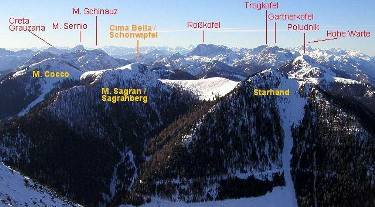
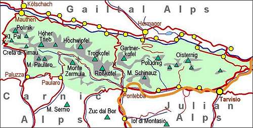
On the map below, you can see that the main crest of Carnic Alps goes over Cima Bella / Schoenwipfel / Lepi vršič and Monte Sagran / Sagranberg / Konjščica, while Starhand stands north of it, and Monte Cocco / Kok to the south.
As said, these mountains are highly valued as ski goals and in summer of course also as hiking destinations. Because of many forest roads also mountain biking should be great. Panoramas from their summits are very fine.
All four summits are easily accessible. High on these mountains forest roads and cart-roads reach, too many to describe them all. See more information under Routes Overview chapter and on the interactive map!
And there's the fifth mountain, worth of mentioning. On the very south of this group, above Val Kanale, Monte Stabet, 1630 m is rising. We ascended it one winter day, but were surprised with no view around. Unfortunately, we haven't visited Mezesnik alpine meadow, east of the summit, which must have some view around.
Abandoned Mines
On the eastern slopes of Monte Cocco / Kok, till mid 20th century a mine of iron, nickel and manganese was operating. In the village up to 200 people wele living. Today the whole infrastructure is closed, but the site is touristically arranged as one of the most interesting geo-sites of Northern Italy In the neighbourhood also some very old rocks can be seen. See the map below how to get there!
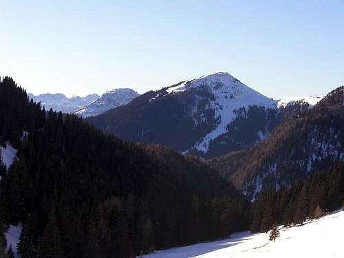
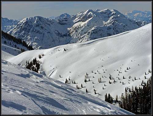
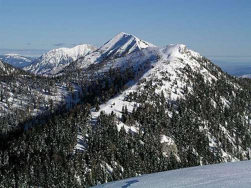
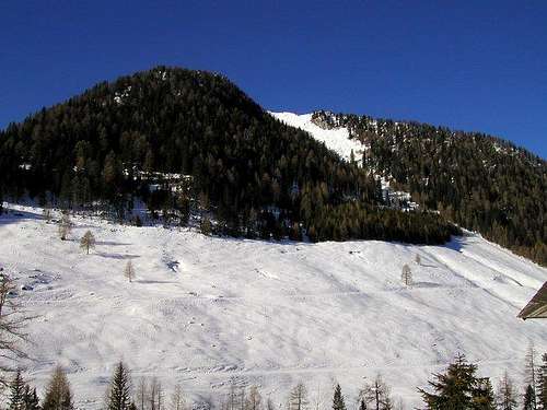
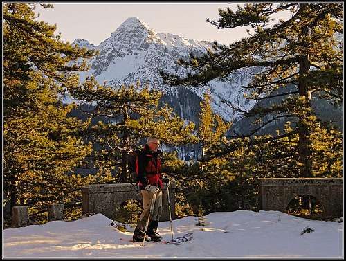
Summit Views

|

|

|
Getting There

For general overview, see the Carnic Alps group page and the Carnic Alps Main Ridge (East) subgroup page.
Northern (Austrian) trailheads are in Gailtal / Ziljska dolina. Driving towards the west from Villach, you reach villages: Vorderberg, Nampolach, Mellach and Moederndorf. In summer, from Moederndorf a road goes southwards and then eastwards on the terrace where Egger Alm and Lake lie. By it you reach the altitude of some 1400 m.
From the southern (Italian) side the best starting point is Valle di Ugovizza (valley), into which we drive from the Udine - Tarvisio - Villach highway from the village of Ugovizza / Ukve. This road is closed for public traffic on the altitude of 1210 m, at Rif. Nordio Deffar (hut). For Monte Cocco, Cima Bella and also Monte Sagran / Sagranberg we start our hike on 1136 m, at Osteria del Camosci, while for Starhand we need to go over the Lom saddle.
On the web, you can see a detailed map on: http://www.austrianmap.at/, but the interactive map below is useful as well.
A very recommendable classical map is: Tabacco: Alpi Giulie Occidentali Tarvisiano, 1:25.000.
Routes Overview
Because of so many forest and cart-roads there is a great variety of possible ascents on Cima Bella and other three summits. Below are just some most convenient.
Monte Cocco, 1941 m
1. From Osteria del Camosci, 1136 m. We hike by forest roads and meadows towards the W and NW. So we ascend the saddle (1815 m) between M. Cocco and Cima Bella. Then towards the south on the summit. This is also a nice and popular ski tour. We can ski down also by the E ridge and later towards the N on meadows. Difficulty: On the SAC ski tours grading scale it is F+.
2. Through Val Rauna. This is a side valley of Val di Ugovizza. A road (closed) deters from the main road over the creek (towards the NW) and into the valley some 2 km before Osteria del Camosci. We follow the road and marks No. 504 until on the altitude of 1400 m on the crossing we choose the right forest road, which goes around the whole mountain and finishes on the altitude of some 1600 m (Col di Mezzo). Then follow the W ridge to the summit.
Many hikers also to the complete round tour around Monte Cocco and aventually also ascend the summit from the N saddle.
Cima Bella / Schoenwipfel, 1911 m
3. From Osteria del Camosci, 1136 m. We go by forest roads and meadows towards the W and NW. So we ascend the saddle (1815 m) between M. Cocco and Cima Bella. Then follow the ridge towards the N to the summit. This is also a nice and popular ski tour. We can ski down almost everywhere. Difficulty: On the SAC ski tours grading scale it is F.
4. From Egger Alm, 1400 m. Go (or drive) till the eastern end of the terrace, to Dellacher Alm, 1365 m. There take the forest road, marked with No. 403, which goes towards the SE, around the E ridge of Poludnik. On the other side, on 1476 m, leave the road and go southwards, crossing the creek, ascend on the other side on the road again and follow it towards the SE (no more marks), all the way to Forcella di Fontana Fredda / Kalten Brunner / Mrzli studenec (saddle), 1692 m. (This saddle can be easilly reached also from the S.) Proceed towards the SW to the summit. Upper parts appropriate for skiing, below are forest roads. The alternative to the E-NE ridge is the route over the Uggowitzer alm and further on the summit by the NW ridge (the so-called Jaegersteig).
Monte Sagran / Sagranberg, 1922 m
5. From Egger Alm, 1400 m. As on route #4 reach the Forcella di Fontana Fredda / Kalten Brunner / Mrzli studenec (saddle), 1692 m. Follow the ridge towards the E to the summit. The upper parts are appropriate for skiing, below are forested slopes. The other option (if coming from the Austrian side) is not to follow the road to the saddle, but to proceed from the point 1425 m (forest hut) towards the E, by marks No. 403. So you reach Goertschacher Alm, proceed to the altitude of 1828 m below Starhand summit, and there turn south and ascend the highest point. The upper parts appropriate for skiing, below are forest roads.
6. From Osteria del Camosci, 1130 m. Like #1 or #3 towards the west, but on the altitude of 1560 m follow the forest road towards the N on the Forcella di Fontana Fredda / Kalten Brunner / Mrzli studenec (saddle), 1692 m. Follow the ridge towards the E to the summit. Difficulty: On the SAC ski tours grading scale it is F.
7. From Sella di Lom / Lomsattel, 1460 m. This saddle between Monte Sagran / Sagranberg and Ojstrnik / Oisternig you can't reach by car. But it can be reached by good marked paths (cart-roads) either from the south (Italy) or north (Austria). From the saddle follow the marked path (Traversata Carnica) No 403 towards the W and later towards the SW to the summit. Difficulty: On the SAC ski tours grading scale it is F+. By the E ridge it is also possible (but not the most beautiful) to ski down from the summit of Monte Sagran on Lom saddle.
Starhand, 1968 m
8. From Egger Alm, 1400 m. As on the route #5 reach the Goertschacher Alm and proceed towards the E on the summit. Also a ski tour.
9. From Sella di Lom / Lomsattel, 1460 m. As on the route #7 go towards the W, but when reaching the S slopes of Starhand follow them towards the N to the summit. If on a ski tour, you can ski from the summit also directly down on Dolinza/Dolinca alpine meadow. Difficulty: On the SAC ski tours grading scale it is PD-.
Monte Stabet, 1630 m
10. From Malborghetto (in Val Canale), 718 m. Till the first traverse you follow the road (closed for public traffic) into Vallone di Malborghetto, on the traverse you deter right and follow the mountain road until it reaches the forested SE ridge of Stabet. Then in a few minutes on top. Some 3 h.
Red Tape
There are no limitations.
When To Climb

Any time of the season.
Camping

These ascents can be normally done in one day. In summer four huts are supporting outdoor activities around our four summits:
Dellacher Alm, 1362 m.
Koutschitzalm, 1100 m.
Starhand hut on Lom saddle, 1460 m, private. Open from mid May or start June till end of October, 7+15 beds, tel.: 04283/2004.
Rifugio Nordio Deffar, 1412 m (south of the Lom saddle). reachable by car.
Books

Guidebook and photomonography (in Slovenian): V. Pogačnik: Kar na Karnijce. Založba Narava, 2011.