
-
 34408 Hits
-
 81.18% Score
-
 13 Votes
|
|
Route |
|---|---|
|
|
0.1512°S / 37.30710°E |
|
|
Trad Climbing |
|
|
Winter |
|
|
One to two days |
|
|
UIAA IV- |
|
|
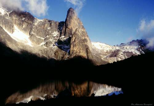
Overview
Punta Nelion Normal route
Mount Kenya, the second mountain in height of the African continent after Kilimanjaro, is located in the namesake complex massif, consisting of various peaks, ridges, imposing spiers and cliffs. The mountain culminates with two main summits, Punta Nelion 5188 m and Punta Batian 5199 m, the highest.

History

The first ascent of Punta Nelion was performed by Eric Shipton and Percy Wyn Harris on 6 January, 1929 climbing this route which is now considered as the standard route. After summiting they descended into the Gates of Mist and then climbed Punta Batian, thus making the second ascent of this summit, which is the highest of Mount Kenya.
Getting there
Mount Kenya is about 200 km north to Nairobi, the capital of Kenya, and is accessible by road by a variety of transport options. Buses, minibuses (matatus), taxi or a hire car will get you to the close to mountain on tarred roads to the nearest town: Nanyuki for Naro Moru and Sirimon routes or Meru for Chogoria route. The last stretch from the nearest town to the various trailheads (typically +/- 25km) will be on dirt roads and these can be in poor condition (especially in wet weather!) and require a 4WD, or an approach on foot.

There are three main trekking routes on Mount Kenya approaching the base of the technical climbing routes and the popular destination of Point Lenana: the Naro Moru route, the Chogoria route and the Sirimon route. The Austrian Hut or Top Hut at 4790 m is the Base Camp for the parties climbing the Nelion Normal Route; the hut can be reached from any of the three routes. Austrian Hut is the highest one on Mount Kenya, with the exception of Howell Hut, a bivouac on Punta Nelion. The Austrian Hut is also a good base for the ascent of Point Lenana, or for exploring the surrounding area. Peaks that can be ascended with Austrian Hut as a base camp include Point Thompson, Point Melhuish and Point John. It is also the starting point for the Normal Route up Nelion, as well as other routes up to the summits.
Naro Moru Route
The Naro Moru Route approaches from the West and KWS have a National Park Gate there and also their main headquarters for the mountain. There is also accommodation available here. This route used to be by far the most popular route as it is relatively short and has huts at Met Station 3050 m and MacKinders 4200 m. However, it has been overtaken by the Sirimon route as the most popular. The huts are good at both locations and they also have camping space. The first day up to Met Station is on a vehicle track through the forest and bamboo. The second day goes through more bamboo and forest before emerging onto the alpine heath and following the Teleki Valley to MacKinders. The forest is still dense on this route, as is the bamboo zone. You are quite likely to see bushbuck, Colobus monkey and Sykes Monkey and also evidence of Buffalo and Elephant. The hygenia forest is also in good condition with a lot of flowers and other plants. The giant heathers above the forest were heavily damaged by a fire in 2013 but the alpine moorland has a lot of Giant Lobelia as well as MacKinders Gladiolus higher up. The Teleki Valley has a lot of the classic Tree and Cabbage Groundsels as well as Lobelia Telekii and Deckenii. Some of the cabbage groundsels in particular absolutely massive.
Route Description

The crux of the climb is UIAA IV-, but most passages are II-III. Under normal conditions there is no or only very little ice. The route is relatively complicated following the most logical, but not a very direct line. It's about 20 pitches long (about 400 vertical meters) From Austrian hut cross the Lewis glacier, scramble up steep scree to the start of the climb ca. 50 m left of a couloir. Climb up ca. 20 m to a terrace, and up a left-leading couloir (donkey walk ca. 25 m). Now traverse back right to some ledges, cross a rib to the base of McInders chimney, and climb down and right (ca. 6m) to a platform below the rabbit hole. Now climb a rib directly right of the rabbit hole (III) and gain a platform via easy rock on top of McInders chimney. One o'clock gully now leads another 40 m up and right. Now climb another ca. 60 m diagonally to the right to gain the S-ridge. Now traverse to McInders gendarm (Bailies Bivvy near the base of the gendarm).
Traverse the gendarm by climbing down 7-10 m and then ascending a couloir to the base of a wall. The easiest and most direct route from here is De Graaf's variation, the crux of the climb. It is a left-facing corner, leading up to a ledge. Now climb up a ridge leading to the amphitheatre and gain a couloir leading up to the summit of Nelion (right from the end of the couloir). Bivvy hut on summit of Nelion. To get to Batian, climb down the ridge leading to the gate of mists. Rappell down ca. 45 m to the gate of mists. leave rope in case the cracks leading back up to Nelion are filled with ice. Traverse round the base of the tower (N-side) and gain the ridge leading to the summit.

Descent: follow the same route, several rappels.
Essential Gear

Normal rock climbing equipment. Double rope useful for rappels and in case the traverse to Batian is planned. Bring own protection (Nuts, Hexes, Camming devices), and several slings (rappels). Crampons and ice-axe may be useful to crossing Lewis glacier, to traversing the Gate of Mists and to climbing Batian.
 |
 |
 |
Red Tape

Mount Kenya is open all the year round. The mountain and the surrounding region are located within a protected natural area, the Mount Kenya National Park. Park fees are payable at the three main park gates, and the current tarifs are available on the Kenya Wildlife Service website.
When to climb
The highest rainfall occurs between late March and the middle of May, and slightly less between late October and mid December. Maximum rainfall occurs in the forest belt and on the south-east side of the mountain where it reaches 2500mm. per year at 3000m. Rain and, higher up, snow can however be encountered at any time of year - even in the driest periods (January and February). Normally the drier seasons are associated with clear, dry weather which can last for many days on end. The best weather is generally in the mornings, and convectional rainfall, if any, tends to come in the mid-afternoon. Temperatures vary considerably with height and with time of day. At 3000m. frosts can be encountered at night while day temperatures range from 5 to 15°C. Night time temperatures on the summit are well below freezing. The south-facing side of Mount Kenya receives more sunshine in the December to March period. During this time rock climbs are "in-condition" and snow and ice climbs gradually deteriorate. In the June to October period the north-facing rock climbs and south-facing ice climbs are best.
Guidebooks and maps
Guide to Mount Kenya and Kilimanjaro by Iain Allan, Mountain Club of Kenya, 1990
Kilimanjaro & Mount Kenya: A Climbing and Trekking Guide by Cameron Burns, Mountaineers Books, 1998
Mt Kenya Map and Guide 1: 50000 by Mark Savage and Andrew Wielochowski, 1998