
|
|
Route |
|---|---|
|
|
40.25500°N / 105.638°W |
|
|
Scramble |
|
|
Most of a day |
|
|
Class 3 |
|
|
Approach
Round trip-11 miles
Vertical gain-3335-ft.
Starting at the Glacier Gorge TH (9,240-ft) hike about .2 miles to the Glacier Gorge Junction, it is signed. You want the “Mills Lake” option, which is to the right. Hike 1.1 miles to another signed trail junction. This is the “North Longs Peak Trail” junction. You want the “Lock Vale” or the “Glacier Gorge” option, which is to the right. Go another .04 miles to another signed trail junction, this is the “Lock Vale/Glacier Gorge” junction, and you obviously want Glacier Gorge. From here, there are no more junctions to worry about and the route becomes obvious. Continue about a half-mile to the beautiful Mills Lake. From here you get your first full view of the gorge area. You can also see Pagoda Mountain from here. Mills Lake is a good half-mile in length and the trail here is easy. Continue hiking past Mills Lake, the next objective is the spectacular Black Lake at 11,100-ft. It is about a mile and a half from Mills Lake to Black Lake. Once you are at Black Lake you will notice 300-ft walls of rock surround the lake. If you look sharp to the left (east) you can pick up the route as it hugs a minor wall of rock that enters the lake. There is a nice ledge here that will take you back to the trail. This trail ascends to the left about .03 miles and will deliver you up to the high basin above Black Lake. Once in the basin you are pretty much on your own. Not that many people go past Black Lake so there are only bits and pieces of trail to look for. From here, The Spearhead towers above you, as well as Pagoda & Chiefs Head and the Keyboard of the Winds. This is a special place.
 |
Route Description
After arriving in “Spearhead Basin”, locate The Spearhead’s north ridge. This is the undefined ridge that separates the vast, unbroken northeast face from the more broken northwest face. Traverse across the upper basin via faint climbers trails to the base of the north ridge. There is a boulder field that surrounds The Spearhead but it’s easy to manage. From the base of the north ridge hike southwest towards Frozen Lake. Do not go all the way to Frozen Lake; instead look sharp for a talus ramp that ascends up through the broken west face. This ramp is tough to miss, plus it has a trail that is easy to identify. Your next objective is to attain the low point or saddle between Chiefs Head and the Spearhead. The west face is mostly steep class 2 with some class 2+ on loose scree and talus. There is better climbing around if you’re into some loose scree, you just have to look for it.
Once you attain the saddle the fun begins. At this point you are only a quarter mile traverse to the actual summit. Traverse north with little or no actual climbing, the traverse consists of easy class 3 climbing. For fun, hike up to the ridge crest and peer down at Green Lake some 900-ft below. There are a few spots that you can actually climb on the ridge crest, but the ridge is festooned with rock pinnacles that bar easy passage. When things get rough just drop down 10-20-ft and continue the traverse. Locating the summit is not difficult, it is the stack of boulders that sweeps up to the sky. Hike up easy class 3 boulders back up to the ridge crest. At this point, there is only one way to the summit block, locate the exposed catwalk and weigh your future. Attaining the summit block requires 10-feet of angled catwalk, approximately 2-ft wide with precipitous drop-offs on both sides and in front. Walk the catwalk to a small notch where two large, flat boulders come together to form the summit. Pull yourself onto either boulder and The Spearhead is yours.
Essential Gear
Wear a helmet, the west face is somewhat steep and loose and rockfall could be an issue, especially if there are other parties above you.
brenta - Sep 12, 2004 8:05 pm - Hasn't voted
Route CommentI just came back from Spearhead's Northwest slopes. Excellent hike/climb. Directly as we caught sight of Frozen Lake, we saw a prominent talus ramp on our left. We followed it to the ridge, but instead of reaching its low point , we ended up much closer to the summit.
It looked like we should have continued to another ramp, South of the one we took, to do the entire ridge. We were planning some investigation on the way down, but then the wind picked up and the sky threatened rain (which didn't come), so that we more or less descended the ascent route.
Reading Roach's description, it seems that we may have followed the "variation" to the Northwest slopes: faster and a little harder than the base route, but probably less scenic. I have trouble, however, reconciling our experience with the description of the route here on SP. Besides, Roach's desciption of the variation does not refer to a ramp. Can anyone shed some light on this little mystery? Thanks in advance.
brenta - Sep 14, 2004 3:36 am - Hasn't voted
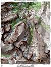
Route CommentThe photo should clarify what the two lines are:
1. The yellow is the one we followed
2. The red line is the one that should reach the Chiefs Head-Spearhead saddle.
Nelson - Sep 26, 2004 3:43 pm - Hasn't voted
Route CommentI have climbed this side of the Spearhead 4 times (once in each season!) and have always taken the yellow line. In spring and winter it was filled with nice consolidated snow, at least down below, which made that lower part an obvious choice. Kane's red line looks like a great variation to cover the upper ridge. That would be fun. Maybe next time!
timwebb - Jun 22, 2012 2:33 pm - Hasn't voted
Re: Route Commentwe did the same route you did....seems natural..easy to see....do not think ridge lower much more "pretty", so i think you picked best way