Getting There
![South Taconic Trailhead]() South Taconic Trail.
South Taconic Trail.The South Taconic Trail route can be accessed in the Dutchess County, New York Town of North East. To reach the trailhead, take New York State Route 22 to the intersection with White House Crossing Road in the Columbia County Town of Ancram. This point is about 11.3 miles south of NY State Route 23 and 5.4 miles north of the NY Route 44/22 split in Millerton. Proceed east on White House Crossing Road 6/10 of a mile to the intersection with Boston Corners Road and turn left (north). A quick right onto the upscale residential Deer Run Road will lead you to Quarry Hill Road in another 4/10 of a mile. The trailhead is located on the east (left) side of Quarry Hill Road just before it dead-ends.
Trail Description
The trailhead sits at an elevation of about 950 feet or about 1,500 feet lower than the 2,453-foot summit of Mount Frissell. The South Taconic Trail is truly an under-rated trail in the equally under-rated Riga Plateau region, which runs along the New York State border with Connecticut and Massachusetts. From the trailhead, the white-blazed South Taconic Trail ascends moderately to steeply to the east, paralleling an unnamed stream which is never too far out of earshot. Within the first mile of hiking, you attain an elevation of 1,800 feet and reach a minor trail crossing. At the crossing, continue on the white-blazed South Taconic Trail, which turns left and to the north. The trail ascends more gently from here and in another 3/4 of a mile reaches the top of the 2,304-foot South Brace Mountain, from which outstanding views of the low-lying New York State farmland can be viewed. The hiker now descends no more than 100 feet before climbing back up to the 2,311-foot summit of Brace Mountain. Continuing north, an ATV trail soon intersects the trail from the east. Do not take this trail. Instead, continue another 2/10 of a mile to the intersection with the red-marked Mount Frissell Trail, where you turn right (east) and slightly downhill. At this point, you will have hiked only about 2 miles from the trailhead (all in NY). From here, hike east on the red-blazed trail to the NY/CT/MA tri-corner marker in another half of a mile. It is just after this point that you begin to ascend the final few hundred feet to Mount Frissell's 2,453-foot summit (located in Massachusetts), passing the 2,380-foot highpoint of Connecticut along the way. The highpoint is marked by a small green stake on the north side of the trail. At the actual summit, there is a summit register. Total hiking distance from the trailhead is only about 3 miles, but you get a lot of bang for the buck. Highly recommended is the New York/New Jersey Trail Conference "South Taconic Trails" map. It can be obtained for $4.95 through the
NYNJTC.
![South Taconic View]() Looking west to NY State farmland.
Looking west to NY State farmland.Essential Gear
No special equipment required.

 15926 Hits
 74.01% Score
 4 Votes
 South Taconic Trail.
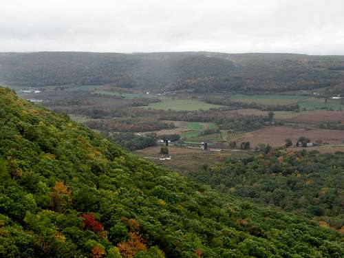 Looking west to NY State farmland.