

-
 45727 Hits
-
 97.54% Score
-
 70 Votes
|
|
Area/Range |
|---|---|
|
|
37.74847°N / 105.5324°W |
|
|
Hiking |
|
|
Spring, Summer, Fall, Winter |
|
|
Overview
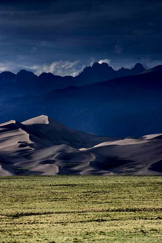
The Crestone Peaks loom over the Great Sand Dunes
photo by Mark Doiron
photo by Mark Doiron
Some of the most unique features of the Sangre de Cristos aren't mountains of glaciated rock but rather heaps of wind-obliterated peaks. The Great Sand Dunes National Park and Preserve is one of the most popular destinations in the San Luis Valley, and their abode beneath the towering mountains means that a first visit to the park often coincides with one's first exposure to the Sangre de Cristos' majesty. The stunning contrast between the desert-like conditions of the dunes and snow-capped mountains just a few miles away creates one of the world's most picturesque locales.
The Great Sand Dunes are North America's tallest, reaching heights of 750 feet above the valley floor. Another 350 feet of sand lies below the valley floor! By comparison, the world's tallest dunes, in China's Gobi Desert, rise just 450 feet taller. It is perhaps not apt to compare them to some of the earth's other large dune fields, however, because the Great Sand Dunes' five-billion cubic yards are so compact that some geologists consider them to be a single, large dune. Whereas other major dune fields have large, flat areas in their midst, the Great Sand Dunes feature continuous rolling dunes throughout their expanse.
The highest dune in the park, High Dune, lies at an elevation of 8,691 feet, and is a popular hiking destination. By Colorado's standard, the 300-foot rule, High Dune is a ranked Colorado peak. Another common destination for visitors of the park is Star Dune (8,617'). While its elevation is lower than High Dune, because the valley's floor slopes downward from east to west, Star Dune rises 100 feet higher off the valley floor and is referred to by the Park Service as the tallest dune in the park. Far more obscure is the second ranked peak in the dune field, Dune 8860, which lies west of Castle Creek's confluence with Medano Creek.
The Great Sand Dunes' fauna are as diverse and unique as the ecosystem they call home. Kangaroo rats, short-horned lizards, pronghorns, and jack rabbits -- and even a few endemic species of insects, like the Great Sand Dunes tiger beetle -- inhabit the dunes and the surrounding prarie. Sandhill cranes, leopard frogs, beavers, avocets, and white-faced ibis reside in the wetlands west of the dunes. All this, coupled with the typical assortment of alpine and sylvan creatures in the higher terrain of the Preserve, makes the Great Sand Dunes National Park and Preserve one of the most biologically diverse places in Colorado.
Geology
The Great Sand Dunes' creation goes back to about 12,000 years ago when the last Ice Age ended. In the San Juan Mountains, sand that had been ground down by glaciers and trapped in ice during that frigid period was now freed, allowing the prevailing winds from the west and southwest to carry the sand particles across the San Luis Valley. The winds have continued to erode the San Juans, creating additional fodder for the dunes. The Sangre de Cristos lie uncharacteristically low between Medano and Mosca Passes, and consequently, the wind funnels through this area of lesser topography and on to the east. However, even this lower section of the Sangres rises over three thousand feet above the valley floor. Before the winds can travel up and over the range, they must release their burden of heavy sand, resulting in the accumulation and creation of the Great Sand Dunes in the crook of the Sangres between the Mount Herard massif and the Sierra Blanca.The winds pick up sand from another source outside of the San Juans. Following the end of the Ice Age, the San Luis Valley became more arid. It is now the only true desert in Colorado's Rockies, with rainfall amounts averaging only 8 inches each year. The once lush San Luis Valley dried out even to the point that the northern half of the valley became a closed basin. Water draining from the western side of the Sangres' core never reaches the Rio Grande River. Instead, the water that doesn't simply evaporate delves deep into the sand and gravel floor of the valley, creating aquifers. Farmers in the valley, in order to irrigate their lands, have tapped into these deep sources of water by digging numerous artesian wells. Because of these exceedingly dry conditions, over time the winds have picked up topsoil from the valley's floor, contributing further to the Great Sand Dunes lofty heights.
 Magnetite forms natural patterns in the sand
According to Roadside Geology of Colorado, the sand of the dune fields is composed of "rounded grains of quartz and of volcanic rock," betraying their origins in the San Juans. Thus, visitors to the dunes see sand of a darker color than is found in most other dune fields and beaches.
Interestingly, and perhaps counterintuitively, the Great Sand Dunes' shape hasn't changed much over the last hundred years. Comparing old photos with new ones reveals that the dunes' main ridges have moved very little relative to the dune field. It is believed this is because the prevailing winds out of the southwest are sometimes balanced by winds that bounce off the Sangres and swirl back toward the dunes, as well as by winds that channel over the mountains from the southeast. These leaves one to wonder, "How long will they remain in equilibrium?" and to that question, even the experts have no answer. The dune field's boundaries are presently stablized by the creeks that border them. Each spring, when snowmelt brings their flow to a peak, Sand and Medano Creeks carve the dunes back, leaving low sand cliffs, which eventually collapse under their own weight. Another interesting fact related to the creeks is that much of their flow actually seeps through the dunes.
A visit to the park during spring snowmelt provides an introduction to another fascinating aspect of the dune fields: surge-flow. Because the creekbeds are sandy and wide, the water depth is relatively thin. Consequently, small rises in the sand's surface are enough to block water flow. Once the pent-up water rises high enough, it breaks over the sand's temporary dam in a surge, creating small waves. The sandy shores coupled with surge-flow can lend a distinctly beach-like feel to Medano Creek.
History
Zebulon Pike, for whom Pikes Peak is named, was the first American to document a sighting of the Great Sand Dunes during his exploration of the recently acquired Louisiana Purchase. After crossing the Wet Mountains and the Wet Mountain Valley, Pike led his men into the Sangre de Cristos for a winter traverse of the range. As they pressed on through waist-deep snow, nine of Pike's fourteen men were frostbitten, and he was forced to leave three of them behind. On January 28, 1807, they crossed over either Medano or Mosca Pass and down into the San Luis Valley. In the style of the day he wrote, "The sand hills extended up and down at the foot of the White mountains, about fifteen miles and appeared to be about five miles in width. Their appearance was exactly that of a sea in a storm (except for color) not the least sign of vegetation thereon."From a camp near Medano Creek, Pike climbed one of the largest sand dunes, and from the summit he descried a large river. He believed he had found the Red River, which would have been a part of the Louisiana Purchase. Of course in reality, he had located the Rio Grande and was trespassing on Spanish land. Soon after, Spanish soliders captured Pike and his remaining men and led them to Chihuahua, Mexico and confiscated his papers. Although Pike and his men were not mistreated -- and Pike himself was permitted to return to the United States after four months -- five of his men were held in Mexico for two years!
More recently in 1932, members of the Monte Vista chapter of the Philanthropic and Educational Organization for Women (PEO) sponsored a bill requesting National Monument status for the Great Sand Dunes. The bill passed Congress that same year, and was signed into law by President Herbert Hoover, protecting the 38,000 acres of the main dune field and its immediate surroundings for the first time.
In 2000, Congressional legislation was passed to upgrade the area to national park status. However, the park's official designation was contingent upon the completion of a complex set of land purchases and transfers. Primary among these was the 31-million-dollar purchase of the Baca Ranch by The Nature Conservancy (TNC), and the subsequent donation of much of that land to the federal government. This was an important piece of the puzzle because the landowners previously had sought to develop the aquifers on the ranch for commercial purposes. The water resources of the area are an essential component of the dunes system (see Geology), the full implications of which weren't uncovered until the 1990s, so this is the chief reason that national park status was withheld until the landholders and TNC could broker the deal for the Baca Ranch. Finally, in 2004 the purchase was completed, and the Great Sand Dunes became a National Park.
As part of this new designation, over 46,000 acres of Forest Service land in the Sangre de Cristo Mountains was transferred into the hands of the National Park Service, becoming the Great Sand Dunes National Preserve. Most of this area, which includes a number a beautiful 13ers, is defined by the watershed boundaries of Sand and Medano Creeks. The highest peak in the preserve is Tijeras Peak (13,604'). Most of this 46,000 acres had been previously established as part of the Sangre de Cristo Wilderness in 1993. Additionally, Rio Grande National Forest gained 13,599 acres of land through this transaction, which officially added the 14er Kit Carson Mountain to public lands. In addition to all this, 92,617 acres of the Baca Grant was transferred to the U.S. Fish and Wildlife Service, creating the Baca National Wildlife Refuge. TNC continues to manage the Medano and Zapata Ranches west of the national park as working bison ranches; over 1000 head roam these areas.
Recreation
Beyond exploring the dunes on foot and taking in the incredible and unique scenery, there are a number of other activities that people enjoy when they come to the Great Sand Dunes. Some like the challenge of four-wheel-driving Medano Pass Road. Be prepared for this one because people have gotten stuck on this sandy road! Other activities include horseback riding and mountain biking, and there are several public hot springs nearby, including the Hooper Pool (a.k.a. Great Sand Dunes Pool) west of the park.One of the most unique activities that some people partake in at the dunes is dune-skiing or sandboarding! According to Charlie and Diane Winger's book, if this is something you want to try, "it is very important to thoroughly remove all wax from the bottom of [your] skis before trying to slide on the sand. Silicon spray or WD-40, liberally applied, [makes] the run down the sand slope feel a lot more like a run down a groomed snow slope." I presume this would be fun when the dunes have a covering of snow, as well!
Red Tape
This is from the Park Service: "The Baca district of the park is relatively undeveloped and wild, with dramatic views of the Crestone Peaks and the Sangre de Cristo Mountains. Access to this area of the national park is currently open to limited backcountry use. Please inquire at the Visitor Center, 719-378-6399, for current access information."External Links
Official Great Sand Dunes NP websitePark Service maps
Sources
Halka Chronic & Felicie Williams – Roadside Geology of Colorado
Jason Moore – Hiking Colorado's Sangre de Cristo Wilderness
Charlie & Diane Winger – The Essential Guide to Great Sand Dunes National Park & Preserve
Too many images!
We have over 80 pictures of the Sand Dunes currently on this page, covering multiple angles and a variety of subject matter. I monitor submissions to keep the total number of pictures at a reasonable level. If you're thinking about submitting images to the Great Sand Dunes page, please check your pics against the ones currently posted and ask yourself the following questions:-- Does your photo show something new that isn't represented?
-- Is your photo unique and captivating?
-- Is your picture nicely composed?
-- Is your photo the product of a digital camera or a high-quality scan?
If you can't answer yes to most of these questions, please consider posting your pictures elsewhere, perhaps as companions to a Trip Report.
Thank you!
DudeThatMustHurt - Jul 14, 2006 11:40 pm - Hasn't voted
Surge FlowGreat Sand Dunes National Park. Medano Creek. Home of the largest sight of "Surge Flow" in North America, created by a phenomenon called “Antidunes” this is where the sand from the Dunes builds up as an underwater damn and when enough pressure behind it has formed the damn bursts and can create wakes as high as one foot. At the Great Sand Dunes NP this occurrence happens approximately ever 15 to 30 seconds year round. An interesting sight to be seen and also very fun to play in on a hot summer day. Spring and Summer are the best times to view this phenomenon.