The page was successfully edited.

|
|
Route |
|---|---|
|
|
40.87270°N / 107.0381°W |
|
|
Mountaineering |
|
|
Spring, Winter |
|
|
One to two days |
|
|
Class 3 |
|
|
Class 3 snow in winter |
|
|
1 |
|
|
Overview
This is probably the easiest route up Nipple Peak in winter. The route is 13 miles round trip and will be a very long day in winter. You should take a headlamp and get a very early morning start. The climb could be done as an overnighter as well.
Note: We did this route in winter. The route description will be described as a winter route since that is how we climbed the peak. I will climb the mountain this summer, and will add more to the page.
 |
 |
 |
Skies versus Snowshoes?
You may wonder if this route is better on skies or snowshoes. Here’s the rundown. Steamboat Climber took skies, I took snowshoes. Skies were much faster all the way to the ridgeline. Once we hit the ridgeline, it was tough to climb the mountain on skies, and pretty tough with snowshoes. Steamboat climber removed his skies, and I broke trail with snowshoes. The final section of the peak requires an ice axe, and trying to climb it on skies seems near impossible.
To sum it up, skies are faster and easier for most of the route, but snowshoes are easy for the later 4/5 of the route.
Getting There
From Steamboat Springs, drive to the north end of town and to where County Road 129 leaves Highway 40. A sign marks "Clark" and "Hahns Peak". This is the same road heading to the airport. Follow County Road 129 north for about 29 miles, past the small town of Hahns Peak, and to the north to Tribly Creek. This trailhead is half way between the turnoff to Hahns Peak Lake and Columbine and is located on the west side of the road. In winter you will park here. In summer, this is Forest Road 488.
Summer note: FR 488 is an excellent road except for the last mile or so and then it is more of a jeep trail.- SP member Vanny37 from June 2007.
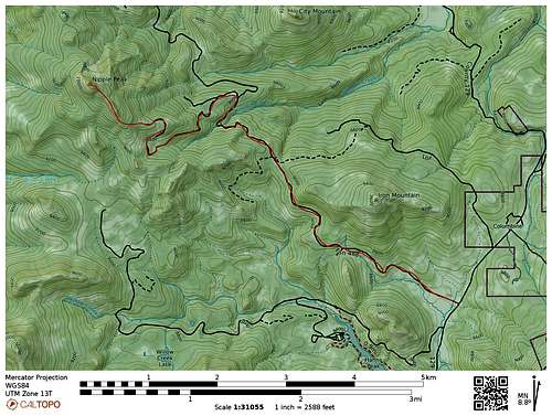
Route Description
From Tribly Flats, ski or snowshoe the road grade to the west. The road grade climbs gently around Iron Mountain and reaches a pass.
Continue along the road around the north facing slopes of a ridge. You will get some teaser glimpses of Nipple Peak ahead.
The road then descends slightly to Sawmill Creek, and takes a sharp turn to the north. The road makes a really long loop around, so you may just want to shortcut (see map) and climb up the slopes to the west, instead of following the road all the way around. The going is a bit tough, but faster.
When you reach the road again, follow it west to an open area. I assume the road isn’t drivable in summer at this time, because it appears very narrow and has some trees growing on it. From the open area, forget about the old logging track, as it is a very long roundabout route, and just head southwest to the ridge.
One the ridge is reached, follow it northwest to the summit. The first tough part (in winter) is reaching the 10,100 foot sub-peak/false summit. In deep snow, it is hard to push a route up it. Bear with it to the sub-peak. Once you are at the sub-peak, the really spectacular views begin to unfold.
You will see the true summit up ahead. In winter, and with deep snows, it is more-or-less impossible, or at least really difficult, to climb the final pitch without an ice axe. With an ice axe, the route should be pretty easy. In summer the route is said to be only class 3.
Note: In winter, the final pitch requires an ice axe. We left our ice axes in the car, not expecting the mountains to be so rugged. I could not make the final pitch in snowshoes and without an ice axe, and with ski poles, so I missed the summit by 200 vertical feet, though we could see all of the rest of the route.
See Vanny's description for a summer description on one route up the final pitch:
Final Pitch via Northeast Face
There is also a class 2 (or 3) scree walk to the summit on the south face of the peak.
 |
 |
 |
Essential Gear
An ice axe, and possibly crampons are needed in winter. See the above section for skies vs snowshoes. Bring a headlamp!
External Links
No links. This route is only on Summitpost!!!