
-
 55243 Hits
-
 94.05% Score
-
 46 Votes
|
|
Mountain/Rock |
|---|---|
|
|
48.16000°N / 24.49940°E |
|
|
Hiking |
|
|
Spring, Summer, Fall, Winter |
|
|
6762 ft / 2061 m |
|
|
Overview
Ukrainian: Говерла/Goverla
Polish: Howerla
Hungarian: Hóvár
Czech: Hoverla
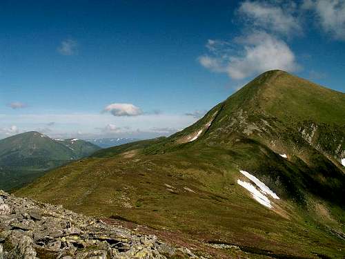 Hoverla (2061m) - Ukraine's highest mountain
The highest mountain of Ukraine and the highest peak of Chornohora Range, in the Northeastern Carpathians.
History
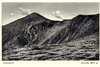 Vintage postcard
Since the fall of communist regime in Eastern Europe, when borders became more open, the whole beautiful area of the highest part of Ukrainian Carpathians attracts attention not only of Ukrainian tourists but nowadays becomes more and more popular among hikers from other close countries especially Poland, Czech Republic and Slovakia for whom visiting Eastern Carpathian mountians is a real sentimental "back to the past" journey!
The main ridge of the Eastern Carpathians (which includes Hoverla) used to be a borderline. For a long time until the end of World War 1 it separated Galicia (area inhabited mainly by Polish, formerly Poland, later under Austrian rule) and the Kingdom of Hungary. After WW1 the border stayed in place, but the countries have changed: the whole area of present western Ukraine was divided between Poland (east from the main ridge) and Czechoslovakia (west from the main ridge). In 1938 and 1939 the western part was re-annected by Hungary until the end of WW2, when the complete region was snapped to the Soviet Union. Since the disassemble of the SU, the territory belongs to present day Ukraine. However, most of the characterstic granite border posts have remained in place along the whole ridge (a good guide for trekkers in fog) and the ruins of the Polish Astronomical Observatory on the summit of Pip Ivan/Pop Ivan peak (2028m) also remind old times.
Nature conservation and tourism
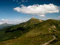 On the main ridge trail towards Hoverla
Wonderful nature of the area is protected by Karpats'kyi National Park - the first national park in Ukraine organized in 1980 and the Karpats'kyi Biosphere Reserve (southern slopes of the massif). The unique Central European forests, sub-alpine and alpine ecosystems with mixed beech-fir-spruce and pure spruce forests can be found in the park. The park also contains health resorts, lodges, sport facilities, architectural and historical monuments, and archeological sites.
The date of the first ascent on Hoverla is unknown. In late 19th century the mountain became a notable tourist attraction, especially among tourists from nearby cities of Galicia. In 1880 the first tourist route between the peak of Hoverla and Krasny Luh was marked by Leopold Wajgel of the Galician Tatra Society. The following year the first tourist shelter was founded there.
The name of the peak
by yatsek and peterbudThe name of this peak is a mystery. For centuries, the region was one of the most ethnically varied of all in the Carpathians (see this SP article). Most Polish guidebooks and websites read that "Howerla" derives from a Romanian word which meant "difficult to pass". But the problem is that neither Romanian nor Ukrainian people cannot recognize anything familiar within this word whereas Ukrainian legends point to the Hungarian word for snow, namely hó, being the root of the word "hoverla". Reference to the peak being snowcapped longer than its neighbors seems highly likely.
And Hungarians have lived in the area for about a thousand years. In fact, they are believed to have crossed the Carpathians through the nearby "Verecke Pass" about a millennium ago. Old Hungarian toponyms, such as Borkut or Hedje, can still be recognized in the area. From the town of Kőrösmező (now Yasinya), Hoverla is seen very well and it just seems impossible for such a landmark not to have been named for ages.
 Hoverla seen from Yasinya(Kőrösmező)
 1780's: Howirliu
On some maps made in Poland in C18, there is a mountain named Śnieżna Góra (Snowy Mtn). There are a number of schneebergs all over Central Europe. Today's Hungarian name of the summit is Hóvár, which translates as Snowy Fort/Castle but "Hóvár" is said to be invented in the first half of the last century. Stanislaw Staszic, Polish writer and geologist who visited the area in 1815, only records two toponyms: "Piatros" and "Czarna hora".
Obviously "Hoverla" must have been coined on the Hungarian side. At about the same time a Kowerla shows up in an article in The Times (London) as well as on the Austro-Hungarian maps, notorious for errors made while covering areas inhabited by people who spoke Slavonic languages. "Koverla" would be used in the West and later in Czechoslovakia until mid-C20. But the first KuK (Kaiserlich und Königlich Militaergeografisches Institut) map issued in the 1780's shows Hoverla as "Howirliu". Józef Haliczer in his geographic dictionary published in 1935 pointed at the possibility that the word Hoverla may have German ("Saxon") roots (there is e.g. the Vaser River in the nearby Marmarosh Mountains, originating from the German "Wasser", meaning water) and may have meant "hill/summit". This theory cannot be ruled out either.
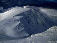
 The snowy peak
 1820's: Kowerla
Throughout the Carpathians, mountains often take their name from a settlement at their foot or/and a creek rising on their slopes, Gerlach (the Carpathians' highest summit) being the most spectacular example. The Austrian (later Austro-Hungarian) cartographers who conducted the first epic survey of the lands within the borders of the empire in the second half of C18, then another in the first half of C19 and finally the third at the beginning of C20 needed to name plenty of unnamed summits.
It was then that a number of Carpathian mountains were named after a nearby village or stream, or a pasture on their slopes. (Breskul, a secondary summit SE of Hoverla took its today's name from the polonyna on the southern slopes of the massif). But just recently a revelatory 1725 map has shown up on the Internet (zoomable version here) which proves that the name of the highest Chornohora's peak is at least three centuries old. This map features a clear Hoverle on the then-Polish border as well as a stream called Hoverlecz which means that the stream was named after the mountain, not the other way round.
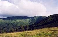
Chornohora Range
Chornohora (Black Mountains)
The highest mountain group in the Ukrainian Carpathians, the eastern part of the Polonynian Beskyd. Its main range extends for about 40 km from the Chorna Tysa River in the west to the Chornyi Cheremosh River in the east. Chornohora is built of hard sandstone with strata of low-resistance schist. The major part of Chornohora forms the watershed between the Prut River and the Tysa/Tisza River. For many centuries this was also the boundary of the states to which Galicia and Transcarpathia belonged. The western part of Chornohora, containing the Petros Peak (2020 m), lies in Transcarpathia in the basin of the Tysa river. The two parts of Chornohora are separated by a deep pass (alt 1550 m).
 Chornohora - Eastern Carpathians
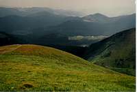 Chornahora from slopes of Hoverla
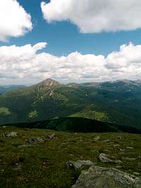
The western part of Chornohora is heavily gouged (the relative height of Petros is 300 m). The eastern part is a massive, monotonous range with peaks over 1900 m high: Hoverla (2061); Shpytsi, (1997); Tomnatyk (2018); Pip Ivan (2026) and a minimum elevation of 1750 m. Short ranges branch off from the main range. The slopes of Chornohora, which are dissected by narrow valleys 1000 m or more in width, contrast with the almost level ranges, which are the remains of former peneplains.
The landscape of Chornohora has been affected by glaciers more than has that of other parts of the Ukrainian Carpathians. In the Ice Age the boundary of permanent snow lay at an elevation of 1300-1400 m, and short glaciers formed at the sources of streams. In the Prut River Valley the glacier reached an elevation of 1000 m and was 6.5 km long. Postglacial depressions, with steep, often rocky slopes and broad bottoms sometimes covered with lakes (mostly under Tomnatyk) or peat bogs, the uneven slope of the valleys with occasional waterfalls (on the Prut River, for example), and lateral and terminal moraines are some of the effects of former glaciation.
 The main ridge of Chornahora
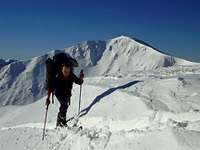 ski-touring on the main ridge
The slopes of Chornohora are covered with forests, which occupy 70 percent of the surface. Beech trees are found on the northern slopes in the lower forest belt up to 1300 m, and spruce trees appear higher up (even up to 1600 m). Beech are also common on the southern slopes and they constitute the upper boundary of the forests. Above the forest belt , up to 1800 m, lies a belt of alder and juniper brush, and above it a belt of clear mountain meadow that reaches the peaks or ends sometimes at stone fields. There are many endemic species of flora.
The local population consists mainly of the Hutsul ethnographic group, which inhabits the lowest parts of Chornohora: in Transcarpathia (Zakarpattya) Yasinia lies in the Chorna (Black) Tysa River Valley and the town of Bohdan in the Bila (White) Tysa River Valley; in the north there are only the villages of Bystrytsia and Dzembronia. Arable land covers scarcely 0.5 percent of the surface area; forests, 70 percent; hayfields, 5 percent; meadows and pastures, 22 percent. To protect the soil and the villages from floods, small reservoirs were built after the First World War. In 1964 a preserve of 7,702 ha was created in the region; it now forms part of the Carpathian Nature Reserve.
Herding is an important occupation in Chornohora, where the pasturing season lasts for five months. The main industry of the Ukrainian Carpathian Mountains is tourism. Its centers include Rakhiv, Yasinia, Vorokhta, Bystrets, and Verkhovyna (formerly Zhabie) .
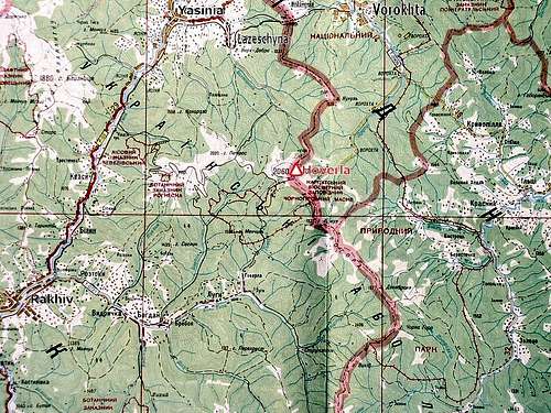
Getting There
Good communication links in the area via major towns of Western Ukraine, first of all nearby Ivano-Frankivsk and then Lviv City, Chernivtsi and Uzhorod.
Railway Lviv-Ivano-Frankivsk-Chernivtsi and Ivano-Frankivsk-Rakhiv
Coming from Poland: via Lviv
Coming from Slovakia or Hungary: via Uzhorod
Coming from Romania: via Chernivtsi or Rakhiv
Russian and Ukrainian Railway Connection Search (in English)
Ukrainian Railways (in English)
Ukrainian Bus Connection Search
Remember! Ukraine lays in Eastern European Time Zone (GMT+2)
Routes Overview

 Main ridge
Hoverla is not a difficult mountain to climb. By far the most popular route is from the east - a 6 km climb one way from a trailhead at 1100 m above sea level (Zaroslyak mountain chalet). It costs a few hryvnias to enter the nature reserve at the end of the very bad gravel road from Vorokhta.
The trail starts at Zaroslyak chalet and rises through spruce forests that open up at 1400 m to reveal beautiful meadows. Grazing here is forbidden, so the grasses and wildflowers grow tall. There is a small spring at the beginning of the meadows where you can fill up your water bottle. The treeline is around 1600 m, but dwarf junipers grow as high as 1800 m.
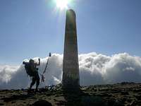
The summit of Hoverla offers excellent views in all directions on rare sunny days. It is surrounded by other mountains above 1800 m. Patches of snow often remain through August. There are a number of monuments on the summit.Another less popular but nice route up Hoverla is from the north - about 12 km. starting at the extreme south end of Lazeschyna village (seasonal Kozmeschyk tourist base camp).
 The summit
In my opinion the best choice when planning climbing Hoverla Peak is taking a 2-3 day trip by the whole length of beautiful Chornohora ridge (with bivouacs) starting in the small village of Dzembronia (Berestechko) situated under under peaks of Smotrec (1894) and Pip Ivan (2028) at the sout-eastern end of the massif.
The village is accessible in the summer season by numerous mini-buses from Verkhovyna. The ridge route is just an easy hike by the highest summits of Ukrainian Carpathians, wonderful views in all directions. The trail is not marked but the orientation is not complicated: you just have to keep the path going by the ridge following the old border-posts, or traversing grassy slopes just below.
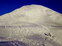
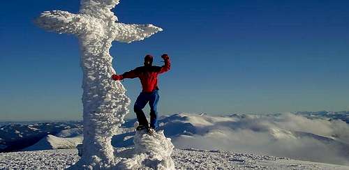 Hoverla summit in winter
Maps
The following recently published hiking maps are available:
1:50,000 map of Svidovets, Chornahora and Rakhivsky Mountains by Szarvas
with Ukrainian and Hungarian toponyms
2nd edition published in 2009 - a low-res version is available online.
1:60,000 map of Chornohora by Ruthenus
with Polish toponyms
1st edition published in 2010 - see a sample of the Howerla area
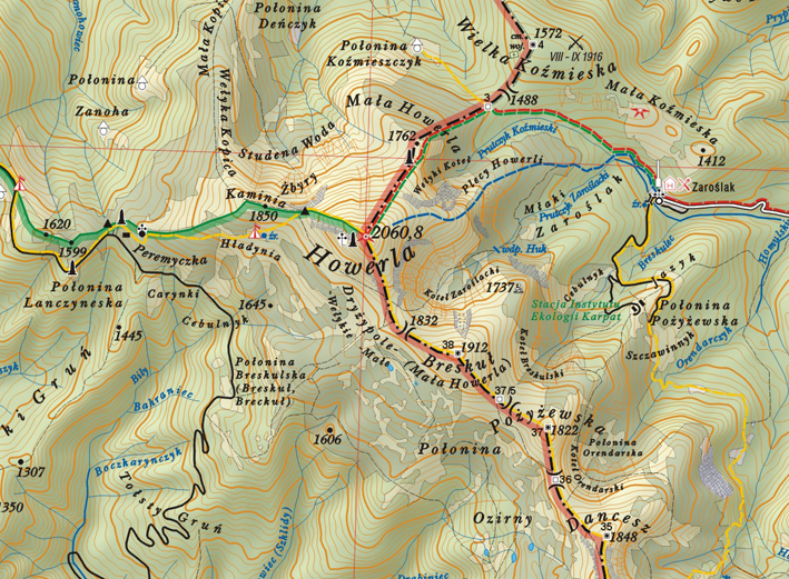
 Hoverla peak area - excerpt from an older map
Red Tape
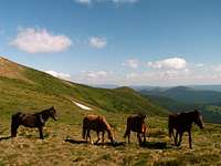 Horses
It is Carpathian National Park and Carpathian Biosphere Reserve area.
There are some small entry fees on the main Hoverla summit route from Vorokhta through Zaroslyak.
Stay always respectful to mountain nature!!!
Follow the rules of wildlife conservation!
Don't leave any rubbish at camping places in the mountains...
When To Climb
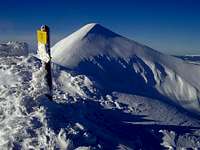 Hoverla in winter
You can hike in the area for the whole year.
Best time: August to October
June/July : frequent thunderstorms, heavy rainfall periods and foggy weather.
Great ski touring area.
In winter usually serious avalanche danger!
Mountain Conditions
Severe and extremely changeable Carpathian climate - be always prepared for sudden weather breakdowns!
See weather report for Ivano-Frankivsk airport.
Camping
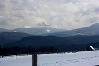
 Hoverla in cloud, from Lazeschyna Valley
Huge tourist accomodation possibilities in the mountain villages (usually in private houses) like Vorokhta (major tourist centre of Chornohora Mtns.), Verkhovyna, Yaremche, Yasinia or others ...
Higher in the mountains there is only one mountain chalet - Zaroslyak - on the most popular summit route to Hoverla Peak going from Vorokhta.
While camping is not allowed on the east side of Hoverla, it is not forbidden on the west side, where horses and cattle also roam.
Drahobrat resort - 18 km from Yasinya (more on accommodations)
Chatka u Kuby tourist hut in Dzembronia
External Links
- Ukrainian Carpathians (Cyrillic script)
- Ukrainian-Polish Tourist portal
palic - Aug 15, 2007 7:12 am - Hasn't voted
Photos from trips to UkrainaI was twice in this area in summer time - photos and articles (in CZ only) are here: Ukraina - Hoverla and around in 2007 http://www.ho-vsetin.com/view.php?cisloclanku=2007073001 Ukraina - Hoverla and around in 2006 http://www.ho-vsetin.com/view.php?cisloclanku=2006083101 BTW, 2026m of Pop Ivan is including the tower of former weather station?
yatsek - Jul 12, 2009 4:24 am - Voted 10/10
Great Carpathian Epic Available OnlineUnfortunately, only in Polish
Tomek Lodowy - Jul 12, 2009 5:37 pm - Hasn't voted
Re: Great Carpathian Epic Available OnlineThanks Yatsek ! There were times when I was strongly looking for that! As I see everything is there! Thanks a million ! Pozdrowienia z Wyspy Tomek
yatsek - Jul 13, 2009 6:12 am - Voted 10/10
Re: Great Carpathian Epic Available OnlineThe funny thing is I couldn't find it while I was looking for it, just came across it by chance yesterday. Przyjemnej lektury! Jacek
yAnTar - Oct 12, 2014 4:30 pm - Hasn't voted
timetablesPlease change URL to timetables to correct - http://www.uz.gov.ua/en/passengers/timetables/
peterbud - Dec 1, 2014 2:49 am - Voted 10/10
Re: timetablesDone, thanks a lot for the information!