
-
 7952 Hits
-
 81.56% Score
-
 14 Votes
|
|
Mountain/Rock |
|---|---|
|
|
49.15301°N / 7.77399°E |
|
|
Hiking, Sport Climbing, Toprope, Bouldering |
|
|
Spring, Summer, Fall, Winter |
|
|
850 ft / 259 m |
|
|
Overview
The Town of Dahn
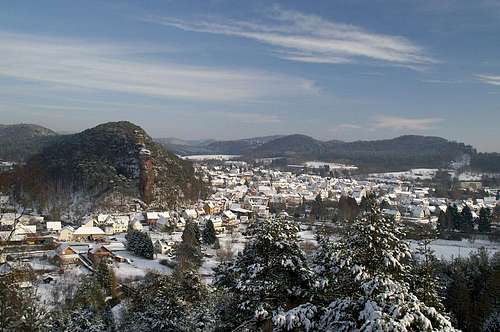 Jungfernsprung and Dahn seen across the Wieslauter Valley from Jakobsfels Jungfernsprung and Dahn seen across the Wieslauter Valley from Jakobsfels |
The town of Dahn, which is located at the centre of the Wasgau region in the south-west of Germany, is best known for its many castles. Three castle ruins - Altdahn, Grafendahn and Tanstein - can be visited to the south-west of the town while to the north you can find Neudahn castle, a massive building, overlooking the Wieslauter Valley. However, Dahn also is very popular among climbers and thus can be called the climbing capital of the whole Wasgau region. The town is surrounded by numerous climbing crags, all made up of red sandstone, which can be reached by 15 minute walks from the town centre. Spare a look at the little map below, which shows the most prominent of the not bothering with boulders or unnamed rocks.
The Cliff
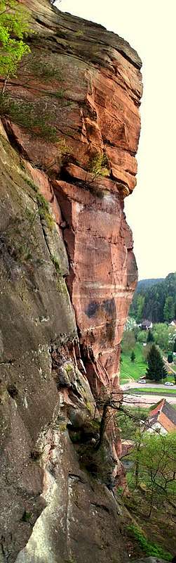
Jungfernsprung takes a special place among all the sandstone cliffs around town - and this quite literally: it is located directly in the centre of the town, towering above and dwarfing the houses at its base. It is a vertical piece of rock, 70m high, with smooth north and west faces and a (more) rugged eastern one. In reality, Jungfernsprung is but the westernmost part of a long sandstone ridge, also containing Jungfernfelsen and Vogelsbergturm. Moreover, you can find quite a number of overhanging boulders with sizes ranging up to 15m.
This ridge divides the town of Dahn into two parts, only leaving little space between its western end and the Wieslauter Creek. All traffic has to slip by the crag and so the first thing you see as you enter the town is the massive cliff of Jungfernsprung, which thus became the landmark and symbol of the town. As befits a landmark, the cliff is very popularamong all kinds of people. There are three or four hiking trails which lead up to the summit and all have been "secured" with railings and staircases. There are even benches at strategic places, among them the very top of the Jungfernsprung rock. Climbing is quite popular too, though I have never seen anybody on one of the routes myself. If you climb Jungfernsprung you can be sure to be scrutinized by everyone who comes along, probably causing traffic disturbances on the narrow main road of the town.
In between hiking and climbing there is something I like to call "exploration", a thing you can do around any of the Wasgau sandstone cliffs. Its a special scrambling type of pursuit, which leads you to improbably places right on to or in the middle of the rock faces. Jungfernsprung is a perfect object to illustrate this sport. on its northern side, the ridge, out of which Jungfernsprung sticks out to the west has numerous ledges at various elevations. These ledges start out somewhere from forest soil but soon turn into rocky ledges covered by moss, pine needles and old beech foiliage. They run all the way to the overhanging north face of the crag offering dizzying views onto the town below. The fun is a bit hazardous thanks to the smooth surfaces of the rock which offer only few handholds and the mossy cover of the ledges.
 |
 |
 |
 |
 |
 |

The Name
Jungfernsprung means "Virgin's Leap" and is based on a folk tale after which a girl, being followed by a villain (some associate him with Hans von Trotha (Hans Trapp), a local nobleman and knight infamous for his quarrels with the Weissenburg Monastery), bounded along the paths on the back of the ridge. The villain drew nearer but before he could reach her she reached the end of the ridge. Here she flung herself off the cliff but miraculously survived unhurt. At the place where her feet touched the ground a spring broke out of the ground and is still running strong today.
Climbing Routes to Jungfernsprung

The Jungfernfelsen Ridge is separated into four climbing areas. Rather than reprinting the copyrighted information from the site of the Vereinigung Pfälzer Kletterer I link to their routes database directly with some summary info. Here is the link to the complete database.
| Region | Routes link | Summary |
| Jungfernsprung | Jungfernsprung | 8 routes ranging from 5+ - 7+- |
| Jungfernfelsen, Vorderer Turm | Vorderer Turm | 9 routes ranging 1 - 3+ |
| Jungfernfelsen, Zackenturm | Zackenturm | 7 Routes with variations ranging from 1 - 4+ |
| Vogelsbergturm | Vogelsbergturm | 6 routes ranging from 1 - 5- |
Getting There
 Jungfernsprung north face
Jungfernsprung is located directly in the centre of Dahn, a 2 minute hike from the nearest parking lot. Dahn itself is hidden very deep inside Pfälzerwald and thus the itineraries are a bit longish. The closest airports are at Frankfurt and Stuttgart so the itineraries start there too.
From Frankfurt
There are two possible routes which both take equally long- Via Ludwigshafen
- From Frankfurt take motorway A5 southward to Darmstadt.
- There change to A67 south.
- At Viernheimer Dreieck turn onto A6 west. Leav
- e it at Frankenthaler Kreuz for A61 south.
- At Mutterstädter Kreuz take A65 south until you reach Landau.
- At Landau turn on B10 west.
- At Hinterweidental turn onto B427 south which will take you through Dahn. At the southern end of the town there is a roundabout. Take the third exit which leaves for the parking lot at the spa hotel.
- Via Kaiserslautern
- From Frankfurt take motorway A3 west
- At Mönchhofdreieck turn onto A67 south
- At Rüsselsheimer Dreieck take A60 west
- At Kreuz Mainz Süd take A63 south
- At Kreuz Kaiserslautern turn onto A6 west
- At Kreuz Landstuhl turn onto A62 south
- At Pirmasens turn onto B10 east
- At Hinterweidental take B427 south to Dahn
From Stuttgart
- Take motorway A8 to Karlsruhe
- At Karlsruher Dreieck turn north onto A5
- Tke the next exit to head for A65
- At Kandel you can leave onto B427 which will lead you directly to Dahn. However the detour to Landau and B10 will take less time as the roads are better (three or four lanes)
Red Tape
 Zackenturm on the Jungfernfelsen Ridge
The use of magnesia is not allowed in the whole Südpfalz region. This is rather a directive or an arrangement than an outright law. Thus you probably will get away with using it but do so only when absolutely necessary. Magnesia closes the pores which you find in the sandstone and together they form a smooth surface which will get very slippery in wet conditions. The rule of thumb is to use magnesia in the highest difficulty sections and only extremely sparingly.
A list of guidelines can be found here (in German).
Also, finding a parking place can be a bit difficult. There is an abundance of spaces but they are all privately owned and you risk bing hauled away. The closest parking lot is about 500m dowm the main road into the town centre (south). It is small, however, and you might have to take the larger lot near the spa hotel (10 minutes walk through the town to Jungfernfels).
Accommodation
In the town of Dahn you can find numerous hotels or apartments. Have a look at the tourist information site for more info. There are two campgrounds, one at Neudahner Weiher one in nearby Bruchweiler-BärenbachWeather Conditions
The closest available weather information is the one for Pirmasens (20km to the north-west):Pirmasens weather
Maps & Books
As for maps there is a good overview map (1:50000) by Kompass Verlag but the best ones are the official topographic maps by the state government of Rheinland Pfalz, scaled 1:50000, 1:25000 and 1:5000. All official maps can be found on the web page of Landesvermessungsamt Rheinland Pfalz1:50000
- Naturpark Pfälzer Wald
Kompass Map WK766
ISBN: 3-85491-523-3
- Pirmasens Süd
LVA RLP Map L6910
ISBN: 3-89637-193-2
1:25000
Books
Here are a number of climbing guidebooks on the region of Südpfalz. The best ones, however, have been published privately and are sold only in selected bookshops of the region.
- Hiking
- Pfälzerwald
B. & J.-Th. Titz
Rother Verlag
ISBN: 3-7633-4268-0 - Klettern im Buntsandstein
U. Daigger, H.-J. Cron
Published privately and out of print
- Pfalz ++, Klettern im Buntsandstein
R. Burkard, P. Weinrich
Published privately
- Klettern im Naturpark Pfälzerwald
Naturfreunde Lambrecht
Published privately - Pfalz & Nordvogesen en bloc
A. Wenner, Y. Corby, I. Bald
Panico Verlag
ISBN: 3-936740-19-4
Climbing