
-
 5387 Hits
-
 83.1% Score
-
 16 Votes
|
|
Mountain/Rock |
|---|---|
|
|
49.16424°N / 7.82801°E |
|
|
Trad Climbing, Sport Climbing, Scrambling |
|
|
Spring, Summer, Fall |
|
|
886 ft / 270 m |
|
|
Overview
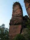
 Glasfelsen with Neyturm (left) and Schlemmerturm (right) Glasfelsen with Neyturm (left) and Schlemmerturm (right) |
Out of the many rocks and cliffs of the Südpfalz / Wasgau Climbing Region only a few stand out as they are disconnected from any surrounding hill. While most of the cliffs kind of grow out of the side of a hill these rocks and towers stand alone. They come in ones, twos and threes, Teufelstisch, Asselstein or Braut & Bräutigamm being a few of the more popular ones. Hidden in the forest nort-est of the dead-end village of Erfweiler you can find a gem of this type, Glasfelsennamed after Glastal Valley on the eastern slope of which it stands.
In order not to state an untruth - this twin tower is almost connected to a ridge which you can reach by scrambling up the neighbouring hill. A very wide step or courageous jump takes you to the easternmost tower about 5m beneath its summit. But from the hiking trail down below you get the distinctive notion of a double peaked and solitary standing rock.
While Glasfelsen is the name of the ensemble, both towers have their own names. The western one, which is lower but shows straight cut cines and edges is called Neyturm. It is elegantly shaped and curves upward in an easy bend. The tower - thanks to its smooth surfaces - is the much harder to climb with a small but difficult overhang right in its middle. Naturally it is the more popular of the twins and a number of protecting bolts and rings gives proof of that popularity.
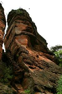
Schlemmerturm, the eastern one of the towers is at the same time the higher one. It is - as mentioned above - disconnected from the neighbouring east ridge by a small gap, the jump of which is by far the easiest route to the summit. The tower is more structures than Neyturm with a lot of layers piled one upon the other which tend to form overhangs and ledges. Only the west face, the one which faces Neyturm is considerably smooth and this is where you find the most difficult route.
It is unfortunate that the twin towers are located in such a dense forest for thare are only a few spots from which you can decent photographs. The south side is ok and so is the west face of Neyturm but everything else is hidden by trees. Especially disappointing is the approach to Schlemmerturm. While the summit is free, verything else is so overshadowed by trees and bushes that you don't stand a chance to fire a shot.
 |
 |
 |
 |
 |
Peregrine Falcons
 Schlemmerturm with a peregrine rushing by
Thanks to its little caves, overhangs and ledges, Schlemmerturm is also popular among the peregrine falcons of the area. This year (2006) a couple is nesting there, which closes the whole rock (meaning the Glasturm ensemble) to climbing until August 1st or the time the falcons abandon breeding. In this case stop signs are put up on the access trails and everyone is requested to refrain from stirring the birds.
This is quite a hard feat as I learned when arriving there to try the normal route to Schlemmerturm. I was greeted by bird cries - which at the time I could only guess to be issued by a peregrine falcon. It was sitting somewhere high up in the rock and though I remained on the hiking trail below it didn't seem to feel comfortable with my presence. A bit disappointed because of the ruined climb I took some shots from beneath the rock when the bird rose into the air, crying and circling the rock. Wherever I went it followed me and when the second bird left the nest I knew it was time to retreat. The birds are very shy which is the reason why they nearly have become extinct in the area and are protected by environmentalists and climbers alike.
A day thereafter I was chased from another crag, Wilgartisburg (a castle ruin), by another peregrine and nearby Bavariafels was closed as well. I definitely hope that the birds are on the rebound now.
Climbing Routes to the Glasfelsen Twin Towers
 Neyturm western edge
Glasfelsen and its two towers have a good set of interesting routes of all kinds. The easiest routes to both towers lead through the overgrown and well structured north face.
Rather than reprinting the copyrighted information from the site of the Vereinigung Pfälzer Kletterer I link to their routes database directly with some summary info. Here is the link to the complete database.
| Feature | Routes link | Summary |
| Neyturm | Neyturm | 11 routes with variations ranging from 3 - 7- |
| Schlemmerturm | Schlemmerturm | 4 routes with variations ranging from 3 - 7+ |
Getting There
 Neyturm south-east face
Rappenwand is located north of Erfweiler, a 10 minute hike from the last parking lot at the end of the village. Erfweiler itself is hidden very deep inside Pfälzerwald and thus the itineraries are a bit longish. The closest airports are at Frankfurt and Stuttgart so the itineraries start there too.
From Frankfurt
There are two possible routes which both take equally long- Via Ludwigshafen
- From Frankfurt take motorway A5 southward to Darmstadt.
- There change to A67 south.
- At Viernheimer Dreieck turn onto A6 west. Leav
- e it at Frankenthaler Kreuz for A61 south.
- At Mutterstädter Kreuz take A65 south until you reach Landau.
- At Landau turn on B10 west.
- At Hinterweidental turn onto B427 south which will take you to Dahn.
- In Dahn, after you have driven around Jungfernsprung there is an intersection directly in the town centre. Turn off left onto K39 which takes you to Erfweiler.
- In Erfweiler don't follow the main road (K39) where it bends right but rather go straight on (but later keep to the right) until the road ends in a parking lot
- From the parking lot follow the right hand hand trail, a dirt road which is signed "Whm Dicke Eiche". After a sharp bend in the road you get to Glasfels
- Via Kaiserslautern
- From Frankfurt take motorway A3 west
- At Mönchhofdreieck turn onto A67 south
- At Rüsselsheimer Dreieck take A60 west
- At Kreuz Mainz Süd take A63 south
- At Kreuz Kaiserslautern turn onto A6 west
- At Kreuz Landstuhl turn onto A62 south
- At Pirmasens turn onto B10 east
- At Hinterweidental take B427 south to Dahn
- In Dahn turn onto K39 to Erfweiler
- In Erfweiler go straight on to the parking lot at the end of the village
From Stuttgart
- Take motorway A8 to Karlsruhe
- At Karlsruher Dreieck turn north onto A5
- Tke the next exit to head for A65
- At Kandel you can leave onto B427 which will lead you directly to Dahn where you can turn right onto K39 to Erfweiler. However the detour to Landau and B10 (see above) will take less time as the roads are better (three or four lanes)
Red Tape
 Schlemmertum
The use of magnesia is not allowed in the whole Südpfalz region. This is rather a directive or an arrangement than an outright law. Thus you probably will get away with using it but do so only when absolutely necessary. Magnesia closes the pores which you find in the sandstone and together they form a smooth surface which will get very slippery in wet conditions. The rule of thumb is to use magnesia in the highest difficulty sections and only extremely sparingly.
A list of guidelines can be found here (in German).
Accommodation
You can find hotels and apartments in Erfweiler and in neighbouring Dahn. Have a look at the following links:There are two campgrounds, one in Dahn at Neudahner Weiher one in nearby Bruchweiler-Bärenbach.
Weather Conditions
The closest available weather information is the one for Pirmasens (20km to the north-west):Pirmasens weather
Maps & Books
Maps
As for maps there is a good overview map (1:50000) by Kompass Verlag but the best ones are the official topographic maps by the state government of Rheinland Pfalz, scaled 1:50000, 1:25000 and 1:5000. All official maps can be found on the web page of Landesvermessungsamt Rheinland Pfalz
1:50000
- Naturpark Pfälzer Wald
Kompass Map WK766
ISBN: 3-85491-523-3
- Pirmasens Süd
LVA RLP Map L6910
ISBN: 3-89637-193-2
1:25000
Books
Here are a number of climbing guidebooks on the region of Südpfalz. The best ones, however, have been published privately and are sold only in selected bookshops of the region.
- Hiking
- Pfälzerwald
B. & J.-Th. Titz
Rother Verlag
ISBN: 3-7633-4268-0 - Klettern im Buntsandstein
U. Daigger, H.-J. Cron
Published privately and out of print
- Pfalz ++, Klettern im Buntsandstein
R. Burkard, P. Weinrich
Published privately
- Klettern im Naturpark Pfälzerwald
Naturfreunde Lambrecht
Published privately - Pfalz & Nordvogesen en bloc
A. Wenner, Y. Corby, I. Bald
Panico Verlag
ISBN: 3-936740-19-4
Climbing