
-
 17552 Hits
-
 88.61% Score
-
 27 Votes
|
|
Mountain/Rock |
|---|---|
|
|
37.85590°N / 13.40040°E |
|
|
Hiking, Sport Climbing, Big Wall, Scrambling |
|
|
Spring, Summer, Fall, Winter |
|
|
5292 ft / 1613 m |
|
|
Overview
 Rocca Busambra main summit Rocca Busambra main summit |
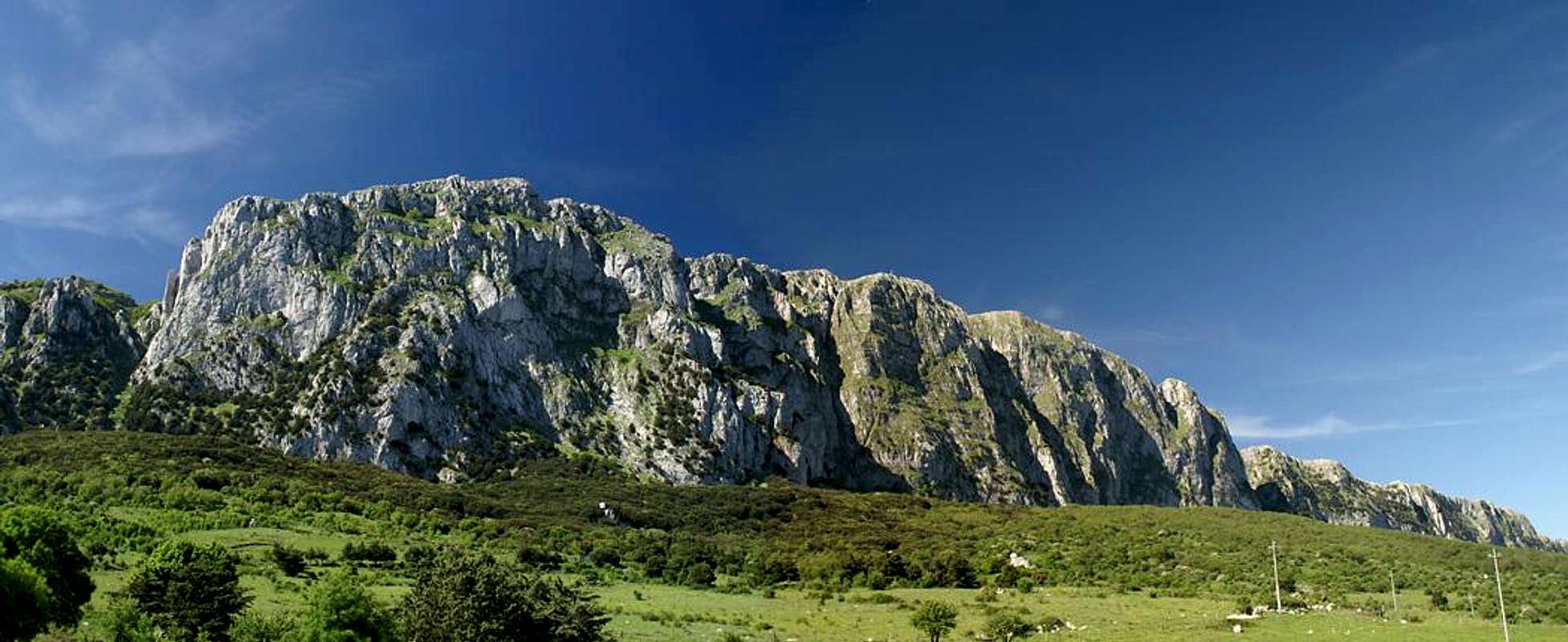
Rocca Busambra is one of the mountains of the western part of Sicily: a piece of limestone rock which rises out of the surrounding hill-like highlands south of the small town of Ficuzza (which itself is located some 40km south of Palermo). However typical that might be of the mountains of the western highlands, Rocca Busambra stands out as one among many. It has a 3km long near vertical north face with its highest point somewhere near the eastern end. From there on the mountain drops slowly to kind of fade out in its westernmost part.
From the other - that is southern - side Rocca Busambra is more accessible. A hike around its east corner reveals a steep but manageable karst slope which nevertheless poses enough difficulties, being overgrown with all kinds of beautiful Sicilian summer flowers and bushes. There are two routes onto the summit - the regular route which traverses the south slope in several switchbacks - or the summit ridge traverse. Both pose similar difficulties though the latter is considerably more exposed.
The feature of Rocca Busambra I liked best - and there are many - is its 600m vertical, slightly concave, east face. Following the regular route across the first eastern side summit step by step reveals it in all its beauty as you close in on the mountain. Astonishing as it may seem - this rock, which is so steep to all its sides (even the easy southern one), possesses a large summit plateau, which is overgrown by one of the nicest flower filled meadows. A perfect place to rest after the somewhat strenuous ascent.
As for summit views - they must be impressive. Rocca Busambra is an isolated mountain and the views range far and wide - or so they should. However, Sicily suffers sever cases of haze and/or smog so that only the closest vicinity was clearly visible during our climb. The pictures will tell you that these views alone were worth the climb.
One last remark: I am sure that at least the vertical east face is a good multi pitch climbing destination. The rock quality appears to be solid and the face drops some 600m down into the forest below. However, I haven't been able to find information about climbing the rock, so I'm either mistaken or first ascents can still be made here.
|


Panoramic view
  |
Getting There
Sicily can be reached from all Italian and the major European airports by plane. There are two large airports, one at Catania in the east and one at Palermo. Since Palermo is much closer to the mountain than Catania my itinerary starts here. Also, Palermo is the main ferry port in the area.As an aside note - there is regular bus transport on the island but the village/town of Ficuzza is certainly served not more than twice a day. Renting a car is probably mandatory.
From Palermo airport
- Take motorway A29 direction Palermo
- In Palermo the motorway turns into a four laned city highway which circles the city to its south
- The city highway turns into motorway A20 direction Catania / Messina
- At the exit Villabate turn onto SS121 direction Agrigento
- At Bolognetta turn onto SS118 south, direction Corleone
- After 16km on SS118 take the left turn for Ficuzza
- In Ficuzza drive to the castle, then left and directly right onto the broad potholed road to Rifugio Alpe Cucco where any ascent starts.
Red Tape
 Orchis papilonacea, butterfly orchid
I am not sure if this is really true but Rocca Busambra belongs to the preserve which is called Bosco di Ficuzza (an old hunting ground of King Ferdinand IV of both Sicilies), in any case it is located on the boundary. Cattle and horses are grazing in parts of the forest and on the lower slopes on the east side of Rocca Busambra, on Piano della Tramontana.
Several pastures have been fenced in though it is unclear if they are private property or if the fences are only meant to keep the animals from escaping. When climbing fences or hiking through gates, please make sure that the fence is in good condition after your passage. Even if this means that the condition is better than you met it in the first place.
Piano della Tramontana as well as the summit pasture are home to a large number of wild orchids. These flowers are protected throughout Europe - so please leave them in their place, even if they seem to pop up everywhere.
Don't camp anywhere in Bosco di Ficuzza. Rather go into the town and ask for lodgings there. On foot you will spend no more than 30 minutes getting to the trailhead.
Apart from all this, all red tape seems to be voluntary
Accommodation
You can quite easily find hotel rooms and apartments everywhere on the coasts. All European travel companies offer accommodation so a visit to your nearest travel office will find you some. In the mountains themselves accommodation is much harder to come by. Since camping is not allowed (see red tape) you have to ask at the local inns. Moreover there are some farms which offer “agriturismo” though on Sicily this often means only food and no rooms.Rifugio Alpe di Cucco may be an alternative but you need reservations
Weather Conditions
Sicily is located very close to northern Africa (Marsala on the west coast is closer to Tunis than to any place on the Italian mainland), thus temperatures can get very high. March, April and early May are the best months if you plan to hike the mountains, the winter can be wet, the summer scorchingly hot. Here the nearest weatherunderground link for Palermo:Maps & Books
Maps
Unfortunately there are no current topographic maps of Sicily. The best are reported to be more than 50 years old and probably are the same as the basis for the digital maps of atlanteitaliano.it.
As a workaround you can use street maps for general orientation together with a good guidebook (see below). The most accurate maps are scaled 1:200000, sometimes detailing everything down to forest and dirt roads through the mountains. I settled for
- Sizilien
Shell Generalkarte
1:200000
Mairs Geographischer Verlag
ISBN: 3-8297-2080-7
Books
Since there are no good topographical maps of Sicily you should take care to get a good guidebook. The one I used is in general excellent. For Rocca Busambra the route descriptions were accurate - we lost our way only one time - because we ignored the book. The book is available in German and English.
- Sizilien / Sicily
M. Omidvar
Rother Verlag
ISBN:
3-7633-4266-4 (German)
3-7633-4813-1 (English)